
What can a brochure show that ground-level photographs can’t? A well-planned aerial view can place a property in its setting, reveal its layout and bring important features into one clear frame. That’s the value of aerial photography for property brochures: not simply a higher viewpoint, but a more complete picture of what makes the property distinctive.
Choosing useful angles starts with the property story. Identify what readers need to understand, then build a focused shot list around the site’s scale, access, surroundings and key features. This guide explains how to plan an image brief, prepare for a professional drone shoot and organise aerial assets for brochure use.
Impact Aerial provides commercial drone photography in Birmingham and the West Midlands, with a structured process from consultation and site survey through to post-production and handover. Operators are CAA-GVC Certified (as of early 2026), the business holds full UK CAA Operational Authorisation and £5 million commercial liability insurance. A considered approach helps make property imagery clearer, more useful and ready to support your brochure.
Key Takeaways
- Shape aerial photography for property brochures around the property story, so each view has a clear purpose.
- Separate essential property details from optional surroundings when preparing a focused shot brief.
- Use establishing, site-layout and closer-detail views to help readers understand different aspects of the property.
- Plan the shoot around the intended brochure use and site context; operational preparation includes a site survey and safety assessment.
- Impact Aerial’s seven-stage workflow takes imagery from consultation through to handover, using professional 4K HDR-capable drone systems.
Why aerial photography gives a property brochure more useful context
Aerial photography for property brochures shows a property in relation to its site and surroundings. Rather than choosing a view simply because it looks dramatic, make useful information visible: where the building sits, how the grounds are arranged and which features help explain the setting.
An elevated viewpoint can make relationships easier to read than a series of close-up photographs alone. A broad image may show a house within its garden, the arrangement of buildings on a commercial site, or how a property meets a road or adjoining land. The right angle depends on what the brochure needs to communicate, not simply how high the drone can fly.
Think of each image as an answer to a reader’s question. Does the property have a separate entrance? How do the buildings relate to one another? Is there open space around the site? A carefully framed photograph can provide context for these details. A view chosen only for visual drama may leave readers unsure what they’re looking at.
The broader practice of aerial photography includes different methods and applications. For a property brochure, the practical priority is to choose a viewpoint that represents the site clearly. A wide frame might include nearby features for orientation, while a more tightly framed view can keep attention on the property itself.
What can an aerial view communicate about a property?
A wide view can establish the property’s position within its site and show how buildings, boundaries, grounds and access routes relate. A suitable angle may also make parts of a roof, façade or surrounding landscape visible. Match the frame to a specific question: a site-wide view can clarify layout, an approach view can explain access, and a frame that includes local surroundings can help readers understand the setting.
When does aerial photography add value to a brochure?
For commercial property, an elevated image can help explain how separate buildings or outdoor areas fit together. For a residential property, it may show the relationship between the home, garden and approach. Aerial photography is especially useful when ground-level photographs cannot easily communicate the whole site at once. Aerial photographs should complement, not replace, ground-level images, which remain useful for showing entrances, interiors and close-up details.
How to plan aerial photography for a property brochure
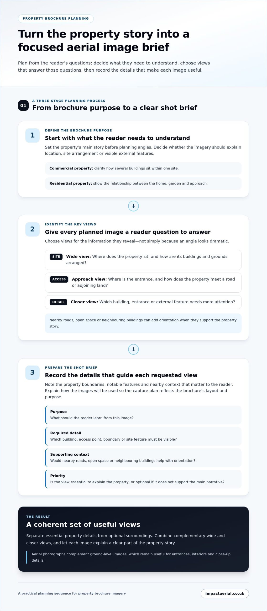
A useful image brief starts with the reader, not the drone. Decide what someone needs to understand about the property after viewing the brochure, then plan aerial views that answer those questions. This keeps aerial photography for property brochures focused on the property narrative rather than a collection of attractive but disconnected angles.
A simple planning sequence helps:
- Define the brochure purpose. Decide whether the imagery needs to explain the property’s location, the arrangement of its site or visible external features.
- Identify the key views. Match each planned image to a reader question, such as “Where is the main entrance?” or “How do the buildings relate to the grounds?”
- Prepare the shot brief. Note essential details, supporting context and how the images will be used in the brochure.
Set the brochure objective before the shoot
Start with the intended reader and the property’s main story. A commercial brochure may need to clarify how several buildings sit within one site; a residential one may need to show the relationship between the home, garden and approach. List the points each image should help communicate, then separate essential views from supplementary material that adds context but isn’t central to the story.
Build a focused aerial image brief
Record the property boundaries, notable features and nearby context that matter to the reader. Then plan complementary wide and closer views: a wide frame might establish the overall site, while a closer view could give more attention to a particular building or entrance. Explain the intended brochure use during the project discussion so the capture plan reflects the publication’s layout and purpose.
Make the brief specific enough to guide decisions without prescribing camera settings. For each requested view, write down:
- Purpose: What should the reader learn from this image?
- Required detail: Which building, access point, boundary or site feature must be visible?
- Supporting context: Are nearby roads, open space or neighbouring buildings useful for orientation?
- Priority: Is the view essential to explain the property, or optional if it doesn’t support the main narrative?
This distinction prevents optional scenery from taking priority over views that explain the site. It also gives the photographer a clear basis for discussing the brief during consultation, including practical considerations that affect the planned capture. The aim isn’t to request every possible angle, but to identify a coherent set of images for the intended reader.
A clear brief turns the property story into a focused plan for useful aerial capture. The project discussion can connect the planned views with their intended use. Impact Aerial’s commercial drone photography supports property brochure projects in Birmingham and the West Midlands.
Choose aerial brochure images for setting, scale and property detail
A useful brochure image set combines views that do different jobs. A wide photograph can introduce the property and its surroundings; a site-layout view can clarify how buildings and outdoor areas relate; a closer view can bring attention to a roof, façade or other visible feature. This variety helps readers follow the property story without asking one frame to show everything.
Use this comparison to match each view to its purpose and likely place in the brochure:
| Image type | What it can communicate | Possible brochure role |
|---|---|---|
| Establishing view | The property’s position within its wider setting, with nearby surroundings where visible and relevant. | An opening image for a property or development section. |
| Site-layout view | The arrangement of buildings, grounds, parking areas or access routes, depending on the angle and what is visible. | A supporting view alongside copy that explains the site’s layout. |
| Closer property detail | Visible features of a roof, façade or part of the grounds, subject to the image’s resolution and viewpoint. | A detail-led image that supports a specific point in the property narrative. |
A brochure sequence can move from the whole to the parts: establish the setting first, clarify the site arrangement next, then use closer views to focus attention. Give each photograph a distinct role to avoid repeating the same information across several images.
Use wide views to establish the property’s setting
A broad view can orient readers by showing where the property sits within its site and, if the framing allows, how nearby surroundings relate to it. It may work well as an introduction to a development or property section. Boundaries, roads and neighbouring features are only useful if they’re legible in the selected view and final brochure layout, so match the frame to the intended use.
Use closer views to show roofs, façades and site features
High-resolution aerial photography can capture visible roof and façade features. These views can support a brochure’s presentation, but a photograph isn’t a formal property survey and shouldn’t be used to establish condition that requires inspection or survey work. Keep captions and surrounding copy precise about what the image shows. Impact Aerial also provides Drone Property Surveys; 3D imaging and detailed topological graphics are distinct outputs, rather than something to assume a standard brochure photograph includes.
A strong brochure image set uses complementary views to explain setting, site arrangement and selected property details without making one photograph do every job. Choose each frame according to the point it needs to communicate and how it will sit alongside the brochure’s other content.
Prepare a safe, practical aerial photography brief
A strong brief connects the images you need with the practical requirements of the site. For aerial photography for property brochures, share enough context to plan purposeful views while allowing operational planning to determine how the flight can be carried out safely.
Before the shoot, gather the information that will help shape the discussion:
- Property location: Provide the site address or location and identify the relevant property or development area.
- Brochure audience: Explain who the brochure is for and what readers need to understand about the property.
- Image objectives: List the buildings, access points, boundaries or other features the photographs should communicate.
- Site context: Note nearby surroundings that matter to the property story, along with access considerations relevant to planning the visit.
- Intended use: Describe where the aerial images may appear in the brochure and how they’ll sit alongside other property content.
Separate essential views from optional context. For example, a view that explains the arrangement of buildings may be central to the brochure, while a wider view of the surroundings may simply provide orientation. This helps focus the consultation on the property’s priorities without prescribing camera settings or a fixed shoot schedule.
What information helps shape the shoot?
Start with the location, intended audience and key property features, then explain the brochure’s purpose. Include relevant access considerations and site context that could affect the planned views. A clear brief also distinguishes what readers must understand from useful supporting material. These details give the consultation a practical starting point and connect the image plan to the publication.
How safety and compliance fit into preparation
Operational planning follows a defined early sequence: Consultation, Site Survey, Safety Assessment. The consultation establishes the project objectives; the site survey informs understanding of the location; and the safety assessment considers the planned operation before flight. Impact Aerial’s pilots are CAA-GVC Certified (as of early 2026), and the company holds full UK CAA Operational Authorisation. It also carries £5 million commercial liability insurance.
These steps support a considered approach to the shoot. The site survey and safety assessment are operational stages, not simply additions to the brochure image list. If site conditions or safety considerations affect a requested view, the plan can take them into account before flight. This connects the photography brief with operational preparation and makes safety a defined part of project planning.
Impact Aerial provides commercial drone photography from Birmingham and the West Midlands, with consultation forming the first stage of the process. The project brief can bring together the brochure audience, priority views and relevant site context. Impact Aerial’s property photography service follows this structured approach.
How Impact Aerial captures and hands over brochure-ready imagery
A planned service workflow connects the property brief to the final aerial assets. For aerial photography for property brochures, the aim is to capture and prepare imagery for the project’s intended use. The photography can inform a brochure, while brochure design remains a separate task.
Impact Aerial follows this seven-stage process:
- Consultation: Discuss the project, intended brochure use and views needed to communicate the property.
- Site Survey: Review the site context to inform the capture plan.
- Safety Assessment: Assess operational considerations before the flight.
- Flight: Capture the planned aerial photography.
- Post-Production: Process the photography for presentation.
- Presentation: Present the completed work for review.
- Handover & Sign-Off: Complete the handover and sign-off process.
From consultation through post-production
Consultation establishes the project brief, including which views matter to the brochure and what readers should understand from them. The site survey informs the work with relevant site context, followed by a safety assessment before flight. Impact Aerial uses 4K HDR-capable DJI Enterprise drones, including the DJI Matrice 210, for commercial photography.
After capture, photography post-production uses Adobe Lightroom. This stage prepares the photographic assets for presentation; it doesn’t turn the service into brochure design. For video work, Adobe Premiere Pro and DaVinci Resolve are used for post-production. Keeping the distinction clear helps clients plan photography and video assets according to their separate roles.
Presentation, handover and next steps
Presentation and sign-off provide a defined point to review the completed work and bring the project to handover. The process focuses on the aerial assets, rather than designing or laying out the brochure. Final assets are delivered through a shared Google Private Cloud Drive or WeTransfer Pro, giving the client a clear handover route.
A defined workflow also helps keep the original brief in view through capture, post-production and delivery. If the brochure calls for a particular balance of wide context and closer property views, those priorities can guide the work from consultation onwards.
Impact Aerial provides commercial aerial photography from Birmingham and the West Midlands. Project discussions can cover the property, intended brochure use and planned views through the company’s photography service.
Turn the property story into a clear image plan
Decide what a prospective reader should understand at a glance. A clear visual sequence can take them from the property’s setting to its layout and the details that matter, giving every image a defined role in the brochure. That’s the practical value of aerial photography for property brochures: imagery shaped around the property story, rather than a collection of disconnected views.
Before planning a shoot, note the brochure’s audience, the property features that need to be shown and the context that will help readers make sense of them. These priorities give the photography brief a useful starting point and keep the project focused on the images the publication needs.
Impact Aerial provides commercial drone photography in Birmingham and the West Midlands. Request a free, no-obligation quote for your property brochure photography, and share the story you want the images to tell.
Frequently Asked Questions
Can aerial photography show the setting of a property in a brochure?
Yes. An aerial view can help readers understand how a property sits within its site and surrounding area. For example, it may show the relationship between a building, its grounds and a nearby road, depending on the viewpoint. For aerial photography for property brochures, choose a view that supports the brochure’s purpose. A single photograph won’t communicate every site detail, so pair it with other relevant images or copy.
What should I include in an aerial photography brief for a property brochure?
Include the brochure audience, the property features readers need to understand, relevant surroundings and how the images will be used. Identify essential views first, such as a building entrance or the arrangement of a site, then note supplementary imagery that could provide context. During consultation, these priorities help shape the project. A site survey adds information about the location, allowing the capture plan to reflect the property.
Is aerial photography suitable for showing roof and façade condition?
High-resolution aerial imagery can capture views of visible roof and façade features, which may help illustrate a property in a brochure. However, a photograph isn’t automatically a formal survey or technical assessment, and it shouldn’t be treated as proof of defects or their absence. Impact Aerial provides Drone Property Surveys as a separate service. Explain the intended use during project consultation so the imagery and any survey requirements are considered appropriately.
How are aerial photographs delivered for a property brochure?
Impact Aerial delivers final assets via a shared Google Private Cloud Drive or WeTransfer Pro. Your brochure designer or marketing team can then use the supplied photographs within the publication’s layout. This handover keeps the photography separate from brochure design, so your team can place the imagery alongside copy and other property visuals.
Does aerial photography for a property brochure require safety planning?
Yes. Professional drone photography involves project-specific preparation before flight. Impact Aerial’s workflow includes a Site Survey and Safety Assessment to inform operational planning for the property and proposed work. All operators are CAA-GVC Certified (as of early 2026), and the company holds full UK CAA Operational Authorisation. These credentials support a structured approach to commercial drone operations, while the site-specific assessment helps guide planning for each project.
How much does aerial photography for property brochures cost?
The cost depends on the requirements of the property photography project. Impact Aerial offers a free, no-obligation quote, which is not the same as free photography. To request a quote, share the property location, the brochure’s purpose and the views you’re considering. This information gives the team a starting point for understanding the project.
 2 Norton Drive, Wythall, Birmingham, B47 6HH Company registration number: 11138586. VAT Number: 366 9068 55


