
What if an apparent clash is actually a problem with the survey data? Clash detection using drone point clouds can help teams compare site conditions with a design or BIM model, but the result is useful only when capture detail, alignment and tolerances are understood. A mismatch on screen isn’t automatically a construction conflict.
It’s reasonable to question whether drone-captured data is detailed enough, or whether a flagged discrepancy reflects a genuine issue. The answer depends on the task, how the data was captured and registered, and how it is compared with the model. Check those factors before acting on a difference, so the team can investigate findings rather than rely on misleading results.
This guide explains when drone point clouds may suit a clash review, what can affect their reliability, and how to plan a practical capture-to-comparison workflow. You’ll learn how to distinguish possible physical conflicts from alignment or capture error, and how to present findings for project teams to assess and follow up. Professional aerial surveys and drone data collection can also contribute site information to a wider verification workflow, alongside capabilities such as 3D imaging and detailed topological graphics.
Key Takeaways
- Understand what clash detection using drone point clouds can reveal, and how it differs from identifying design clashes between model elements.
- Set the comparison question and scope before planning capture, so the collected data is relevant to the project review.
- Choose between aerial capture, terrestrial scanning and existing project data according to access, visibility, required detail and project tolerances.
- Review differences in context before treating them as actionable. Consider location, affected elements, evidence quality and project relevance.
- See how aerial surveys and drone data collection can contribute site information to a wider verification workflow, supported by a focused project brief.
What Clash Detection Using Drone Point Clouds Can, and Cannot, Show
Clash detection using drone point clouds compares captured site geometry with a design model to identify spatial conflicts or differences that may need review. A point cloud is captured three-dimensional surface data represented by many measured points. It records visible surfaces, not every concealed component or design requirement.
A model-based clash and an as-built deviation are related, but they answer different questions. A clash is a spatial conflict between elements or design requirements, such as two proposed building services occupying the same space. Deviation checking compares observed site conditions with intended geometry, such as a constructed façade that appears offset from its designed position.
For a foundational explanation of virtual intersections, see Collision Detection. To see an example of model-based clash checking, watch this overview of clash detection with IFC:
Clash detection versus as-built deviation checking
In design coordination, a clash usually flags a conflict within or between planned elements. Field verification instead asks whether the built or existing condition matches the intended geometry. A drone-derived surface may show that a roof edge differs from the model, but that observation alone doesn’t establish a defect. The model may be outdated, the comparison may be misaligned, or the difference may fall within the tolerances agreed for the task. Interpret each result against the project context and relevant tolerances, then investigate before deciding what action is needed.
What drone-derived data may reveal, and what it may miss
Aerial capture can contribute information about visible roofs, façades and other exposed surfaces. It may help a project team examine whether an external surface or feature appears to differ from its planned position. Impact Aerial provides aerial surveys and drone data collection, including high-resolution roof and façade condition imagery, 3D imaging and detailed topological graphics. These outputs can contribute site information to a wider verification workflow.
Visibility sets a clear boundary. Parapets, overhangs, dense services, trees or adjacent structures can obscure surfaces, while access constraints may affect what can be captured. A difference in a comparison can reflect occlusion, incomplete coverage, capture noise or alignment error, as well as a genuine site deviation. Treat each finding as an investigation prompt, not automatic proof of a construction defect. 4K HDR imagery or 3D imaging alone does not establish point-cloud accuracy. The capture method and evidence must suit the comparison question.
How to Move from Drone Capture to a Point-Cloud Comparison
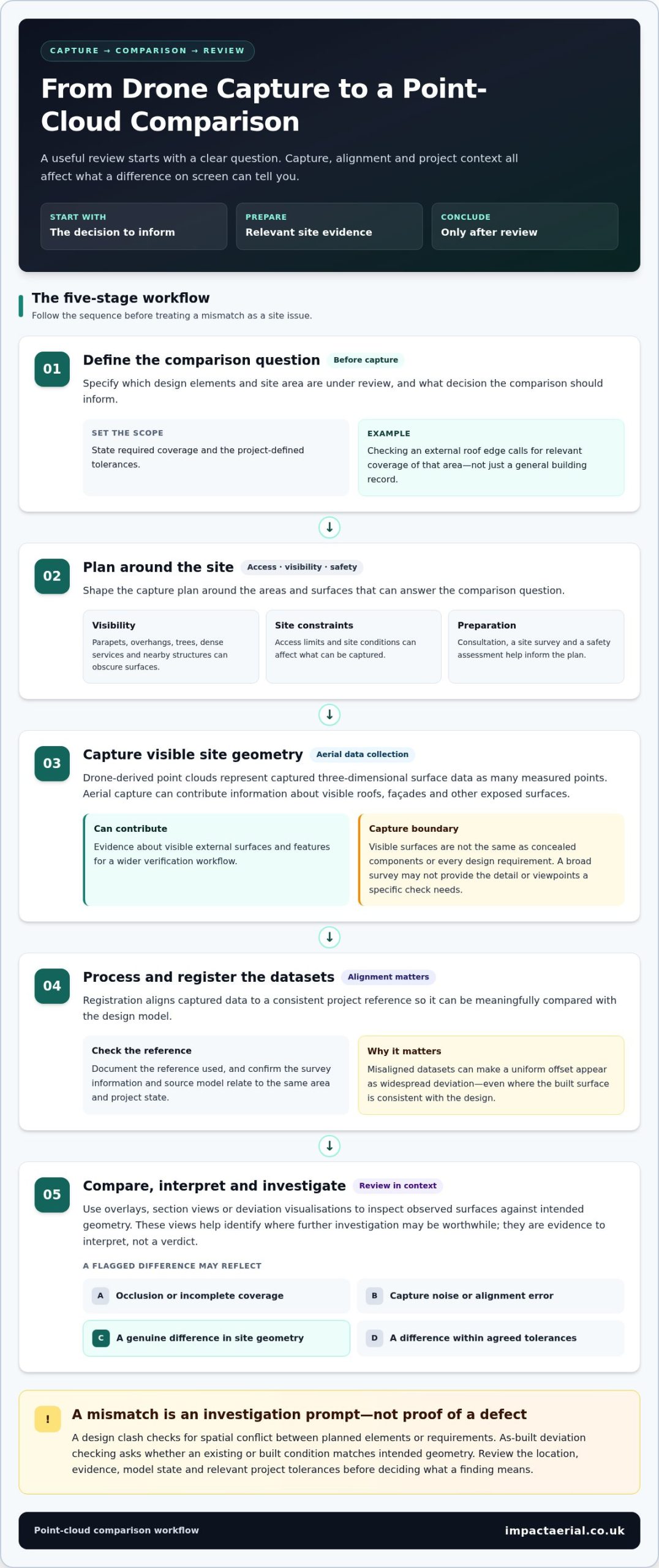
A useful comparison starts before a drone takes off. First identify the decision the data should inform, then plan capture around the areas and surfaces that can answer it. Comparison quality depends on suitable capture and correctly aligned datasets. A broad site survey may provide useful context, but it won’t necessarily capture the detail or viewpoints required for a specific model check.
For clash detection using drone point clouds, distinguish aerial data collection from the later point-cloud processing and comparison. Aerial surveys can contribute observations of visible site conditions to the project team’s wider verification workflow. The data then needs to be processed and registered, compared with the appropriate design information, and reviewed in context.
Define the comparison before planning the flight
Begin with a concise brief: which design elements are under review, which part of the site matters, and what question should the comparison answer? For example, a team checking an external roof edge needs relevant coverage of that area, not simply a general record of the building. State the required coverage and project-defined tolerances before choosing a capture approach, so the survey plan reflects the intended use of the evidence.
Planning should also account for access, site conditions and safety requirements. Existing structures, obstructions and restricted areas can affect what is visible from the air. Consultation, a site survey and a safety assessment help shape a planned capture around the site and its constraints. This preparation supports focused data collection, but the resulting data still needs to be assessed for the intended comparison.
Process, align and compare the datasets
Once captured, the data must be prepared for review. Registration means aligning the captured dataset to a consistent project reference so its position can be compared meaningfully with the design model. If the datasets are not aligned, a uniform offset may appear as widespread deviation, even where the built surface is consistent with the design. Document the reference used and check that the source model and survey information relate to the same area and project state.
Teams can use overlays, section views or deviation visualisations to inspect how observed surfaces relate to intended geometry. These methods help reveal where further investigation may be worthwhile, but the display is evidence to interpret, not a verdict. Keep the review within the project team’s chosen coordination environment, with the comparison scope and relevant tolerances clear to those assessing results.
- Define the elements, area and decision the comparison must support.
- Plan aerial capture for the required coverage, visibility and site conditions.
- Process the captured data and register it to the agreed project reference.
- Compare the aligned datasets using views suited to the review question.
- Review differences against project context and agreed tolerances before assigning action.
Impact Aerial’s aerial surveys and drone data collection can contribute site information to this wider workflow. Its service follows Consultation, Site Survey, Safety Assessment, Flight, Post-Production, Presentation, Handover & Sign-Off. For projects in Birmingham and the West Midlands, aerial data collection can be scoped around the site information the team needs to investigate.
Drone Point Clouds, Other Capture Methods and Project Tolerances
No single capture method suits every comparison. Aerial data can provide broad views of exposed external surfaces, while terrestrial scanning can focus on areas reached from ground level. Existing project information, such as drawings, models or earlier survey data, may already answer some questions, but its age, scope and reference must be understood. A dataset is suitable only when its limitations fit the decision being made.
For clash detection using drone point clouds, suitability depends on the question, visibility, required detail and tolerances set for the project. Aerial coverage may be useful for checking visible roof geometry or façade conditions across a site. It may be less appropriate on its own for a concealed connection, an internal space or a small detail that needs close inspection. Match the evidence to the decision rather than assuming one dataset can verify every element.
When aerial capture may suit the site question
Aerial capture can document elevated or difficult-to-access surfaces where ground-level views are limited. This can help teams review visible roof and façade conditions without relying solely on access at height, and drone surveys may reduce the need for scaffolding. They don’t replace scaffolding in every case. Obstructed, internal or concealed elements may need other project information or a different form of inspection to provide relevant evidence.
Consider a review of roof plant against a design. Aerial imagery may show the accessible, exposed arrangement, while hidden supports or components behind an upstand may not be visible. Existing drawings or other survey information could help address those gaps. The capture plan should identify which surfaces need to be seen and flag areas where obstructions could limit the evidence.
How tolerance, alignment and coverage affect confidence
Before comparing datasets, distinguish local or relative alignment from their position in the wider project coordinate reference. A scan can appear to match a model when both are aligned to each other, yet still sit incorrectly against the project reference. Conversely, a reference mismatch can create an apparent offset across a whole area. Record the basis of alignment and assess whether it suits the comparison being made.
Coverage matters too. Missing or obscured surfaces leave gaps, while registration error can make measured differences misleading. A project-defined tolerance gives reviewers a basis for judging whether an observed difference merits investigation. It should come from the project specification or team agreement, not an assumed universal threshold.
- Aerial capture: Consider for visible, elevated external surfaces and broader site coverage.
- Terrestrial scanning: Consider where ground-level access and focused views address the question.
- Existing project data: Use when its coverage, reference and currency are appropriate to the review.
Keep observed evidence distinct from an interpreted clash finding. A visible offset is an observation; deciding that it represents a relevant conflict requires checking coverage, alignment, tolerance and design context. This distinction makes the comparison easier to communicate and helps the team direct follow-up to areas where the evidence supports further investigation.
How to Review and Prioritise Point-Cloud Clash Findings
A comparison can flag differences quickly, but speed doesn’t make every result reliable or actionable. A highlighted area may reflect a genuine deviation, or it may come from incomplete coverage, alignment problems or the way the data is displayed. In clash detection using drone point clouds, treat automated and visual outputs as leads for review, not confirmed construction defects.
Start by checking the evidence, then assess the project impact. A minor visible difference in a non-critical area may need a different response from a possible conflict that affects coordinated elements or a significant project decision. Make that distinction clear without overstating what the captured data proves.
Separate actionable differences from capture artefacts
Check whether an apparent conflict persists from more than one view or in a relevant section comparison. Review whether the surface is obscured, sparsely captured or difficult to interpret, and revisit the dataset’s alignment before assigning a classification. If the difference depends on a single view or uncertain evidence, record it as requiring investigation. Refer observations that need specialist interpretation to the relevant project discipline rather than labelling them confirmed clashes.
Use a consistent review sequence:
- Confirm the comparison concerns the intended site area and model elements.
- Check the observed difference in additional views or section comparisons where available.
- Review coverage and alignment, and note any evidence limitations.
- Decide whether the finding is supported, requires investigation or cannot be assessed from the available data.
Document findings so project teams can act
Each record should help another team member locate and understand the issue without having to reconstruct the review. Include the site location, relevant model context, observed condition and supporting visual evidence. State what appears different, where it appears and what remains uncertain. Use agreed labels to distinguish a finding accepted for action from an observation awaiting investigation.
Grouping findings supports a focused coordination discussion. Organise them by location and affected elements, then consider evidence quality and project relevance. This helps teams see whether several flags relate to one underlying question or need separate follow-up. Avoid treating the number of highlighted areas as a measure of risk; the evidence and project context matter more.
Record unresolved questions, the discipline or team responsible for follow-up, and the next action through the project’s existing coordination process. Keep supporting views and references with the finding, and handle information in line with the project’s agreed workflow. Clear records make it easier to revisit a decision when additional evidence becomes available.
Impact Aerial’s aerial data collection services can contribute site information to a wider verification workflow, planned around the areas and conditions your project team needs to review.
Plan Drone Data Collection for a Clash-Detection Workflow
A focused brief helps aerial data collection serve a clear project purpose. Before planning a survey, establish what the team needs to understand, which site areas matter and how the resulting information will be used. For clash detection using drone point clouds, describe the comparison question without assuming that aerial capture alone provides a point cloud, BIM comparison or clash report.
Impact Aerial provides aerial surveys and drone data collection for built-environment professionals. Its Aerial Surveys and Drone Service for Data Collection can contribute site information to a project team’s wider verification workflow. Confirmed capabilities include high-resolution roof and façade condition imagery, 3D imaging, detailed topological graphics and Thermal Image Surveys. These outputs can support project understanding and should be described according to what they show.
Information to prepare for an aerial survey brief
Give the capture team practical context before the project is planned. A concise brief can include:
- Site question and intended use: Explain what the project team wants to observe and how the information will inform its review.
- Target areas: Identify relevant roofs, façades or other exposed areas, and describe the coverage needed.
- Project references: Share relevant design information and the project-defined coverage or tolerance requirements that will guide interpretation.
- Site conditions: Note access arrangements, obstructions, occupied areas and other constraints that may affect the survey or visibility.
These details help shape the initial consultation, site survey and safety assessment. They also make it easier to identify where aerial observations could contribute and where the wider project team may need other information to address concealed or inaccessible elements. Keep the intended comparison and its limits explicit, so findings can be interpreted in the right context.
What to expect from Impact Aerial’s confirmed workflow
Impact Aerial follows this sequence: Consultation, Site Survey, Safety Assessment, Flight, Post-Production, Presentation, Handover & Sign-Off. This gives the project a structured route from discussing requirements and assessing site conditions through to presenting and handing over the agreed work. A clear brief helps align the capture with the site and its intended use.
All operators are CAA-GVC Certified as of early 2026, and the company holds full UK CAA Operational Authorisation and £5 million commercial liability insurance. These credentials support professional aerial operations, while the project brief keeps capture aligned with the site and its intended use.
With the scope and relevant project references prepared, discuss the aerial survey requirements with Impact Aerial. Learn about requesting a free, no-obligation quote for aerial data collection to support your project workflow.
Set Up Your Next Site Review with a Clear Brief
The value of clash detection using drone point clouds depends on more than identifying a difference on screen. It depends on having a clear project question, relevant site evidence and an agreed route for investigating what the comparison reveals. Use your next coordination discussion to decide which areas need attention, what evidence would help and who will assess unresolved observations.
That clarity gives aerial data collection a defined role within the wider verification process. Impact Aerial’s aerial surveys, drone data collection, 3D imaging and detailed topological graphics can contribute site information for built-environment projects. Its pilots are CAA-GVC Certified as of early 2026, the company holds full UK CAA Operational Authorisation, and it carries £5 million commercial liability insurance.
Prepare the site question and project references, then request a free, no-obligation quote from Impact Aerial to discuss a focused capture plan.
Frequently Asked Questions
Can a drone point cloud be used for clash detection?
Yes, a drone-derived point cloud can be compared with a design model to help investigate spatial conflicts, particularly where the relevant surfaces are visible and captured adequately. For example, a team might examine whether an exposed roof feature appears in a different position from its designed location. The point cloud offers evidence of captured conditions; project specialists still need to judge whether a difference is meaningful and what follow-up it warrants.
How does clash detection using drone point clouds work?
Clash detection using drone point clouds involves comparing captured site geometry with selected design information. The team identifies the area and elements to review, prepares the datasets, aligns them to a suitable reference and inspects any differences. For instance, a roof-level review might focus on visible plant and surrounding surfaces. Reviewers then check whether a flagged difference reflects the site, the model or a limitation in the evidence before assigning action.
What is the difference between clash detection and deviation analysis?
Clash detection asks whether elements or requirements occupy conflicting space, often within a design or coordination model. Deviation analysis asks how an observed condition differs from an intended shape or position. For example, two proposed service routes may conflict before installation, while a surveyed wall that appears out of line with its design raises a deviation question. The right interpretation depends on the comparison purpose and the project’s decision criteria.
Are drone point clouds accurate enough for BIM coordination?
They may suit some coordination checks, but suitability depends on capture coverage, visibility, alignment and the detail the project decision requires. There isn’t one accuracy threshold that fits every BIM task. A broad review of exposed external geometry has different demands from checking a small interface between components. Compare the expected evidence with project-defined requirements, and use a more appropriate source where the drone data cannot support the required judgement.
When should a project use a drone survey instead of terrestrial scanning?
A drone survey may suit a question about visible, elevated external areas, such as roof condition or façade geometry across a building. Terrestrial scanning may be more appropriate when the work needs close views from ground level, detailed internal coverage or access to areas hidden from aerial viewpoints. The methods can also complement each other. Choose according to the site question, access, visibility and required detail, rather than treating them as interchangeable.
Can drone point clouds detect hidden clashes behind walls or ceilings?
No, a drone point cloud represents surfaces that were captured, so it can’t directly reveal components concealed behind a wall, ceiling or other obstruction. For example, an aerial view of a roof may show the outer surface but not a hidden connection beneath it. To examine concealed conditions, a project team needs relevant design records, other suitable survey information or an inspection method that provides evidence of the hidden area.
What information should I provide when commissioning drone data collection for clash review?
Provide the site location, areas of interest, the question the review needs to answer and how the information will be used. Include relevant design references, expected coverage, project-defined tolerance requirements and known access or safety constraints. Note obstructions or areas that need particular attention, such as a roof zone beside taller structures. This context helps the aerial survey team plan a focused capture and helps the project team interpret the resulting evidence.
 2 Norton Drive, Wythall, Birmingham, B47 6HH Company registration number: 11138586. VAT Number: 366 9068 55


