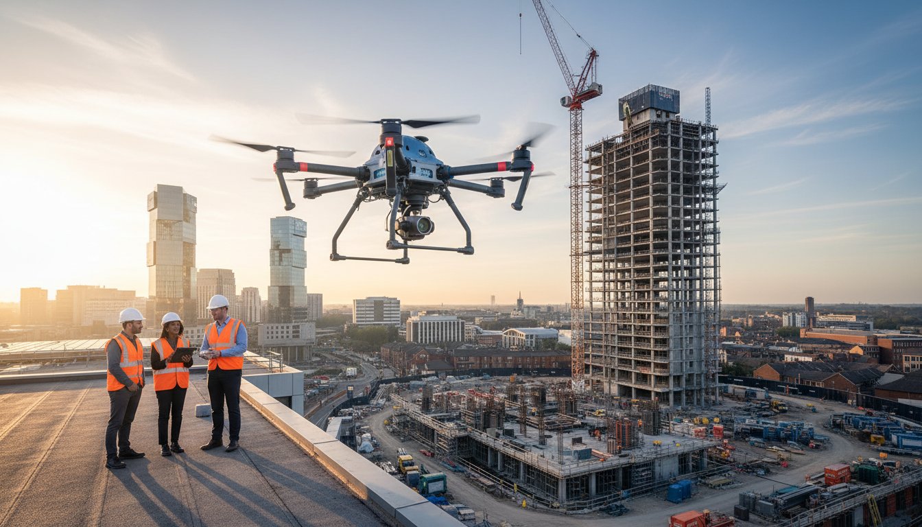
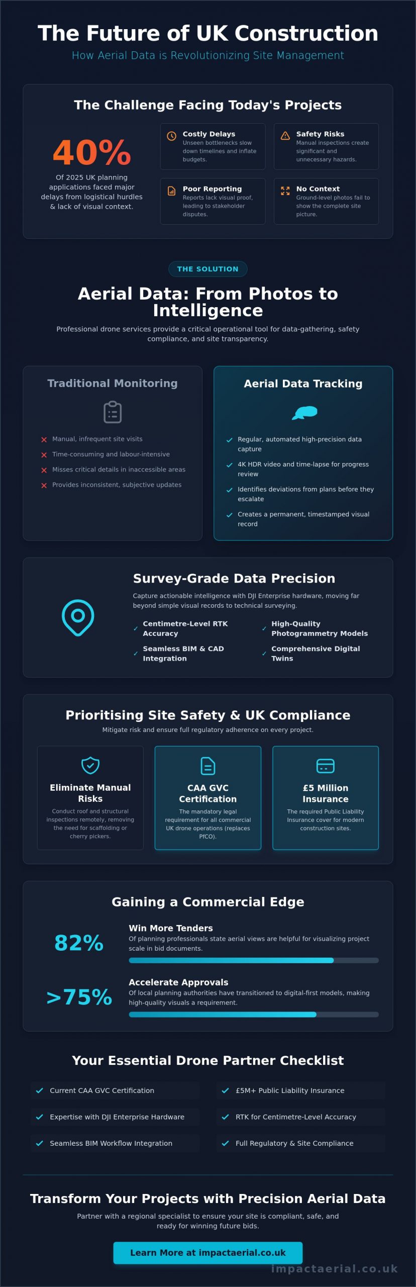
In 2025, over 40% of UK planning applications faced significant delays because of logistical hurdles and a lack of visual context. If you’re managing a large-scale project, you understand the constant pressure to monitor progress efficiently while mitigating the safety risks of manual inspections. It’s frustrating when stakeholder reports lack the high-quality visual assets needed to demonstrate real-world momentum. Professional aerial photography for construction firms is no longer just a marketing luxury. In 2026, it’s a critical operational tool for data-gathering, safety compliance, and site transparency.
You’ll learn how professional drone services transform site monitoring through remote inspections and seamless BIM integration. This guide outlines exactly what to look for in a drone partner, from current CAA GVC certification to the £5 million public liability insurance required for modern UK sites. We’ll preview how high-quality photogrammetry and digital twins provide a comprehensive record of your site’s context. This ensures your project remains compliant, safe, and ready for winning future bids with total peace of mind.
Key Takeaways
- Understand the legal necessity of the CAA GVC certification and why it has replaced the outdated PfCO for all commercial site operations in 2026.
- Explore how high-precision DJI Enterprise drones capture 4K HDR data to bridge the gap between simple visual records and technical site surveying.
- Discover how professional aerial photography for construction firms streamlines daily site briefings and safety inductions by providing real-time visual context.
- Learn to integrate cinematic RAW and post-produced footage into your existing BIM workflows for enhanced project transparency and stakeholder reporting.
- Identify the operational benefits of partnering with a regional specialist to ensure meticulous data-gathering and full regulatory compliance on complex sites.
Why Aerial Photography is Essential for Modern Construction Firms
In 2026, the UK construction industry has moved far beyond simple progress snapshots. Professional aerial photography for construction firms now serves as a sophisticated, multi-stage documentation and data tool that spans the entire project lifecycle. While the history of aerial photography began with balloons and fixed-wing aircraft, today’s 4K HDR drones provide a level of precision that traditional ground-based photography simply cannot match. You get a comprehensive view of the site that identifies bottlenecks before they become costly delays.
This shift toward high-resolution drone coverage provides undeniable “visual proof” for stakeholders and insurance providers. Having a verifiable, timestamped record of site conditions at every stage protects your firm against liability claims and helps resolve disputes quickly. It’s also becoming a standard requirement for as-built documentation. When it’s time for contract retention release, having a complete aerial history of the build provides the objective evidence needed to trigger payments. This meticulous approach ensures that every phase of the project is recorded with technical accuracy.
To better understand how this technology integrates with site data, watch this helpful video:
The Evolution of Site Progress Monitoring
Traditional site monitoring often relies on manual monthly visits, which are time-consuming and often miss critical details in hard-to-reach areas. Automated aerial tracking replaces these inconsistent updates with regular, high-precision data-gathering. Our fleet captures 4K HDR video that creates a permanent record of site conditions. These assets are often compiled into time-lapse sequences, allowing project managers to review months of work in minutes. This level of detail is essential for identifying deviations from the original site plan early. It provides a level of oversight that was previously impossible without significant manual labour.
Commercial Advantages and Winning New Tenders
The competitive landscape for UK construction has changed. With 82% of planning professionals stating that aerial perspectives are helpful for visualizing scale, high-quality imagery is now a necessity for PQQ submissions and bid documents. Using drone footage for community engagement and local planning updates can also accelerate the approval process by providing clear context to residents and officials. In an era where ESG (Environmental, Social, and Governance) reporting is critical, aerial visuals provide transparent evidence of environmental mitigation and site safety compliance. By 2026, over 75% of local planning authorities have transitioned to digital-first models, making these high-quality visual assets a requirement for any complex application.
Technical Applications: From Site Inspections to Data Collection
Professional aerial photography for construction firms has evolved into a high-precision data-gathering exercise. While standard drone photography focuses on aesthetic value, technical surveying uses DJI Enterprise hardware to capture actionable intelligence. Our fleet utilizes RTK (Real-Time Kinematic) modules to achieve centimetre-level positioning accuracy. This technology allows project managers to identify site issues, such as drainage pooling or boundary encroachments, long before they escalate into costly remedial works. By 2026, the distinction between a simple visual record and a technical survey has become a fundamental requirement for Tier 1 contractors.
Remote Aerial Inspections and Surveys
Traditional roof inspections often require expensive scaffolding or cherry pickers, which introduce significant health and safety risks. Using survey drones allows for a safer, faster alternative that doesn’t disrupt ground-level operations. These drones detect structural anomalies like hairline fractures or loose masonry that are invisible from the ground. We also deploy thermal imaging sensors to identify heat loss or moisture ingress within building envelopes. This proactive approach ensures all operations remain compliant with CAA drone safety regulations while providing a meticulous record of the asset’s condition.
Integrating Drone Data with BIM and CAD
The real power of modern aerial data lies in its integration with Building Information Modelling (BIM) and CAD software. We use photogrammetry to process thousands of high-resolution images into 2D orthomosaic maps. These maps provide distortion-free, top-down views that allow for precise on-screen measurements of stockpiles, foundations, and site boundaries. For more complex projects, we generate 3D meshes that architects can overlay with their proposed designs to check for tolerances. Creating a digital twin through drone data improves stakeholder collaboration by providing a dynamic, shared record of the site’s current state. This level of technical detail is why many firms now partner with specialist aerial consultants to manage their data workflows.
By 2026, over 75% of UK construction firms have adopted digital-first models where drone data is the primary source for site verification. This transition ensures that every stakeholder, from the site foreman to the off-site investor, has access to the same high-quality visual data. It’s a structured, methodical approach that replaces guesswork with verified, technical evidence.
Prioritising Site Safety and CAA Compliance in the UK
Operating a drone on a live build is a high-stakes task that requires more than just technical skill. It demands a rigorous commitment to safety and a deep understanding of current UK aviation law. For any reputable provider of aerial photography for construction firms, compliance isn’t optional. It’s the foundation of the service. By 2026, the Civil Aviation Authority (CAA) has established the General Visual Line of Sight Certificate (GVC) as the mandatory standard for commercial operations on complex, built-up sites. Hiring an operator who only holds an A2 CofC or an outdated PfCO exposes your firm to significant legal and financial risks.
Every flight we conduct is backed by a minimum of £5 million in specialist commercial liability insurance. This level of coverage is standard for Tier 1 and Tier 2 UK construction environments, providing the necessary protection against unforeseen incidents. We also produce site-specific Risk Assessments and Method Statements (RAMS) before every take-off. These documents aren’t just paperwork. They are live safety protocols that ensure our pilots and your site personnel remain protected. This meticulous approach reflects the broader advances in aerial imagery which now prioritise operational safety alongside data quality.
The Importance of CAA GVC Certification
A professional drone license is the minimum entry requirement for any construction project. The GVC certification ensures that a pilot has undergone rigorous training in airspace management and emergency procedures. Unlike hobbyist flyers, GVC-certified professionals are vetted to operate in congested areas and near complex structures. This provides you with peace of mind, knowing that the pilot can safely navigate the busy airspace around your project while maintaining full control of the aircraft at all times. It’s about ensuring that your data-gathering doesn’t become a liability.
Managing Risks on Active Construction Sites
Active sites present unique hazards, including tower cranes, high-voltage lines, and moving plant machinery. We manage these risks through a structured, methodical flight plan. Our pilots work alongside a dedicated ground observer who maintains a constant 360-degree watch for potential hazards. This is especially critical in densely populated areas like Birmingham and the West Midlands, where site boundaries are often tight. By following these strict protocols, we ensure that the data-gathering process never compromises the safety of your workforce or the surrounding public. Our goal is to provide a seamless, non-intrusive service that integrates perfectly with your existing site safety culture.
Maximising ROI: Integrating Aerial Assets into Your Workflow
Investing in aerial photography for construction firms is only the first step; the real value lies in how you deploy those assets within your daily operations. We deliver a combination of RAW data for your technical teams and post-produced cinematic 4K HDR footage for your commercial departments. This dual-purpose approach ensures that every flight serves both operational and promotional needs. Many of our clients use these visuals during daily site briefings to show workers exactly where high-risk activities are taking place. It’s an effective way to improve safety inductions by providing a clear, top-down view of the site’s changing landscape in 2026.
The role of professional drone services becomes particularly evident during project handover. By providing a comprehensive visual history of the build, you offer the client a level of transparency that builds long-term trust. We also implement 360-degree virtual tours, which allow stakeholders to perform remote walkthroughs of the site from any location. This technology is essential for keeping off-site investors engaged without the logistical burden of frequent site visits.
Post-Production and Content Delivery
Professional editing transforms technical data into high-impact marketing assets. We create project highlight reels specifically designed for LinkedIn and PR, showcasing your firm’s ability to manage complex builds. These branded videos don’t just record progress; they build a reputation for innovation and technological adeptness. Delivery of these large 4K data sets is handled via secure, cloud-based platforms. This ensures your team can access high-resolution assets instantly, whether they’re in the head office or on-site in the West Midlands.
Stakeholder Reporting and Transparency
Aerial imagery simplifies communication with non-technical stakeholders who may struggle to interpret complex CAD drawings. A 2023 survey of UK planning professionals indicated that 82% found these perspectives helpful for visualizing the scale of proposed developments. A single high-resolution photograph provides immediate clarity on project status, reducing the time spent in lengthy progress meetings. This data is also invaluable for dispute resolution. If a subcontractor claims progress that isn’t visible on the weekly flight, you have timestamped, objective evidence to verify the facts. Regular aerial updates significantly reduce the need for physical site visits, saving your senior management team hours of travel time every month.
To see how these assets can be integrated into your specific project, book a consultation with our technical team today.
Partnering with Impact Aerial for Your Construction Project
Selecting a partner for aerial photography for construction firms requires more than just reviewing a portfolio. It’s about finding a technical consultant who understands the operational realities of a 2026 construction site. We provide a structured, methodical approach that prioritises site safety and data precision above all else. Our fleet consists of the latest 4K HDR DJI Enterprise drones, specifically chosen for their ability to capture high-precision data in challenging environments. Every operation we conduct is backed by our CAA GVC certification and £5 million in commercial liability insurance, ensuring you have total peace of mind throughout the project lifecycle.
Our Regional Expertise in the West Midlands
Our deep local knowledge of Birmingham and the West Midlands is a significant advantage for your project. We understand the specific airspace challenges of the region, from the congested city centre to the expanding industrial zones along the M6 corridor. Being a local partner allows us to offer rapid deployment and flexible scheduling for site re-visits, which is essential when weather conditions or project milestones shift unexpectedly. We don’t just fly drones; we act as technical consultants who understand the local planning landscape. This expertise ensures that the data-gathering process is seamless and compliant with all local authority requirements. Our presence in the region means we’re always available for face-to-face briefings or urgent data requests as your project evolves.
Customised Drone Solutions for Every Phase
We tailor our drone photography to meet your specific project KPIs at every stage of development. During the initial planning phase, we provide high-resolution land surveys that inform your site layout and logistics. As the build progresses, we transition into regular monitoring, providing the visual evidence needed for stakeholder reporting and safety compliance. Finally, we deliver polished “as-built” marketing packages that showcase the completed project in the best possible light. This end-to-end service ensures that you have a consistent, high-quality record of the entire build. Whether you need RAW data for technical analysis or cinematic footage for a high-stakes tender, we provide the exact assets you need to succeed.
Every construction site has unique requirements and challenges. We invite you to discuss your specific project needs with our technical team, from initial planning applications to final completion. We’ll help you identify the most effective ways to integrate aerial data into your existing workflows to maximise your return on investment. For added peace of mind and a bespoke project consultation, contact us today to see how our professional services can support your next build.
Elevate Your Site Intelligence with Technical Precision
By 2026, the transition to digital-first assessment models has made high-quality visual data an industry standard. You’ve seen how integrating high-precision 4K HDR imagery with BIM workflows replaces guesswork with objective, timestamped evidence. This structured approach to aerial photography for construction firms ensures that every stakeholder has access to a dynamic record of site progress. It isn’t just about capturing views; it’s about maintaining a meticulous and compliant data-gathering process that protects your project’s bottom line.
Choosing a partner with CAA GVC Certified pilots and £5 million in commercial liability insurance provides the necessary peace of mind for operating on complex UK sites. As Birmingham-based West Midlands experts, we understand the specific airspace challenges of the region and are ready to deploy our fleet to support your project from initial planning to final handover. The technical advantages of drone-derived digital twins and remote inspections are clear. We look forward to helping you achieve a more efficient, safe, and transparent construction workflow.
Request a bespoke aerial photography quote for your project
Frequently Asked Questions
Do I need special permission to have drones fly over my construction site?
You must have permission from the land owner or site manager to take off and land the aircraft. For projects in congested areas or near restricted airspace, professional pilots manage all necessary CAA notifications and flight planning. This structured approach ensures your operation remains legal and avoids the heavy fines associated with non-compliant commercial flights.
How much does aerial photography for construction typically cost in the UK?
Basic property shoots in 2026 typically range from £200 to £400, while half-day rates for site progress reports are between £450 and £700. For large-scale projects requiring full-day surveys, forecasted rates fall between £800 and £1,200. Specialist services like 3D photogrammetry start at £750, reflecting the technical expertise required for professional aerial photography for construction firms.
What happens if the weather is bad on the day of the scheduled flight?
Safety is our priority, so flights are rescheduled if wind speeds exceed 20mph or during periods of heavy precipitation. Our pilots monitor meteorological data 48 hours in advance to provide your team with early warnings. If weather prevents a flight, we coordinate the next available clear window to ensure your site monitoring stays on schedule.
Can drone photography help with my firm’s health and safety compliance?
Drone technology improves safety by replacing high-risk manual inspections with remote 4K HDR data-gathering. This removes the need for personnel to work at height on scaffolding or fragile roofing structures. Every flight is conducted under a site-specific Risk Assessment and Method Statement (RAMS), which provides the documented evidence required for rigorous health and safety audits.
How quickly can I expect the aerial data or photos after the flight?
Standard high-resolution images and RAW footage are typically delivered via secure cloud link within 24 hours. More complex data sets, such as processed 2D orthomosaic maps or 3D digital twins, require 48 to 72 hours for technical processing. This rapid delivery ensures your site briefings and stakeholder reports are always based on the most current information available.
What is the difference between an A2 CofC and a GVC certified pilot?
The A2 CofC is suitable for low-risk operations with smaller drones, but the General Visual Line of Sight Certificate (GVC) is the mandatory standard for complex construction sites. GVC-certified pilots are specifically trained to operate enterprise-grade hardware in congested areas. This higher level of certification is essential for maintaining the safety standards expected by Tier 1 contractors.
Is drone photography suitable for indoor construction monitoring?
Indoor monitoring is highly effective when using specialized drones equipped with 360-degree obstacle avoidance sensors and protective prop guards. This application is particularly valuable for documenting internal structural elements during the “first fix” stage. It provides a meticulous record of building services before they are concealed by internal finishes or cladding.
How high can a drone fly over a construction site in the UK?
The legal altitude limit for commercial drone operations is 400 feet (120 metres) above ground level. This height provides an optimal balance for capturing wide-angle site overviews while maintaining the resolution needed for technical data. If your project requires a higher altitude for specific surveying tasks, we must coordinate special permissions through the Civil Aviation Authority.
