
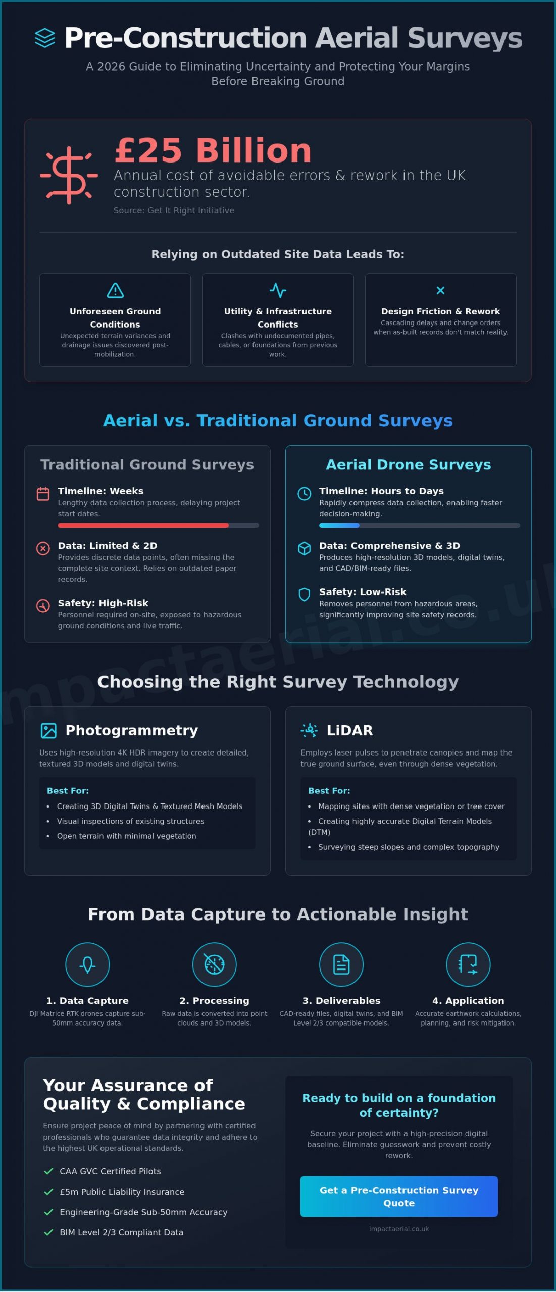
Did you know that avoidable errors and rework cost the UK construction sector an estimated £25 billion annually, according to data from the Get It Right Initiative? It’s a staggering figure that most developers experience first-hand when unexpected terrain variances or utility conflicts appear only after the machines are on site. You’re likely familiar with the design friction caused by outdated as-built records and the prohibitive costs of waiting weeks for traditional ground-based topographic surveys.
Commissioning a professional pre-construction aerial survey provides the technical precision you need to eliminate this uncertainty. This definitive 2026 guide shows you how to secure accurate, BIM-ready data and high-resolution 3D models that protect your margins before the first spade hits the dirt. For added peace of mind, we’ll explain how meticulous CAA GVC certified drone operations and advanced photogrammetry accelerate planning permissions and mitigate the risk of costly earthwork surprises.
Key Takeaways
- Identify why relying on legacy site data is a high-risk strategy in 2026 and how establishing a high-precision digital baseline prevents costly rework.
- Evaluate the engineering-grade differences between Photogrammetry and LiDAR to select the most effective pre-construction aerial survey technology for your specific terrain.
- Discover how to compress data collection timelines from days to hours while significantly improving site safety by removing personnel from hazardous ground conditions.
- Learn the workflow for converting raw drone data into CAD-ready files and digital twins that support BIM Level 2/3 requirements for modern engineering teams.
- Ensure project peace of mind by understanding the critical importance of CAA GVC certification and £5m liability insurance for compliant UK site operations.
The Hidden Risks of Outdated Site Data in 2026
In the 2026 UK construction landscape, relying on legacy site data is a gamble that professional developers can no longer afford to take. A modern pre-construction aerial survey acts as a high-precision digital baseline, capturing the current state of a site with sub-50mm accuracy. This data forms the foundation of a project’s “Golden Thread” of information, ensuring that every stakeholder works from a single, verified reality rather than outdated 2D plans. An Aerial survey using photogrammetry or Lidar provides the granular detail necessary for complex civil works and urban regeneration projects where margins for error are non-existent.
To better understand how this technology integrates into the early stages of a build, watch this helpful video:
The “Truth of the Site” vs. Paper Records
Traditional “as-built” records are often dangerously inaccurate, especially on brownfield sites where previous developments have left undocumented infrastructure. In 2025, industry reports indicated that 18% of UK infrastructure projects suffered delays due to “unforeseen” ground conditions. A drone-led survey identifies subtle drainage patterns and elevation shifts that paper maps miss. It spots utility conflicts and access constraints before a single excavator arrives on site. By creating a visual time-capsule, developers gain a layer of legal protection against future boundary disputes or damage claims from neighbouring properties. This meticulous approach ensures that what you see in the digital twin is exactly what crews will find on the ground.
The Cost of Rework: A Data-Driven Perspective
The financial impact of “discovery” issues during the mobilization phase can be devastating to a project’s bottom line. Early-stage aerial intelligence offers a proven return on investment; for every £1 spent on high-accuracy site mapping, developers typically save £4 to £6 in avoided rework. Defensible data is a tool for cost-control that provides an indisputable record of site conditions at the point of handover. This intelligence prevents the “change order chain reaction” where one miscalculation leads to a cascade of expensive delays. As UK planning requirements trend toward mandatory digital site twins, having this pre-construction aerial survey data ensures compliance with the latest safety and environmental regulations. Impact Aerial provides this added peace of mind through CAA GVC certified pilots, ensuring all data-gathering meets the highest professional standards and provides the reliability your investors demand.
- Eliminate reliance on 10-year-old council maps.
- Identify 100% of surface-visible utility markers and access hurdles.
- Provide contractors with millimetre-accurate volumetric data for earthworks.
How Pre-Construction Drone Surveys Transform Site Intelligence
Modern site intelligence relies on the deployment of DJI Enterprise drones, such as the Matrice 350 RTK, to capture engineering-grade data that ground-based teams simply cannot match for speed or perspective. These platforms don’t just take pictures; they act as flying data-gathering hubs. By utilizing 4K HDR imagery, developers can identify subtle site features like drainage patterns, minor structural cracks in neighbouring buildings, or hidden utility markers before ground is even broken. This level of visual clarity is vital for risk mitigation during the early stages of a pre-construction aerial survey.
LiDAR and Photogrammetry: The Technical Edge
Choosing between LiDAR and photogrammetry depends on your specific terrain. LiDAR is indispensable when you’re dealing with dense vegetation or steep slopes. Its laser pulses penetrate the canopy to map the true ground surface, providing a Digital Terrain Model (DTM) that photogrammetry can’t achieve in overgrown areas. Conversely, high-resolution photogrammetry is the preferred choice for creating 3D digital twins and textured mesh models for visual inspections. Both technologies achieve centimetre-level precision when paired with RTK (Real-Time Kinematic) technology, ensuring your data maintains an accuracy of 1-3cm across the entire site.
Beyond Photos: The Deliverables That Matter
The output of a professional survey goes far beyond simple photography. Developers receive orthomosaic maps, which are geometrically corrected to provide a perfectly scaled, high-resolution foundation for site overviews. These maps allow for precise measurements of distances and areas directly from a desktop. For those managing earthworks, volumetric calculations provide data on stockpiles and excavations with up to 99% accuracy. Point clouds and textured mesh models allow architects to visualize new structures within the existing environment, significantly reducing design errors. This data-driven approach can reduce site survey time by up to 75% compared to traditional land surveying techniques.
Safety and compliance aren’t optional in the UK. Operating in complex airspace, especially in urban centres or near restricted zones, requires GVC certified pilots who understand the latest UK Civil Aviation Authority regulations. This certification ensures that every flight is conducted legally and safely, providing the necessary documentation for site insurance and local planning authorities. For added peace of mind, partnering with an experienced professional aerial survey team ensures your pre-construction aerial survey is executed with meticulous attention to detail, meeting all UK safety standards while delivering the high-quality data your project demands.
Aerial vs. Traditional Ground Surveys: A Strategic Comparison
Traditional topographic surveys often tie up site resources for days or even weeks. In contrast, a pre-construction aerial survey allows developers to capture high-resolution data in a fraction of that time. For a standard 20-hectare site, a manual ground team might spend four days on-site. A professional drone pilot completes the data-gathering phase in under two hours. This efficiency isn’t just about speed; it’s about the volume of information. While a ground surveyor might capture 500 individual points, a single drone flight generates millions of data points, creating a high-density point cloud that offers a far more granular view of the terrain.
Linear corridors, such as new road links or utility pipelines, present unique challenges for ground teams. Surveying a 5km corridor traditionally involves significant logistical planning and manual labour. Using drones reduces these costs by approximately 40% to 60% while providing a continuous orthomosaic map that ground-based points simply cannot replicate. To ensure sub-centimetre precision, we utilise a hybrid approach. This involves integrating high-density aerial data with strategically placed Ground Control Points (GCPs). It combines the speed of flight with the undeniable accuracy of traditional surveying benchmarks, providing the best of both worlds for technical teams.
Speed and Efficiency in Planning Cycles
Drones accelerate the feasibility stage of property development by providing instant, shareable digital assets. Instead of waiting weeks for a manual report, stakeholders can access 3D models and orthomosaic maps shortly after the flight. This rapid turnaround reduces the need for multiple site visits by architects, engineers, and environmental consultants. Capturing data for a drone survey happens without site disruption, meaning existing operations or preliminary groundworks don’t have to stop for the survey to take place.
Safety and Risk Mitigation
Safety remains our primary directive. By removing surveyors from steep embankments, marshland, or areas with heavy plant machinery, we eliminate thousands of potential ‘at-risk’ hours annually. The use of drones in construction significantly improves overall site health and safety by keeping personnel away from hazardous or unstable terrain. Our operations are conducted by CAA GVC Certified pilots who adhere to strict flight safety protocols. For added peace of mind, we maintain £5m commercial liability insurance, ensuring that every pre-construction aerial survey is backed by professional risk management and industry-leading standards.
- Reduced Man-Hours: Surveying tasks that took days are now finalised in hours.
- Environmental Protection: No heavy equipment or foot traffic is required in sensitive ecological zones.
- Comprehensive Documentation: Full visual records of site conditions before any ground is broken.
- Regulatory Compliance: Fully insured and CAA-authorised operations for every UK project.
Integrating Drone Data into Your BIM and Planning Workflow
A pre-construction aerial survey delivers far more than just high-resolution imagery. It provides the geospatial foundation for the entire project lifecycle. We move beyond raw data by processing photogrammetry into CAD-ready files that engineering teams can use immediately. This seamless transition from flight to software ensures that site constraints are identified before a single spade hits the ground. It’s about turning visual information into actionable intelligence.
BIM-Ready Deliverables and Standards
Our data-gathering process is designed for precision. We export high-density point clouds and textured meshes in formats like .LAS, .OBJ, and .RCP for direct integration into Revit and AutoCAD. This supports BIM Level 2 and 3 workflows, providing a digital twin of the existing site conditions. For renewable energy projects, these 3D models are essential for solar farm shading analysis. We simulate the sun’s path across the digital terrain to determine optimal panel placement and layout. Maintaining data compatibility across the survey drone ecosystem is vital; it prevents information silos and ensures every stakeholder works from a single version of the truth.
Visualisation for Stakeholder Buy-In
Securing planning permission in the UK often requires more than just technical drawings. Immersive visualisations bridge the gap between complex engineering and public understanding. We provide 4K, High Dynamic Range (HDR) aerial video that brings project proposals to life for public consultations and investor updates. This transparency is reinforced through before and after site monitoring, which tracks progress and keeps stakeholders informed throughout the construction phase.
- Interactive Virtual Tours: We create web-based 3D environments for pre-build property marketing, allowing potential buyers or tenants to explore the site virtually before construction finishes.
- Remote Collaboration: Site data is shared via cloud-based platforms, allowing project managers in Birmingham and architects in London to inspect the site simultaneously without travel costs.
- Compliance and Safety: Every flight is conducted by CAA GVC Certified pilots, ensuring all data is captured legally and safely for added peace of mind.
By integrating these digital assets early, developers reduce the risk of costly design changes. The precision of a pre-construction aerial survey provides the technical certainty required for complex UK developments. It’s a meticulous approach that replaces guesswork with measurable, high-quality data. This level of detail is becoming the standard for professional site management in a niche but increasingly diverse market.
Ready to upgrade your project data? Contact Impact Aerial to discuss your BIM integration requirements.
Why Impact Aerial is the Trusted Partner for UK Construction
Impact Aerial positions itself as a technical consultant for developers who require precision, reliability, and absolute legality. A professional pre-construction aerial survey is not just about capturing imagery; it involves delivering actionable data that meets rigorous UK safety standards. We operate in a niche but increasingly diverse market, providing the technical expertise needed to de-risk complex sites before any groundworks begin. Our approach ensures that every stakeholder, from site managers to investors, has access to high-quality, ground-truth data.
Safety, Compliance, and the CAA
The regulatory landscape for drone operations in the UK has moved through several iterations. We’ve managed the transition from the legacy PfCO system to the current drone license standards required by the Civil Aviation Authority (CAA). Impact Aerial holds full GVC (General Visual Line of Sight Certificate) accreditation. This is the gold standard for legal site operations in 2026, allowing us to fly in complex environments that uncertified operators cannot access.
For added peace of mind, we back every mission with £5 million in commercial liability insurance. This level of indemnity is a standard requirement for major UK construction firms and provides essential protection for high-value development sites. We handle the entire compliance burden, including:
- Detailed site-specific risk assessments and RAMS.
- Airspace checks and local authority notifications.
- Meticulous flight planning in congested urban areas.
- Coordination with nearby airports or restricted zones.
Our commitment to professional 4K HDR DJI Enterprise technology ensures that the data we gather is as sharp as it is accurate. These commercial-grade drones are built for data-gathering and photogrammetry, providing the clarity needed for 3D site modelling and structural analysis. We manage the entire lifecycle of the data, from the initial consultation through to the final post-production of high-resolution maps and models.
Your Next Steps: Securing Your Site Data
Requesting a tailored quote for your pre-construction aerial survey is a simple, structured process. We start by defining your specific data requirements. Some projects need simple high-angle progress shots, while others require survey-grade orthomosaic maps for BIM integration. Our team evaluates your site’s location and topography to provide an accurate estimate that reflects the project’s complexity.
The consultation process allows us to align our flight plan with your construction milestones. We don’t believe in a one-size-fits-all approach. Instead, we offer a bespoke service that delivers the exact perspectives and data points your engineering team requires. This ensures your project starts with the most accurate site intelligence possible.
Call to Action: Contact Impact Aerial today for a professional site assessment. Let our experts handle the technical and regulatory complexities while you focus on building the future. Reach out via our contact page to secure a quote and schedule your survey.
Securing Your Site’s Future with Precision Intelligence
Modern UK development requires more than just guesswork. Relying on site data from even twelve months ago introduces unnecessary risk into your 2026 planning cycle. A professional pre-construction aerial survey eliminates these blind spots by delivering high-resolution, BIM-compatible datasets that ground-based methods simply can’t match. You’ll gain a comprehensive digital twin of your site, ensuring every stakeholder works from a single, accurate source of truth. This level of detail is no longer a luxury; it’s a requirement for staying competitive in a fast-moving industry.
Impact Aerial provides the technical expertise and regulatory compliance necessary for complex construction environments. Our team operates a fleet of the latest DJI Enterprise 4K HDR drones. We capture every detail with professional precision. For added peace of mind, we carry £5m commercial liability insurance and all our pilots are CAA GVC certified. This commitment to safety and quality ensures your project starts on a firm foundation. We’re ready to help you transform your site intelligence into a strategic advantage.
Contact Impact Aerial today for a professional pre-construction survey quote and let’s get your project moving forward with confidence.
Frequently Asked Questions
What is included in a standard pre-construction aerial survey?
A standard pre-construction aerial survey includes high-resolution orthomosaic maps, 3D point clouds, and Digital Surface Models (DSM). We provide 4K topographic data and high-quality site photography that establishes a visual baseline for the entire project. These deliverables integrate directly into BIM software like Autodesk Revit or Civil 3D. Our GVC certified pilots also provide a detailed safety risk assessment and flight logs to ensure full CAA compliance.
How accurate is drone-captured data for engineering purposes?
Drone-captured data achieves sub-centimetre accuracy when using Real-Time Kinematic (RTK) positioning and Ground Control Points (GCPs). For engineering purposes, we typically deliver a Ground Sampling Distance (GSD) of 1.5cm per pixel or better. This level of precision meets the RICS Band E specification for topographic surveys. It allows developers to calculate earthwork volumes within a 3% margin of error compared to traditional ground-based methods.
Do I need to notify neighbours before a drone survey takes place?
You don’t have a legal requirement to notify neighbours if the flight stays within the UK’s Open Category or Specific Category regulations. However, we recommend informing adjacent landowners 48 hours in advance to provide peace of mind and maintain positive community relations. Our team provides professional notification templates that outline our CAA credentials and insurance details. This transparency reduces privacy concerns and prevents unnecessary interruptions during the data-gathering phase.
Can drones fly in high-density urban areas like Birmingham or London?
Drones can fly in high-density urban areas like Birmingham or London provided the operator holds a CAA GVC (General Visual Line of Sight Certificate). We manage the complex airspace permissions required for London’s restricted zones, such as EGR160 (The City). For added safety, we use DJI Enterprise drones with 360-degree obstacle avoidance. Our £10 million commercial liability insurance ensures every urban pre-construction aerial survey is fully protected against unforeseen risks.
How long does it take to process the data after the flight?
Data processing typically takes between 48 and 72 hours after the flight is completed. Large-scale sites exceeding 50 hectares may require up to 5 business days for full photogrammetry rendering and 3D mesh generation. We deliver the final files via a secure cloud portal for immediate download. This rapid turnaround allows project managers to begin site planning 70% faster than they would with traditional manual surveying techniques.
What happens if the weather is poor on the scheduled survey day?
We reschedule the survey to the next available clear-weather window if wind speeds exceed 20mph or if there’s active precipitation. Most DJI Enterprise drones are IP54 rated; however, high-quality data-gathering requires dry conditions and stable light for the best results. Our team monitors Met Office aviation forecasts 24 hours before deployment to minimize site disruptions. There’s typically no additional mobilisation fee for weather-related delays if we’re notified within our agreed contract terms.
Is a drone survey cheaper than a traditional land survey?
Drone surveys are often 30% to 50% cheaper than traditional land surveys because they significantly reduce the time spent on-site. A manual surveyor might take 3 days to cover a 20-acre plot, whereas a drone completes the flight in under 45 minutes. This efficiency lowers labour costs and eliminates the need for expensive plant hire or scaffolding during the initial inspection. You save money while receiving a more comprehensive data set including millions of individual data points.
