
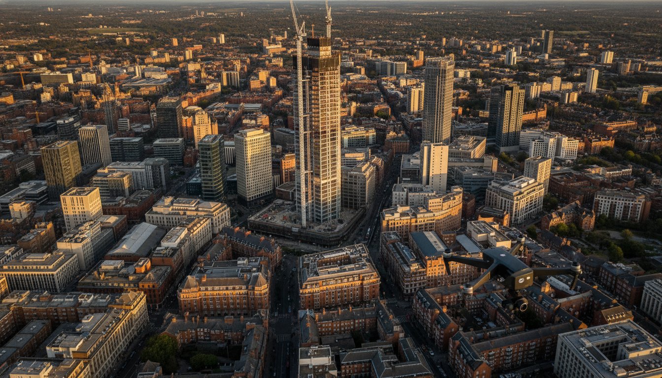
As Birmingham’s skyline reaches new heights with projects like the 155-meter One Eastside tower, the view from the ground no longer tells the full story of your development’s progress. You likely recognize that capturing the scale of these “supertall” structures requires more than just a standard camera; it demands precision and absolute compliance with the 2026 UK drone regulations. Relying on uncertified operators isn’t just a risk to your marketing quality, it’s a liability you can’t afford in a dense urban environment.
This article demonstrates how professional aerial photography services Birmingham can transform your project through high-resolution 4K HDR visuals and a meticulous, safety-first approach. We’ll explore how CAA GVC certified pilots and DJI Enterprise technology ensure your marketing assets and construction monitoring remain both stunning and fully compliant with the latest Remote ID and night-flying requirements. You’ll discover how to leverage £5m commercial liability insurance and expert post-production to secure a zero-incident safety record while obtaining elite visual data for the West Midlands’ most ambitious developments, from the Beorma Quarter to the HS2 Curzon Street Station terminus.
Key Takeaways
- Learn why Birmingham’s vertical expansion, including landmark projects like One Eastside, makes aerial perspectives essential for modern property marketing and urban planning.
- Discover how utilizing 4K HDR DJI Enterprise technology provides the stability and visual clarity needed to showcase large-scale developments in dense urban environments.
- Understand the critical role of CAA GVC certification and £5m liability insurance when selecting aerial photography services Birmingham to ensure full regulatory compliance.
- Explore how construction site monitoring and commercial surveys provide accurate, high-resolution data for tracking project milestones from the ground up.
- Gain insights into the benefits of partnering with local West Midlands specialists who offer end-to-end support from initial flight planning to final post-production editing.
Birmingham’s Skyline Evolution: The Role of Aerial Photography in 2026
Birmingham is undergoing a radical vertical transformation. Driven by the ambitious “Big City Plan,” the skyline is being reshaped by supertall structures like the 155-metre One Eastside residential tower, which stands as a testament to the city’s regeneration. In 2026, these developments represent more than just architectural milestones; they’re complex engineering feats that require precise documentation. Traditional ground-level photography often fails to capture the sheer scale of these sites. This is why professional aerial photography services Birmingham have become an operational necessity, providing the elevation needed to document progress that’s simply invisible from the street.
The transition from using drones as a novelty marketing tool to an essential piece of project documentation is now complete. While the history of aerial photography began with rudimentary cameras on balloons, today’s DJI Enterprise drones offer a level of stability and technical precision that was previously impossible in dense urban wind tunnels. Impact Aerial supports this evolution by providing high-resolution data that serves as a single source of truth for project managers, ensuring that every phase of the West Midlands’ growth is recorded with clinical accuracy.
To better understand the operational environment and visual potential of drones in the West Midlands, watch this helpful video:
Capturing the Big City Plan
Visualising the transformation of Curzon Street Station and the surrounding HS2 developments requires a comprehensive perspective. We provide developers with a bird’s eye view that’s vital for stakeholder meetings and planning permissions. For high-density residential projects, a drone can illustrate how a building interacts with its environment, showing proximity to transport links and public spaces. This aerial context is indispensable for projects like the Paradise redevelopment, where multiple phases must be coordinated within a tight city-centre footprint.
Marketing Birmingham’s New Landmarks
Professional Drone Photography Services: Technical Excellence in the West Midlands
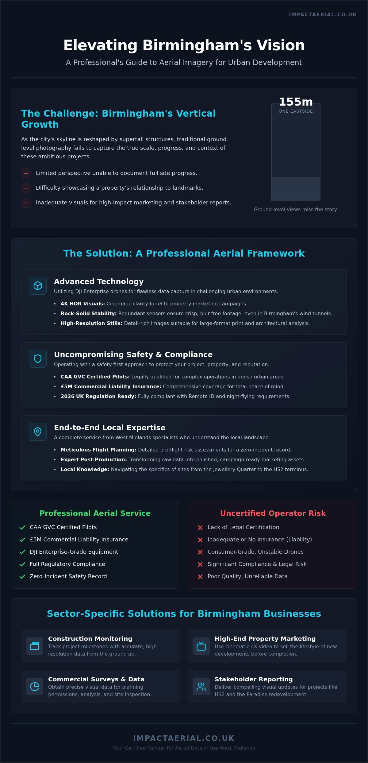
Delivering professional aerial photography services Birmingham requires more than just a drone; it requires a mobile data-capture platform. Birmingham’s city centre is notorious for wind tunnels created by high-rise clusters like the Paradise redevelopment. Consumer-grade drones often struggle with stability in these conditions, leading to motion blur or inconsistent framing. We utilise DJI Enterprise drones specifically for their advanced propulsion systems and redundant sensors, which maintain rock-solid stability even in challenging West Midlands weather. This hardware choice isn’t just about safety; it’s about the precision of the data we collect for your project.
Our operations are strictly aligned with UK drone safety regulations, ensuring that every flight is planned with meticulous attention to detail. This technical discipline extends to the resolution of our outputs. For large-format print and billboard marketing, standard digital stills aren’t sufficient. We provide ultra-high-resolution stills that maintain clarity even when scaled for massive site hoardings or corporate displays. This level of detail is essential for developers who need to present their vision with absolute clarity to stakeholders and potential investors.
Enterprise-Grade Drone Technology
DJI Enterprise models provide a level of data precision that consumer drones can’t match, particularly regarding GPS accuracy and sensor reliability. In the often-overcast light of the West Midlands, high-dynamic-range (HDR) sensors are essential for capturing detail in both deep shadows and bright highlights simultaneously. 4K HDR aerial filming is the industry standard for 2026 clarity, providing a visual depth that standard 4K simply cannot reproduce. This technology ensures that every architectural nuance of your Birmingham project is visible, regardless of the time of day or lighting conditions.
Post-Production and Final Delivery
Providing high-tier aerial photography services Birmingham involves managing every technical variable, from the initial flight plan to the final pixel. The capture is only the first stage of our full project management approach. Our post-production team handles the colour grading and editing to create cinematic reels that are ready for immediate use. We deliver assets in various formats, including:
- High-bitrate 4K HDR video for corporate presentations and TV advertising.
- Optimised social media clips for Instagram and LinkedIn campaigns.
- Uncompressed high-res stills for billboards and site hoardings.
For a deeper look at how these visuals are created, read our comprehensive drone photography guide. If you’re ready to showcase your development’s progress, our team provides professional aerial filming and photography to ensure your project stands out.
Safety and Compliance: Navigating Birmingham’s Airspace
Birmingham’s urban environment presents a dense network of obstacles, from the high-traffic corridors around Birmingham New Street to the strictly controlled airspace surrounding the international airport. Operating a drone here isn’t just about getting the shot; it’s about meticulous risk mitigation. Every flight we conduct follows the UK’s official Drone and Model Aircraft Code, ensuring that safety remains the primary objective. For commercial projects in the West Midlands, ignoring these protocols can lead to heavy fines and significant legal liabilities for both the operator and the client. Professional aerial photography services Birmingham require a deep understanding of these local restrictions to ensure every mission is legally sound.
Why GVC Certification is Non-Negotiable
As of 2026, the General Visual Line of Sight Certificate (GVC) is the essential standard for any pilot operating in the Specific Category, which covers most urban commercial missions. While some operators may still reference older PfCO standards, the GVC is the current benchmark for competency in congested areas. Our pilots have undergone rigorous assessments to prove their expertise in emergency procedures and airspace management. This qualification is a core requirement for a valid uk drone license for commercial work, providing the legal framework needed to fly near buildings and people that would otherwise be off-limits.
Privacy and GDPR compliance are equally critical when flying in high-density residential areas like the Jewellery Quarter or the newly developed Perry Barr. We employ strict data-handling protocols, including flight path planning that avoids residential windows and post-production techniques such as pixel blurring for sensitive information. This meticulous approach ensures your project documentation doesn’t inadvertently breach privacy laws or cause local friction.
The Value of £5m Liability Insurance
Corporate sites in Birmingham, particularly those involving major infrastructure or high-value real estate, require robust financial protection. Standard consumer insurance often falls short, providing limited coverage that doesn’t account for the specific complexities of a commercial construction site. We carry £5m commercial liability insurance as a standard provision. This high level of indemnity isn’t just a number; it’s a reassurance to your stakeholders that every potential risk, however unlikely, has been fully accounted for.
Our safety-first operational philosophy means we won’t fly if the conditions aren’t right. Whether it’s unpredictable wind speeds around the city’s “supertall” towers or potential GPS interference near heavy rail infrastructure, our pilots make informed decisions based on safety rather than just the project schedule. This reliability is why leading developers choose our aerial photography services Birmingham to protect their reputation and their site assets.
Sector-Specific Solutions for Birmingham Businesses
Birmingham’s diverse economy requires tailored aerial solutions. From the massive logistics hubs near the M6 to the retail density of the Bullring, our aerial photography services Birmingham provide the specific visual data needed for different commercial objectives. We don’t just capture images; we deliver sector-specific intelligence that helps project managers and marketing directors make informed decisions. Whether your focus is on the “Big City Plan” developments or infrastructure maintenance, our approach is always dictated by your specific project requirements.
Construction Site Monitoring and Progress
Construction projects in the West Midlands move at a rapid pace. We provide regular flight schedules that turn complex builds into manageable time-lapse documentation. This isn’t just for marketing; it allows project managers to track progress against milestones with high-resolution precision. By conducting remote inspections of roofs and high-level structures, we significantly reduce the need for scaffolding and risky manual checks. This improves site safety and lowers operational costs across the board. For a full breakdown of these capabilities, see our drone survey guide.
Property and Advertising Excellence
Marketing high-end real estate in Birmingham’s creative districts like Digbeth requires a specific aesthetic. We use DJI Enterprise drones to capture the “vibe” of these areas, providing unique perspectives for corporate advertising campaigns that ground-level cameras can’t achieve. Our 4K HDR visuals are designed for immediate use in professional listings, ensuring that office and retail spaces are presented with the prestige they deserve. Our virtual tour creation service provides an immersive marketing experience, allowing potential tenants to explore Birmingham’s new office developments from anywhere in the world. This is particularly effective for large-scale projects like the Beorma Quarter, where high-resolution 360-degree views can accelerate the leasing process.
Beyond visuals, we support the region’s green energy transition through specialised technical services. Our PV Solar Farm Thermal Surveys use calibrated sensors to detect cell defects that are invisible to the naked eye, ensuring maximum efficiency for renewable energy assets. This data-centric approach extends to infrastructure assessments, where we provide high-resolution mapping for Birmingham’s expanding transport network and HS2-related works. If your business needs accurate data or cinematic marketing assets, our team provides professional drone commercial property surveys and filming to elevate your next project.
Partnering with Impact Aerial: Your Local Birmingham Experts
Choosing the right partner for aerial photography services Birmingham involves more than just comparing technical specifications. It requires a specialist who understands the intricate geography of the West Midlands, from the restricted zones near Birmingham International Airport to the high-density construction sites in the city centre. We don’t just provide imagery; we offer a comprehensive technical partnership that manages every risk and captures every detail. Our local expertise ensures that we anticipate flight challenges before they impact your schedule, allowing for a seamless integration of drone data into your existing workflows.
The Impact Aerial Difference
Local knowledge is vital when navigating Birmingham’s unique flight restrictions. Our pilots are deeply familiar with the specific requirements for operating near major infrastructure like the M6 Spaghetti Junction and the city’s expanding rail networks. We combine this geographic intuition with enterprise-grade DJI technology to ensure that every mission is executed with clinical precision. Unlike many operators who simply deliver raw files, we provide a full post-production service. This means you receive marketing-ready assets that have been professionally colour-graded and edited to meet high-tier corporate standards.
Our £5m commercial liability insurance serves as a cornerstone of our professional reliability, providing stakeholders with total peace of mind during complex urban operations. This level of indemnity, combined with our CAA GVC certifications, reflects our deep commitment to quality and regulatory compliance. We maintain a meticulous approach to every project, ensuring that safety protocols are never compromised for the sake of a shot. This disciplined methodology is why leading firms across the West Midlands trust us to document their most significant developments.
Start Your Project Today
Beginning your aerial project with us is a straightforward, methodical process designed to provide maximum value from the initial consultation. We start by understanding your specific objectives, whether you require high-resolution progress monitoring for a construction site or cinematic 4K HDR footage for a high-end property listing. Our team then conducts a thorough site assessment and flight feasibility study, ensuring all regulatory permissions are secured well in advance of the shoot date.
During your first consultation, we’ll discuss the technical requirements of your project and provide a bespoke quote tailored to your needs. We believe in transparency and clear communication, guiding you through the operational plan so you know exactly what to expect on-site. Once the flight is complete, our post-production experts work to deliver your final assets in the formats best suited for your marketing or data analysis needs. If you’re ready to elevate your project with industry-leading visuals, Contact Impact Aerial for professional drone services today to discuss your requirements with our Birmingham-based team.
Future-Proofing Your Birmingham Development with Professional Aerial Insights
Birmingham’s transformation into a hub of supertall architecture and complex infrastructure requires a sophisticated approach to site documentation and marketing. As we’ve explored, the combination of DJI Enterprise 4K HDR technology and CAA GVC certified pilots is a fundamental requirement for operating safely within the city’s dense urban corridors. By prioritizing technical excellence and strict regulatory adherence, you ensure that your project’s visual assets are both stunning and fully compliant with current standards.
Securing a partner with deep West Midlands knowledge and £5m commercial liability insurance protects your site’s integrity. It delivers elite data for construction monitoring or property advertising. Investing in professional aerial photography services Birmingham allows you to capture the full scale of the city’s regeneration with absolute precision. Whether you’re documenting the foundations of a new residential tower or launching a high-impact marketing campaign, the right aerial perspective provides the clarity needed for commercial success.
Request a Professional Aerial Photography Quote for Birmingham to begin your consultation. We look forward to helping you elevate your next project.
Frequently Asked Questions
Do I need special permission for drone photography in Birmingham city centre?
Yes, operating within Birmingham’s dense urban centre often requires specific airspace permissions, especially when flying near the airport’s flight restriction zone or major rail infrastructure. Our team handles all necessary coordination with the Civil Aviation Authority and local air traffic control to ensure legal compliance. We perform detailed pre-flight site assessments to identify any temporary flight restrictions, ensuring your project proceeds without legal interruptions or safety risks.
What happens if it rains on the day of my aerial shoot?
Safety is our primary operational priority, so we don’t fly in active rain or high winds that exceed the technical limits of our DJI Enterprise drones. If the West Midlands weather proves unsuitable on your scheduled date, we simply move the shoot to the next available clear-weather window at no additional cost. We monitor specialized aviation forecasts 48 hours in advance to keep you updated on any potential scheduling adjustments.
How much does professional aerial photography in Birmingham cost?
The cost for professional aerial photography services Birmingham depends entirely on the specific requirements of your project, such as the location’s airspace complexity and the required flight duration. Factors like the type of data capture needed and the extent of post-production editing also influence the final quote. We provide bespoke pricing for every client to ensure you only pay for the specific expertise and equipment required for your Birmingham-based development.
Are your pilots CAA GVC certified for commercial work?
Every pilot at Impact Aerial holds the General Visual Line of Sight Certificate (GVC) issued by the Civil Aviation Authority. This certification is the modern industry standard for conducting commercial drone operations in congested urban environments like Birmingham. It demonstrates that our pilots have undergone rigorous practical and theoretical assessments, ensuring they possess the technical expertise required to manage complex flight paths while maintaining absolute safety and regulatory compliance.
Can you provide drone surveys for construction sites in the West Midlands?
We provide comprehensive construction site monitoring and data collection surveys across the entire West Midlands region. Our DJI Enterprise drones capture high-resolution 4K HDR visuals that allow project managers to track progress from foundations to completion with extreme precision. These surveys are essential for remote roof inspections and structural assessments, providing a safer and more cost-effective alternative to traditional scaffolding or manual site checks for large-scale developments.
How long does it take to receive the final edited photos and videos?
We typically deliver initial raw data or proofs within 24 to 48 hours of completing the flight. For projects requiring full post-production, such as cinematic marketing reels or colour-graded 4K HDR video, the final delivery usually occurs within five to seven working days. This timeline allows our editing team to meticulously process your assets, ensuring they meet the high-tier quality standards required for corporate presentations or advertising campaigns.
What is the benefit of £5m drone insurance for my project?
Carrying £5m commercial liability insurance provides essential financial protection and psychological comfort for your business and stakeholders. In the high-stakes environment of Birmingham’s urban construction and commercial sectors, this level of indemnity is often a mandatory requirement for site access. It ensures that your project is fully protected against unforeseen incidents, reflecting our commitment to professional reliability and a safety-first operational philosophy that standard consumer-grade insurance cannot match.
Do you offer post-production and colour grading for drone filming?
Our service includes comprehensive post-production and professional colour grading to ensure your aerial photography services Birmingham result in marketing-ready assets. We use advanced editing software to enhance the visual depth of our 4K HDR footage, tailoring the final look to match your brand’s specific aesthetic. Whether you need cinematic promotional videos for Digbeth developments or high-resolution stills for site hoardings, we manage the entire creative process from capture to final delivery.
 2 Norton Drive, Wythall, Birmingham, B47 6HH Company registration number: 11138586. VAT Number: 366 9068 55


