
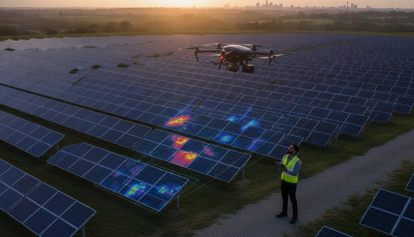
Relying on manual IV curve testing and ground-based inspections is no longer a sustainable strategy for maintaining utility-scale solar assets in 2026. You already understand that even a minor undetected string failure or a cluster of faulty bypass diodes can significantly compromise your annual energy yield. The traditional approach to site maintenance is often slow, prohibitively expensive, and introduces unnecessary health and safety risks to your technical teams on the ground.
This guide demonstrates how professional PV solar farm thermal surveys use high-resolution aerial thermography to pinpoint faults with centimetre-level precision. By transitioning to a data-driven inspection model, asset managers can identify issues that remain invisible to the naked eye. We’ll explore how IEC-compliant data collection and actionable fault reporting eliminate guesswork, streamline your maintenance workflows, and ensure your solar farm operates at its peak technical capacity. You’ll learn the specific methodologies required to secure maximum energy production while maintaining strict regulatory compliance across your entire UK portfolio. From identifying sub-module defects to verifying the integrity of entire strings, this approach provides the technical clarity needed to protect your long-term investment.
Key Takeaways
- Understand how modern O&M strategies integrate infrared sensors to detect temperature anomalies before they cause significant yield loss.
- Learn to categorise faults from cell hotspots to full string failures using PV solar farm thermal surveys, while identifying environmental issues like soiling or vegetation shading.
- Discover why aerial inspections are significantly more efficient than manual testing, allowing a 5MW farm to be surveyed in hours rather than days.
- Ensure your asset management meets UK industry standards by verifying CAA GVC certifications and the necessity of £5m commercial liability insurance.
- See how high-resolution thermal imaging hardware provides the precise thermal data needed for actionable maintenance reports and IEC-compliant documentation.
What are PV Solar Farm Thermal Surveys?
A professional thermal survey is a specialised diagnostic process involving Unmanned Aerial Vehicles (UAVs) equipped with high-resolution radiometric infrared sensors. These PV solar farm thermal surveys are designed to detect minute temperature anomalies across a photovoltaic power station that indicate underlying electrical or mechanical issues. While traditional ground-based inspections rely on the naked eye, thermal imaging reveals heat signatures that signify energy loss or potential component failure long before they become visible to a technician.
The role of aerial thermography has become a cornerstone of modern Operations and Maintenance (O&M) strategies. Relying solely on visual inspections is insufficient because internal electrical faults, such as bypass diode failures or micro-cracks, rarely show physical symptoms on the module surface. The rapid evolution of survey drone technology has transitioned these inspections from experimental procedures to essential, IEC-compliant industry standards in the renewable energy sector.
To better understand the technical precision involved in these inspections, watch this demonstration of high-resolution aerial thermography:
The Science of Thermal Imaging in Photovoltaics
Infrared sensors identify “hotspots” which are localised areas of high temperature caused by resistive heating. This occurs when a cell or module is no longer producing energy but is instead consuming it. For data to be technically valid, PV solar farm thermal surveys must be conducted under specific irradiance conditions, typically a minimum of 600W/m², to ensure the panels are under sufficient load. Accurate data also requires a meticulous understanding of emissivity; the glass surface of a solar panel can be highly reflective, so our pilots adjust flight angles to avoid “thermal glint” that could skew the results.
Why Regular Thermal Monitoring is Essential
Safety is the primary driver for consistent monitoring. Identifying overheating diodes and connectors early prevents catastrophic fire risks that could jeopardise the entire site. Beyond safety, thermal data provides objective evidence needed to validate manufacturer warranty claims. If a module is underperforming due to a manufacturing defect, a radiometric report is often the only proof accepted by suppliers. This proactive approach ensures you’re optimising energy yield by identifying non-performing strings early, protecting the long-term ROI of your UK energy portfolio.
Identifying Solar Faults: From Cell Hotspots to String Failures
Effective PV solar farm thermal surveys don’t just find heat; they categorise it into actionable data. We classify anomalies into four distinct levels: cell, multi-cell, module, and string faults. A single cell hotspot might indicate a micro-crack, while a full string failure usually suggests a disconnected cable or inverter issue. Distinguishing these from environmental factors like bird droppings, soiling, or vegetation shading is critical. These external factors create “false positives” that can distract maintenance teams if they aren’t correctly identified during the analysis phase.
Professional data collection involves both qualitative and quantitative analysis. Qualitative work involves scanning the site to identify anomalies, while quantitative analysis measures the specific temperature difference (Delta-T) between the fault and the surrounding healthy modules. This level of detail is why high-quality drone survey data is so valuable. It integrates seamlessly with asset management platforms, allowing O&M teams to track degradation over time. If you’re looking to enhance your site’s health monitoring, our team provides specialist solar thermography services across the UK.
Common Electrical Faults Detected
Bypass diode failures are among the most common issues we detect. When a diode fails, it can cause a third or even the entirety of a module to go offline, appearing as a distinct rectangular heat signature. String outages are even more severe. These occur when entire rows of panels are disconnected, often due to blown fuses or damaged cabling. We also look for Potential Induced Degradation (PID), which manifests as a “checkerboard” pattern of heat across panels near the negative pole of the string, indicating a significant loss in efficiency.
IEC 62446 Standards and Reporting
Adherence to IEC 62446-3:2017 is the gold standard for any commercial PV solar farm thermal surveys. This international standard dictates the environmental conditions and technical requirements needed for a valid report. We utilise high-resolution 640×512 thermal sensors to ensure every pixel provides accurate radiometric data, meeting the strict requirements for technical due diligence. Orthomosaic mapping creates a geometrically corrected, high-resolution map of the entire site that allows technicians to locate specific faulty modules with absolute geographical precision.
Drones vs. Traditional Inspections: ROI and Efficiency
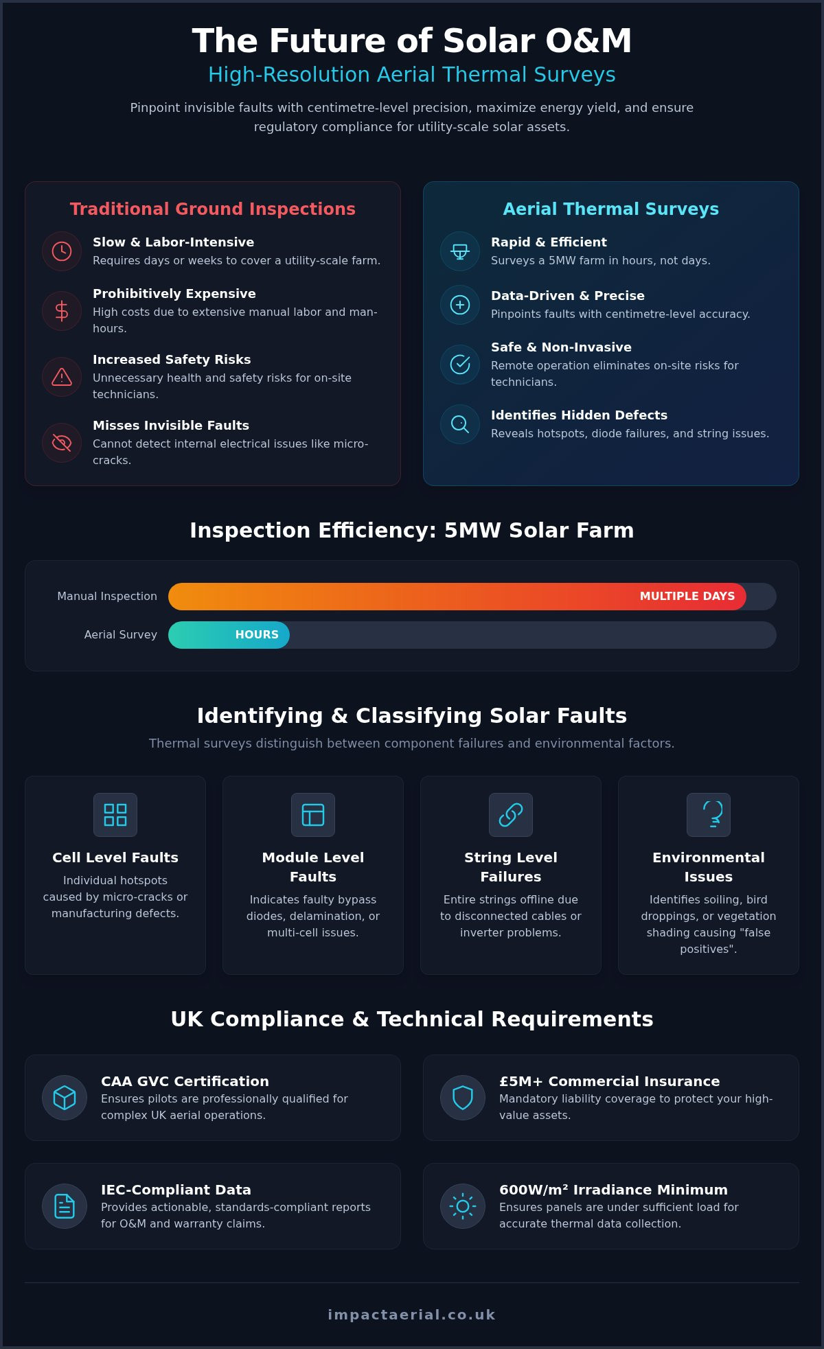
Traditional manual inspections are often a bottleneck in solar asset management. A ground team equipped with handheld thermal cameras might take several days to walk a 5MW site, often missing faults due to poor viewing angles or simple human fatigue. In contrast, professional PV solar farm thermal surveys can cover the same 5MW area in roughly two to three hours. This speed doesn’t just save on labour costs. It allows for inspections during the narrow windows of peak irradiance required for technically valid data.
The difference in data density is staggering. While manual teams perform spot-checks, a drone captures millions of radiometric data points across every module on the site. These non-contact inspections mean your system remains fully operational throughout the process. There’s no need for costly shutdowns or string isolations. Additionally, using electric UAVs for monitoring aligns perfectly with the sustainability goals of any renewable energy project, reducing the carbon footprint of the maintenance programme itself.
Cost-Benefit Analysis for Asset Managers
Calculating the payback period for a thermal survey is straightforward when you consider the cost of undetected energy loss. A single failed string can result in thousands of pounds in lost revenue over a single season. Early detection prevents these minor issues from escalating into catastrophic component failures or site fires. By moving inspections to the air, you also significantly reduce “Working at Height” risks and other ground-based hazards. This proactive safety stance, supported by our £5m commercial liability insurance, provides the reassurance required when managing high-value UK infrastructure.
Precision and Repeatability
Consistency is vital for long-term asset health. We use GPS-tagged data to ensure that every identified anomaly is tied to a specific coordinate. This allows for precise year-on-year performance tracking, making it easy to see if a minor hotspot is stable or degrading. The technical gap between DJI Enterprise sensors and budget handheld alternatives is significant; high-end hardware provides the thermal sensitivity needed to see through the “noise” of solar reflections. Automated flight paths ensure 100% site coverage by maintaining consistent overlaps and altitudes that human-controlled inspections simply cannot match.
UK Regulations: Navigating CAA Compliance in 2026
Compliance in the UK drone industry is no longer a grey area; it is a strict legal requirement that protects both the operator and the asset owner. In 2026, the Civil Aviation Authority (CAA) enforces rigorous standards for any commercial operation. A valid drone license is mandatory for pilots conducting PV solar farm thermal surveys. This certification ensures that the flight team understands the complexities of the UK’s congested airspace, particularly when operating near critical infrastructure, power lines, or restricted military zones often found near rural solar sites.
Managing flight permissions requires more than just technical skill. It demands a thorough understanding of the specific airspace around your facility. Meticulous flight planning and on-site risk assessments are the bedrock of our safety-first approach. We also maintain strict GDPR and privacy protocols to ensure that data collection remains focused solely on the solar asset, protecting the privacy of neighbouring landowners. For asset managers seeking a fully compliant partner, our Birmingham-based team provides accredited thermal inspection services across the West Midlands and the wider UK.
The Importance of CAA GVC Certification
The General Visual Line of Sight Certificate (GVC) is the professional standard for UAV operations in the UK. This qualification confirms that a pilot has been formally assessed on flight safety, meteorology, and emergency procedures. “Hobbyist” pilots or uncertified operators represent a massive liability risk for solar farm owners. Without a GVC, an operator is not legally permitted to fly the sophisticated DJI Enterprise hardware required for radiometric data collection. Using an uncertified pilot could potentially void your site’s operational insurance and leave you vulnerable to CAA enforcement action.
Insurance and Risk Mitigation
Standard public liability insurance is rarely sufficient for high-value energy infrastructure. We carry £5m commercial liability insurance that is specifically designed for professional UAV operations. This level of coverage is the industry standard for high-value assets, providing the financial reassurance that asset managers require. Professional indemnity insurance is also essential, as it protects the integrity and technical validity of the resulting survey reports. The UK regulatory landscape has now finalised the transition from PfCO to GVC standards, reflecting a more robust and professionalised approach to aerial data collection.
Impact Aerial: Specialist Solar Surveys in Birmingham and the UK
Impact Aerial operates as a high-end technical consultancy, providing specialised PV solar farm thermal surveys from our central hub in Birmingham. Our location in the West Midlands isn’t just a geographical detail; it’s a strategic advantage that enables rapid deployment to any site across the UK. We utilise the latest DJI Enterprise hardware, which allows us to capture dual-stream data: high-resolution radiometric thermal imagery alongside 4K HDR visual video. This combination ensures that every anomaly detected is cross-referenced with a visual high-definition record, making it easier to distinguish between internal electrical failures and external physical damage. Our comprehensive drone services are built on a foundation of CAA GVC certification and £5m commercial liability insurance, offering the technical reassurance that utility-scale asset managers require.
Our Process: Data Capture to Actionable Insights
Success begins long before the drone leaves the ground. Our meticulous process starts with site feasibility and irradiance window planning, ensuring that we only fly when conditions meet the minimum 600W/m² threshold required for accurate data. During the high-precision flight execution, our pilots use automated flight paths to maintain consistent overlaps and altitudes. This methodical approach guarantees 100% site coverage without gaps. Once the raw data is captured, it’s analysed by qualified thermographers who produce annotated technical reports. These documents don’t just list temperatures; they provide clear, actionable maintenance priorities that your ground teams can use to execute repairs immediately.
Why Choose a West Midlands Based Specialist?
The UK weather is notoriously unpredictable, making flexible scheduling essential for solar inspections. Being based in Birmingham allows us to monitor local weather patterns and deploy teams at short notice when optimal solar windows appear. We have a deep understanding of the local regulatory environments and complex UK airspace, ensuring every flight is fully compliant with the latest CAA standards. Unlike many providers who focus solely on raw data, we bridge the gap between technical thermography and professional visual documentation. We provide cinematic 4K visuals that are ideal for stakeholder presentations and annual health reviews, giving you a complete 360-degree perspective of your asset’s condition. This dual-purpose output ensures that you receive both the diagnostic data needed for O&M and the high-end visual assets required for corporate reporting.
Securing Your Solar Asset’s Future Performance
Transitioning to aerial thermography is no longer just a technical upgrade; it’s a strategic necessity for protecting your long-term energy yield. Professional PV solar farm thermal surveys provide the technical clarity needed to identify sub-module defects and string failures with absolute precision. By moving away from slow, manual inspections, you reduce site risk and ensure that your maintenance budget is focused exactly where it’s needed most. This data-centric approach doesn’t just improve efficiency; it validates warranty claims and secures the technical viability of your portfolio.
Our expert Birmingham-based technical team is ready to help you navigate the complexities of 2026 UK drone regulations. With CAA GVC certified pilots and £5m commercial liability insurance, we provide the professional reassurance required to operate on high-value infrastructure. Don’t leave your energy ROI to chance. Take the first step toward comprehensive site health monitoring by clicking below.
Request a PV Solar Farm Thermal Survey Quote today and ensure your panels are operating at peak technical capacity.
Frequently Asked Questions
Are drone thermal surveys legal for solar farms in the UK?
Yes, aerial inspections are entirely legal in the UK when conducted by a CAA-authorised operator. Commercial drone pilots must hold a General Visual Line of Sight Certificate (GVC) to fly sophisticated thermal hardware. We ensure all flights are conducted within the Specific Category framework, maintaining strict adherence to safety protocols and airspace permissions. This compliance provides asset managers with the legal reassurance required for utility-scale infrastructure projects across the country.
What is the best time of year to conduct a PV solar farm thermal survey?
The optimal period for PV solar farm thermal surveys is between April and September. This window provides the high solar irradiance levels, typically a minimum of 600W/m², necessary to put the panels under sufficient electrical load. Without high irradiance, thermal anomalies may not manifest clearly enough for accurate detection. We monitor weather patterns closely to ensure data is captured during these peak conditions to maintain strict technical validity.
Can a thermal drone detect faults that are not visible to the naked eye?
Yes, thermal sensors detect infrared radiation that is completely invisible to the human eye. While a module might look physically intact, the sensor identifies heat signatures caused by internal electrical resistance. This allows us to pinpoint bypass diode failures, micro-cracks, and Potential Induced Degradation (PID) that would otherwise remain undetected. Identifying these hidden faults early is essential for preventing yield loss and potential fire hazards across your entire solar site.
How much does a commercial PV solar farm thermal survey cost?
Pricing for a professional inspection depends on several variables, including the total megawatt (MW) capacity of the site and the specific reporting requirements. Factors such as site location, terrain complexity, and the depth of data analysis needed also influence the final investment. We provide bespoke quotes based on these technical parameters to ensure you receive a survey tailored to your asset’s specific operational needs and long-term maintenance goals.
Do I need to shut down the solar farm during the drone survey?
No, the solar farm must remain fully operational during the inspection. In fact, the panels need to be generating power and under significant load for thermal anomalies to be visible. If the system is shut down, the modules will cool, and electrical faults like hotspots or string failures will disappear from the thermal spectrum. This non-intrusive method allows for comprehensive site health checks without any interruption to your energy production.
What resolution thermal camera is required for IEC-compliant surveys?
To meet IEC 62446-3 standards, a thermal sensor with a minimum resolution of 640×512 pixels is required. This high-resolution hardware ensures that each pixel represents a specific radiometric temperature reading, providing the technical detail needed to distinguish between individual cell faults. Using lower-resolution sensors can result in blurred data, making it impossible to accurately categorise anomalies or provide the technical due diligence required by asset owners and insurers.
How long does it take to receive the final solar farm inspection report?
Delivery times for a final technical report typically range from five to ten working days after the flight is completed. This duration allows our thermographers to meticulously analyse the raw radiometric data, categorise every identified anomaly, and cross-reference them with high-definition visual imagery. Larger utility-scale sites may require additional processing time to ensure the orthomosaic mapping and annotated fault reports meet our strict internal quality and precision standards.
What is the difference between a qualitative and quantitative thermal survey?
A qualitative survey focuses on identifying the presence of thermal anomalies and categorising their patterns to find faults. A quantitative PV solar farm thermal survey goes further by measuring the specific temperature of the anomaly and comparing it to a healthy reference module. This temperature difference, known as Delta-T, is vital for assessing the severity of a fault and determining whether it requires immediate maintenance intervention or long-term performance monitoring.
 2 Norton Drive, Wythall, Birmingham, B47 6HH Company registration number: 11138586. VAT Number: 366 9068 55


