What if you could eliminate the single biggest health and safety risk on your site while cutting inspection downtime by more than 50%? Scaffolding is expensive. A standard commercial roof inspection can easily cost you £2,500 before the actual work even begins. You’re likely tired of incomplete ground-level data leaving gaps in your insurance documentation and creating unnecessary liabilities. It’s time for a more precise approach.
This professional guide explains how a drone survey for risk assessment provides high-resolution visual proof while keeping your team safely on the ground. The UK drone market reached $1.1 billion in 2025, and aerial data is now the primary method for high-stakes risk collection. We’ll break down the January 1, 2026, CAA regulation changes, including mandatory Remote ID and UK class marks, to ensure your site remains fully compliant. You’ll learn how to leverage 4K HDR imagery and photogrammetry to create a safer inspection process that delivers a measurable return on investment and total peace of mind for your next audit.
In this professional guide, you’ll learn:
- How the industry is moving away from dangerous manual “Work at Height” toward remote digital site inspections for superior hazard identification.
- The technical framework for 2026, including why CAA GVC certification and DJI Enterprise-grade hardware are non-negotiable for high-quality data gathering.
- A direct risk and cost comparison between UAV deployment and traditional scaffolding, which can cost upwards of £2,500 for a single commercial roof check.
- The step-by-step professional workflow for a drone survey for risk assessment, from initial desktop studies to on-site safety execution.
- Why Impact Aerial is the leading choice for UK safety surveys, providing added peace of mind through £5 million in liability insurance and meticulous regulatory compliance.
What is a Drone Survey for Risk Assessment?
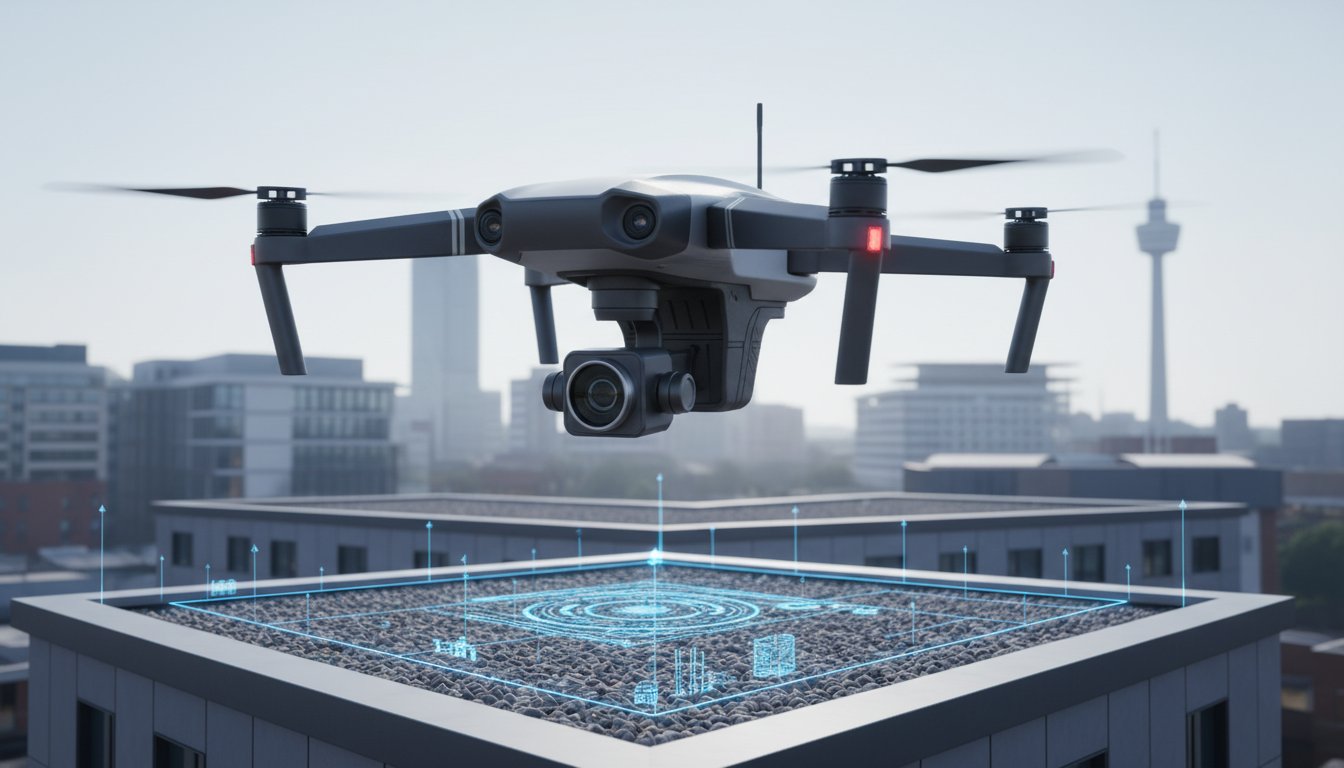
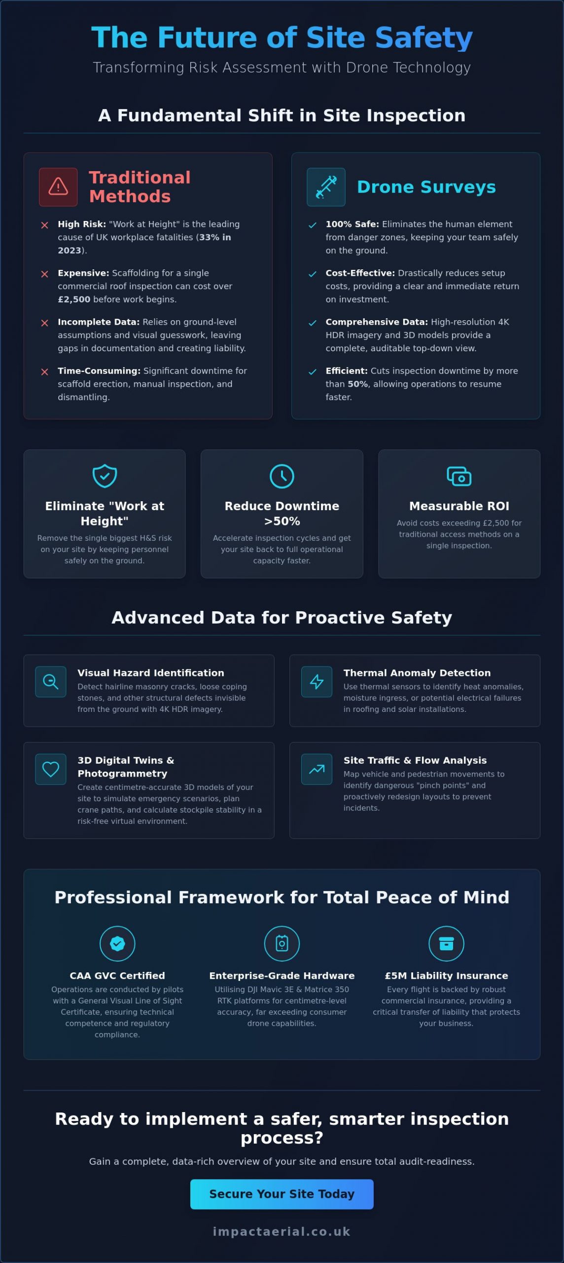
A drone survey for risk assessment is a methodical data-gathering process that uses Unmanned Aerial Vehicles (UAVs) to identify site hazards through high-resolution imagery and multi-spectral sensor data. This approach represents a fundamental shift from manual “Work at Height” inspections to remote digital site analysis. In the UK, falls from height remain the leading cause of workplace fatalities, representing 33% of all fatal injuries in 2023 according to HSE data. By deploying a drone, you remove the human element from the danger zone entirely. It’s a safer, faster, and more reliable way to audit complex environments.
This technology is now essential for construction, commercial property management, and industrial plant operations. Data captured during a drone survey for risk assessment integrates seamlessly into modern Risk Assessment Method Statements (RAMS). Instead of relying on ground-level assumptions, site managers gain a comprehensive top-down view of their assets. This methodology aligns with the growing diversity of drone applications across global industries, where precision data is replacing visual guesswork.
To better understand how these assessments are structured, watch this helpful video:
Visual Hazard Identification from Above
Aerial perspectives reveal structural defects like hairline masonry cracks or loose coping stones that ground-level checks miss. For industrial clients, thermal sensors identify heat anomalies in PV solar farms or moisture ingress within complex roofing systems that could lead to electrical failure or structural collapse. We also use high-cadence imagery to map site traffic and pedestrian flow. This allows logistics managers to identify dangerous “pinch points” where heavy machinery and workers intersect, allowing for proactive layout changes before an incident occurs.
The Role of Photogrammetry in Safety Planning
Safety planning is transformed by 3D digital twins generated through photogrammetry. These high-fidelity models allow safety officers to simulate emergency scenarios, such as fire evacuation or hazardous spill containment, in a risk-free virtual environment. By using professional survey drones, teams achieve centimetre-level accuracy in their topographical safety analysis. This level of precision is vital when calculating crane swing paths or determining the stability of embankments and stockpiles. It ensures that every safety barrier and exclusion zone is placed with mathematical certainty.
The Technical Framework: CAA Compliance and Data Quality
Compliance isn’t just a legal checkbox; it’s a critical transfer of liability that protects your business. A professional drone survey for risk assessment demands more than a basic flyer. It requires an operator holding a CAA GVC (General Visual Line of Sight Certificate). This certification proves the pilot has the technical competence to operate heavy, sophisticated machinery in complex environments. When we conduct a survey, we don’t just fly. We provide a robust audit trail that satisfies both the Civil Aviation Authority and your insurance underwriters.
The quality of your safety data depends entirely on the hardware used. We utilise DJI Enterprise-grade drones, such as the Mavic 3 Enterprise and Matrice 350 RTK. These platforms offer RTK (Real-Time Kinematic) positioning, providing centimetre-level accuracy that consumer drones can’t match. This precision is vital when you’re measuring structural shifts or mapping hazardous terrain. For added peace of mind, every flight we conduct is backed by £5 million in commercial liability insurance, ensuring your site is protected against even the most unlikely scenarios. For those looking to secure their site, a professional aerial inspection ensures every technical detail is handled by experts.
Data security is another non-negotiable pillar of our framework. Capturing high-resolution imagery of sensitive infrastructure like power plants or commercial hubs requires strict data handling protocols. We employ end-to-end encryption and secure UK-based storage to manage your site safety imagery. This ensures that your proprietary data remains confidential and accessible only to authorised personnel for your internal risk audits.
UK Drone Laws for Site Surveys in 2026
Significant changes to UK drone laws came into force on January 1, 2026. All new drones placed on the market must now carry a UK class mark, ranging from UK0 to UK6. Operating in congested urban areas requires a specific drone license and adherence to Remote ID broadcast requirements. We manage all flight permissions and restricted airspace clearances through the CAA, implementing physical cordons and safety marshals to maintain a sterile working area during every deployment.
Sensors and Payloads for Safety Data
Our fleet uses 4K HDR sensors to capture every minute detail of cladding, masonry, and weld points. Thermal imaging payloads are deployed to detect fire risks or heat leakage in industrial roofing that the naked eye misses. By using high-powered optical zoom, we maintain a safe standoff distance from hazards like high-voltage lines or unstable structures. This capability allows us to gather “close-up” data without ever putting the aircraft or your personnel at risk.
Drones vs. Traditional Access: A Risk and Cost Comparison
Traditional access methods like scaffolding or Mobile Elevating Work Platforms (MEWPs) are inherently risky and resource-heavy. While a manual roof check might take days to coordinate, a drone survey for risk assessment can be deployed in under an hour. This speed doesn’t just save time; it fundamentally changes the nature of site safety. Instead of a human inspector navigating a fragile roof with a clipboard, a pilot captures every millimetre of the structure from the safety of the ground. It’s a meticulous approach that replaces high-altitude danger with precision technology.
The depth of data also shifts from subjective to objective. Manual inspections often result in inconsistent notes and a handful of low-resolution photos taken from awkward angles. Aerial surveys provide a comprehensive digital record. You get 4K visual proof and multi-spectral data that can be re-examined by multiple stakeholders without ever re-visiting the site. This eliminates the “human error” factor from hazard identification, providing a definitive audit trail for insurance and compliance purposes that traditional methods simply can’t match.
Safety ROI: Reducing On-Site Accidents
Health and Safety Executive (HSE) data for 2023 confirms that falls from height remain the single biggest cause of workplace fatalities in the UK. This creates a massive liability for site operators. Remote inspections keep your staff safely on the ground, effectively reducing “Work at Height” hours to zero for the duration of the inspection. This is particularly vital after extreme weather events. In the wake of early 2026’s storm damage, drones allowed for immediate structural assessments while conditions were still too dangerous for manual climbing. This proactive approach provides added peace of mind for site managers facing high-stakes decisions.
Operational Efficiency and Downtime
One of the most significant business advantages is the lack of site disruption. Setting up heavy access machinery often requires cordoning off large sections of a facility, halting operations for days at a time. A professional drone survey allows work to continue uninterrupted below the flight path. In a recent commercial project, a roof inspection that typically required three days of scaffolding preparation was completed in just four hours. Beyond time savings, the carbon footprint of a battery-powered UAV is negligible compared to the logistics of transporting heavy plant machinery. In a niche but increasingly diverse market, these efficiencies are becoming the standard for modern industrial plant management.
Planning Your Survey: From Desktop Study to Site Safety
A successful drone survey for risk assessment depends entirely on the preparation that happens before the aircraft ever leaves the ground. We follow a meticulous workflow designed to eliminate operational surprises and ensure complete data accuracy. This process isn’t just about flying; it’s a structured methodology that integrates with your existing health and safety frameworks. By following these five essential steps, we ensure every flight is safe and every data point is actionable:
- Step 1: Consultation to define safety objectives and specific data requirements.
- Step 2: Comprehensive desktop study covering NOTAMs and airspace constraints.
- Step 3: On-site physical risk assessment and a safety briefing for your site staff.
- Step 4: Precision data capture with real-time monitoring available for stakeholders.
- Step 5: Professional analysis and delivery of a secure, high-resolution digital audit trail.
Our Birmingham-based team handles every logistical detail, from coordinating with local authorities to establishing safe takeoff and landing zones. If you’re ready to upgrade your site safety protocols with a compliant workflow, contact us for a professional consultation today.
The Desktop Study: Identifying Constraints
The desktop study is where we identify potential flight hazards using the latest January 2026 airspace data. We check “Notices to Airmen” (NOTAMs) to ensure no temporary flight restrictions are in place near your site. Our pilots review detailed site maps to locate overhead power lines, high-frequency radio towers, and other obstacles that could interfere with DJI Enterprise hardware. We also coordinate with local building managers and, if necessary, the Civil Aviation Authority (CAA) to secure permissions for flights in restricted UK airspace. This phase ensures that on the day of the survey, the flight is a routine execution of a pre-vetted plan.
Post-Flight Data Analysis
Capturing raw footage is only half the task. The real value lies in how that data is processed into actionable safety intelligence. We use professional post-production services to highlight specific risks, such as hairline fractures in masonry or thermal leaks in roofing. By applying digital overlays and annotations, we turn complex aerial imagery into a clear, easy-to-digest report. All data is delivered via secure, encrypted cloud portals. This allows your stakeholders to review high-resolution proof from any device, providing the transparency needed for high-stakes risk management decisions.
Impact Aerial: Professional UAV Risk Data Solutions
Based in Birmingham and the West Midlands, Impact Aerial has established itself as a trusted specialist for high-stakes site inspections across the UK. We don’t just fly drones; we provide a technical consultancy service that prioritises regulatory adherence and data precision. In a niche but increasingly diverse market, our team stands out by offering a meticulous approach to every drone survey for risk assessment. We understand that your business reputation depends on the accuracy of your safety data. That’s why we leave nothing to chance, ensuring every flight delivers the high-quality visual proof required for rigorous insurance audits.
Reliability is built into our operational DNA. Every project we undertake is supported by £5 million in commercial liability insurance and full CAA GVC certification. This isn’t just about meeting legal requirements; it’s about providing for added peace of mind. We take the operational burden off your shoulders by managing all regulatory hurdles, including the January 2026 Remote ID requirements and UK class mark compliance. Our goal is to ensure your site remains safe, your audits are foolproof, and your insurance premiums are protected by high-resolution proof that ground-level checks simply can’t provide.
Our Fleet and Expertise
Our fleet consists of the latest DJI Enterprise commercial drones, specifically chosen for their ability to deliver top-quality results in the unpredictable UK climate. These aircraft are equipped with redundant systems and high-precision sensors that ensure stable data-gathering even in challenging industrial environments. Our pilots aren’t just technologically adept; they are site-safety trained professionals who understand the nuances of construction and property management. We offer a leading range of drone services tailored to the specific needs of commercial property developers and building service providers nationwide.
Next Steps: Book Your Safety Survey
Integrating aerial data into your existing safety workflow is a seamless process with our team. We provide raw data and processed reports that fit directly into your Risk Assessment Method Statements (RAMS). If you’re managing a complex or high-risk location, our consultation process includes a detailed feasibility study to ensure the safest flight paths and most effective data capture points. This methodical approach has made us a preferred partner for industrial plant managers who demand a clear return on investment and reduced site downtime.
Ready to eliminate the dangers of working at height and secure superior data for your next audit? Contact Impact Aerial today to request a bespoke quote for your drone survey for risk assessment. We’ll walk you through the technical requirements and help you build a safer, more efficient inspection strategy for 2026 and beyond.
Future-Proofing Your Site Safety Strategy
The transition from high-risk manual inspections to a digital-first approach is now the industry standard for 2026. By adopting a drone survey for risk assessment, your business effectively eliminates the dangers of “Work at Height” while securing high-resolution proof for insurance audits. We’ve explored how professional hardware and strict CAA GVC compliance provide a level of data depth that traditional scaffolding simply cannot match. It’s about more than just pictures. It’s about building a robust, defensible audit trail for your site.
Impact Aerial provides the technical expertise and regulatory peace of mind you need. Our team operates a leading fleet of enterprise-grade DJI drones and carries £5 million in commercial liability insurance for every deployment. With expertise in UK-wide property and construction surveys, we deliver the precision data required to keep your operations running smoothly. Ready to upgrade your safety protocols? Request a Professional Drone Survey Quote for Your Site and let our certified pilots handle the technical details. We look forward to helping you achieve a safer site inspection process.
Frequently Asked Questions
Is a drone survey legal for commercial risk assessments in the UK?
Yes, conducting a drone survey for risk assessment is fully legal provided the operator holds a valid CAA GVC (General Visual Line of Sight Certificate). As of January 1, 2026, all commercial drone operations must also comply with new UK class marking and Remote ID broadcast requirements. We handle all regulatory filings and flight permissions to ensure your site remains compliant with the latest Civil Aviation Authority standards.
How much does a drone survey for risk assessment cost?
Costs are determined by the project’s scale and the specific technology required for data capture. Verified 2026 industry data shows that commercial roof inspections generally range between £1,100 and £2,500, while construction site surveys typically cost from £600 to over £2,000. For more advanced requirements, such as LiDAR or thermal mapping, prices can start at £1,500 and exceed £5,000 depending on the site’s complexity.
What kind of data will I receive after the drone survey?
You’ll receive a comprehensive digital audit trail that includes high-resolution 4K HDR imagery and detailed video footage. Depending on your survey objectives, we also provide thermal maps for identifying heat anomalies and 3D digital twins for structural analysis. All data is processed through our post-production workflow and delivered via a secure cloud portal for easy sharing with your insurance or audit teams.
Can drones be used for risk assessments in windy or rainy conditions?
Enterprise drones are designed for reliability in various UK weather conditions, but safety is always our priority. Our DJI Matrice fleet carries an IP55 rating for moisture resistance and can maintain stable flight in winds up to 12 metres per second. If conditions exceed these specific technical thresholds, we’ll reschedule the flight to ensure both site safety and the highest possible data quality.
Do I need to inform the CAA before you fly over my site?
No, you don’t need to manage any communication with the regulator. As part of our professional service, we handle all coordination, including checking NOTAMs and securing permissions for restricted UK airspace. We manage the entire logistical process, from initial flight planning to local authority liaison, so you can focus on your core site operations without administrative delays.
How does a drone survey compare to traditional scaffolding for inspections?
A drone deployment is significantly faster and more cost-effective than traditional access methods. Scaffolding can take days to install and often costs upwards of £2,500 for a standard commercial roof check, whereas a drone can complete the same task in a few hours. Most importantly, it removes the “Work at Height” risk entirely, keeping your personnel safely on the ground throughout the inspection.
What insurance coverage does Impact Aerial provide for site surveys?
We provide £5 million in commercial liability insurance for every project we undertake. This specific coverage is a cornerstone of our commitment to safety and provides added peace of mind for our clients. We include full insurance certificates and pilot credentials in the pre-flight safety pack we deliver before arriving on your site.
How long does a typical drone risk assessment survey take to complete?
Most on-site data capture sessions for a drone survey for risk assessment are completed within 2 to 4 hours. While the flight time is brief, the meticulous planning and post-flight analysis ensure total accuracy. Once the site work is finished, our team typically delivers the final processed reports and high-resolution imagery within 48 hours.
