
Traditional scaffolding and cherry pickers are no longer the gold standard for structural surveys; they are often an unnecessary financial and safety burden. As we move through 2026, the industry is shifting toward precision stand-off tools that deliver microscopic detail without the proximity risk of traditional flights. Utilizing professional drone zoom inspection services UK wide allows asset managers to capture millimetre-accurate data from a safe distance. This approach eliminates the need for personnel to work at height while providing a level of visual clarity that was previously impossible from the ground.
It’s understandable if you’re skeptical about whether a remote camera can truly replace a physical hands-on inspection. You need to see hairline cracks, corroded bolts, or faded serial numbers to make informed maintenance decisions. This article explores how advanced DJI Enterprise hardware and CAA GVC certified pilots provide ultra-high-resolution inspection data that meets strict regulatory standards. We’ll preview the latest 2026 compliance requirements, the cost-saving benefits of reduced downtime, and how high-resolution zoom technology ensures your asset reporting remains fully insured and audit-ready.
Key Takeaways
- Learn how high-magnification optical sensors allow for detailed structural analysis without the risks associated with close-proximity flights or manual access.
- Discover how professional drone zoom inspection services UK wide provide millimetre-accurate visual data for identifying hairline cracks and serial numbers on critical infrastructure.
- Understand the specific advantages of zoom-led surveys for high-rise facade inspections and complex utility monitoring in the property and construction sectors.
- Identify the essential regulatory requirements for 2026, including the necessity of CAA GVC certification and comprehensive £5m commercial liability insurance for site safety.
- Explore the transition from raw aerial imagery to actionable reporting through professional post-production and consultative project management.
The Evolution of Industrial Asset Inspection in the UK
Industrial asset management has undergone a fundamental shift in how we approach structural integrity. For decades, inspecting high-rise facades or critical infrastructure meant weeks of logistical planning for scaffolding or rope access. By 2026, the reliance on these cumbersome methods has diminished as Unmanned Aerial Vehicles (UAVs) have reached a new level of operational maturity. 2026 represents a turning point where drone autonomy and sensor resolution have converged. Automated flight paths and AI-assisted zoom now allow for repeatable, high-precision data capture that was previously impossible. Professional drone zoom inspection services UK wide now offer a safer, more efficient alternative that meets the rigorous demands of modern engineering sign-offs.
Why Traditional Access is Becoming Obsolete
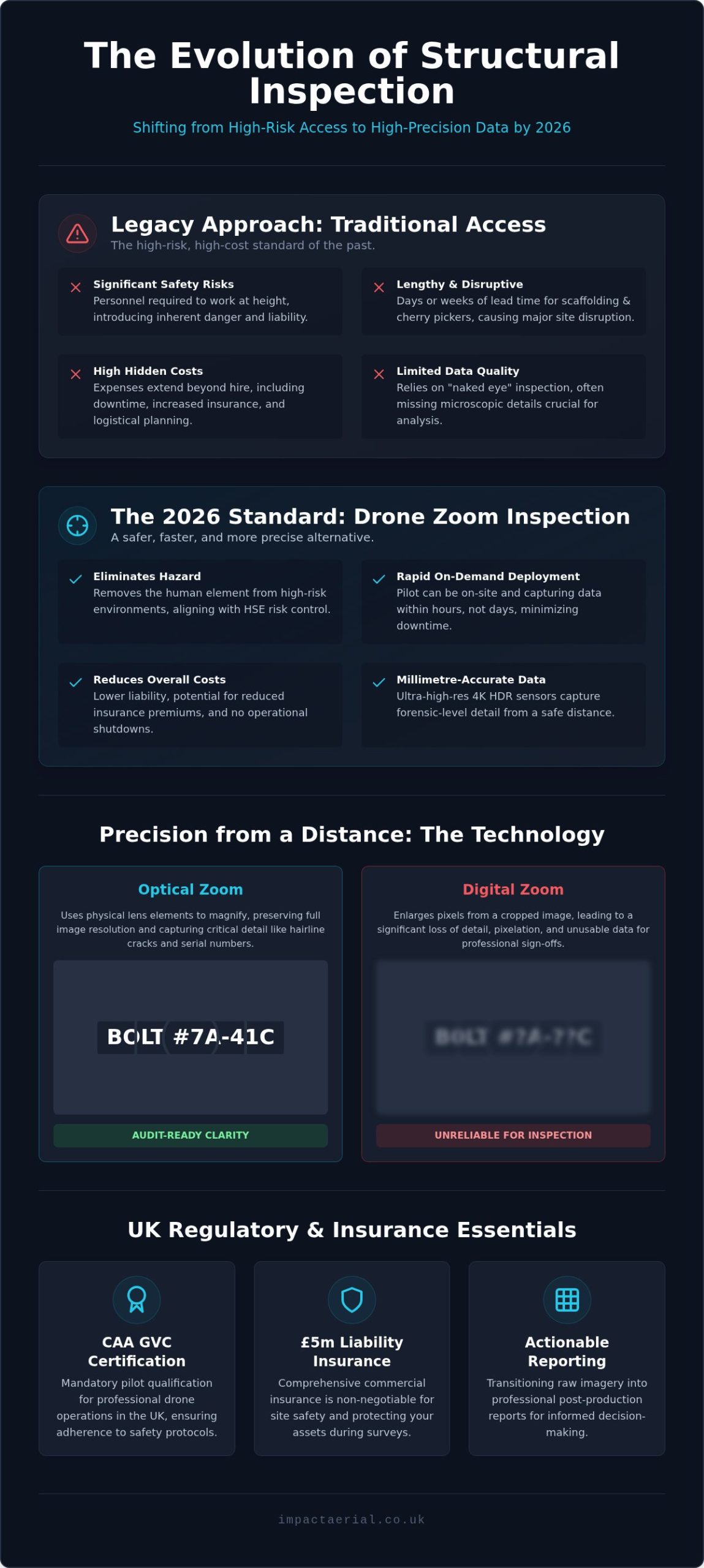
Traditional access methods involve heavy hidden costs that extend far beyond the initial hire quote. Scaffolding requires lengthy lead times, creates significant site disruption, and introduces the inherent risks of working at height. The UK Health and Safety Executive (HSE) prioritizes the elimination of hazards through its hierarchy of risk control. Drones fulfill this requirement by removing the human element from high-risk environments entirely. This transition lowers liability and can reduce insurance premiums for site owners. Deployment is now on-demand. Instead of waiting days for a cherry picker, a CAA GVC certified pilot can be on-site capturing data within hours. This agility reduces inspection downtime, allowing for a rapid response to suspected structural failures or routine maintenance checks without halting site operations.
The Role of High-Resolution Imagery in Modern Surveying
Modern surveying has moved beyond standard photography into the era of forensic-level data. The adoption of 4K HDR sensors on DJI Enterprise hardware allows for structural sign-offs that are as reliable as a physical “hands-on” inspection. These sensors capture microscopic details, such as hairline cracks or corroded fasteners, from a safe stand-off distance. This high-resolution output isn’t just a standalone file. It’s a vital component of digital twins and Building Information Modelling (BIM) models. In 2026, the integration of aerial data into these digital platforms allows for sophisticated predictive maintenance. Using drone zoom inspection services UK ensures that every pixel provides a clear, audit-ready trail of an asset’s condition. This data-centric approach provides a level of precision that traditional “naked eye” inspections simply cannot match, especially when dealing with hard-to-reach areas of a property or construction site.
Understanding Drone Zoom Technology: Precision from a Distance
Drone zoom technology is a specialized field within aerial surveying that prioritizes stand-off capabilities. This method utilizes high-magnification optical sensors to capture minute details from a distance, rather than flying the aircraft within centimeters of an asset. This Safe Distance principle is critical when inspecting sensitive infrastructure like live telecommunications towers or fragile historic masonry where proximity introduces unnecessary turbulence or collision risk. Professional drone zoom inspection services UK providers use these advanced optics to maintain a secure flight path while delivering millimetre-accurate visual data.
Maintaining a steady shot at high magnification is a significant technical challenge. Professional-grade gimbals use three-axis stabilization to counteract wind gusts and vibration, ensuring that even at maximum zoom, the image remains rock-steady. Without this mechanical precision, high-magnification shots would be too blurred for professional reporting. Using commercial-grade DJI Enterprise drones ensures that every frame of your survey is usable data for your structural engineers.
Optical vs. Digital Zoom for Inspections
For structural sign-offs, the distinction between optical and digital zoom is vital. Digital zoom essentially crops and enlarges an image, which often leads to pixelation and the loss of critical detail like hairline cracks. Optical zoom uses the physical movement of lens elements to increase magnification, maintaining full 4K resolution at significant distances. In the context of the UK’s Drone and Model Aircraft Code, stand-off distance refers to the safety buffer maintained between the aircraft and an object to ensure operational safety while complying with legal separation requirements. High-quality optical sensors ensure that even at 30x magnification, the imagery remains sharp enough for forensic engineering analysis.
Hardware Focus: DJI Enterprise Capabilities
The deployment of DJI Enterprise hardware has redefined the possibilities of portable zoom inspections. The DJI Mavic 3 Enterprise series, for example, offers a 56x hybrid zoom capability that allows pilots to identify defects from over 50 meters away. For more complex utility and solar assets, the DJI Matrice 30T provides dual-sensor capabilities, combining a 16x optical zoom with high-resolution thermal imaging. This allows for the simultaneous detection of structural cracks and thermal anomalies like hot spots in PV panels. These drones also feature integrated laser range finders, which are essential for repeatability. By recording the exact distance and coordinates of a defect, surveyors can return months later to monitor the same point for signs of degradation. If you’re managing a large portfolio of assets, our drone commercial property surveys provide the technical precision needed for long-term monitoring.
Key Applications: Where Zoom Inspections Deliver Maximum Value
High-magnification sensors have transformed how we assess vertical and high-value assets. In high-rise facade inspections, drone zoom inspection services UK wide allow for the identification of loose masonry and seal failures that are invisible to the naked eye. This forensic level of detail is equally critical for infrastructure monitoring. Bridges, pylons, and cell towers require regular structural checks to ensure public safety and operational continuity. By using optical zoom, we can verify the condition of rivets, bolts, and insulators without needing to climb or power down high-voltage equipment.
Solar farm maintenance is another area where high-resolution zoom provides a significant competitive edge. While thermal imaging identifies heat signatures, visual zoom is necessary to spot physical micro-cracks or debris on PV panels that could lead to long-term degradation. All operations are conducted in strict accordance with UK Civil Aviation Authority (CAA) regulations, ensuring that data collection is both legal and safe. This meticulous approach to data capture ensures that every survey meets the high standards required for engineering sign-offs and long-term asset management.
Commercial Property & Roof Surveys
Roof inspections often present the highest risk and cost for property managers. Using high-resolution zoom, we can identify “dead” gutters, blocked drainage points, and minor roof leaks without the need for risky roof walking. This provides insurance-grade documentation that is essential for property transactions and dilapidation claims. Our comprehensive drone property surveys bridge the gap between raw aerial imagery and professional structural reporting, giving stakeholders the clarity needed for capital expenditure planning. It’s a reliable way to get eyes on an asset without the setup time of traditional access.
Construction Site Monitoring & Safety
On active construction sites, verifying the integrity of welds and fixings at height is a constant challenge. High-magnification drones allow for real-time verification of structural integrity during the build phase. This capability significantly reduces the need for site-wide shutdowns or the deployment of heavy access machinery. Integrating construction site monitoring into your project management workflow ensures that quality control is maintained without compromising the build schedule. It’s about providing actionable data that keeps the project moving safely and on budget.
Why Safety & Certification are Non-Negotiable in the UK
Operating a drone for industrial purposes is a highly regulated professional service that requires significantly more than basic flight skills. In the complex environments of construction and infrastructure, safety is the primary metric of success. Professional drone zoom inspection services UK providers must adhere to strict operational limits to protect people, property, and the integrity of the data collected. For those responsible for the safety of recreational infrastructure, you can learn more about specialized sports facility equipment and surfacing inspections. This begins with a thorough understanding of the legal framework and ends with a meticulous approach to every flight, ensuring that all risks are identified and mitigated before the aircraft leaves the ground.
The General Visual Line of Sight Certificate (GVC) is the professional standard for commercial drone pilots in the UK. Unlike hobbyist flyers or those operating under basic authorizations, GVC certified pilots have undergone rigorous theoretical and practical assessments approved by the Civil Aviation Authority. This certification is essential for operating in the “Specific Category,” allowing for complex missions in congested areas or near sensitive infrastructure. Professional pilots are trained to manage complicated airspace, coordinating with Air Traffic Control when working near airports or within restricted city centres. Understanding the nuances of a UK drone license ensures that your project remains fully compliant with 2026 aviation laws, avoiding the heavy fines and legal liabilities associated with unauthorized flights.
Insurance & Risk Mitigation
For any industrial or commercial site, standard public liability insurance is insufficient. Professional drone operators carry specialist commercial UAV insurance that complies with EC 785/2004 requirements. We maintain £5m in commercial liability insurance as a baseline for all UK operations, providing the financial protection necessary for high-value asset inspections. Beyond financial coverage, our risk mitigation strategies include strict hardware failure protocols and pre-flight “fly-away” risk assessments. Impact Aerial provides site managers with the peace of mind that every flight is backed by meticulous planning, comprehensive insurance, and a total commitment to zero-incident operations. This disciplined approach ensures that our presence on your site is a benefit, not a liability.
Data protection is a critical yet often overlooked component of aerial surveying. Handling high-resolution imagery of public spaces or private assets requires strict adherence to GDPR and data privacy laws. We conduct Privacy Impact Assessments for every project, ensuring that any captured identifiable data is handled, stored, and deleted according to legal requirements. If you require a safety-first partner for your next structural survey, book our professional drone services to ensure your project is handled with the highest level of technical and legal expertise.
Partnering with Impact Aerial for Your UK Inspection Projects
Partnering with a specialist for drone zoom inspection services UK ensures that your structural data is captured and managed with technical precision from inception to delivery. Impact Aerial operates as a technical consultant rather than a simple flight agency. We understand that high-resolution imagery is only valuable if it’s actionable, compliant, and integrated into your existing maintenance workflows. Our team handles the entire project lifecycle, providing a seamless transition from raw aerial data to professional engineering reports that stand up to audit and insurance scrutiny.
Our consultative approach begins with a deep understanding of your specific asset requirements. We don’t just provide a pilot; we provide a full project management team that prioritizes safety and data integrity. This meticulousness is what sets us apart in the expanding market for drone zoom inspection services UK. By focusing on high-tier quality and adherence to strict professional standards, we ensure that every pixel of data we deliver serves a clear business purpose for your stakeholders.
The Impact Aerial Workflow
Our methodical approach ensures that every project meets our high standards for safety and precision. We follow a structured three-step process designed to minimize risk and maximize data quality:
- Step 1: Desktop Feasibility and Airspace Check: Before any hardware is deployed, we conduct a comprehensive analysis of the site. This includes checking for airspace restrictions, identifying ground hazards, and ensuring all operations will be fully compliant with CAA regulations and local bylaws.
- Step 2: On-site Execution: Using commercial-grade DJI Enterprise hardware, our pilots capture high-magnification optical data from safe stand-off distances. This phase is conducted with minimal site disruption, allowing your operations to continue while we gather forensic-level imagery.
- Step 3: Data Processing and Secure Delivery: Raw 4K HDR imagery is processed through our professional post-production suite. We turn high-resolution files into organized, actionable reports that highlight specific defects like hairline cracks or corrosion, ensuring your team has the clarity they need for structural sign-offs.
Ready to Elevate Your Inspections?
Based in our Birmingham hub, Impact Aerial is perfectly positioned to serve the West Midlands and provide rapid deployment across the entire UK. Our central location allows us to reach major infrastructure and construction hubs efficiently, ensuring your inspection timelines are met without delay. We offer bespoke quotes tailored to the technical requirements of your asset, whether you manage a single commercial property or a national portfolio of utility sites. Our commitment to reliability and compliance provides the reassurance that your assets are in safe, expert hands. Request a professional drone zoom inspection from Impact Aerial to secure the high-resolution data your project demands.
Securing the Future of Your Industrial Assets
The transition to high-resolution aerial data marks a definitive end to the era of expensive, high-risk manual access. By leveraging drone zoom inspection services UK wide, asset managers can now obtain millimetre-accurate visual data without the logistical burden of scaffolding or site shutdowns. We’ve explored how advanced optical sensors and stabilized gimbals deliver forensic-level clarity from a safe distance; this ensures that your structural sign-offs are backed by undeniable evidence. Compliance remains the cornerstone of professional operations, with 2026 regulations demanding a meticulous approach to airspace and data privacy.
Impact Aerial is ready to support your next project with our team of CAA GVC Certified Pilots, £5m Commercial Liability Insurance, and the latest DJI Enterprise Hardware. We handle everything from desktop feasibility to high-end post-production, turning raw imagery into actionable intelligence. Book a Professional Drone Zoom Inspection with Impact Aerial to ensure your assets are monitored with technical excellence and total regulatory peace of mind. We look forward to helping you elevate your site safety and data precision.
Frequently Asked Questions
What is the maximum zoom range for a professional inspection drone?
Professional inspection drones like the DJI Matrice 30T offer a 16x optical zoom and up to 200x digital magnification. The compact DJI Mavic 3 Enterprise features a 56x hybrid zoom capability. These ranges allow pilots to capture high-resolution data from a safe stand-off distance. Using such advanced hardware ensures that fine details are visible without flying the aircraft dangerously close to sensitive infrastructure or high-voltage equipment.
Can drone zoom inspections identify hairline cracks in concrete?
Yes, drone zoom inspection services UK providers use 4K HDR sensors and high-magnification optical lenses to detect hairline cracks as small as a millimetre. The stability provided by three-axis gimbals on DJI Enterprise hardware ensures that these images are sharp and forensic in quality. This level of detail is essential for structural engineers who need to sign off on the integrity of bridges, facades, or industrial chimneys without manual rope access.
Is a drone inspection legal in a congested UK city centre?
Drone inspections in UK city centres are legal when conducted by CAA GVC certified pilots who adhere to strict safety protocols. These operations require detailed flight planning and risk assessments to manage complex airspace and public safety. Impact Aerial pilots are trained to coordinate with local authorities and Air Traffic Control where necessary. Holding £5m commercial liability insurance is a standard requirement for operating in these high-density urban environments.
How much does a drone zoom inspection service cost in the UK?
The cost of a professional drone survey depends on the project’s complexity, site location, and the specific data requirements. Factors such as the need for specialized sensors, the duration of the flight, and the depth of post-production reporting all influence the final quote. We provide bespoke pricing based on a technical consultation to ensure the service matches your asset’s needs. This tailored approach guarantees you receive the most efficient and cost-effective data collection strategy.
Do I need to be present on-site during the drone inspection?
You don’t need to be present on-site during the inspection. Our pilots handle all aspects of the flight, from the initial airspace check to the final data capture. However, having a site representative available can be beneficial for providing access to specific areas or clarifying survey priorities. We provide full project management and can deliver the final high-resolution reports and imagery through secure digital platforms once the survey and post-production are complete.
What kind of report will I receive after the drone survey?
After a drone zoom inspection services UK survey, you’ll receive a comprehensive data package. This typically includes high-resolution 4K HDR imagery, stabilized video footage, and a detailed inspection report. Our post-production team processes raw data to highlight specific defects or areas of concern. These reports are designed to be actionable for structural engineers and property managers, often integrating directly into digital twins or Building Information Modelling (BIM) systems for long-term tracking.
Can drones perform zoom inspections in wet or windy weather?
Modern enterprise drones like the DJI Matrice 30T have an IP55 rating, which allows them to operate in light rain and dusty conditions. However, high winds can affect the stability of zoom shots and overall flight safety. We monitor weather forecasts closely and will reschedule a flight if conditions exceed the safe operating limits of the aircraft. Prioritizing safety ensures that the data collected is of the highest quality and that the mission remains fully insured.
How does zoom technology improve safety for solar farm inspections?
Zoom technology allows pilots to inspect PV panels from a significant height or distance, removing the risk of the drone colliding with sensitive equipment. By using high-magnification sensors, we can spot physical micro-cracks or debris without flying low over the arrays. This stand-off capability is particularly effective when combined with thermal sensors to identify hot spots. It ensures a comprehensive survey of the solar farm while maintaining a safe operating buffer from the ground and infrastructure.
 2 Norton Drive, Wythall, Birmingham, B47 6HH Company registration number: 11138586. VAT Number: 366 9068 55


