
A site can look straightforward from street level, while its boundaries and constraints remain difficult to assess. Aerial photography for urban regeneration schemes provides a wider view of tree canopies, property boundaries, pavement markings and small building additions. It helps teams understand how a site connects with its surroundings and identify where access or design issues need closer attention.
That perspective is useful when regeneration plans must respond to existing buildings, green space and the movement of people and vehicles. Images are most useful when their clarity and coverage match the decisions at hand, not simply when they show the largest possible area.
This article explains what aerial photography can reveal during a site review, how it can support the assessment of access and physical constraints, and why image resolution and geographic coverage matter. It also explains how aerial imagery complements other site information, helping you judge what it can show and where further survey work may be needed.
Key Takeaways
- Use aerial views to examine how boundaries, tree canopies and surrounding features relate to the regeneration site.
- Assess visible access routes and surface constraints, while recognising that aerial images complement rather than replace utility and environmental information.
- Match image detail to the task: broad views help with context, while higher-resolution imagery supports closer site assessment.
- Choose geographic coverage that reflects the decision at hand, from an individual development parcel to wider-area change.
Assessing site boundaries, vegetation and surrounding features
An overhead view shows how a regeneration site relates to nearby streets and buildings. Look for boundary walls, fences, pavement markings and small building additions, then compare their positions with the proposed site outline. Tree canopies can indicate where vegetation may affect layouts or visibility. These visible features help build a practical picture, but an aerial image alone does not establish a legal property boundary.
For UK urban drone photography, operators must plan in accordance with applicable CAA aviation rules, including airspace and operational safety requirements. Privacy and data protection also matter when images capture identifiable people or private activity. The flight plan and image handling should account for both.
Aerial photographs use specialised cameras mounted on aircraft flying at relatively low altitudes. For a regeneration review, a drone-mounted camera can capture close views of rooflines, trees, street edges and plot interfaces. 4K HDR cameras can record detailed imagery, while the flight path determines which faces, boundaries and surrounding features appear in the frame.
Urban work brings practical privacy, safety and security considerations. People may enter public spaces during capture, and nearby homes may appear in wide views. Plan the camera angle and flight path to focus on the site, limit unnecessary capture and avoid exposing sensitive areas. Buildings, trees and street furniture can also obstruct views, so a single overhead image may not show every boundary clearly.
Councils and developers can procure imagery by defining the site area, purpose and required outputs in a project brief. Specify whether the review needs boundary context, vegetation views, surrounding streets or images for design discussions. Include access constraints and sensitive neighbouring uses, such as schools or occupied homes, so the flight plan can take them into account.
For useful comparisons, use the same site outline and label visible features consistently across the image set. For example, distinguish tree canopies from boundary walls and pavement edges. This helps planners and design teams separate what the photograph shows from what needs confirmation through another survey, particularly where fences or vegetation obscure the apparent site edge.
Identifying site access issues and physical constraints
Access issues often arise where a site meets busy streets, existing buildings or temporary work zones. An overhead view can show narrow entrances, blocked loading areas, parked vehicles and routes that may conflict with construction traffic. For example, a proposed delivery entrance beside a pavement or bus stop deserves closer review before site logistics are finalised. Imagery informs planning, but it cannot establish whether a route can safely carry particular vehicles.
Flying over a regeneration site requires a plan that accounts for CAA operating requirements, airspace restrictions and safe launch and landing locations. Access to those locations also requires the relevant site permission. The flight plan should reflect nearby buildings, people and active works, rather than treating the whole site as empty space.
Planning, heritage and conservation considerations can affect where a drone can operate and which areas need careful treatment in the imagery. A listed building, conservation area, mature trees or a sensitive habitat may call for coordination with the project team and a flight plan focused on the site. A photograph does not replace planning, heritage, ecological or other specialist assessments.
At Grey Mare Lane, underground utility detection helped inform decisions about new utility locations and existing layouts. At Liverpool Waters, utility detection identified existing services and helped work proceed safely. These examples show why visible surface features and underground information need to be considered together: an image can show access routes and obstructions, but not buried pipes or cables.
For progress monitoring, capture comparable views of the same areas as work advances. Teams can review changes to access routes, cleared vegetation, new structures and public spaces against earlier imagery. This supports a visual record of delivery, while outcome measures still need to be defined for the scheme. If site conditions are difficult to assess from the ground, drone commercial property surveys can provide a closer aerial view for project review.
High-resolution aerial imagery can help developers conduct virtual site visits, assess roof conditions and identify potential access issues without relying on pixelated views.
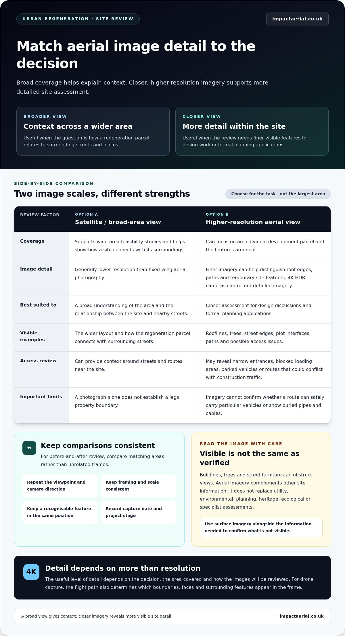
Image clarity and resolution
Resolution determines which details remain legible when a team enlarges an image. A broad view may show the overall layout, while finer imagery can help distinguish roof edges, paths and temporary site features. The useful level of detail for a planning discussion depends on the decisions being made, the area covered and how the images will be reviewed.
For consistent before-and-after images, repeat the viewpoint, camera direction, framing and scale for each capture. Keep recognisable features, such as a junction or roofline, in the same position, then compare matching areas rather than unrelated frames. Record the capture date and project stage with each image set so teams can interpret changes in context.
Satellite imagery generally has lower resolution than fixed-wing aerial photography. Satellite views can support wide-area feasibility studies, while higher-resolution aerial photographs can capture details needed for design work and formal planning applications. A broad image, for example, may show how a regeneration parcel connects to surrounding streets, while a closer view can reveal how a proposed building relates to an existing access route.
Clarity also depends on capture conditions. Shadows from tall buildings can obscure a courtyard or narrow lane, while trees may hide ground-level features. Capturing the area from another angle can make it easier to assess. Consistent framing matters too: a steeply angled image may show façades clearly, but it distorts the apparent shape of roads and plots compared with a more vertical view.
Choose the image format to suit its intended use. A planning team reviewing a site layout needs legible boundaries and surrounding context; a public presentation may prioritise a clear, accessible overview. Keep original image files alongside edited copies, and label viewpoints consistently. This preserves detail for later review and helps colleagues distinguish an adjusted presentation image from the original capture.
Before commissioning a capture, define the features that must be visible, such as roof edges, pavement markings or vegetation. A clear brief aligns image clarity and coverage with the review task, rather than relying on a visually striking image that lacks useful detail.
Scale and geographic coverage
UK urban development corporations typically cover 100-650 hectares, manage multi-billion-pound investment programmes, and remain in place for 20-40 years. A single view cannot show every decision-making scale equally well. Separate imagery can relate an individual plot to nearby streets, then place that plot within the wider regeneration area.
Set coverage around the question being examined. A development team assessing one parcel needs clear local detail, while a council tracking regional land-use change needs a wider view. The Battersea Power Station regeneration project covers 42 acres, illustrating how even a defined urban scheme can contain varied buildings, routes and public spaces.
Drone photography suits local inspection, as adjustable viewpoints can focus on a particular site or feature. Satellite imagery is collected from hundreds of miles above Earth and can capture large geographic areas in one image. It supports regional land-use monitoring and environmental tracking, while generally offering lower resolution than fixed-wing aerial photography.
For UK site-specific planning applications, high-detail aerial photography is typically the preferred choice. Crewed fixed-wing aircraft can capture higher-resolution imagery than satellites, while drone photography can provide close views of an individual development parcel. The right platform depends on the area, level of detail and purpose required.
For regeneration programmes covering a wider district, satellite imagery can help track seasonal vegetation patterns or construction progress across a large county over several years. Aerial photographs can add local context when teams need to assess a particular parcel. Keeping the geographic scope consistent across review periods makes comparisons more useful.
Define the site boundary and intended decisions before arranging a capture. For a focused view of a development parcel, arrange aerial photography that matches the project’s coverage needs.
Satellite imagery can capture large geographic areas in a single image and provide frequent, automated updates, making it suited to regional land-use monitoring and large-scale environmental tracking. Aerial photography provides local detail for evaluating individual development parcels.
The Clichy-Batignolles eco-district in Paris redevelops 54 hectares of former railyard, while Shanghai planned to demolish and rebuild 365 hectares of dilapidated housing stock during its 1990s and 2000s redevelopment. The Historic England Archive preserves over 6 million aerial photographs, supporting access to a substantial record for local comparison.
Impact Aerial: Aerial Filming and Photography
Impact Aerial provides Aerial Filming and Photography for teams needing clear visual records of regeneration sites. It can be useful when planners, developers or project teams need aerial views to assess site context, communicate proposals or document changes over time. Its commercial-grade drones use high-resolution cameras, supporting detailed imagery for project review.
For a regeneration scheme, define the areas and features that matter, such as site edges, access routes or surrounding buildings, so the imagery matches the intended review. Aerial photography complements other project information, including specialist surveys when ground conditions or buried services need assessment.
Contact Impact Aerial to discuss aerial filming and photography for your regeneration project.
Turn your site review into a practical next step
Give the imagery a defined role in the project after capture. A shared reference set helps planning, design and delivery teams discuss the same locations, record decisions and identify where additional technical information is needed. Organising image files by project area and review stage also makes later comparisons easier to interpret.
The aerial work a regeneration team needs depends on the site and its purpose. Aerial photography for urban regeneration schemes can support visual reviews, while specialist requirements may call for a different service. Impact Aerial provides Aerial Filming and Photography, PV Solar Farm Thermal Surveys and Drone Commercial Property Surveys.
If you’re preparing a site review, outline the area, intended use and key features you need to assess. Contact Impact Aerial to discuss your project and consider how aerial imagery could support your next planning or design decision.
Frequently Asked Questions
How is aerial photography used in urban regeneration schemes?
Aerial photography for urban regeneration schemes gives project teams a shared visual reference for design discussions, stakeholder briefings and phased works. For example, a council can use an annotated overview to show how a proposed public space relates to surrounding buildings and routes, helping residents and delivery teams discuss the same plan. The imagery supports communication and review, while technical surveys establish measurements or conditions that photographs alone cannot verify.
 2 Norton Drive, Wythall, Birmingham, B47 6HH Company registration number: 11138586. VAT Number: 366 9068 55


