
What if every project conversation started with the same current view of the site? Improving site communication with drone data begins by addressing a familiar challenge: teams often rely on updates gathered at different times and from different ground-level perspectives. This can leave people unsure about what has changed or with different interpretations of progress.
Aerial imagery gives project teams a wider visual reference, but images alone don’t guarantee clearer communication. Capture them consistently, share them with useful context and discuss them alongside on-site knowledge and professional judgement. Drone data can support those conversations; it doesn’t replace inspections or project-team decisions.
This guide explains how to build a repeatable approach to capturing relevant site information and using it as shared evidence. You’ll learn what to consider when planning regular updates, how to make aerial imagery easier for stakeholders to interpret, and how a clear capture process can support better-informed progress discussions. Impact Aerial’s construction site monitoring provides professional aerial data collection to help teams establish a common visual reference.
Key Takeaways
- Improving site communication with drone data starts with a clear question: decide what the team needs to understand before planning an aerial capture.
- Make imagery useful by organising the evidence, adding context and sharing it with the people involved in the decision.
- Separate what an image directly shows from measurements, interpretations and decisions, which may require further professional review.
- Use a repeatable routine for capture, file naming, review and distribution, with clear responsibility for each step.
- Impact Aerial supports construction site monitoring and drone data collection across the UK, using CAA GVC certified pilots and commercial-grade equipment, with £5m commercial liability insurance.
How Drone Data Can Improve Construction Site Communication
Site communication with drone data means sharing relevant aerial evidence, such as photographs, video or survey information, with enough context for project stakeholders to discuss site conditions and progress. The evidence gives people a common visual reference. The project team interprets what it shows and decides what action, if any, is needed.
This is different from the radio data link between an aircraft and its operator. That link carries control signals and may transmit information during flight. Project-team communication happens after or around capture, when relevant evidence is organised and shared with people such as site managers, contractors and clients. A drone can communicate with its operator without any useful site update reaching the wider team.
What counts as drone data on a construction site?
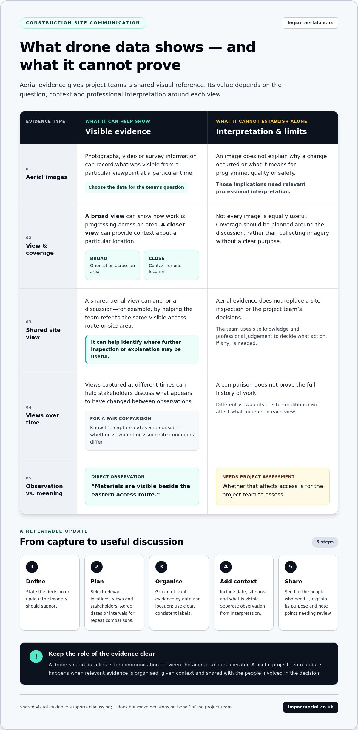
Drone data may include aerial photographs, video or survey information. Choose the type according to the question the team needs to discuss. A broad view can show how work is progressing across an area, while a closer image can provide context about a particular location. Plan the capture around that purpose rather than treating every image as equally useful.
Imagery provides evidence of what was visible from a particular viewpoint at a particular time. On its own, it doesn’t explain why a change occurred or what it means for programme, quality or safety. Those are matters for the relevant professionals to interpret using project knowledge and other information. For background on the aircraft itself, see the overview of the unmanned aerial vehicle.
Why a shared aerial view can clarify site updates
Ground-level updates can be accurate yet incomplete: different people may see different parts of a site or describe the same area in different ways. A shared aerial view can anchor the discussion. For example, when reviewing access routes, the team can refer to the same visible location instead of relying only on verbal descriptions. This makes it easier to identify the area under discussion and where further inspection or explanation may be useful.
Dates add important context. Comparing views captured at different times can help stakeholders discuss what appears to have changed between observations. For a fair comparison, the team should know when each view was captured and consider whether the viewpoint or visible site conditions differ. Aerial evidence supports the conversation, but it doesn’t prove the full history of work or replace a site inspection.
Improving site communication with drone data therefore depends on more than collecting images. Teams need relevant views, clear dates and a shared understanding of what the evidence can show. Professional commercial drone survey methods can help inform how aerial information is captured for a project’s needs.
From Drone Capture to a Clear, Useful Site Update
A useful site update starts before the drone is airborne. First agree what the team needs to understand, then capture and present only the evidence that helps answer that question. This five-step workflow gives project teams a practical, platform-neutral way to move from aerial capture to a clear discussion.
- 1. Define the question. State the decision or update the imagery should support. For example, is the team reviewing progress in a particular work area, or looking at access routes? A focused question prevents a broad collection of images from becoming an update with no clear purpose.
- 2. Plan the capture. Identify the site locations and views relevant to the question, along with the stakeholders who need to see them. A site-wide view may provide orientation, while a closer view can show a specific location. If repeat comparisons matter, agree dates or intervals and use consistent viewpoints where practical.
- 3. Organise the evidence. Group the relevant images or video by date and location, and give each item a clear, consistent label. Keep selected views together so recipients can find the evidence for the area being discussed without sorting through unrelated material.
- 4. Add context. Include the capture date, site area and a concise description of what is visible. Separate direct observation from interpretation or proposed action. For instance, “materials are visible beside the eastern access route” describes an observation; whether that affects access is for the project team to assess.
- 5. Share for a defined purpose. Send the update to the people who need it and explain what question it supports. Invite review of the evidence and note any points that need an on-site check or further professional interpretation. A clear update informs decisions; it doesn’t make them on behalf of the team.
Plan around the decision, not the flight
Before capture, name the area and audience. A project manager reviewing general progress may need a broader view than a subcontractor discussing one work zone. Matching coverage to the decision keeps the update focused and helps avoid collecting imagery stakeholders can’t readily use. Consistent locations and viewpoints also make later comparisons easier to discuss, while dates help everyone understand when each view was recorded.
Make each update easy to interpret
Use the same basic structure each time: question, date, location, selected evidence, observations and points for discussion. Keep descriptions factual and concise. If a view is obscured or doesn’t show the detail needed, say so rather than implying it answers the question. This simple discipline makes communication clearer without requiring a particular software platform. Professional aerial capture is one part of the process; the team remains responsible for interpretation and decisions. A guide to professional drone services in the UK explains how aerial services can support different project needs.
Improving site communication with drone data is easier when capture and updates follow a repeatable routine. For projects that need professional aerial capture, Impact Aerial’s construction site monitoring can provide relevant site evidence for the team’s update process.
What Drone Data Shows – and What It Cannot Prove
Aerial imagery can show visible site conditions from a particular viewpoint at a particular time. It can help teams identify where to look and what to discuss, but it doesn’t automatically establish measurements, causes, quality or completion status. Keep three layers distinct: what is directly visible, what the team thinks it may mean, and what additional evidence is needed to verify that interpretation. This distinction is central to improving site communication with drone data.
Use a simple evidence check before drawing conclusions:
| Visible evidence | Possible interpretation | What may be needed to validate it |
|---|---|---|
| A material stockpile appears smaller in a later view. | Materials may have been moved or used. | Delivery and usage records, site-team confirmation or other relevant project records. |
| A work area looks clear in an aerial image. | Work in that area may have progressed. | On-site review and project records to establish whether the required work is complete. |
| A surface or structure looks different between views. | A change may have occurred. | Consistent comparison views and, where the decision requires it, appropriate measurements or inspection. |
Aerial imagery versus verified project information
A photograph may show equipment, materials or visible activity, but not whether work meets its specification. A moved pile doesn’t prove that materials were installed, and a clear-looking work area doesn’t establish completion. The image can prompt a useful question; records, measurements or an on-site check may be needed to answer it. Don’t present illustrative imagery as a certified survey result or as proof of a conclusion it cannot support.
The required verification depends on the decision. If a team is discussing whether a location needs follow-up, a visual reference may help identify the area. If it must confirm dimensions, workmanship or completion against project requirements, the relevant professional evidence is needed. Drone imagery can support that review, not replace it.
Why consistent capture and context matter
Comparisons can mislead when images show different angles, distances or site conditions. A new viewpoint may reveal an area hidden in an earlier image, making change appear greater or smaller than it is. Buildings, equipment or stored materials can also obscure details. Weather and lighting may affect visibility, while conditions that affect safe flight planning can limit what can be captured. Capture plans must account for safety and compliance.
For a fair comparison, record the capture date and location, use consistent viewpoints where practical, and include relevant project references so readers know which area is shown. If the views differ, say so rather than treating them as a direct comparison. Clear context helps stakeholders assess the evidence proportionately and identify where further validation is required.
Build a Repeatable Drone-Data Communication Routine
A routine makes aerial updates easier to request, review and use. It also prevents the process from depending on one person’s memory or preferred file-naming habits. Agree who owns each stage, what an update needs to contain and how often the team needs a fresh view. The right cadence depends on active work and upcoming decisions, not a universal schedule.
Use this checklist to keep recurring updates organised:
- Request: The project lead or nominated site representative identifies the question, locations and stakeholders for the update.
- Capture: The capture lead plans relevant views around the agreed site area and purpose, using consistent viewpoints where comparison matters.
- Name: The person organising the evidence applies a shared convention, such as project, location and capture date, so files are easy to identify later.
- Review: A designated reviewer checks that the views are relevant, labels are clear and any limitations or missing context are stated.
- Share: The update owner circulates the selected evidence to the appropriate stakeholders and records follow-up questions or actions through the project’s usual process.
Set a consistent cadence and clear ownership
Assign a named role for requesting capture, reviewing the evidence and circulating the update. One person may hold more than one role, but each responsibility should be clear. Set the frequency around the work being monitored and the decisions stakeholders need to make. A stable date and location convention helps teams compare updates and retrieve earlier views without relying on individual memory.
For example, if a project team needs to review a changing work area before a coordination discussion, plan the update to support that discussion. If site activity or decision needs change, adjust the cadence rather than collecting views simply because a fixed interval has passed.
Make updates useful to different project stakeholders
Lead with the question, then show the relevant view. A site manager may need a concise overview, while a team discussing a specific location may need a closer view and a clear label. Keep captions factual, separate observation from interpretation and identify uncertainty, such as an area obscured in the image. This helps recipients understand both what the evidence shows and what still needs review.
Professional capture also depends on appropriate operational planning. Impact Aerial uses CAA GVC certified pilots for its UK drone services; the UK drone licensing and CAA rules guide provides further context on qualified, compliant operations. Improving site communication with drone data means making the evidence, ownership and purpose clear at every stage.
To establish a reliable capture routine for your project, explore Impact Aerial’s construction site monitoring and survey support.
How Impact Aerial Supports Clearer Site Communication
Clear site communication depends on relevant aerial evidence being captured for a defined project purpose. Impact Aerial supports construction teams across the UK with commercial drone data collection surveys and construction site monitoring. Its role is to provide professional aerial capture that can contribute to the team’s agreed update process, while project stakeholders retain responsibility for interpreting evidence, carrying out inspections and making decisions.
That distinction matters. A drone survey is not a substitute for the project team’s knowledge or management systems. It can provide a useful visual reference for a question such as, “What has changed in this work area since the previous capture?” The team can then consider the imagery alongside its own records and professional judgement.
What professional aerial data collection contributes
Planned capture focuses aerial imagery on the site areas and views relevant to a communication need. For a recurring update, the project team can identify locations where a consistent perspective would help stakeholders discuss visible changes. The capture approach can be shaped around the project brief, with safe and compliant flight planning guiding what can be recorded. The value lies in relevant evidence, not simply in collecting more imagery.
Impact Aerial uses commercial-grade drones and CAA GVC certified pilots. The business also holds £5m commercial liability insurance. These operational credentials support a professional approach to aerial data collection, while the imagery remains one source of information for the project team to review.
Prepare a useful brief for a site project
A focused brief gives the capture process a clear purpose. Include the site or project area, the communication objective, who needs to use the update and when the information is relevant. Identify specific locations and progress questions, then note whether repeat views will support comparison. For example, a team might want a view of a defined access area to discuss visible changes before a coordination meeting.
Keep the brief practical. State what the team needs to see, rather than prescribing a conclusion the imagery should prove. If an area or question changes, update the brief so capture remains aligned with current project needs. This makes it easier to select relevant evidence and helps stakeholders understand why it was collected.
For construction teams, improving site communication with drone data starts with aligning the project question and the aerial capture. Impact Aerial supports the capture stage through its survey and site-monitoring work across the UK; the project team can then bring that evidence into its established review and decision-making processes.
To discuss a drone data project, share your site monitoring or survey requirements with Impact Aerial. A clear outline of the site, intended audience and key questions is a practical starting point for planning relevant aerial data collection.
Make Your Next Site Update More Useful
Choose one upcoming project decision and use it to shape the next aerial update. A focused starting point helps the team test whether the selected views answer the right question, who needs the information and what further context would make it easier to act on. After the update, gather feedback from the people who use it and refine the approach for the next capture.
That deliberate step can help turn improving site communication with drone data into a practical part of project coordination, rather than a separate task that produces imagery without a clear audience. Keep the project team’s judgement at the centre, and let aerial evidence support a more informed discussion.
Impact Aerial provides UK construction site monitoring and commercial drone data collection to support relevant site capture. Discuss your construction site data requirements with Impact Aerial and take the next step towards clearer project updates.
A well-defined first brief gives your team a practical place to start.
Frequently Asked Questions
Can drone data replace a construction site visit?
No. Drone data can help people review visible site conditions remotely, but it can’t provide everything a site visit offers. A visit may be needed to inspect details hidden from above, speak with site personnel or assess conditions that imagery cannot capture. For example, an aerial view might help identify an area for follow-up, while an in-person inspection checks a specific concern. Use aerial evidence to inform site visits, not as a substitute for them.
How often should a construction site be captured by drone?
There’s no single schedule that suits every project. Set capture frequency around how quickly relevant site conditions change and when stakeholders need evidence for decisions. A team might plan captures around key project milestones or coordination reviews, then adjust if activity shifts. For a stable area, frequent repeat views may add little value. The aim is to collect information at a useful point in the project, not simply to follow a fixed calendar.
Can drone imagery be used in a BIM workflow?
Yes, drone imagery or survey information may support a BIM workflow if the data is suitable for the intended use and compatible with the project’s requirements. A photograph doesn’t automatically become a model or verified comparison. Before relying on aerial information in BIM, the project team should establish the required format, coordinate reference and level of detail, then validate how the information will be reviewed. Data capture and BIM integration are separate activities.
What can affect the quality of drone data on a construction site?
Visibility, weather, lighting, camera angle and obstructions can all affect what captured information shows. Buildings, cranes or stored materials may conceal areas, while a different viewpoint can make comparison difficult. Movement during capture can also reduce image clarity. If a view doesn’t show the required detail, it shouldn’t be treated as evidence of that detail. A useful project brief helps the capture plan account for the locations and conditions that matter.
Is drone data suitable for sharing with clients and subcontractors?
Yes, provided the selected information is relevant to its audience and shared through the project’s agreed channels. A client may need a concise overview, while a subcontractor may need a view tied to a specific work area. Before distribution, consider project confidentiality, access permissions and whether the imagery could reveal sensitive site details. Clear labels and appropriate context help recipients understand the material without treating it as a final technical determination.
Does drone data provide real-time construction site updates?
Usually, no. A live connection between a drone and its operator supports flight operations, but it doesn’t mean stakeholders receive a reviewed, decision-ready site update in real time. Captured information generally needs to be selected, organised and shared through the project’s process. If a decision depends on current conditions, the team should consider whether aerial capture, direct site communication or an inspection is the appropriate source for that need.
Who can interpret drone data for construction decisions?
The appropriate project professionals interpret aerial information in line with the decision being made. A site manager may use imagery to discuss visible progress, while a surveyor or engineer may need to assess measurement or technical questions using suitable evidence. Stakeholders should distinguish what an image visibly shows from conclusions that require specialist knowledge or other records. Drone data can inform their assessment, but it doesn’t make project decisions on their behalf.
 2 Norton Drive, Wythall, Birmingham, B47 6HH Company registration number: 11138586. VAT Number: 366 9068 55


