
After a storm, a loss adjuster may need to assess roof damage that is unsafe or impractical to reach. Aerial inspection for loss adjusters can provide views of exposed areas, but useful evidence depends on planning the flight around the specific claim question. Images alone cannot establish every cause or reveal concealed damage.
Drone imagery can help document roofs, chimneys and other hard-to-access features. The key is to understand what it can show, where its limits lie, and when a closer or different assessment is needed.
This guide covers when aerial imagery may support a property claim, what evidence and records to request, and how to assess a provider’s credentials, safety arrangements, insurance and data handling. It also explains how to define the inspection scope, capture requirements and deliverables so the material can be reviewed in your claims workflow. Agreeing these points in advance helps ensure the inspection addresses a practical question rather than simply collecting images.
Key Takeaways
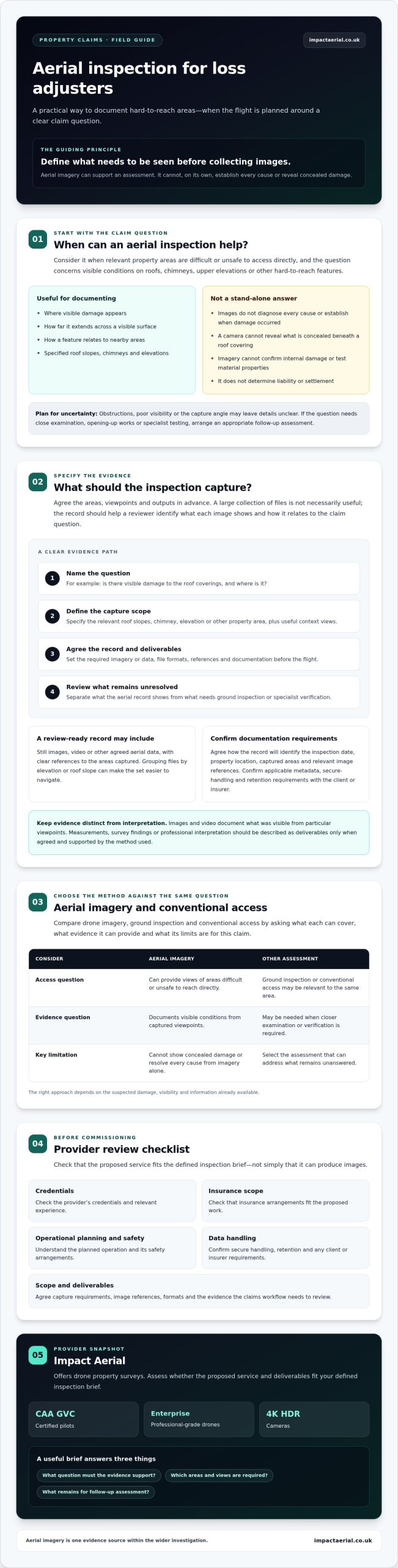
- Consider aerial inspection when a claim involves areas that are difficult or unsafe to access, while recognising when another assessment may be needed.
- Agree the imagery or data required before the flight, including views that help identify where and what each image shows.
- Compare drone imagery with conventional access and ground inspection against the same claim question, including the coverage and limits of each method.
- Before commissioning, check the provider’s credentials, insurance scope, operational planning, relevant experience and proposed deliverables.
- Impact Aerial offers drone property surveys, with CAA GVC certified pilots, professional-grade enterprise drones and 4K HDR cameras. Assess whether its proposed service fits your defined inspection brief.
When can aerial inspection help a loss adjuster assess property damage?
Aerial inspection for loss adjusters uses imagery or other data captured remotely from the air to examine relevant parts of a property. It can provide views of roofs, chimneys and upper elevations when direct access is difficult or may introduce avoidable safety risks.
This method is most useful when the claim question concerns visible conditions: where damage appears, how far it extends across a visible surface, or how it relates to nearby features. Aerial views can add context, but they support the assessment rather than determine liability or a settlement. For background on ways imagery and data can be collected from above, see this overview of aerial survey methods.
Here is an example of drone imagery being used in a property-claim inspection context:
Which property claim questions can drone imagery help investigate?
Begin with the question the evidence needs to help answer. Is there visible damage to the roof coverings? Where is it, and what surrounding features help put it in context? A planned set of views may document a chimney, roof slope or building elevation, giving the adjuster material to review without implying that imagery can diagnose the cause.
Suitability depends on the suspected damage, visibility and information already available. A clear view may help document a surface’s visible condition, but it may not distinguish between damage mechanisms or establish when damage occurred. Specify the area and question the capture should address instead of requesting general footage alone.
When is an aerial inspection not enough?
A camera cannot show what is concealed beneath a roof covering, confirm internal damage or test the properties of a material. Obstructions, poor visibility and the angle of capture can also leave details unclear. If the claim depends on close examination, opening-up works or specialist testing, arrange an appropriate follow-up assessment.
Use aerial imagery as one evidence source within the wider investigation, not as a substitute for the adjuster’s professional judgement. A ground-level inspection or input from a relevant specialist may be needed to resolve questions that images cannot answer. This helps distinguish what the aerial record shows from what still needs verification.
What evidence can an aerial property inspection capture and deliver?
An aerial inspection can provide still images, video and other agreed aerial data, depending on the brief, property and conditions for safe capture. For a roof claim, the requested views might cover specified roof slopes, a chimney or adjoining elevations. A large collection of files is not necessarily useful evidence. The output should help the adjuster identify each area shown and relate visible features to the claim question.
Keep captured imagery distinct from conclusions drawn from it. Photographs and video document what was visible from particular viewpoints. Describe measurements, survey findings or professional interpretation as deliverables only when they have been specifically agreed and are supported by the method used. A consistent, navigable record can support the claims review, alongside the professional context and resources of the Chartered Institute of Loss Adjusters.
A well-scoped aerial inspection delivers a clearly labelled record of agreed property areas and viewpoints, in formats suited to the claim question.
How should inspection images be documented for a claim file?
Agree how the image set will identify the inspection date, property location, areas captured and relevant image references. A simple naming system, such as grouping files by elevation or roof slope, makes review easier and reduces uncertainty about what each view depicts. Include context to orient the reviewer, not just close views that may be difficult to place.
Requirements for metadata, secure handling and retention can vary by client or insurer. Confirm the applicable requirements before commissioning and check that the supplied record meets them. Do not assume that a file’s appearance alone confirms how or when it was captured.
What deliverables should adjusters agree before the flight?
Specify the inspection areas and viewpoints, the claim questions the capture should inform, and the required file and reporting formats. Clarify whether the brief calls for stills, video or other aerial data, and whether annotations, editing or post-production are included or separately agreed. These details help the operator plan the capture and the adjuster review the evidence against the original request.
For broader background on planning aerial data collection, see this drone survey guide. Before commissioning a claims-related inspection, you can also discuss property survey requirements and confirm the proposed scope and deliverables.
Drone inspection versus conventional access: how should adjusters compare them?
Compare each method against the same claim question rather than assuming one approach is always better. A drone can capture remote views of exterior surfaces; access equipment can bring an inspector closer to selected areas; and a ground inspection can document visible conditions from accessible locations. The appropriate method depends on the property, suspected damage and evidence needed for the next decision.
Use this comparison as a starting point, then check that the proposed method can capture the evidence required:
| Consideration | Aerial imagery | Access equipment | Ground inspection |
|---|---|---|---|
| Access | Views selected areas remotely, subject to flight feasibility. | Provides closer access to chosen locations, subject to safe setup and site conditions. | Examines areas visible from the ground or accessible within the property. |
| Visible coverage | Can show roof slopes, chimneys and elevations from planned viewpoints. | Can focus on a specific area at close range, with coverage shaped by access arrangements. | Can cover accessible surfaces and wider property context, but may not show upper or obscured areas clearly. |
| Operational planning | Requires consideration of weather, obstructions and applicable flight constraints. | Requires suitable equipment, access arrangements and site planning. | Requires safe access to the areas being inspected and coordination as needed. |
| Evidence format | Still images, video or other agreed aerial data. | Close visual observations, photographs or other agreed records. | Observations and records gathered during the ground-level inspection. |
| Limitations | May not reveal concealed conditions or provide the close view needed. | May not be practical or appropriate for every location or inspection scope. | Visibility can be limited by height, distance or obstruction. |
Which inspection method fits the property and damage scenario?
Consider roof height, site access, suspected damage and the inspection purpose together. Aerial capture may help document visible conditions across a roof, while close physical examination may be more suitable if the decision depends on detail that a remote view cannot resolve. Weather, obstructions and flight constraints can also affect whether aerial capture is feasible. A combined aerial and ground-level assessment may address different evidence needs.
How can adjusters judge whether captured evidence is usable?
Check that each relevant area is identifiable, the visible condition is clear and the image provides enough context to locate it on the property. Look for blur, obstruction, missing viewpoints or gaps in coverage before relying on the set. If the evidence does not answer the claim question, request clarification or arrange follow-up. For a separate overview of credentials and rules, see the UK drone licensing guide.
Aerial inspection for loss adjusters is useful when its coverage and image quality are adequate for the decision at hand. Treat the images as evidence to assess, not as a guarantee that every relevant condition has been established.
What should loss adjusters check before commissioning an aerial inspection?
A clear brief helps the operator plan a suitable capture and gives you a standard for reviewing the evidence. Before booking an aerial inspection, work through the claim question, site requirements, provider checks and delivery arrangements. Ask the provider to flag limitations, access dependencies and contingency arrangements in advance, including what may happen if weather or other conditions prevent the planned capture.
What should the inspection brief specify?
Set out the question the inspection should support, the property areas involved, known damage and the viewpoints that may help document it. Include practical arrangements such as site access, a named contact and any timing constraints. Then agree the deliverables, how files should be labelled and how they will be returned for the claim file.
- Claim scope: identify the relevant building areas and the visible conditions to document.
- Site coordination: confirm access arrangements, contacts and restrictions that could affect the inspection.
- Evidence handover: agree file types, labelling, reporting format and any metadata or retention requirements.
Ask how the provider will report gaps or views that could not be captured. A documented limitation is more useful than an unclear assumption that every requested area was visible.
Which safety, privacy and compliance checks matter in the UK?
Ask how the operator will assess the site, people nearby, obstructions and flight conditions before confirming the plan. Verify the pilot’s credentials and the applicable Civil Aviation Authority requirements and permissions for the specific operation. A general statement of compliance is not enough on its own; the proposed flight and site circumstances matter.
Check that the provider’s insurance wording and scope are appropriate for the assignment, and ask about relevant experience with similar property work. Clarify how identifiable imagery will be handled, stored, shared and retained, and confirm responsibilities under applicable UK GDPR requirements with the provider. These checks help protect the operation and the resulting claim records.
Before commissioning, verify the pilot, assignment-specific permissions, insurance scope, site plan, relevant experience and agreed evidence handover.
Review the final delivery to confirm that files are complete, labelled as agreed and cover the requested areas. If something is missing or unclear, raise it before treating the evidence set as complete. For a defined property survey brief, discuss your inspection requirements with Impact Aerial and confirm the scope and deliverables before commissioning.
How can Impact Aerial support a loss-adjuster inspection brief?
Impact Aerial provides drone property surveys and data collection that may suit some claims-related inspection requirements. Its stated capabilities include CAA GVC certified pilots, commercial-grade DJI Enterprise drones and 4K HDR cameras. These details can inform your provider assessment, but the key question is whether the proposed capture can address your specific brief.
Impact Aerial states that it holds £5m commercial liability insurance. Before instructing work, confirm that the policy wording and scope are appropriate for the property, planned operation and assignment. Establish the provider’s relevant experience, availability, operational plan and deliverables for the specific brief rather than assuming these from general service information.
What can adjusters discuss with a prospective provider?
Share the property type, inspection purpose, suspected damage and outputs needed to support the claim. For example, specify which areas require coverage and whether you need labelled still images, video or another agreed form of aerial data. This gives the provider a basis for discussing whether the requested capture is feasible at that site.
Before commissioning, clarify practical details:
- Site arrangements: access, site contacts and any relevant timing constraints.
- Operational planning: how the proposed flight will be assessed, including applicable requirements and permissions.
- Evidence delivery: agreed file formats, labelling, reporting and handover arrangements.
- Limitations: areas that may be obstructed or inaccessible, and contingency arrangements if conditions affect the planned capture.
Confirm these points before giving an instruction, and ask how any incomplete or unclear capture will be reported. A defined scope keeps the evidence aligned with the claim question and makes the handover easier to assess.
How to take the next step with a UK drone survey provider
Aerial inspection for loss adjusters should be considered against the actual evidence need, not treated as an automatic step for every claim. A brief-led discussion can help establish whether aerial imagery is suitable, what it may show and whether another assessment may also be required. For wider context on choosing a provider, read this professional drone services guide.
If a drone property survey appears appropriate, share the claim requirements and ask Impact Aerial to confirm the proposed scope, feasibility and deliverables before commissioning. Discuss an aerial inspection brief with Impact Aerial.
Make the next inspection decision with confidence
Aerial inspection for loss adjusters is most valuable when it is planned around a clear claim question and delivers evidence that can be reviewed in context. Use imagery to support, not replace, professional judgement, and arrange a different or complementary inspection when the evidence needs closer examination.
Before commissioning, agree the areas to capture, required outputs and how records should be labelled and delivered. Check the provider’s credentials, operational plan, relevant experience and assignment-specific insurance scope. These steps set clear expectations before work begins.
Impact Aerial provides drone property surveys and data collection, with CAA GVC certified pilots and commercial-grade DJI Enterprise drones equipped with 4K HDR cameras, according to the company’s information. It also states that it holds £5m commercial liability insurance. Confirm that the policy wording, proposed operation and deliverables are appropriate for your assignment.
Have a property or claim brief to assess? Discuss an aerial inspection brief with Impact Aerial and explore whether the proposed capture fits your evidence requirements. A clear scope is a practical first step towards a well-documented inspection.
Frequently Asked Questions
Can drone imagery be used as evidence in a property claim?
Drone imagery may support a property claim assessment, but whether it is accepted depends on the claim, the insurer’s requirements and the relevant decision-maker. Images can document visible conditions, such as damage seen on a roof, but they do not automatically prove what caused it or establish liability. Before commissioning an inspection, confirm what evidence is required, how it should be recorded and whether the intended recipient has specific format or documentation expectations.
When is an aerial inspection useful for a loss adjuster?
An aerial inspection can help document visible areas that are difficult or unsafe to reach directly, including roofs, chimneys and upper elevations. Its usefulness depends on the claim question, site conditions and level of image detail needed. Aerial inspection for loss adjusters can provide visual context, but it may not resolve questions requiring close examination. A ground-level assessment or relevant specialist may still be needed to investigate details the imagery cannot show.
Can a drone inspection identify hidden roof damage?
No. A drone inspection cannot see through roof coverings or confirm concealed defects from imagery alone. It may record visible features, such as displaced tiles or apparent surface damage, but those images do not establish what lies beneath or inside the structure. Depending on the suspected damage and claim requirements, a closer physical inspection, appropriate testing or assessment by a relevant specialist may be needed to investigate further and inform the adjuster’s judgement.
What should a loss adjuster ask an aerial inspection provider?
Ask about relevant property-inspection experience, pilot credentials, assignment-specific insurance scope, site planning and proposed deliverables. Share the claim question, known damage and required viewpoints so the provider can discuss feasibility and limitations. Confirm how images will be labelled, delivered and handled, including data requirements relevant to the claim file. Before instructing the work, check the operational plan and verify which requirements or permissions apply to the particular site and flight.
Does a drone inspection replace a roof survey or physical inspection?
No. Aerial capture gathers visual information and is not automatically a replacement for a roof survey or physical inspection. The appropriate method depends on access, suspected damage, the evidence needed and the professional judgement of those assessing the claim. Aerial views may document hard-to-reach surfaces, while close examination may be necessary to investigate details or concealed conditions. In some cases, combining aerial imagery with ground-level or specialist assessment may be appropriate.
How do UK drone rules affect a property inspection?
Drone operators must assess the proposed flight and comply with applicable current Civil Aviation Authority requirements. The relevant arrangements depend on the operation and site, so a general assurance does not confirm that a particular flight is suitable. Ask the provider about pilot credentials, any permissions needed, people and risks at the site, and planned operating conditions. Verify these details for the property and circumstances before commissioning the inspection.
What information should be included in an aerial inspection report?
Agree on a record that identifies the inspection date, property areas captured, relevant viewpoints and labelled images, along with any stated limitations. Clear labels help reviewers understand which part of the building each image shows and whether requested areas were covered. Report, image and metadata requirements can differ between clients, insurers and assignments. Set the required format and retention expectations with the relevant party, then confirm them with the provider before the flight.
 2 Norton Drive, Wythall, Birmingham, B47 6HH Company registration number: 11138586. VAT Number: 366 9068 55


