
Why are you still budgeting thousands for scaffolding and cherry pickers when the most critical structural data is often just a flight away? You’ve likely felt the frustration of marking a roof area as “inaccessible” or worrying about the liability risks of sending personnel to height. It’s a logistical burden that often leads to incomplete building surveys and inconsistent reporting.
This guide demonstrates how a professional chartered surveyor drone survey bridges the gap between traditional expertise and high-precision aerial technology. By integrating RICS-compliant data collection into your workflow, you can secure high-resolution imagery for defect identification while significantly reducing inspection timelines.
We’ll examine the technical requirements for 2026, including the transition to RPC-L1 Part A qualifications and the necessity of robust commercial insurance. From navigating CAA regulations to identifying guttering and chimney stack issues, you’ll learn how a meticulous, data-centric approach to aerial inspections provides the reassurance and reliability your clients expect.
Key Takeaways
- Understand why traditional access methods like scaffolding are being replaced by non-invasive drone technology for faster, safer initial building inspections.
- Discover the technical power of 4K HDR imagery and orthomosaic mapping in identifying hairline defects that manual ground-based inspections often miss.
- Learn how a professional chartered surveyor drone survey ensures RICS compliance and protects your professional indemnity insurance through CAA-certified operations.
- Explore advanced applications such as thermal imaging for moisture detection and specialized, non-contact surveys for heritage and listed building conservation.
- Gain insights into the DJI Enterprise workflow used by West Midlands specialists to deliver high-precision aerial data for both local and national property portfolios.
The Evolution of Building Inspections: Why Chartered Surveyors Use Drones
The methodology behind property assessment is undergoing a fundamental shift. The Evolution of Building Inspections has moved from physical climbing to digital capture, utilizing Unmanned Aerial Vehicles (UAVs) to gather high-resolution structural data. A professional chartered surveyor drone survey offers a non-invasive alternative to traditional visual inspections. It allows for a detailed examination of a building’s envelope without disturbing the fabric of the property or requiring direct physical contact with fragile surfaces.
To see how these aerial techniques are applied in a real-world setting, watch this demonstration of a professional roof inspection:
Traditional Access vs. UAV Efficiency
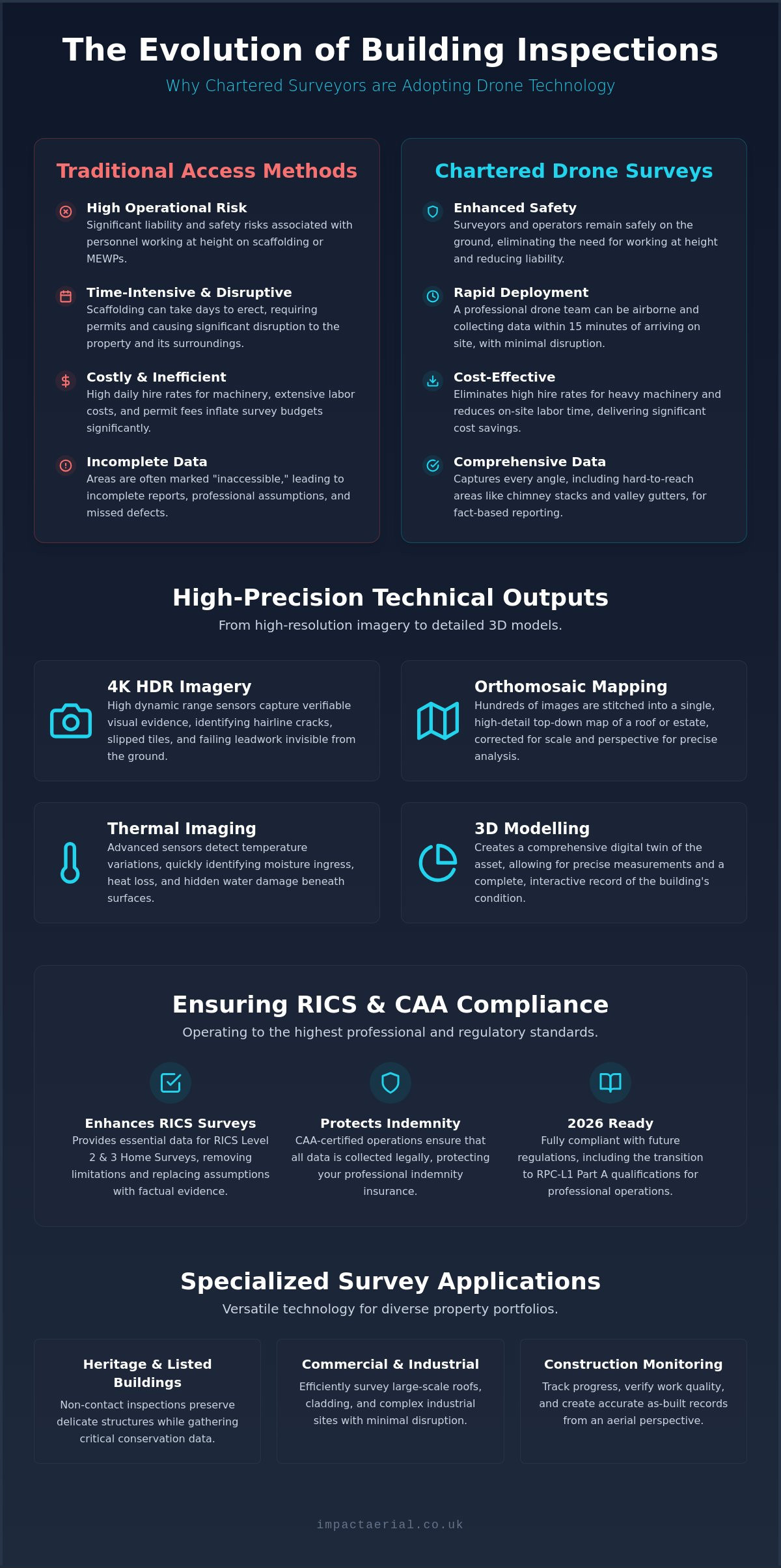
Traditional access methods like scaffolding or Mobile Elevating Work Platforms (MEWPs) often involve significant logistical hurdles. Erecting scaffolding can take days of labor and requires extensive pavement licenses and health and safety permits. In contrast, a professional drone team can deploy within 15 minutes of arriving on site. Choosing a chartered surveyor drone survey over traditional methods doesn’t just save time; it provides a level of perspective that ground-based tools simply cannot match. For multi-storey commercial properties, the cost-benefit analysis is clear. Drones eliminate the high daily hire rates of heavy machinery and the associated site disruption. Most importantly, it keeps the surveyor safely on the ground. By removing the need for personnel to work at height, firms drastically reduce their liability and operational risk while maintaining a meticulous standard of inspection.
Enhancing RICS Survey Standards
Aerial data is now a vital component for RICS Level 2 and Level 3 Home Surveys. Standard ground-based inspections frequently encounter “limitations” when dealing with high-level chimney stacks, hidden valley gutters, or parapet walls. These areas are often where the most severe structural defects reside, such as failing leadwork or slipped tiles. By using DJI Enterprise hardware, we capture 4K HDR imagery that supports RICS professional guidance notes on building surveys. This high-tier output allows for the identification of hairline cracks and moisture ingress points that are invisible from the street level. By providing verifiable visual evidence of high-level building components, drone data removes the need for professional assumptions in survey reports, ensuring a higher standard of factual accuracy.
Technical Data Outputs: High-Resolution Imagery to 3D Modelling
The value of a chartered surveyor drone survey is found in the density and precision of the data captured. Modern DJI Enterprise hardware utilizes 4K HDR sensors to produce imagery with exceptional dynamic range. This technical capability is essential for identifying hairline structural cracks or subtle tile slippage that a standard camera might miss. While cinematic drones focus on aesthetics, professional surveying equipment prioritizes visual evidence and geometric accuracy. Every flight is a methodical data collection exercise designed to provide a comprehensive digital record of the asset.
Beyond individual photographs, we utilize orthomosaic mapping to create high-detail, top-down “maps” of large estates or complex roof structures. These maps are generated by stitching hundreds of overlapping images together, corrected for perspective and scale. This provides a panoramic overview that remains perfectly sharp even when zoomed in to a specific chimney stack or valley gutter. When conducting these operations, we ensure full compliance by Navigating UK Drone Regulations in 2026, ensuring your data is collected legally and under the correct operational authorizations. We deliver this data in several professional formats to suit your workflow:
- High-density point clouds for BIM and Revit integration
- Georeferenced orthomosaic maps for site planning
- Interactive 360-degree virtual tours for remote site visits
- 4K HDR video and high-resolution still imagery for defect reporting
Visual Inspection for Roofs and Gutters
Hidden roof valleys and internal gutters are notorious for harboring blockages and vegetation growth. A professional drone survey allows for the documentation of these areas without the risk of ladder access or the cost of scaffolding. We provide crystal-clear imagery that serves as a definitive visual record, making it easier for surveyors to justify recommended repair works to stakeholders. For those managing multiple assets, our drone commercial property surveys offer a streamlined way to assess portfolio health with technical precision.
Digital Twins and Photogrammetry for Surveyors
Photogrammetry transforms aerial imagery into measurable 3D digital twins. By processing overlapping photos into a point cloud, surveyors can take precise measurements of roof pitches, surface areas, and structural dimensions remotely. This data integrates into CAD environments, supporting Scan-to-BIM workflows for architectural conservation and complex refurbishments. These time-stamped digital models provide a baseline for long-term property management. They allow you to compare structural conditions over several years to monitor movement or degradation with absolute confidence.
Safety and Compliance: Navigating UK Drone Regulations in 2026
Compliance in the UK drone industry is a matter of strict legality rather than mere preference. When a firm commissions a chartered surveyor drone survey, they aren’t just hiring a camera; they’re entering a highly regulated aviation environment. Hiring an amateur or unlicensed pilot doesn’t just risk a fine from the Civil Aviation Authority; it fundamentally compromises the surveyor’s professional standing. Most professional indemnity insurance policies specifically require that any sub-contracted aerial work is performed by an operator holding valid CAA Operational Authorization. If an incident occurs during an unauthorized flight, the surveyor’s insurance may be voided, leaving the firm exposed to significant financial and legal liability.
Professional operators mitigate these risks through a structured approach to flight safety. This begins long before the drone leaves the ground. A meticulous pre-flight site assessment is conducted for every project, identifying potential hazards such as overhead power lines, nearby airports, or public thoroughfares. This process ensures that the data collection is not only high-quality but also conducted within the strict safety parameters set by national aviation standards. By adhering to these protocols, we provide a level of reliability that protects both the integrity of the survey and the reputation of the surveying firm.
Hiring a CAA GVC Certified Pilot
The General Visual Line of Sight Certificate (GVC) remains a critical qualification for commercial drone operations in complex or urban environments. While regulatory standards evolved in 2026, the GVC continues to be a benchmark for pilots managing risks in congested areas. For a deeper look at these requirements, you can read our UK Drone License guide for the latest regulatory context. Certified pilots are trained to manage flight permissions in restricted zones and coordinate with Air Traffic Control when necessary. They don’t just operate the hardware; they produce detailed Risk Assessments and Method Statements (RAMS) that are essential for site health and safety files.
Insurance and Liability for Property Surveys
Commercial drone insurance is a legal mandate under UK regulation. Standard public liability policies often exclude aviation-related incidents, which is why specialized UAV cover is non-negotiable for professional work. We maintain £5m in commercial liability insurance, providing a robust layer of protection for the surveyor, the client, and the public. This high level of coverage is essential when operating near high-value commercial developments or sensitive heritage sites. Working with a fully vetted and insured UAV operator provides the essential reassurance that all site risks are professionally managed and mitigated.
Specialized Survey Applications: From Heritage to Construction
A professional chartered surveyor drone survey extends far beyond simple roof photography. It serves as a sophisticated data collection tool for specialized sectors where traditional access is either impossible or prohibitively expensive. By deploying DJI Enterprise hardware equipped with various sensors, we provide surveyors with the technical evidence needed for complex valuations and structural assessments. Whether you are managing a high-tier commercial asset or a sensitive historic site, aerial data delivers a level of detail that ground-based methods can’t replicate. It’s a partnership that combines the surveyor’s expertise with our meticulous approach to flight operations and data precision.
Conservation and Heritage Drone Surveys
Heritage assets demand a sensitive approach. Traditional scaffolding can cause more damage than the inspection itself; this makes UAV technology the preferred choice for architectural conservation. We capture high-level masonry detail on churches, stately homes, and listed sites without any physical contact with the structure. This non-invasive method is essential for documenting the condition of delicate stonework or lead flashings on buildings where preservation is the priority. For firms across the West Midlands managing historic portfolios, our drone commercial property surveys offer a non-invasive way to secure high-resolution conservation data and digital archives.
Thermal Surveys for Building Performance
Thermal imaging adds a layer of diagnostic power to a building inspection. By using radiometric sensors, we identify “cold bridges”, insulation gaps, and hidden moisture ingress that are invisible to the naked eye. This is particularly valuable for commercial flat roofs where temperature differentials can pinpoint the exact location of a leak before it causes structural failure. Our specialized PV solar farm thermal surveys also help estates monitor energy efficiency and asset health at scale. These insights support “Green” surveys and help landlords make data-driven decisions regarding energy efficiency improvements and long-term maintenance strategies.
Construction and Insurance Valuations
In the construction sector, drones provide a steady stream of progress data. We assist with construction site monitoring by tracking build phases and providing volumetric analysis of stockpiles with high accuracy. This visual record is equally vital for Insurance Reinstatement Cost Assessments. Having a detailed, time-stamped record of a building’s current condition ensures that insurance valuations are based on factual data rather than estimates. This meticulous documentation provides the reassurance and reliability that both the insurer and the property owner require during the valuation process.
Partnering with Impact Aerial: Professional Drone Surveys in Birmingham and Beyond
Choosing a partner for a chartered surveyor drone survey requires a balance of technical expertise and regional knowledge. At Impact Aerial, we position ourselves as technical consultants rather than just hardware operators. Our team understands that the data we capture must be robust enough to stand up to professional scrutiny and RICS reporting standards. We combine the high-tier visual quality of professional aerial filming with the meticulous precision required for structural defect identification. It’s this commitment to quality that provides our clients with the reassurance and reliability they need when managing high-value assets.
Being based in Birmingham gives us a distinct advantage for firms operating within the West Midlands. We understand the local landscape, from the industrial heritage sites of the Black Country to the modern commercial developments in Birmingham city centre. This regional proximity allows us to respond quickly to survey requests while maintaining a deep understanding of local airspace restrictions and logistical challenges. While we provide national coverage, our roots in the West Midlands ensure that local firms receive a personalized, expert service that a distant agency can’t match.
Our Drone Surveying Process
Our DJI Enterprise workflow is designed to be methodical and transparent. We follow a structured three-phase process to ensure every flight is safe, legal, and data-rich:
- Phase 1: Desktop Feasibility and Compliance: Before arriving on site, we conduct a comprehensive feasibility study. This includes checking CAA airspace for restricted zones, identifying local hazards, and ensuring all operational authorizations are in place for the specific location.
- Phase 2: Technical On-Site Capture: Using commercial-grade DJI hardware, our GVC certified pilots execute a precision flight plan. We prioritize the capture of 4K HDR imagery and technical data points that allow for the identification of hairline cracks and moisture ingress.
- Phase 3: Secure Data Delivery: Once the flight is complete, we process the data for secure delivery. We use cloud-based platforms that allow surveyors to access high-resolution files and 3D models easily, facilitating seamless integration into professional RICS reports.
Booking Your Survey in the West Midlands
We provide comprehensive regional coverage across Birmingham, Coventry, and the wider UK. Whether you require a one-off inspection for a residential roof or a recurring monitoring program for a large-scale construction site, we offer bespoke quotes tailored to your specific requirements. For a deeper understanding of how these technologies fit into the broader industry, you can read A Complete Guide to Professional Drone Services. To ensure a successful flight, we simply need a clear brief regarding the target areas and any specific defects you wish to investigate. Our team handles the rest, from risk assessments to final data delivery, ensuring your chartered surveyor drone survey is conducted to the highest professional standards.
Elevating Your Professional Building Surveys
Integrating high-precision aerial data is no longer a luxury for modern firms; it’s a technical necessity for comprehensive reporting. We’ve explored how a chartered surveyor drone survey removes the limitations of traditional access, providing RICS-compliant imagery and measurable 3D models. By prioritizing safety and regulatory adherence, you ensure that every inspection is backed by factual evidence rather than professional assumptions. The transition to advanced sensors like thermal imaging and 4K HDR hardware allows for a deeper understanding of building performance, from heritage conservation to large-scale construction monitoring.
Impact Aerial provides the technical expertise and operational reassurance required for high-tier property assessments. Our CAA GVC Certified Pilots utilize expert DJI Enterprise hardware and maintain £5m commercial liability insurance to protect your firm and your clients. We’re ready to help you capture the critical data that ground-based methods miss. Contact Impact Aerial for a Professional Drone Survey Quote and secure the high-resolution insights your next project demands. We look forward to supporting your professional surveying standards with precision and reliability.
Frequently Asked Questions
Do I need to be present during the drone survey?
You don’t need to be physically present during the flight operations. As long as we have confirmed access and completed the necessary site safety checks, our pilots can operate independently. Some surveyors prefer to attend to view the live 4K feed on our ground station, which allows them to direct the camera toward specific defects or areas of concern in real-time.
Can drones fly in rain or high winds during a building inspection?
Professional drone operations are weather-dependent to maintain both safety and data integrity. We don’t operate in active precipitation or winds that exceed the safety thresholds of our DJI Enterprise hardware, which is typically around 22 mph. If the weather is unfavorable, we’ll reschedule the flight to ensure your imagery is clear and free from motion blur or lens distortion.
Is a drone survey legal in a busy city centre like Birmingham?
Yes, conducting a chartered surveyor drone survey in urban environments like Birmingham is perfectly legal when performed by a CAA GVC certified operator. We handle the complex task of securing flight permissions and coordinating with Air Traffic Control or local authorities. Our meticulous pre-flight planning ensures that all flights in congested areas adhere to strict national safety standards.
How accurate is drone data for measured building surveys?
Drone data is exceptionally accurate, often providing centimetre-level precision when used for photogrammetry. By capturing overlapping high-resolution images, we can generate 3D point clouds and digital twins that allow for remote measurements of roof pitches and surface areas. This technical output provides a reliable baseline for structural monitoring and architectural planning without the need for manual measurement at height.
What is the typical turnaround time for drone survey data?
Most standard aerial imagery and video data are delivered within 24 to 48 hours after the on-site capture is complete. For more complex deliverables, such as 3D models or thermal mapping, the processing time may extend to 72 hours. We use secure cloud-based platforms for data delivery, ensuring you can integrate the high-resolution files into your professional reports immediately.
Does a drone survey replace a traditional RICS building survey?
A drone survey is designed to enhance, not replace, the expertise of a Chartered Surveyor. It serves as a non-invasive data collection tool that captures visual evidence in areas that are otherwise inaccessible. The surveyor remains the lead professional who interprets this high-resolution data to identify structural defects and provide an authoritative assessment of the property’s condition.
What insurance does a drone pilot need for a property survey?
A professional drone pilot must hold specialist commercial UAV insurance that is compliant with EC 785/2004 regulations. Standard public liability insurance typically excludes aviation risks, making it insufficient for commercial work. We maintain £5m in commercial liability cover, which provides the essential reassurance and protection required when operating near high-value commercial or residential assets.
How much does a chartered surveyor drone survey cost?
The cost of a chartered surveyor drone survey is determined by the specific requirements of the project, including site complexity and the type of data sensors required. Factors such as the location’s airspace restrictions and the need for advanced 3D modelling will influence the final pricing. We provide bespoke, project-specific quotes to ensure the service is scaled to the technical needs of your building inspection.
 2 Norton Drive, Wythall, Birmingham, B47 6HH Company registration number: 11138586. VAT Number: 366 9068 55


