
A drone survey is most useful when it helps answer a project question. Effective drone construction monitoring starts with the decision the team needs to make: comparing progress with an earlier capture, reviewing a work area or coordinating site information with a BIM model.
Aerial data can make site updates easier to compare, but photographs, mapped outputs and topographical surveys serve different purposes. More imagery won’t make progress clearer if the capture plan, deliverables and accuracy requirements aren’t agreed in advance.
This practical guide explains how repeat aerial captures can support progress reviews and project decisions, and how to choose outputs that fit your reporting and coordination needs. It also covers the planning required for a useful, compliant survey, from defining the area and capture schedule to aligning data with construction workflows.
Impact Aerial provides construction site monitoring and commercial drone data collection across the UK. Its CAA GVC certified pilots operate professional-grade commercial drones equipped with 4K HDR cameras, and the company maintains £5 million commercial liability insurance. The sections ahead explain what to plan before a survey and how to make the resulting information useful to your project team.
Key Takeaways
- Start with the project decision you need to make, then select imagery, mapped data or survey measurements to suit it.
- Build a repeatable capture plan with a clear baseline, consistent viewpoints, timing and site boundaries to make progress comparisons more useful.
- Choose drone construction monitoring outputs that match the needs of site teams, survey users or BIM coordination, while recognising the limitations of each data type.
- Set out site conditions, work areas and intended deliverables before planning a survey. Flight requirements depend on the location and current UK rules.
- A clear project brief connects capture planning with data handover, helping the results fit existing construction workflows.
What drone construction monitoring can show across a live UK building site
A single photograph shows what an area looks like today. A planned series of captures can show how visible conditions change over time, helping teams review progress, access and the relationship between work areas. That is the practical purpose of drone construction monitoring: creating a consistent aerial record to support project decisions.
Choose the output to suit the question. Photographs show site context; mapped imagery provides a wider spatial overview; survey measurements support decisions that depend on dimensions or levels. These outputs are related, but they aren’t interchangeable.
For a visual example of aerial data being used to review construction progress, watch:
In brief: visual monitoring documents visible site change; measured survey data provides spatial information for tasks requiring defined measurements. A drone image alone doesn’t establish dimensional accuracy or prove that construction complies with a design or specification. Those conclusions depend on appropriate data, measurement methods and professional checks.
What information can repeated drone captures provide?
Dated images from comparable viewpoints help teams review visible changes between visits. They might show a new access route, a work area opening or closing, materials being moved, or earthworks taking shape. Consistent viewpoints, site boundaries and capture timing make comparisons easier to interpret.
When captured and processed appropriately, an orthomosaic can provide a mapped overview of the site. It can help teams orient themselves and discuss the position of visible features, but it shouldn’t be treated as a measured survey unless the work was specified and completed to support that use.
When does monitoring help a construction team?
A planned capture gives progress meetings and stakeholder updates a shared visual reference. Teams can review visible changes, discuss emerging issues and identify areas that may need closer attention. The record supports these conversations, but it doesn’t replace site inspections or other required checks.
For projects using digital models, drone imagery or processed data may contribute to coordination workflows, depending on the required outputs. BIM is a framework for managing information associated with a built asset, as described in this overview of Building Information Modeling. For more on choosing aerial data methods and outputs, see our complete drone survey guide.
How a drone construction monitoring programme turns captures into progress records
A useful monitoring programme is designed around decisions, not just flight dates. The team should know what it wants to review, what record will make that review possible and whether the task needs visual evidence or measured data. A consistent process then turns each capture into a record that can be compared and shared.
Plan the baseline, capture area and repeat schedule
Before the first flight, define the question and the area it concerns. A progress meeting may need an overview of the whole site, while an earthworks review may focus on a specific work zone. Record a baseline, then agree the site boundary, viewpoints and deliverables with the people who will use the information.
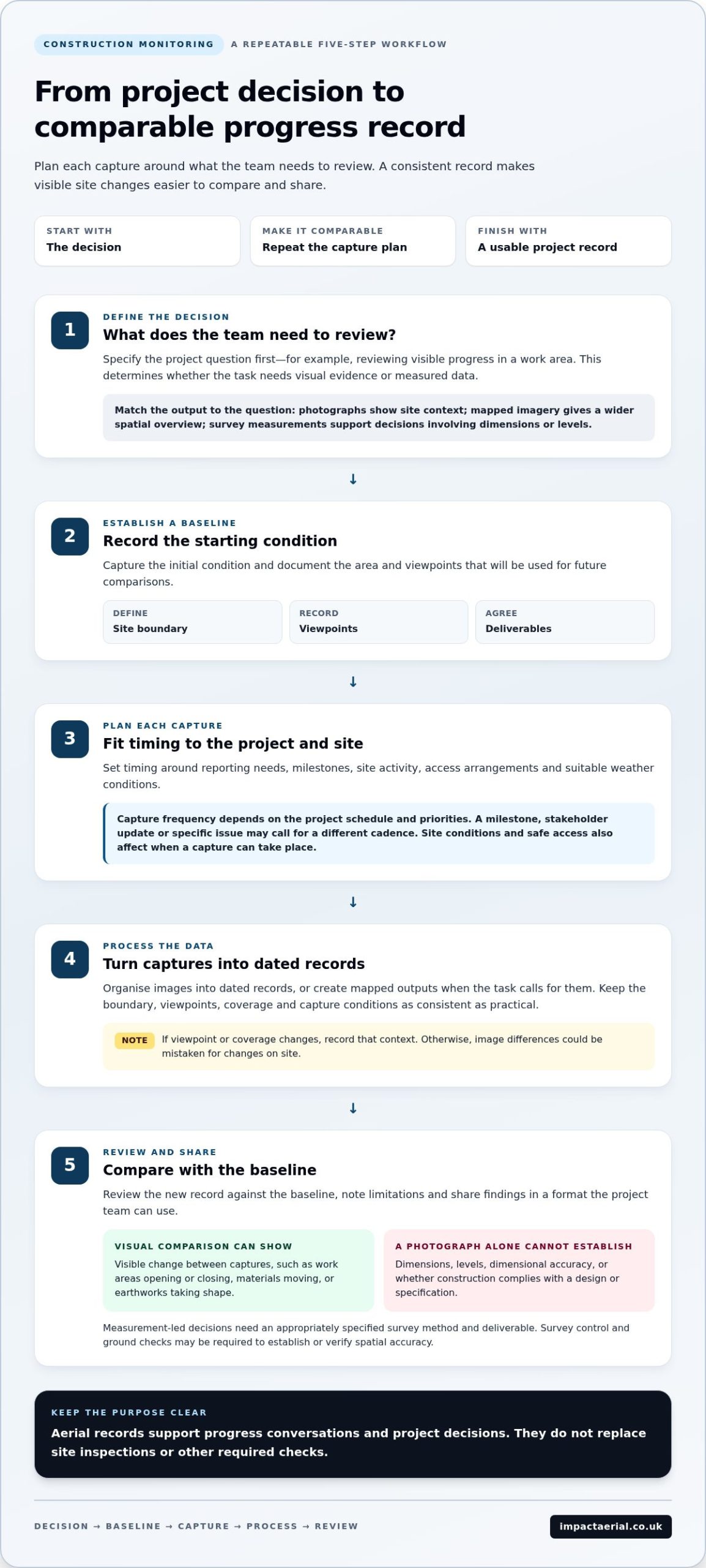
Use this five-step workflow:
- 1. Define the decision. Specify what the team needs to review, such as visible progress in a work area.
- 2. Establish a baseline. Capture the initial condition and document the area and viewpoints for future comparison.
- 3. Plan each capture. Set timing around reporting needs, milestones, site activity, access arrangements and suitable weather conditions.
- 4. Process the data. Organise images into dated records or create mapped outputs when the task calls for them.
- 5. Review changes. Compare the new record with the baseline, note limitations and share findings in a format the project team can use.
Set capture frequency according to the project’s schedule and priorities. A key milestone, regular stakeholder update or specific issue may call for a different cadence. Site conditions and safe access also affect when a capture can take place, so a fixed calendar alone may not suit every phase of work.
Process and review the data for project decisions
Repeatability makes comparisons clearer. Keeping the boundary, viewpoints, coverage and capture conditions as consistent as practical helps teams focus on site changes rather than differences between images. If the viewpoint or coverage changes, record that context; otherwise, an image difference could be mistaken for a change on site.
Visual comparison can show visible change, but it doesn’t establish dimensions or levels. For measurement-led decisions, specify the survey method and deliverable accordingly. Survey control and ground checks may be required to establish or verify spatial accuracy. The appropriate approach depends on the project, and accuracy claims must relate to the capture method, control used and agreed specification. A photograph by itself is not a measured result.
Impact Aerial’s construction monitoring is planned around the project brief and intended handover. Explore construction monitoring with Impact Aerial as part of a considered capture-to-review workflow.
Drone monitoring, BIM and topographical surveys: choose the right data
The right output depends on the decision. A visual record can help a team discuss visible progress, while a topographical survey provides measured spatial information. BIM is a way to manage and coordinate project information, not a drone capture method in itself. Drone construction monitoring can support these workflows, but specify the required data and checks for the intended use.
| Output | Typical question answered | Measurement needs | Intended user and limitations |
|---|---|---|---|
| Visual progress record | What has visibly changed since the last capture? | Usually visual comparison rather than dimensional measurement. | Useful for project teams and stakeholders. Viewpoint and coverage differences can affect comparisons. |
| Mapped imagery | Where are visible features in relation to the site? | Capture and processing must suit the required mapped use. | Can help teams review the wider site context. It isn’t automatically a verified survey. |
| Topographical survey | What are the measured ground features, levels or terrain conditions? | Requires a defined survey method, control and any necessary ground verification. | Supports design and engineering decisions. Accuracy depends on the project specification and survey approach. |
| BIM-linked data | How does captured site information relate to project models or information? | May require suitable georeferencing, validation and agreed data formats. | Useful for coordination between project and design teams. A visual capture alone may not be model-ready. |
Drone imagery and a topographical survey aren’t interchangeable: imagery shows visible conditions, while a survey provides measurements produced to a defined specification.
When is a topographical survey more suitable than visual monitoring?
Choose a measured survey when a decision depends on terrain, ground levels, site features or spatial relationships needed for design coordination. Survey control helps position measurements within an agreed reference framework, while ground checks can verify relevant features or observations. The survey specification should set out the required outputs and accuracy; don’t infer either from image resolution alone.
How can drone data support BIM coordination?
Dated aerial context can help teams discuss site status alongside project information, including which areas have visibly changed. That doesn’t make every image or mapped output suitable for direct model use. Georeferencing, validation, file format and model requirements need to match the coordination workflow. For broader context, consider how commercial drone data collection can support site information and project coordination.
Plan a safe, useful drone construction monitoring survey in the UK
A useful survey needs two plans: what information the project needs and how the capture can be carried out safely. Site layout, active work and nearby airspace can all affect the operation. Permissions and safety controls depend on the location and current UK requirements, so generic rules alone aren’t enough to establish that a flight is suitable.
What should the project team prepare before a capture?
Share the information that will help the survey team plan the flight and deliver relevant outputs. Coordinate with the principal contractor and site team before the planned capture, including access, induction, communication and any site-specific exclusion arrangements.
A monitoring brief should cover:
- Site information: the site boundary, plans and any nearby airspace or location constraints.
- Capture priorities: work areas, key views, project milestones and the questions each capture should help answer.
- People and access: planned access routes, active work, site contacts, induction arrangements and agreed controls around people.
- Timing and conditions: suitable capture windows in relation to site activity, weather and changing conditions.
- Intended handover: whether the team needs visual records, mapped imagery or another specified output, and how it will be used in reporting.
This information aligns the capture with site operations rather than treating a flight as a standalone activity. If work moves, access changes or conditions differ on the day, the plan may need to be adapted.
How do professional credentials and safety planning build confidence?
Impact Aerial operates with CAA GVC certified pilots and £5 million commercial liability insurance. These credentials provide relevant reassurance, while project-specific planning remains essential. The capture plan considers site conditions and operational requirements, with coordination arranged around the agreed work area, access and intended deliverables.
CAA requirements and operational guidance can change, and applicable requirements depend on the operation and location. For more detail, read this guide to UK drone licences and CAA rules. A project brief should never assume that one general checklist covers every site.
Before arranging drone construction monitoring, assemble the site plan, priority areas, milestone dates, access and communication arrangements, known constraints and required data outputs. Plan a construction monitoring survey with Impact Aerial around your project brief and site requirements.
Construction monitoring with Impact Aerial: from project brief to usable data
Good construction monitoring begins with a clear brief. The project team’s objectives guide the capture plan, the areas to document and the information to hand over. This keeps the work focused on how the data will be used, whether for progress discussions, stakeholder updates or wider site coordination.
What happens from the first project discussion to delivery?
Impact Aerial starts by understanding the site, project stage and team priorities. Early discussion helps define the purpose of the monitoring, the areas of interest and the intended reporting use. Capture planning can then be aligned with site arrangements and the agreed brief.
The handover is considered at the outset, not left until after capture. The team discusses suitable project outputs and how they’ll fit into existing information processes. Agree data formats and specifications as part of the project brief. Clear communication throughout helps the project team understand what is planned and what the delivered information is intended to support.
When should a construction team request a monitoring discussion?
Engage early if you need a baseline before major work begins. It’s also useful to plan around reporting milestones, recurring progress reviews or changes in site conditions that could affect what needs to be documented. Early planning gives the team time to align capture priorities with site activity and define a practical handover.
Impact Aerial provides construction monitoring and commercial drone data collection across the UK. The team operates commercial-grade DJI Enterprise drones with 4K HDR cameras, with CAA GVC certified pilots and £5 million commercial liability insurance. These capabilities support a managed workflow, while the capture plan and data outputs are tailored to the project brief. Camera specifications alone don’t establish survey accuracy; any measurement-led requirement needs an appropriate, agreed method and specification.
To discuss your site, milestones and intended outputs, discuss construction drone monitoring with Impact Aerial. A focused conversation about project requirements is a practical first step towards planning a useful capture programme and suitable data handover.
Make your next site update more useful
Effective drone construction monitoring starts with the project decision, then matches the capture plan and data output to what the team needs to review. Repeatable captures make visible progress easier to compare, while mapped outputs, topographical surveys and BIM-linked data each serve different purposes. Agreeing the intended use, accuracy requirements and handover early helps keep the information practical.
Impact Aerial provides construction monitoring and drone data collection services across the UK, using commercial-grade DJI Enterprise drones with 4K HDR cameras. CAA GVC certified pilots and £5 million commercial liability insurance support a safety-conscious approach to planning site work.
Whether you need a baseline before work begins or a plan for milestone updates, start with your site priorities and intended outputs. Discuss your construction monitoring requirements with Impact Aerial and take a clear next step towards more useful project information.
Frequently Asked Questions
What is drone construction monitoring?
Drone construction monitoring is the planned use of aerial captures to document and review visible site conditions over time. Teams can compare dated photographs or mapped imagery to discuss progress, access and changes across work areas. These visual records don’t automatically provide verified measurements or prove construction compliance. If a decision depends on dimensions, levels or design tolerances, the project needs an appropriate survey method and defined data specification.
How do drones monitor construction site progress?
A drone captures images of agreed site areas from planned viewpoints, creating records that can be reviewed against earlier captures. Depending on the brief, imagery may be organised as dated photographs or processed into a mapped overview. Teams can use the records in progress meetings to discuss visible changes or areas needing attention. Consistent coverage and viewpoints support comparison, while site inspections and other checks remain important.
Can drone data be used in BIM?
Yes, drone data can support BIM coordination when the capture and deliverables suit the project’s information requirements. Dated imagery can give teams visual context alongside a model, while model-ready data may require suitable georeferencing, validation and agreed file formats. A photograph or orthomosaic isn’t automatically ready to load into a BIM workflow. Define the intended use, required outputs and acceptance criteria with the project team before capture.
What is the difference between drone monitoring and a topographical survey?
Drone monitoring usually records visible site conditions to support progress review, while a topographical survey provides measured information about features such as terrain and levels. The outputs serve different decisions. A visual record may help a team see changes, but it doesn’t establish dimensions or survey accuracy by itself. Measurement work should follow a defined specification and suitable control or ground verification where required by the project.
How often should a construction site be monitored by drone?
Set the capture frequency around project milestones, reporting cycles and the decisions teams need to make. A baseline before major work, followed by captures around key stages, may suit one project; another may need a different cadence. Site activity, access, weather and operational conditions also affect scheduling. Agree the interval with the team using the records, then review it if project priorities or site conditions change.
Are drone construction surveys allowed in the UK?
Drone surveys can be conducted in the UK when the operation meets applicable Civil Aviation Authority requirements and any location-specific permissions and safety controls. Requirements depend on factors such as the site, airspace and operation, so a general rule isn’t sufficient for every flight. Impact Aerial operates with CAA GVC certified pilots and £5 million commercial liability insurance, alongside planning appropriate to the project and location.
What information should I provide for a construction drone monitoring brief?
Provide a site plan and boundary, priority work areas, milestones, intended reporting use and the outputs the team needs. Include access and induction arrangements, site contacts, active work areas, known constraints and relevant nearby airspace information. If measurements or BIM coordination are required, describe the intended use and project specifications. This helps shape capture planning and a handover that fits the project workflow.
 2 Norton Drive, Wythall, Birmingham, B47 6HH Company registration number: 11138586. VAT Number: 366 9068 55


