
A drone image doesn’t strengthen a construction bid simply because it looks impressive. Using drone imagery to win construction bids works best when each visual supports a specific claim, such as your understanding of the site, access or project constraints.
Written proposals can be hard to make tangible. Images added without a clear purpose can leave evaluators unsure what they demonstrate. Choose aerial views against the tender criteria, then explain how each one supports your proposed approach.
This guide covers how to brief a focused capture, choose visuals that support evaluation criteria and present them with clear captions. It also explains how to plan for permissions, operational safety and review time around a tender deadline. In the UK, professional planning matters as much as image quality. Impact Aerial’s CAA GVC-certified pilots use commercial-grade aircraft with 4K HDR cameras, with project support from initial consultation through post-production.
Key Takeaways
- Using drone imagery to win construction bids means matching every visual to a tender claim, not simply adding attractive aerial shots.
- Choose stills, edited video or mapping outputs according to the evidence needed. Distinguish visual context from measured survey data.
- Plan around tender requirements, capture, site coordination and final approval so the imagery is relevant and ready to include.
- Address safety, permissions and evidence limitations. Aerial visuals can clarify site conditions but don’t guarantee compliance or replace technical data.
- Impact Aerial provides professional capture and post-production, with CAA GVC-certified pilots and £5m commercial liability insurance.
Why using drone imagery to win construction bids starts with the evaluation criteria
An impressive aerial view can attract attention, but it strengthens a construction bid only when it helps prove a specific point. Start with the tender’s evaluation criteria: identify what the client needs to understand, then select imagery that makes your response clearer and more specific to the project.
A well-framed view can show how a site relates to its surroundings, where access routes sit, or how neighbouring constraints may affect the proposed sequence. Use the image to help evaluators picture your methodology and understand the reasoning behind it, rather than as decoration. Images support your case, but they can’t guarantee an award or replace mandatory written, technical or other requested evidence.
For context on the medium itself, see this overview of Aerial photography. The bid-writing principle is straightforward: connect each image to a clear response point.
To see how drone mapping can contribute to project decisions, watch this video:
Which construction bid claims can aerial visuals help explain?
A site overview can orient evaluators to boundaries, surroundings and access routes. For example, pair an annotated overview with a logistics explanation that identifies the proposed delivery entrance, internal vehicle route and work zones. In the caption, state what the view shows and why it matters to the plan. Progress or context imagery can also help, provided it supports a specific methodology or delivery claim.
How to keep bid imagery relevant rather than decorative
Map each proposed visual to an evaluation criterion, response section or project risk. Give every image a concise caption that identifies the relevant feature and its significance, so evaluators don’t have to infer the point. Remove images that don’t support a stated requirement or project-specific argument. Avoid claims about improved safety, faster delivery or cost savings unless the bid provides evidence for them.
Before submission, apply this relevance test: What should the evaluator understand from this image, and where does the bid explain why it matters? If there’s no direct answer, the visual may be unnecessary. A focused selection helps keep the proposal clear and makes its evidence easier to assess.
Choose the right drone imagery for each construction bid requirement
The right format depends on what the tender asks you to demonstrate and how the evaluator will use the evidence. When using drone imagery to win construction bids, choose visuals to clarify a claim, not simply because a format looks impressive. A photograph can explain site context, but it doesn’t provide survey-grade measurements by itself.
Photography, video, mapping or survey data: what supports the bid?
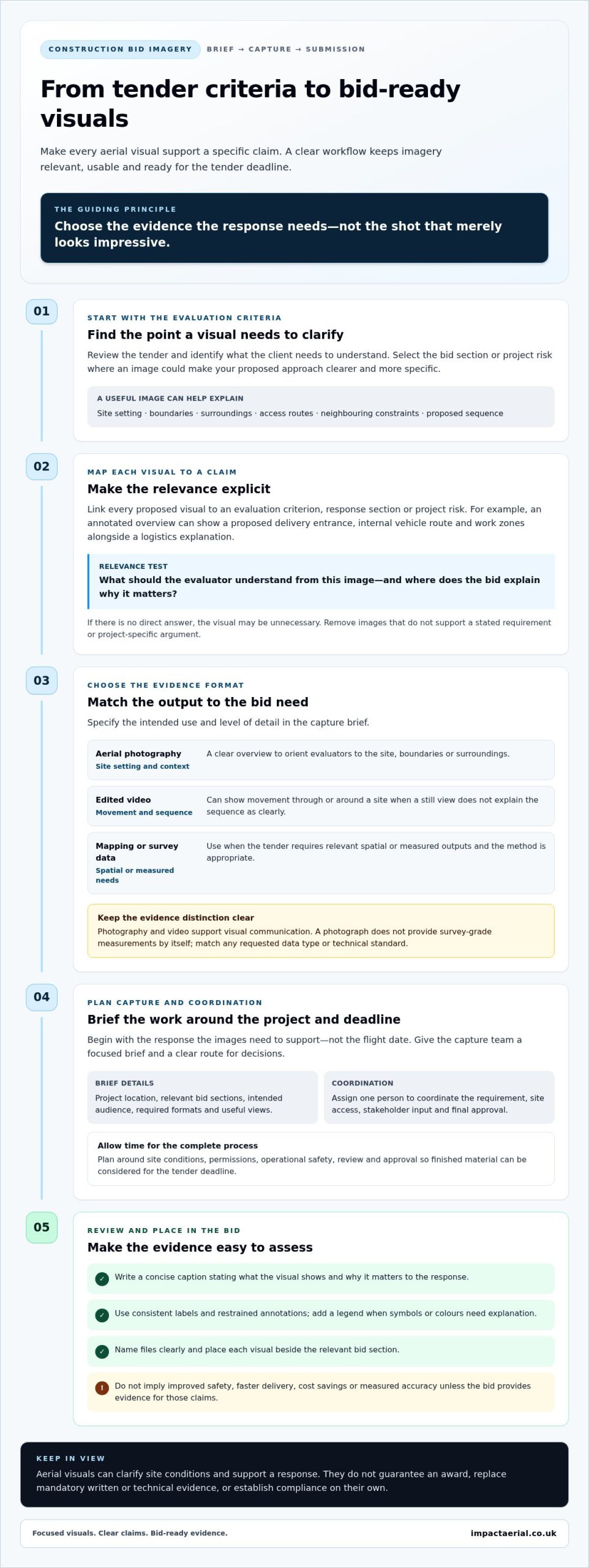
Use this comparison to match the output to the evidence required. In your capture brief, specify the intended use and the level of detail needed.
| Bid need | Useful format | What it can help show |
|---|---|---|
| Site setting, boundaries or surroundings | Aerial photography | A clear overview that helps orient evaluators and provide visual context. |
| Access, movement or a proposed sequence | Edited video | Movement through or around the site, where a still view may not explain the sequence as clearly. |
| Spatial relationships or measured information | Mapping or survey data | Relevant spatial or measured outputs, when the tender requires them and the method is appropriate. |
Photography and video support visual communication; mapping and survey outputs serve different technical purposes. Don’t present a photograph as measured evidence or imply that every aerial capture provides the accuracy a survey requirement may demand. If the tender specifies a data type or technical standard, make sure the proposed output matches it.
Presentation affects how easily evaluators can use the evidence. Write a concise caption that states what the visual shows and how it supports the response. Use consistent labels and restrained annotations, adding a legend when symbols or colours need explanation. Name files clearly and place visuals beside the relevant bid section. For more image-planning ideas, read this drone photography guide.
Impact Aerial’s aerial filming, photography and post-production services can support a project-specific imagery brief. A focused brief aligns capture and editing with the tender requirements. Explore Impact Aerial’s services.
Build a bid-ready drone imagery workflow from brief to submission
A clear process helps keep aerial capture relevant, safe and manageable against a tender deadline. Start with the response the images need to support, rather than choosing a flight date first. For using drone imagery to win construction bids, plan capture around both the site condition you need to show and the time required to review and include the finished material.
Brief the aerial capture around the tender response
Review the tender and identify the bid sections where a visual could clarify your approach. Assign one person to coordinate the requirement, site access, stakeholder input and final approval. This gives the capture team a clear route for decisions and reduces the risk of producing material that arrives too late or doesn’t fit the response.
Include enough detail in the capture brief to guide the work:
- Project location, relevant bid sections and intended audience.
- Required formats and the specific views that will help evaluators understand your proposal.
- Site access arrangements, operating constraints, permissions and relevant stakeholders.
- The bid deadline, review time and site condition the imagery needs to represent.
For example, if your response explains phased work around an active access route, request views that show the layout relevant to that sequence. Choose a capture time that presents an accurate and useful view of the site, while leaving room for editing, approval and insertion into the bid. A managed workflow can support the project from initial discussion through delivery. See this professional drone services guide for more on project delivery.
Plan safely, then review and package imagery
Before capture, account for site-specific risks, access arrangements and applicable Civil Aviation Authority (CAA) requirements. Plan the operation in proportion to the proposed flight and conditions. Check current guidance and any necessary permissions before scheduling the work. Don’t assume a site visit or an existing image makes a flight suitable.
After capture, compare the selected visuals with the brief and written bid. Check each one for relevance, clarity and consistency with the claims it accompanies. Captions should explain what the image demonstrates. Annotations can direct attention, but mustn’t obscure important detail. Use clear file names and place each image beside the relevant response section so reviewers can follow the evidence.
Before submission, address usage permissions and project confidentiality, and obtain final approval. This review helps ensure the visuals are polished, suitable for the tender and ready to use.
Address safety, permissions and evidence quality before using drone imagery
A drone image isn’t automatically suitable as bid evidence. It may show the site clearly, yet still be out of date, unrelated to the tender requirement or misleading without context. Using drone imagery to win construction bids calls for two checks: whether the capture is planned responsibly, and whether the finished visual supports the claim it accompanies.
Aerial imagery can communicate site context, access and surrounding constraints. It doesn’t, on its own, provide measured survey data or prove that a proposed method meets a safety requirement. Treat the image as one part of the evidence, and make sure captions and annotations don’t claim more than the visual can demonstrate.
What should a contractor consider before a site flight?
Start with the site environment and intended capture area. Coordinate with the site team on access, active work, site procedures and any areas or activities to avoid. Resolve relevant permissions and stakeholder arrangements before planning the operation. Consider whether people, neighbouring properties or confidential site details may appear in the material.
Flight planning must also reflect the proposed operation and applicable UK aviation requirements. Review the current UK drone rules guide and the Civil Aviation Authority’s current guidance for requirements relevant to the operation. Rules and terminology can change, so an old project plan is not a substitute for a current check.
How to preserve trust in imagery used as bid evidence
Keep the visual record credible. Avoid edits that change the apparent site conditions, annotations that imply unverified measurements, or captions that turn illustrative context into a factual claim. If an image isn’t from the project being tendered, label it clearly as illustrative so evaluators don’t mistake it for project-specific evidence.
Before submission, address image rights, confidentiality requirements and any necessary client approvals for using or sharing the material. A clear capture brief, appropriate insurance and a suitably qualified operator also contribute to a professional approach. Impact Aerial’s pilots are CAA GVC certified, and the company carries £5m commercial liability insurance. These credentials support confidence in the process, while each operation still needs planning for its circumstances.
Impact Aerial’s project-focused capture and post-production can help prepare imagery with safety and evidence quality in mind. Learn about construction imagery services.
Turn a construction imagery brief into a stronger bid with Impact Aerial
Impact Aerial provides aerial services across the UK, supporting construction imagery briefs from initial consultation through capture, editing and post-production. A clear brief shapes the work around the tender: the site context the bid needs to explain, the intended audience, when the imagery should represent site conditions and which deliverables will be useful in the response.
This project-focused approach keeps aerial visuals connected to the proposal. Construction site monitoring and drone data collection can help communicate relevant site information, while the planned output should reflect what the tender asks evaluators to assess. Imagery can make a bid clearer, but it can’t promise an award or replace evidence the tender specifically requires.
What a professional construction imagery service can contribute
A managed service can coordinate planning, aerial capture and post-production so the final material is prepared for its intended use. Impact Aerial’s CAA GVC-certified pilots use commercial-grade DJI Enterprise drones with 4K HDR cameras, and the company carries £5m commercial liability insurance. The brief and deliverables are shaped around the project.
For example, a planned overview may help a bid present the relationship between a site and its surroundings, while selected context views can support a specific methodology explanation. Captions and editing can make relevant details easier to follow without implying measurements or outcomes the imagery doesn’t establish.
Prepare a useful first brief for Impact Aerial
To make an initial discussion productive, bring together the information that connects the tender to the capture requirement:
- Project location and deadline: where the work is based and when the bid must be submitted.
- Evaluation requirements: the response sections or criteria a visual should support, and who will review it.
- Site conditions: access arrangements, operating constraints and relevant stakeholder coordination.
- Required visuals: the views, formats or data outputs that could help explain the proposed approach.
This gives the team a practical starting point for discussing timing, capture planning and post-production against the bid’s needs. It also helps distinguish visuals intended to provide context from separate technical evidence the tender calls for.
For project-specific support with using drone imagery to win construction bids, share your construction imagery brief with Impact Aerial. Include the tender requirements and the evidence you need to communicate so the capture and delivery plan can be shaped around them.
Make every aerial visual work harder for your next bid
Using drone imagery to win construction bids starts with a clear purpose: match each visual to an evaluation requirement, then choose the format that communicates it accurately. Site photographs and video can make context, access or sequencing easier to understand, while mapping or survey outputs are needed when measured information is required.
A focused brief, safe operational planning and careful review help keep imagery relevant and credible. Captions should explain what a visual shows without implying unverified measurements or outcomes. Plan for permissions, confidentiality and the tender deadline from the outset.
Impact Aerial supports construction imagery projects from consultation through post-production. Its CAA GVC-certified pilots use commercial-grade DJI Enterprise drones with 4K HDR cameras, and the company carries £5m commercial liability insurance. These credentials support a considered workflow, not a promise of a bid award.
Ready to plan visuals around your tender requirements? Discuss your construction imagery brief with Impact Aerial.
Frequently Asked Questions
Can drone imagery help a construction company win a bid?
Relevant drone imagery can help evaluators understand a site, proposed approach or project context. Using drone imagery to win construction bids means connecting each visual to a clear written claim and tender requirement, not relying on attractive images alone. Captions should accurately describe what’s shown, and irrelevant visuals should be left out. Imagery is supporting evidence, not a guarantee of success or a replacement for other required material.
How should drone images be used in a construction tender?
Review the tender criteria and identify a specific point a visual could clarify. Select a suitable format, such as a site photograph, edited video or relevant mapping output, then place it near the corresponding written response. Add a concise caption explaining its relevance. Before submission or sharing, check the material’s accuracy and address image rights, confidentiality and necessary permissions.
What type of drone imagery is best for a construction bid?
The best format depends on what the bid needs to communicate. Aerial photographs can show site context and surroundings; video can help explain movement, access or a sequence; mapping or survey outputs may suit requirements for spatial information. These formats aren’t interchangeable. Match each deliverable to the tender requirement, and don’t present an ordinary photograph or video as measured or survey-grade evidence. Explain clearly what each output does and doesn’t demonstrate.
Is drone photography enough to prove a construction company can deliver a project?
No. Drone photography can illustrate site conditions, access or project context, but it can’t demonstrate every aspect of capability. Pair it with the methodology, relevant experience, personnel, programme and other evidence requested in the tender. Explain the image’s specific relevance with an accurate caption. Support claims about performance or outcomes with appropriate evidence, rather than inferring them from an aerial view.
Do I need permission to use drone imagery of a construction site in a bid?
Permissions and constraints depend on the site, the flight operation, who or what appears in the imagery, and how it will be used. Plan site access and stakeholder coordination in advance, and check current UK aviation requirements and relevant privacy, confidentiality and image-rights considerations. A professional operator can plan capture around the brief, and the bid team should also secure appropriate approval to include or share the material.
When should a contractor arrange drone imagery for a tender?
Arrange capture early enough to define the evidence needed, coordinate site access, plan the operation and review the finished visuals before submission. The right timing depends on site conditions, access and the tender deadline, so start with the bid criteria rather than an arbitrary capture date. Leave time to prepare captions, obtain approvals and check that the final material accurately supports the written response.
Can drone mapping and aerial photography be used together in a construction bid?
Yes, if each format serves a distinct purpose and the tender allows it. Aerial photography can communicate site context, while mapping or survey outputs may provide spatial information relevant to a technical requirement. Label each deliverable clearly and explain what it represents. Don’t imply that visual imagery proves measurements. Select formats against the evaluation criteria and ensure the supporting text describes the evidence accurately.
 2 Norton Drive, Wythall, Birmingham, B47 6HH Company registration number: 11138586. VAT Number: 366 9068 55


