
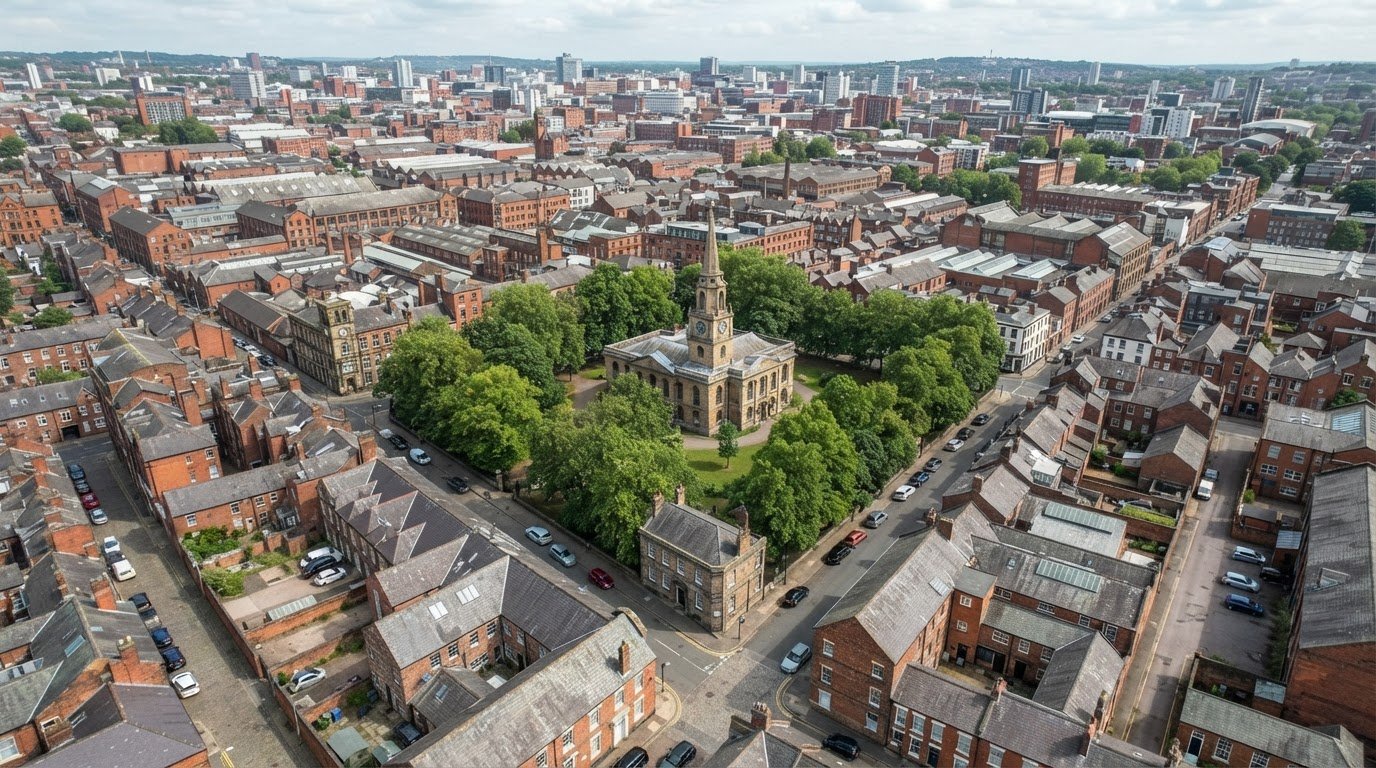
A townscape’s character is shaped by more than its landmark buildings. Aerial photography for townscape assessment reveals how streets, roofs, trees, boundaries and open spaces fit together, helping identify patterns and features that can be difficult to understand from ground level alone. It provides a detailed local view, while satellite imagery gives a broader picture across larger areas.
Ground photographs remain important: they record views from accessible public places and show how people experience a neighbourhood. Aerial photography for townscape assessment adds context, helping reveal how individual features relate to the wider urban form. Neither perspective tells the whole story on its own.
This article explains what aerial photographs can reveal about local character, how they differ from satellite images and where each is most useful. It also explores how to combine aerial and ground-level records for a clearer townscape assessment, including when development proposals may affect nearby buildings, trees or public spaces.
Key Takeaways
- Use satellite imagery to understand wider patterns and aerial photographs to examine the details of a specific site.
- Combine aerial and ground-level records to relate buildings, streets, trees and open spaces to the character people experience.
- Choose image resolution and scale according to the features the assessment needs to show and the decisions it must support.
- A clear survey plan defines the area, viewpoints and imagery needed, helping a professional produce evidence suited to the assessment.
Aerial photography and satellite imagery compared
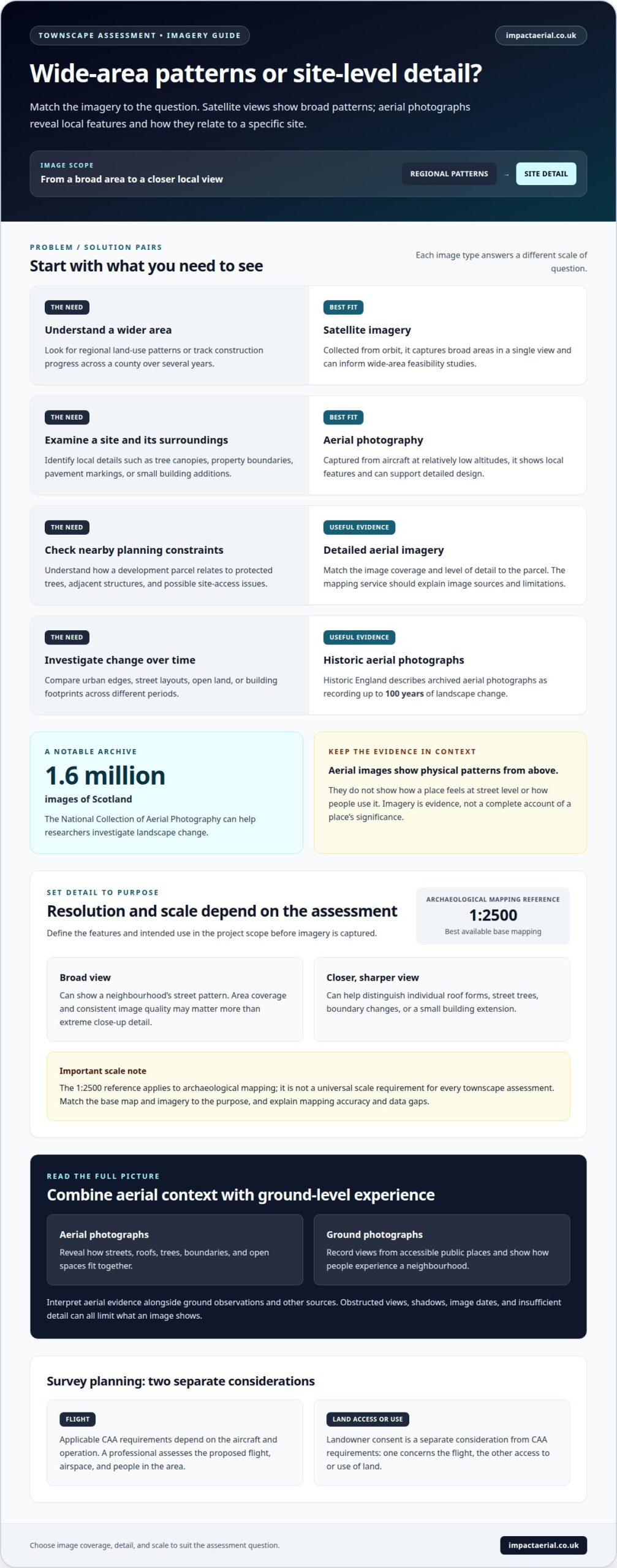
Satellite imagery is collected from orbit, capturing broad areas in a single view. It is useful for regional land-use monitoring and tracking construction progress across a county over several years. Aerial photography, by contrast, uses cameras on aircraft at relatively low altitudes to show local features such as tree canopies, property boundaries, pavement markings and small building additions.
For a planning application layout, detailed aerial imagery can help identify nearby constraints, including protected trees and adjacent structures. It may also reveal potential site access issues. A professional mapping service should match image coverage and detail to the development parcel, explain the imagery’s sources and limitations, and provide mapping suited to the planning work. Satellite data can inform wide-area feasibility studies, while aerial photographs can support detailed design.
Historic imagery adds another perspective. The National Collection of Aerial Photography contains 1.6 million images of Scotland, which can help researchers investigate landscape change. For heritage assessment, aerial views can reveal patterns or features that warrant comparison with historic maps and local records. Imagery is evidence, not a complete account of a place’s significance.
For UK drone photography in built-up areas, applicable CAA requirements depend on the aircraft and operation. A professional assesses the proposed flight, airspace and people in the area before planning the survey. CAA requirements and landowner consent are separate considerations: one concerns the flight, the other access to or use of land.
The Landscape Institute and Institute for Environmental Management and Assessment published the third edition of the Guidelines for Landscape and Visual Impact Assessment in 2013. The Landscape Institute’s Townscape Character Assessment Technical Information Note is 05/2017, revised in April 2018. Camera equipment and settings depend on the required detail, lighting and final use; professionals select them to record the relevant features clearly. Limitations include obstructed views, shadows, image dates and insufficient detail, so aerial evidence should be interpreted alongside ground observations and other sources.
Photographic records of local character and townscape features
A townscape survey uses photographs to record how streets and buildings are experienced from public viewpoints. Baseline photography is taken during the urban survey from readily accessible public places, capturing views that illustrate local character or important features. For example, a view along a high street can show how shopfronts, upper storeys, street trees and signs combine to shape its appearance. A photograph from a square may record how surrounding façades enclose the public space.
These images support written descriptions by showing relationships that feature lists alone can be difficult to convey. A consistent photographic record can include building height and roofline, street width, paving, greenery, landmark structures and transitions between older and newer development. Each image needs a clear viewpoint and direction so readers understand what it documents. Captions identifying the location, view direction and relevant features make photographs useful evidence rather than decoration.
Archived aerial photographs add a time dimension to this record. Historic England describes archived aerial photographs as providing a record of up to 100 years of landscape change. Comparing images from different periods can help show how urban edges, street layouts, open land and building footprints have changed. However, aerial images show physical patterns from above; they don’t capture how a place feels at street level or how people use it.
For heritage work, Historic England recommends integrating information from aerial photographs into Local Historic Environment Records. This can connect visible features with a wider record of historic places and help inform future assessments. Aerial evidence works best alongside ground photographs, historic maps and site observations, with image dates and limitations clearly described. For a project that needs a professionally captured photographic record, a planned aerial survey can provide imagery suited to documenting the site and its surroundings.
What aerial imagery resolution and scale are needed for townscape assessment?
There is no single image resolution or map scale suited to every townscape assessment. The right level of detail depends on the features being examined and how the imagery will be used. A broad view may show a neighbourhood’s street pattern, while a closer, sharper image can help distinguish individual roof forms, street trees or boundary changes. Define these requirements in the project scope before capturing imagery.
Resolution describes how much ground detail an image records. If the assessment needs to identify a small building extension or the canopy of a particular tree, the imagery must show those features clearly enough to interpret. If the aim is to understand how development relates to the wider townscape, area coverage and consistent image quality may matter more than extreme close-up detail. Obstructions, shadows and image angle can also affect visibility.
Scale describes the relationship between mapped features and their real-world size. For archaeological mapping, the best available base mapping is typically at 1:2500 scale and may use Ordnance Survey mapping or georeferenced vertical aerial photographs. This is a useful reference for detailed mapping, not a universal scale requirement for every townscape assessment. A professional should match the base map and imagery to the assessment purpose, then explain the mapping accuracy and any data gaps.
Deliverables matter too. Imagery for a planning layout needs to align with the site boundary and show relevant surrounding features, such as adjacent buildings or trees. Images for a character assessment may instead support comparisons between streets, blocks and open spaces. The chosen level of detail should help readers interpret these relationships without implying an accuracy the imagery cannot support.
Before commissioning a survey, define the assessment area, features to record, required outputs and intended use. These decisions guide image capture and mapping specifications. A clear brief helps ensure aerial photography for townscape assessment provides usable evidence, rather than simply a large collection of high-resolution images.
How to plan an aerial photography survey for a townscape assessment?
Start by defining the assessment area and the decisions the imagery must support. A survey for a proposed building, for example, may need to show its footprint, nearby rooflines and surrounding open spaces. A town-centre character study may focus instead on street blocks, public spaces and the relationship between older and newer development. The brief should specify the required coverage, image formats and intended use of the photographs.
Next, identify the features and views to record. These may include building heights, roof forms, street trees, landmarks and boundaries. Ground-level viewpoints matter too: baseline photography is taken during an urban survey from readily accessible public viewpoints. Together, aerial and ground photographs connect the overall layout with the views people experience on the street.
Then consider practical conditions that affect capture, such as access, visibility, lighting and obstructions. A narrow street, for instance, may hide a roofline behind neighbouring buildings, while shadows can make surface features harder to interpret. The plan should account for these limitations and explain where imagery may not show a feature clearly. This helps prevent a photograph from being treated as evidence of something it cannot establish.
For visual representations of development proposals, the Landscape Institute’s Technical Information Note 06/2019 provides guidance on visual representation. Baseline photography should follow the visualisation type and level stated in Technical Guidance Note 06/19. A professional aligns the capture plan and final images with those requirements, then records the methods, sources and limitations. The resulting set can support assessment alongside maps and written descriptions.
A useful project brief therefore specifies the site boundary, assessment purpose, key features, intended outputs and relevant viewpoints. These details guide survey planning and help shape imagery for the actual task. To arrange professional aerial photography for a townscape project, request an aerial photography survey.
Impact Aerial: Aerial Filming and Photography
Impact Aerial provides aerial filming and photography for projects needing clear, professionally captured views of a site and its surroundings. This service can support townscape work when ground photographs alone do not show how buildings, streets and open spaces relate across an area. A survey brief can identify the assessment boundary, features of interest and intended image use to guide relevant coverage.
Impact Aerial operates commercial-grade professional drones equipped with high-resolution 4K HDR cameras, flown by CAA GVC certified pilots. These capabilities support detailed aerial imagery for development and property projects, with post-production services available to prepare the captured material.
If your project needs aerial photography for a townscape assessment, contact Impact Aerial to discuss the work.
Shape the next stage of your townscape project
Start by defining the decision your assessment needs to inform. Is the priority to understand a proposed building’s relationship with its surroundings, establish a clear project record, or support discussion about local character? A focused brief helps ensure the imagery provides relevant evidence and fits the wider assessment, rather than becoming an isolated set of pictures.
When planning aerial photography for townscape assessment, consider how the finished images will be interpreted alongside written analysis, plans and other project material. Clear objectives also help a professional plan coverage around the site and the features relevant to your work. This creates a more useful foundation for communicating change and considering its context.
If you’re ready to discuss the imagery your project needs, talk through your project with Impact Aerial. A clear starting brief can help move your assessment forward with purpose.
Frequently Asked Questions
What is aerial photography used for in townscape assessment?
Aerial photography helps assess how a proposed change relates to the form and setting of an urban area. Overhead views can show block patterns, building massing and transitions between built-up streets and open land. For example, imagery can help assess whether a new development sits within an established urban edge or changes the relationship between a town centre and nearby green space.
How can a professional use aerial photographs to assess urban character, views and heritage assets?
Interpret aerial photographs alongside site observations and heritage records, rather than treating an image as a complete assessment. Comparing roof forms, building groups and street patterns can help identify how a townscape’s character varies between areas. For a heritage asset, imagery can show its spatial relationship with surrounding development, while ground-level views help assess its prominence and how people experience it.
How does aerial photography compare with satellite imagery and ground surveys?
Aerial photography can provide closer views of a defined site, while satellite imagery helps reveal broader geographic patterns. A ground survey adds details an overhead image cannot establish, such as how a street feels at pedestrian level or how buildings frame a particular view. Combining these forms of evidence connects site context with people’s experience of place.
What aerial imagery and mapping data are available for UK towns?
Available sources vary by location and date. For Scotland, the National Collection of Aerial Photography holds 1.6 million aerial images. Other useful records include the Historic England Archive, the Cambridge University Collection of Aerial Photography and local collections. Assessment work can also draw on historic, soils and geology maps, Local Historic Environment Records, lidar and online imagery such as Google Earth.
 2 Norton Drive, Wythall, Birmingham, B47 6HH Company registration number: 11138586. VAT Number: 366 9068 55


