
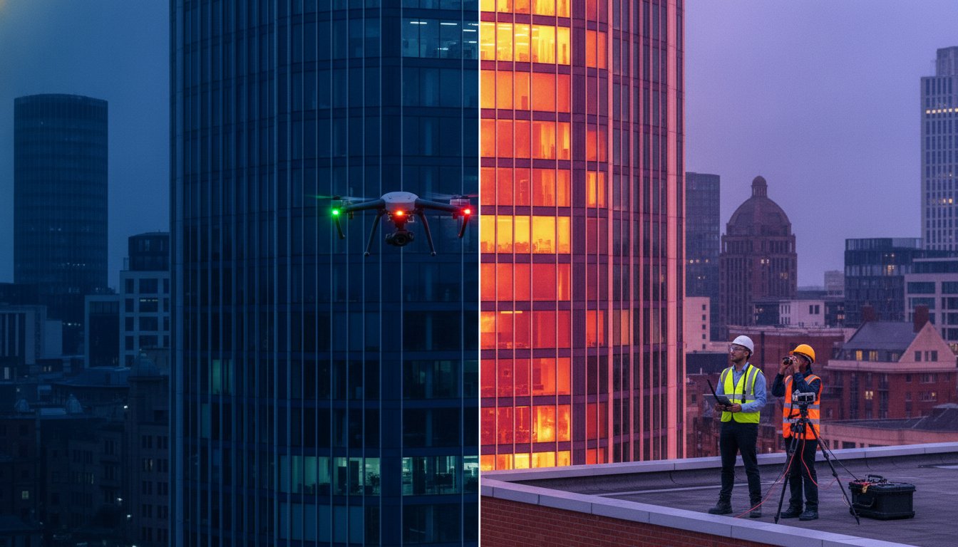
What if you could identify every hidden structural defect and heat leak in your facility without ever erecting a single piece of scaffolding? For many UK property managers, the true cost of maintenance isn’t just the repair itself, but the expensive and often dangerous manual inspections required to find the source of the problem. You likely already know that rising energy costs and undetected water ingress are silent threats to your asset’s value. It’s frustrating to pay for high-access equipment just to confirm a suspected leak or identify thermal bridges that remain invisible to the naked eye.
This 2026 guide explains how professional thermal drone building inspections UK services provide a sophisticated, non-invasive solution to these operational challenges. We’ll show you how high-resolution aerial thermography identifies structural defects while ensuring your property data meets the latest regulatory standards, including mandatory Remote ID and night-flight lighting requirements. You’ll discover how to generate a clear map of heat loss for EPC improvements and secure the precise evidence needed for insurance claims. We’ll also cover the essential safety protocols and CAA GVC certifications that define a professional, compliant operation in a highly regulated industry.
Key Takeaways
- Identify invisible structural threats like moisture trapped in flat roofs and thermal bridging that standard visual surveys often miss.
- Learn how radiometric sensors on DJI Enterprise drones provide precise temperature data for every pixel, ensuring high-tier accuracy in defect detection.
- Navigate the updated 2026 legal requirements for thermal drone building inspections UK, including mandatory Remote ID and CAA GVC certification.
- Discover how professional aerial reports provide the technical evidence needed for insurance claims, EPC improvements, and long-term asset management.
- Reduce maintenance overheads and safety risks by replacing traditional scaffolding with a faster, non-invasive surveying alternative.
Why Thermal Drone Building Inspections are Essential for UK Property
Aerial thermography is the process of using infrared sensors to detect and map temperature variations across a building’s envelope. By capturing the thermal radiation emitted by surfaces, these sensors identify anomalies that remain invisible to the naked eye. Understanding How Aerial Thermography Works is fundamental for property managers who need to diagnose structural health without invasive testing. In the UK, the 2026 business environment places a heavy emphasis on achieving Net Zero targets. Thermal drone building inspections UK wide are now a primary tool for validating energy efficiency and ensuring that commercial assets maintain high EPC ratings to preserve their market value.
To better understand this concept, watch this helpful video:
The shift toward proactive maintenance is driven by the need to identify “invisible” defects before they escalate into structural failures. Moisture trapped within the insulation of a flat roof or thermal bridging in a building’s elevations can go unnoticed for years. These issues don’t just cause structural decay; they represent a significant drain on operational budgets through heat loss and increased insurance premiums. By detecting these temperature signatures early, owners can mitigate risks and protect the long-term integrity of their property.
The Cost of “Not Knowing”: Hidden Building Risks
Minor leaks often transition into major structural failures when they’re left undetected by standard visual surveys. In large-scale industrial units, energy inefficiency is a silent financial drain that compounds over time. While ground-based thermography is useful for internal checks, it often fails on high-rise structures or complex roof layouts where “point and shoot” angles are obstructed. Aerial data provides a comprehensive top-down view, ensuring no cold spots or moisture pockets are missed during the diagnostic process.
Drone Surveys vs. Traditional Access Methods
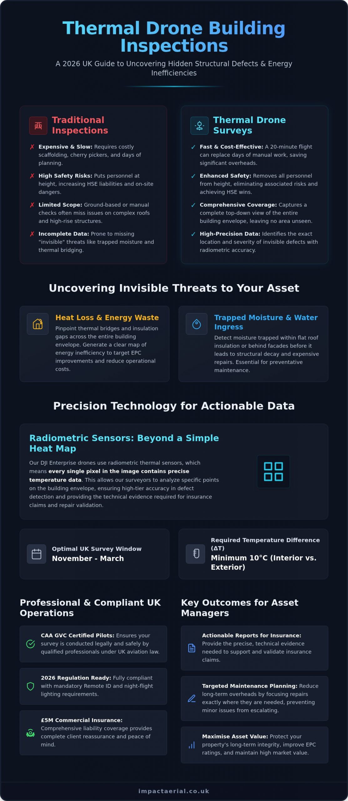
The efficiency gains of modern aerial technology are undeniable. A 20-minute flight can capture data that would traditionally require days of planning, scaffolding, or expensive cherry picker hire. From a health and safety perspective, removing personnel from height is a significant HSE win that reduces on-site risk. This drone survey technology has disrupted traditional surveying timelines by delivering high-resolution, actionable data in a fraction of the time. By choosing a professional operator with CAA GVC certification and £5m commercial liability insurance, clients receive the reassurance that their survey is both technically accurate and fully compliant with UK aviation law.
The Technology: How Aerial Thermography Works
Professional thermal drone building inspections UK rely on commercial-grade DJI Enterprise hardware equipped with high-resolution radiometric sensors. Unlike basic thermal cameras that merely display a heat map, radiometric sensors record the specific temperature of every individual pixel within the frame. This data-centric approach allows surveyors to interrogate the imagery during post-processing, extracting precise thermal readings from any point on the building envelope. To achieve this level of accuracy in the UK climate, we typically require a “Delta T” (temperature difference) of at least 10°C between the building’s interior and the external environment. This makes the winter months, specifically from November to March, the optimal window for identifying significant heat loss or insulation gaps.
Radiometric Data and Temperature Accuracy
Capturing reliable thermal data requires more than just flying a drone. Factors such as surface emissivity and atmospheric conditions significantly influence the quality of the readings. In a professional UK setting, we account for these variables using advanced post-processing software that calibrates the raw data into detailed thermographic reports. Consumer-grade drones often lack the sensor sensitivity and radiometric capabilities needed for this level of analysis. By following the latest guidance on Navigating UK Drone Regulations and Safety Standards, professional operators ensure that data is collected safely and to a technical standard that architects and engineers can trust.
Visual Context: 4K HDR and Zoom Capabilities
Thermal data rarely tells the whole story on its own. A “hot spot” on a roof could indicate a serious internal leak, but it could also be a patch of moss or a reflective surface. Our dual-sensor approach captures 4K HDR visual imagery alongside the thermal feed to provide essential context. High-zoom visual cameras allow our pilots to perform detailed snagging and inspection from a safe distance, removing the need to fly dangerously close to the structure. This combination of visual and thermal data provides a comprehensive evidence base for insurance claims or structural repairs. For complex assets, Impact Aerial’s specialized surveying provides the technical clarity needed for informed decision-making without the high costs of traditional access.
Detecting Hidden Defects: From Heat Loss to Water Ingress
The practical application of thermal drone building inspections UK wide extends far beyond simple heat maps. By leveraging the physical principles of thermal mass and solar loading, professional surveys identify specific structural failures that remain hidden during standard visual inspections. This technology is particularly effective for large-scale assets, including commercial warehouses and complex industrial units. Beyond the building envelope, specialized sensors are also used for PV solar farm thermal surveys to identify bypassed or faulty cells, ensuring maximum energy yield and preventing fire risks caused by localized hotspots.
Flat Roof Moisture Mapping
Flat roofs are notorious for hidden water ingress that can compromise structural integrity. Professional surveys utilize the concept of thermal mass to map moisture pockets within insulation layers. During a sunny day, the entire roof structure absorbs solar energy. After sunset, dry insulation cools rapidly, while wet insulation, which has a higher thermal mass, retains heat for much longer. By conducting a survey during this specific post-sunset window, we visualize the “thermal signature” of trapped water with high precision. This data is invaluable for insurance claims and planned preventative maintenance (PPM), allowing for targeted repairs rather than expensive, full-roof replacements.
Building Envelope and Insulation Surveys
Thermal drones provide a non-invasive method to verify the real-world performance of a building’s envelope against design specifications. We frequently identify missing cavity wall insulation or defective cladding panels that compromise a structure’s U-value. These surveys also highlight snags in HVAC systems and external pipework where insulation has degraded, leading to significant energy waste. For UK property managers, this level of detail is essential for meeting modern sustainability standards and reducing operational overheads. When inspecting UK warehouses and industrial facilities, our pilots typically identify several recurring issues:
- Thermal Bridging: Heat escaping through structural steelwork or poorly insulated window frames.
- Compressed Insulation: Areas where insulation has settled or been incorrectly installed, reducing its R-value.
- Air Leakage: Unintended gaps in the building fabric, often found around loading bay doors or roof lights.
- HVAC Duct Failures: Leaks in external ductwork that force heating and cooling systems to overcompensate.
- Sub-surface Moisture: Trapped water in roof membranes that leads to long-term structural decay if left unaddressed.
By identifying these issues early, businesses can move from reactive repairs to a more strategic, data-driven maintenance model. Our CAA GVC certified pilots use commercial-grade DJI Enterprise hardware to ensure every survey is delivered with the precision required by surveyors and structural engineers.
Navigating UK Drone Regulations and Safety Standards
Safety and legal compliance are the foundational pillars of professional thermal drone building inspections UK wide. In a highly regulated aviation environment, conducting aerial surveys requires more than just high-end hardware; it demands a deep understanding of the Civil Aviation Authority (CAA) framework. For property managers and industrial site owners, ensuring your contractor operates within the law is essential for risk mitigation and maintaining the validity of your own corporate insurance policies. Professional operators don’t just fly; they manage complex aerial operations that prioritize the safety of people and property on the ground.
CAA GVC Certification Explained
There’s a significant legal distinction between hobbyist flyers and those authorized for commercial work. Under the current CAA drone regulations, any pilot conducting building inspections for “valuable consideration” must hold a General Visual Line of Sight Certificate (GVC). This isn’t a simple online test. A GVC-certified pilot undergoes rigorous theoretical training and a practical flight assessment specifically designed for operating in congested urban and industrial areas. Hiring an uncertified pilot is a major liability; it risks heavy fines from the CAA and almost certainly voids your business insurance should an incident occur. Our pilots are fully GVC certified, ensuring every survey is conducted with the technical discipline required for complex UK environments.
Insurance and Risk Mitigation
Standard public liability insurance is insufficient for commercial drone operations. The industry standard for professional thermal drone building inspections UK is £5m commercial liability insurance, which is specifically tailored to cover aerial risks on industrial and urban sites. This level of coverage provides psychological comfort and tangible financial protection for our clients. Every project begins with a methodical risk management process, including:
- Pre-flight Planning: Detailed site surveys and check of airspace restrictions.
- NOTAMs: Filing “Notices to Airmen” where necessary to alert other aircraft to our presence.
- On-site Safety: Establishing cordons and emergency landing zones.
- GDPR Compliance: Managing privacy concerns by using data-centric processes that redact or avoid capturing identifiable personal information in populated areas.
This meticulous approach ensures that we deliver high-tier data while strictly adhering to safety protocols. If you require a survey that meets the highest professional standards, you can secure your compliant project with Impact Aerial’s drone commercial property surveys today.
Maximising Asset Value with Impact Aerial’s Surveying
Impact Aerial combines deep technical expertise with commercial-grade DJI Enterprise technology to deliver high-tier results for every client. While our operations are headquartered at our Birmingham base, we provide nationwide coverage, serving the entire UK with the same meticulous attention to detail. We position thermal drone building inspections UK as a strategic investment in a building’s long-term lifecycle rather than a simple maintenance check. By identifying issues early, we help asset managers bridge the gap between raw data and informed structural decision-making. Our Birmingham base allows us to respond rapidly to West Midlands projects, though our logistical capabilities ensure we maintain a consistent presence across the country. Using DJI Enterprise hardware means we capture 4K HDR visual data alongside radiometric thermal feeds, ensuring that every report is underpinned by high-quality evidence.
From Data to Actionable Reports
A professional survey is only as effective as the data it produces. Our clients receive a comprehensive suite of deliverables, including high-resolution thermal maps, detailed visual snagging lists, and expert analysis of identified anomalies. These reports are structured to integrate directly into modern Building Information Modelling (BIM) workflows. This allows structural engineers and facility managers to overlay radiometric data onto existing digital twins or structural plans for a complete view of building health. Our specialized post-production services ensure that complex thermal data is distilled into a professional format that is ready for insurance submissions or internal stakeholder reviews. We focus on providing a clear, evidence-based narrative that justifies maintenance spends and informs long-term capital planning for complex industrial and commercial assets.
The ROI of Aerial Thermography
The return on investment for aerial thermography is measured in both capital savings and operational efficiency. By isolating specific areas of moisture ingress or insulation failure, property owners can perform targeted repairs instead of committing to the high costs of full roof replacements. This data-centric approach significantly reduces the carbon footprint of a facility, directly aligning with the UK’s 2026 sustainability and Net Zero objectives. Better thermal management leads to improved EPC ratings, which directly enhances the market value of commercial property. Identifying a single failed HVAC duct or a pocket of wet insulation early can save thousands in energy waste and secondary structural damage. If you are ready to secure your asset’s future and reduce your maintenance overheads, you can Request a quote for thermal building inspections from Impact Aerial to begin your survey process.
Securing Your Property Assets Through Aerial Innovation
The landscape of property maintenance in 2026 demands a shift from reactive repairs to data-driven asset management. By integrating thermal drone building inspections UK into your surveying workflow, you gain the ability to visualize invisible structural threats before they escalate into costly failures. From identifying moisture trapped within flat roof insulation to pinpointing energy inefficiencies that impact your EPC rating, aerial thermography provides a non-invasive and high-precision alternative to traditional scaffolding.
Operating with technical excellence and total compliance is the foundation of our service. Our CAA GVC certified pilots utilize expert DJI Enterprise technology to capture radiometric data that structural engineers and insurers can trust. With £5m commercial liability insurance as standard, we provide the psychological comfort and operational security required for complex industrial and urban environments. Don’t leave your building’s health to chance; invest in a surveying solution that protects your long-term ROI and supports your sustainability goals. Book Your Professional Thermal Drone Survey Today and take the first step toward a safer, more efficient property portfolio. We look forward to helping you secure your assets with precision.
Frequently Asked Questions
What is the best time of year for a thermal drone building inspection in the UK?
The optimal time for thermal drone building inspections UK wide is during the winter months, typically between November and March. Accurate results require a significant temperature difference, or “Delta T,” between the building’s interior and the external environment. We usually perform these surveys at night or in the early morning. This timing avoids solar radiation interference and ensures that heat loss or moisture pockets are clearly visible to the radiometric sensors.
Can a thermal drone see through walls or roof materials?
Thermal sensors don’t see through walls or roof materials in the way an X-ray would. Instead, they detect infrared radiation emitted from the surface. By measuring these temperature variations, we identify sub-surface anomalies. For example, wet insulation has a higher thermal mass and retains heat longer than dry materials. This creates a distinct thermal signature on the surface that reveals hidden water ingress without requiring invasive physical testing.
How much does a thermal drone building survey cost in the UK?
The cost of a professional survey varies significantly based on the structure’s size, location, and complexity. Commercial inspections for large industrial units or high-rise buildings require more flight time and data processing than smaller residential projects. Rather than searching for a flat rate, property managers should request a bespoke quote that includes CAA-compliant flight planning and detailed radiometric reporting. This ensures you receive high-tier data that meets insurance and structural engineering standards.
Do I need to notify my neighbours or local council before a drone inspection?
You aren’t legally required to notify the local council for most standard thermal drone building inspections UK operations. However, professional pilots always conduct a site-specific risk assessment and may inform immediate neighbours as a courtesy. If the flight occurs in restricted airspace, we handle the necessary NOTAM filings with the CAA. We also follow strict GDPR protocols to ensure that identifiable personal data is redacted or avoided during the surveying process.
What is the difference between a visual drone survey and a thermal one?
A visual drone survey uses standard RGB cameras to capture high-resolution 4K imagery of visible snags like cracked tiles or damaged cladding. In contrast, a thermal survey uses infrared sensors to map heat signatures. At Impact Aerial, we use a dual-sensor approach. This allows us to overlay thermal data onto visual imagery, providing essential context so we don’t mistake a reflective surface or a patch of moss for a genuine structural defect.
How long does it take to get the results of a thermal drone inspection?
While the flight itself might only take twenty to forty minutes, generating an actionable report takes longer. We typically deliver the final results within forty-eight to seventy-two hours. This window allows our technical team to perform radiometric post-processing and expert analysis. We ensure the data is formatted for Building Information Modelling (BIM) workflows, providing you with a professional document that is ready for engineers or insurance adjusters to review.
Are thermal drone inspections accurate for identifying flat roof leaks?
Aerial thermography is exceptionally accurate for identifying moisture ingress in flat roofs. It relies on the principle that wet insulation holds heat longer than dry insulation. By surveying the roof after sunset, we can clearly see the “hot spots” where moisture is trapped. This method allows for targeted repairs, which often prevents the need for a total roof replacement. It’s a highly effective tool for planned preventative maintenance.
What qualifications should I look for when hiring a drone pilot for a building survey?
When hiring a pilot, you must verify they hold a current CAA GVC (General Visual Line of Sight) certification for commercial work. This ensures they’ve undergone rigorous training for urban and industrial environments. You should also confirm they carry at least £5m in commercial liability insurance. Finally, look for operators who use professional-grade DJI Enterprise drones and have experience in radiometric data analysis, as hobbyist-level equipment cannot provide the accuracy required for structural surveys.
 2 Norton Drive, Wythall, Birmingham, B47 6HH Company registration number: 11138586. VAT Number: 366 9068 55


