

What if the most significant risk to your project isn’t the flight itself, but the thousands of raw images left sitting idle on a server? You’ve likely felt the overwhelm of navigating a massive data dump without a structured way to extract value. It’s a common frustration; the transition from aerial capture to actionable intelligence often feels like a “black box” that delays critical maintenance decisions and leaves you questioning the return on your investment.
We’re going to demystify the complete data lifecycle, showing you how professional drone survey deliverables move through a meticulous pipeline of processing and expert analysis. You’ll gain a clear understanding of the reporting timeline, the accuracy of modern AI-assisted defect detection, and the technical standards required for seamless BIM integration. By the end of this guide, you’ll have the confidence to turn raw aerial data into precise business intelligence that helps you plan your maintenance budget with total certainty.
Key Takeaways
- Learn how immediate on-site data integrity checks eliminate “blind spots” and ensure every critical asset is captured before the flight team leaves the site.
- Understand the technical process of photogrammetry and AI-assisted analysis that converts thousands of raw images into high-resolution, measurable intelligence.
- Discover the specific drone survey deliverables you will receive, from detailed PDF defect reports to orthomosaic maps, and how they help prioritise urgent repairs.
- Find out how to seamlessly integrate aerial CAD files and 2D maps into your existing asset management software to justify maintenance budgets with visual evidence.
- Explore why professional post-production and regulatory compliance are essential for creating legally defensible reports that satisfy UK safety and insurance standards.
From Flight to File: The Immediate Post-Inspection Data Workflow
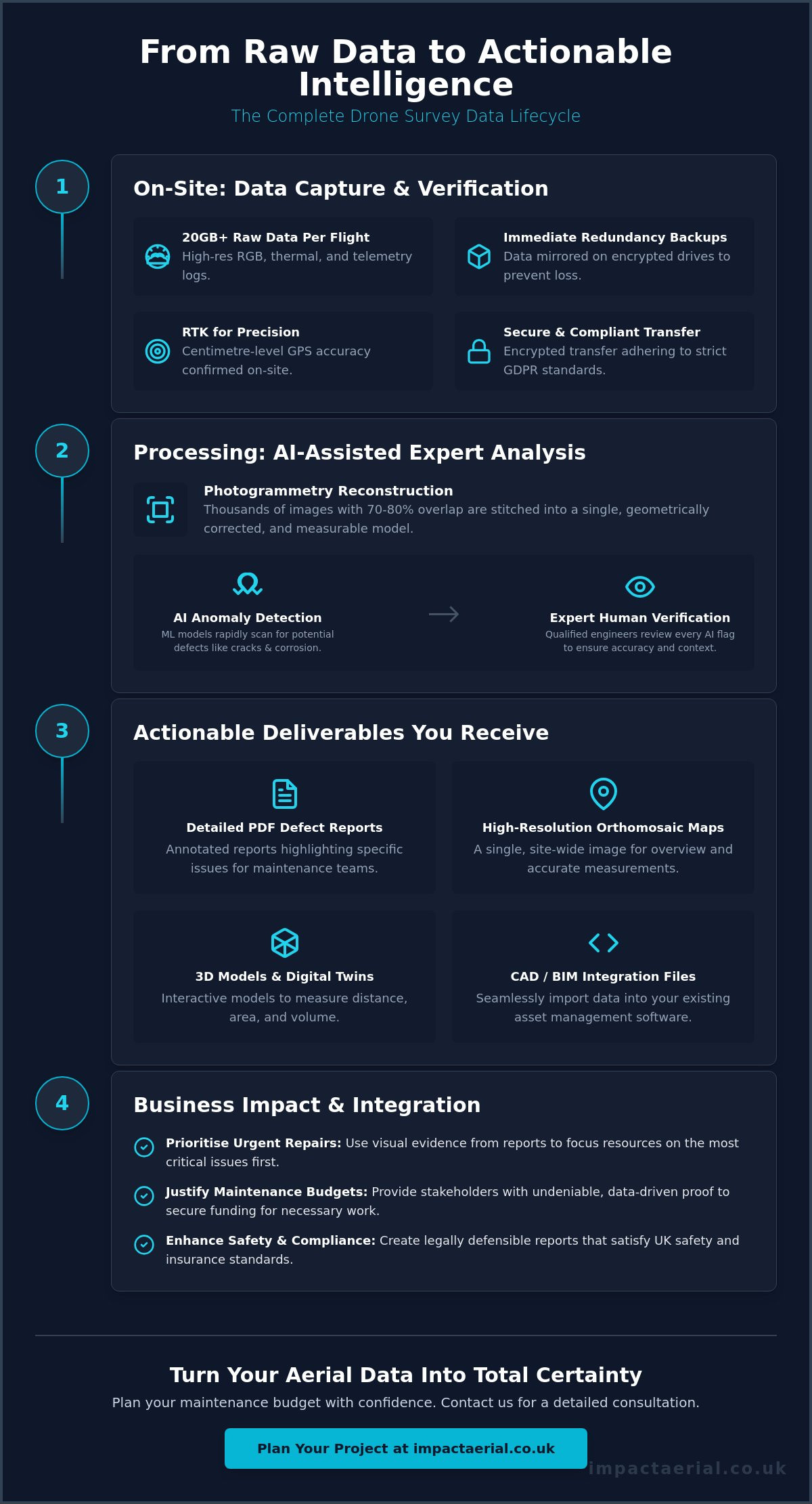
The moment a drone returns to its landing pad marks the end of the aerial mission, but it’s only the beginning of the data lifecycle. A single professional inspection can easily generate upwards of 20GB of raw data, consisting of high-resolution imagery, thermal frames, and complex telemetry logs. Managing this volume requires more than just a large memory card; it demands a structured workflow to ensure the resulting drone survey deliverables are accurate and complete. Professional teams initiate immediate redundancy backups on-site, mirroring data across multiple encrypted drives to eliminate the risk of hardware failure or data loss during transit.
Organisation starts in the field. Pilots categorise imagery into distinct streams: Visual (RGB) for structural detail, Thermal for heat signatures, and Metadata files that record the drone’s exact position in three-dimensional space. This metadata is the “digital glue” that allows photogrammetry software to later stitch thousands of individual photos into a cohesive, measurable model. Without this meticulous onsite organisation, the processing phase becomes a bottleneck that delays your final report.
To better understand the complexity of these outputs, watch this helpful overview of drone job deliverables:
Data Integrity and Verification
Ensuring there are no “blind spots” is a critical safety and quality protocol. Before leaving the site, the flight team performs a data integrity check to verify that every waypoint and asset angle was captured according to the pre-flight plan. We rely on RTK (Real-Time Kinematic) data to confirm GPS accuracy, often achieving centimetre-level precision. This rigorous verification prevents the need for costly re-flights, ensuring that the drone survey deliverables you receive are based on a complete and flawless dataset.
Secure Data Transfer Protocols
Handling sensitive infrastructure data requires a commitment to security and confidentiality. Once the integrity check is complete, data is transferred via encrypted drives or secure cloud uploads. In the UK, this process must strictly adhere to GDPR standards, especially if the drone has incidentally captured identifiable third-party information or private property. Once the field team confirms the secure transfer, the dataset moves to our post-production and analysis specialists, who begin the work of turning raw pixels into business intelligence.
Analysis and Interpretation: Turning Raw Imagery into Actionable Intelligence
Processing raw imagery is where a massive dataset transforms into high-value drone survey deliverables. We utilise photogrammetry to align hundreds or even thousands of overlapping images, typically captured with a 70 to 80 percent overlap, to create a single, geometrically corrected map. This isn’t a simple photo-stitch; it’s a rigorous mathematical reconstruction where every pixel is assigned a spatial coordinate. This foundation allows stakeholders to take accurate measurements of distance, area, and volume directly from their desktop, providing a level of site-wide oversight that traditional ground inspections cannot match.
Once the digital foundation is set, AI-assisted algorithms scan the dataset for structural anomalies. Machine learning models are trained to recognise specific patterns of corrosion, hairline cracks in concrete, or missing components in complex steel structures. This automated layer significantly reduces the time required to process large-scale assets, ensuring that critical issues are surfaced within hours rather than weeks. However, the true value lies in the marriage of this speed with expert oversight.
AI vs. Human Expertise in Asset Review
While machine learning provides incredible speed, it cannot replace the nuanced judgement of a qualified professional. Every anomaly flagged by the software undergoes a rigorous verification process by a CAA GVC certified pilot or surveyor to eliminate false positives and assess the real-world risk. Defect tagging is the process of geolocating specific issues on a digital twin to provide exact coordinates for repair teams. This human-led validation ensures that your maintenance budget is allocated based on verified, high-risk findings rather than automated guesses. For those managing complex portfolios, our drone commercial property surveys provide the expert oversight needed to turn these insights into a long-term maintenance strategy.
Thermal Data Interpretation
For specialised assets like PV solar farms or industrial roofing, thermal interpretation adds a critical layer of intelligence. We analyse thermographic imagery to detect subtle heat signatures that indicate energy loss, water ingress, or electrical faults. On solar farms, this allows us to identify individual cell failures that are invisible to the naked eye. The severity of these faults is determined by the “temperature delta”, which is the difference in temperature between the fault and the surrounding healthy area. A high delta indicates a critical failure that requires immediate intervention to prevent fire risks or significant yield loss.
By comparing this current data against historical baselines, we can track asset degradation over time. This longitudinal analysis allows you to see if a small crack identified six months ago has widened, providing the visual evidence needed to move from expensive reactive repairs to cost-effective predictive maintenance. This methodical approach ensures that every flight delivers a clear, evidence-based roadmap for your facility management team.
Understanding Your Deliverables: What Clients Receive After the Survey
Once the analysis is complete, the raw data is distilled into a comprehensive suite of professional outputs. These drone survey deliverables are designed to provide both high-level executive summaries for stakeholders and granular technical data for engineering teams. The cornerstone of this package is the Detailed PDF Inspection Report. This document categorises identified defects by severity, allowing asset managers to prioritise maintenance budgets based on visual evidence rather than guesswork. Each defect is accompanied by annotated high-resolution imagery; these are the direct “close-up” shots that provide contractors with the visual context they need to quote for repairs accurately.
For site-wide documentation, we provide Orthomosaic Maps. Unlike a standard aerial photograph, an orthomosaic is a geometrically corrected 2D map where every pixel is measurable. These high-resolution files allow you to calculate distances and surface areas across your entire site with professional-grade accuracy. It’s a vital tool for site documentation that remains relevant long after the flight team has left the area.
3D Models and Digital Twins
The most immersive of the drone survey deliverables is the 3D digital twin. These navigable models allow stakeholders to “walk through” an asset from their desktop, which is particularly valuable for remote site management or presenting findings to international boards. In UK construction projects, we deliver point clouds that integrate directly into BIM (Building Information Modelling) workflows. These point clouds consist of millions of geolocated data points, providing the architectural and engineering measurements required for precise structural analysis. They ensure your digital twin adheres to the strict data standards expected in high-tier UK engineering environments. You can learn more about the technical foundations of these outputs in our guide to drone survey methodologies.
Interactive Client Portals
Modern asset management has moved beyond static files. We provide access to interactive cloud-based portals where clients can zoom, annotate, and measure data in real-time. This dynamic environment allows you to share specific defect “tags” directly with repair contractors, significantly streamlining the procurement process. One of the most powerful features is the timeline tool. By overlaying data from multiple surveys, you can view “before and after” comparisons of construction progress or monitor how a specific structural issue is developing over several months. This level of transparency ensures that all stakeholders are working from a single, verified source of truth.
Integrating Drone Data into Your Asset Management Strategy
Data only becomes intelligence when it’s integrated into your existing business processes. For asset managers and project leads, the true value of drone survey deliverables lies in their ability to feed directly into Enterprise Resource Planning (ERP) and project management systems. To see how digital tools can optimize these workflows, visit GoBuid and discover their platform for construction site documentation and reporting. Instead of treating aerial data as a standalone report, professional organisations use these outputs to justify maintenance budgets and prioritise urgent repairs based on undeniable visual evidence. This integration reduces “Time to Action” by providing procurement teams with the exact technical specifications and visual context they need to secure competitive repair quotes quickly.
In the UK, maintaining a rigorous visual record is increasingly vital for insurance and regulatory compliance. Whether you’re managing a commercial portfolio or a complex infrastructure project, having a geolocated, time-stamped record of asset condition provides a “Visual Audit Trail”. This documentation is indispensable during safety inspections, insurance renewals, or future asset sales, as it proves a proactive approach to risk mitigation and structural integrity.
BIM and CAD Integration
Modern engineering workflows require data that fits seamlessly into existing software environments. We provide drone survey deliverables in industry-standard formats such as .OBJ, .LAS, and .DXF, ensuring they are ready for immediate import into CAD and BIM platforms. This allows your team to compare the “As-Built” reality on-site against the original design models, identifying discrepancies before they lead to costly construction delays. For a deeper look at the hardware that makes this centimetre-level precision possible, see our survey drone guide for professionals.
Predictive Maintenance Planning
The most sophisticated use of drone data involves moving from reactive fixes to predictive maintenance. By analysing year-on-year aerial data, you can track the degradation rate of high-value assets, such as roofing systems or industrial chimneys. Seeing a hairline crack or a patch of corrosion develop over twelve months allows you to predict when a structure is likely to fail. The cost-benefit of detecting these issues early is significant; it’s often the difference between a minor £5,000 localised repair and a £50,000 emergency structural intervention. If you’re ready to transition to a more efficient, data-driven maintenance model, contact Impact Aerial to discuss your specific site requirements.
This strategic approach ensures your data isn’t just stored in a folder, but is actively working to protect your assets and your bottom line. By embedding these insights into your long-term strategy, you create a more resilient and transparent management process that satisfies both internal stakeholders and external regulators.
The Impact Aerial Standard: Professional Post-Production and Compliance
The final stage of the data lifecycle is where technical accuracy meets professional presentation. While the previous sections focused on the extraction and analysis of information, the concluding phase ensures that your drone survey deliverables are accessible to every stakeholder, from site engineers to board-level directors. Raw data can be overwhelming; professional post-production editing distils these massive datasets into clear, digestible formats that highlight critical findings without sacrificing technical depth. This process bridges the gap between complex engineering files and the high-level executive summaries required for commercial decision-making.
Every project concludes with a formal close-out meeting and a structured data handover. We don’t just send a download link; we walk you through the findings to ensure your team understands how to navigate the digital twins and interpret the defect logs. This ensures that the investment in aerial intelligence translates directly into a more efficient maintenance workflow and a clearer understanding of your asset’s health.
Beyond Raw Data: Cinematic and Virtual Tours
For many clients, the value of a drone mission extends beyond structural analysis into property marketing and stakeholder engagement. We use 4K HDR imagery to create immersive virtual tours that allow viewers to explore a site remotely with incredible clarity. By combining technical survey data with our high-end aerial filming drone capabilities, we provide a dual-purpose product. This approach is particularly effective for presenting survey findings to directors who require a visually engaging overview of a project’s progress or an asset’s condition without needing to sift through thousands of individual inspection frames.
Compliance and Liability Assurance
In the professional drone industry, data is only as valuable as its legal defensibility. Hiring certified pilots isn’t just about skill; it’s about ensuring your data is gathered under strict regulatory oversight. We maintain £5m commercial liability insurance to protect our clients’ interests throughout the project lifecycle. This level of coverage, combined with meticulously archived flight logs and risk assessments, provides a robust safety record for your corporate archives. Choosing a provider with professional drone services certification acts as a critical safety net, ensuring that your drone survey deliverables meet the highest UK industry standards for safety and data integrity. This commitment to compliance ensures that your data remains a reliable asset in the event of insurance claims or regulatory audits.
Moving from Raw Data to Strategic Intelligence
The lifecycle of aerial data doesn’t end when the drone lands; it’s the sophisticated processing and expert interpretation that turns pixels into profit. You’ve seen how professional drone survey deliverables provide a visual audit trail that justifies maintenance budgets and satisfies UK regulatory standards. By integrating high-resolution 3D models and orthomosaic maps into your existing asset management strategy, you move from reactive repairs to a cost-effective predictive model.
Ensuring this data is accurate and legally defensible requires a partner who prioritises compliance as much as technology. We combine 4K HDR enterprise-grade drone hardware with the expertise of CAA GVC certified pilots to deliver industry-leading results. With £5m commercial liability insurance as standard, you can be certain your assets and data are in safe, expert hands. Ready to transform your site oversight with precision intelligence? Request a professional drone inspection consultation from Impact Aerial today. Let’s build a clearer, safer future for your asset portfolio.
Frequently Asked Questions
How long does it take to receive the drone inspection report?
Standard delivery for a professional inspection report is typically between three and five working days. This duration allows for the meticulous processing of raw data, AI-assisted defect detection, and a final manual review by a certified specialist. For larger industrial sites or complex 3D reconstructions, we provide a specific delivery schedule during the initial project planning phase to ensure your maintenance timelines are met.
What file formats will I receive after a drone survey?
You will receive a comprehensive suite of drone survey deliverables in industry-standard formats. These typically include high-resolution PDF inspection reports for executive review, georeferenced TIF or JPG orthomosaic maps, and 3D point clouds in .LAS or .OBJ formats. For engineering teams, we also provide .DXF files that are ready for immediate import into CAD software, ensuring the data is useful across your entire organisation.
Do I need special software to view the 3D models or orthomosaics?
You don’t need any specialised software to view the primary findings, defect tags, or high-resolution imagery. We provide access to interactive, cloud-based portals that allow you to view, zoom, and take basic measurements of your data directly within a standard web browser. While technical teams will use CAD or BIM software for deeper analysis, the core intelligence is accessible to any stakeholder with an internet connection.
Can drone data be integrated into my existing BIM or CAD software?
Yes, all professional aerial data is designed for seamless integration into existing BIM and CAD software environments. By providing technical files in formats like .DXF, .OBJ, and .LAS, we ensure that the digital twin of your asset can be overlaid directly onto your original design models. This capability is essential for identifying discrepancies between the “as-built” reality and the design intent on complex construction sites.
How accurate is the measurement data from a drone inspection?
Professional drone surveys typically achieve a vertical and horizontal accuracy of 1cm to 3cm. We reach this level of precision by using RTK (Real-Time Kinematic) technology and strategically placed ground control points during the flight. This ensures that the volumetric calculations, surface area measurements, and distance data provided in your deliverables are accurate enough for professional engineering and maintenance budgeting.
Is the data captured by drones legally admissible for insurance claims in the UK?
Aerial data is legally admissible for insurance and legal purposes in the UK provided the mission is conducted by CAA GVC certified pilots. Because our survey data is geolocated and time-stamped, it provides a verified visual audit trail of an asset’s condition at a specific point in time. This transparency, supported by our £5m commercial liability insurance, offers the robust evidence required by insurers and loss adjusters.
What happens if the drone finds a critical defect during the flight?
If a critical defect is identified during the flight, our team will notify you immediately. While the comprehensive data processing takes several days, our pilots monitor the live feed in real-time and can flag urgent structural failures or safety risks while still on site. This immediate notification allows you to initiate emergency repairs or safety protocols without waiting for the final processed report to be delivered.
How is my data stored and kept secure after the inspection?
Your data is stored using high-level encryption on secure, UK-based cloud servers. We adhere strictly to UK GDPR standards to ensure the privacy and confidentiality of all captured information. Following the project close-out, we maintain secure archives of your flight logs and survey results, providing a long-term safety record that your team can reference for future maintenance planning or historical asset comparisons.
 2 Norton Drive, Wythall, Birmingham, B47 6HH Company registration number: 11138586. VAT Number: 366 9068 55


