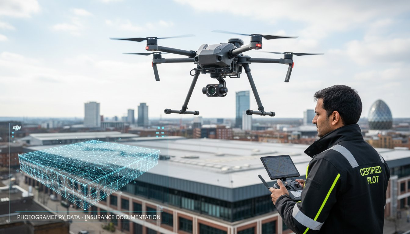
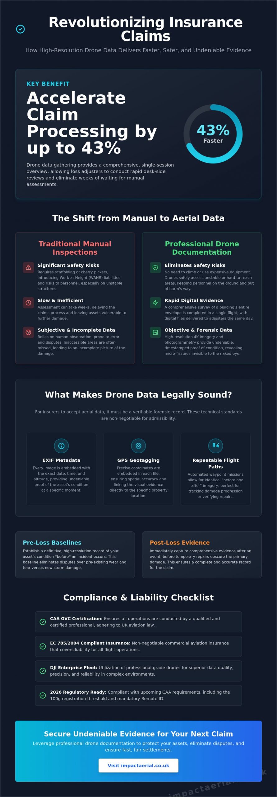
Did you know that utilizing professional drone photography for insurance documentation can accelerate claim processing by 43%? In a sector where time often dictates the scale of a loss, waiting weeks for a manual adjuster to climb a ladder is no longer the industry standard. You’re likely tired of the friction caused by subjective damage assessments and the inherent safety risks of traditional roof inspections. It’s frustrating when a legitimate claim is stalled by disputes over whether a defect is recent storm damage or simple wear and tear.
This guide demonstrates how high-resolution aerial data provides the undeniable evidence needed to secure faster settlements and eliminate inspection risks. We’ll explore the 2026 CAA regulatory requirements, including the new 100g registration threshold and mandatory Remote ID, while detailing how technical photogrammetry turns a visual survey into a forensic record. You’ll learn how to leverage these professional services to ensure every asset condition is documented with total precision, providing added peace of mind for both the insurer and the policyholder.
Key Takeaways
- Discover how high-resolution aerial data streamlines claim processing by up to 43% compared to traditional manual inspection methods.
- Learn the technical standards required for admissibility, including essential EXIF metadata and GPS-referencing for forensic accuracy.
- Understand the strategic value of drone photography for insurance documentation in establishing pre-loss baselines and capturing immediate post-loss evidence.
- Identify why CAA GVC certification and EC 785/2004 compliant insurance are non-negotiable for legally sound data gathering in 2026.
- Explore how utilizing a professional fleet of DJI Enterprise drones provides the precision needed for complex commercial property inspections.
The Shift to Aerial Data: Why Drones are Essential for Insurance in 2026
By May 2026, the insurance industry has largely moved beyond the limitations of manual adjusters. Traditional methods rely on human observation, which is inherently prone to error and often provides incomplete coverage of large or complex structures. We define drone photography for insurance documentation as a forensic data-gathering tool rather than a creative pursuit. This shift ensures that every pixel serves as objective, timestamped proof that stands up to scrutiny during a claim. It turns a subjective argument into a factual discussion.
Utilizing our fleet of DJI Enterprise drones, we capture 4K HDR imagery that reveals breath-taking detail. These high-resolution files allow adjusters to zoom in on micro-fissures in masonry or subtle hairline cracks in roofing tiles that are invisible to the naked eye. This level of precision provides added peace of mind for property owners and stakeholders during the stressful aftermath of an incident. It’s about providing a definitive record that leaves no room for doubt.
To better understand the efficiency of these aerial workflows, watch this helpful video:
Eliminating Safety Risks and Access Issues
Traditional high-level roof inspections require expensive scaffolding or cherry pickers. These methods are slow and introduce significant liability to a site. Drones eliminate these requirements by accessing dangerous or unstable structures post-fire or post-flood without putting personnel at risk. By removing the need for physical climbing, drone technology fundamentally reduces risks associated with the Work at Height Regulations (WAHR). Professional operators must remain compliant with evolving international drone regulations to ensure the resulting data is legally admissible and safety-compliant.
The Speed of Digital Evidence Gathering
Speed is critical when responding to UK weather events, such as the severe wind incidents frequently seen across Birmingham and the West Midlands. A single flight session can capture 100% of a building’s envelope, including hard-to-reach gables and valleys. This comprehensive data set allows for a rapid desk-side review by loss adjusters, often reducing processing times by 43%. Our drone services ensure that evidence is captured before temporary repairs, such as tarpaulin covers, obscure the primary damage. Digital delivery means the entire claim cycle moves faster, from the initial site visit to the final settlement.
Technical Admissibility: What Insurers Require from Drone Imagery
For an insurer to accept aerial data, the files must be more than just clear images; they must be forensic records. High-quality drone photography for insurance documentation relies on embedded EXIF metadata. This data includes the exact date, time, and altitude for every frame captured. Without these verifiable markers, an image is merely a picture without context. In a legal or insurance dispute, these timestamps prove the condition of the asset at a specific moment, preventing claims that damage occurred after the inspection date.
Repeatable flight paths represent another vital technical requirement. By using automated waypoint missions, we can return to the exact same spatial coordinates months or years later. This allows adjusters to compare “before and after” imagery from identical angles and altitudes. This consistency is essential for tracking the progression of structural issues or verifying that repairs were completed to the required standard. While UK operators adhere to CAA standards, those operating in the US must follow FAA Part 107 regulations to ensure their data remains legally sound and admissible in international claims.
Geotagging and Spatial Accuracy
By embedding precise GPS coordinates into every frame, we create an undeniable link between the digital image and the physical location of the asset. This level of spatial accuracy is critical on large commercial sites where identifying a specific roof leak among dozens of identical units is difficult. Our team utilizes DJI Enterprise technology to maintain centimetre-level precision during data collection. This ensures that every defect found is mapped accurately, allowing for seamless integration with existing property management software. If you require this level of forensic detail, our professional drone services provide the technical rigour necessary for complex claims.
Visual Fidelity and Zoom Capabilities
Commercial-grade sensors are non-negotiable for professional evidence gathering. We utilize high-resolution sensors that allow adjusters to identify missing granules on shingles or hairline cracks in masonry from a safe distance. Standard resolution often blurs these fine details, leading to inconclusive reports. High Dynamic Range (HDR) is critical for documenting never-before-seen angles in dark structural recesses, such as under eaves or within charred internal voids. This technology ensures that details in both deep shadows and bright highlights are preserved, providing drone photography for insurance documentation that captures the full extent of the damage without loss of clarity.
Strategic Documentation: Pre-Loss Baselines vs. Post-Loss Claims
Proving the exact moment damage occurred is one of the most difficult challenges in any claim. Without a documented baseline, insurers may attribute structural defects to pre-existing wear and tear rather than a specific event. This is where strategic drone photography for insurance documentation becomes a critical asset for property managers and developers across the UK. By maintaining a chronological record of an asset’s condition, you move from a position of defense to one of undeniable evidence.
Timing is everything. Capturing high-resolution data immediately after a loss event ensures the adjuster sees the raw damage before temporary repairs, such as tarpaulins or emergency boarding, obscure the site. This proactive approach eliminates ambiguity and streamlines the entire settlement process. Understanding the broader context of drone use in the insurance industry reveals that carriers are increasingly favoring policyholders who provide high-quality, professional aerial data over those relying on ground-based snapshots.
The Pre-Loss Baseline Strategy
Establishing a “gold standard” record of your property is the most effective way to mitigate future risk. We recommend conducting annual drone property surveys to create a digital twin of your assets. This digital record serves as a benchmark for long-term structural monitoring, allowing you to track subtle changes in roof health or masonry over time. Proactive documentation often aids in reducing insurance premiums by demonstrating a commitment to meticulous maintenance and risk management. For commercial property developers, this data provides added peace of mind, ensuring that any future claims are backed by a verifiable history of the building’s envelope.
Post-Event Damage Assessment
When a storm hits the West Midlands or other parts of the UK, the damage is rarely uniform. High-velocity winds can cause localized wind uplift, while hail impact might only affect specific elevations. Our drone photography for insurance documentation captures a comprehensive bird’s eye view of the entire site, revealing devastation that is often invisible from the ground. We use advanced photogrammetry to calculate the exact square footage of damaged areas, providing adjusters with precise metrics for material replacement costs. This level of forensic detail prevents disputes over the scale of the loss and ensures your settlement reflects the true cost of restoration. Digital delivery of this data allows for a rapid desk-side review, which is a primary reason why drone-assisted claims are processed 43% faster than traditional manual inspections.
Compliance & Liability: Ensuring Your Drone Data is Legally Sound
Data gathered through drone photography for insurance documentation is only as valuable as its legal admissibility. If an operator fails to meet the stringent UK Civil Aviation Authority (CAA) standards, an insurer has every right to reject the evidence entirely. This is a significant risk when hiring uncertified hobbyists. These individuals often lack the necessary operational authorizations and commercial insurance required to fly in complex environments. In a niche but increasingly diverse market, the distinction between a professional service and a casual flyer is defined by their adherence to the law.
The danger of using uncertified pilots extends beyond simple data rejection. If a drone incident occurs on your site, the lack of professional-grade insurance can leave property managers personally liable for third-party damages. Statistics from 2024 show that 97% of commercial clients now mandate proof of valid insurance and certification before any flight operations begin. Ensuring your pilot is fully vetted is the only way to protect your business interests during a claim.
The Importance of CAA GVC Certification
The General Visual Line of Sight Certificate (GVC) is the professional benchmark in 2026. This certification replaced the older PfCO and ensures that pilots are trained in the latest safety protocols and risk assessments. Certified operators must stay current with the January 1, 2026, regulations, which lowered the registration threshold to 100g and made Remote ID mandatory for all new drones. By working with a pilot who holds a valid UK drone license, you ensure that every flight is logged and conducted within a strict safety framework. This meticulous record-keeping is essential for proving the validity of your data to an insurance adjuster.
Commercial Liability and Professional Indemnity
For added peace of mind, Impact Aerial maintains £5m in commercial liability insurance. This level of coverage is essential when operating high-precision drones on high-value commercial sites or near public infrastructure. Professional operators must carry EC 785/2004 compliant insurance to ensure that all stakeholders are protected. Before commissioning a survey, always ask for a copy of the operator’s insurance certificate and their CAA operator ID. Our affiliations with the Drone Safe Register and ARPAS-UK serve as a non-verbal signature of our commitment to industry standards and reliability.
Data protection is equally vital. Handling high-resolution drone photography for insurance documentation requires strict adherence to GDPR, especially when capturing imagery near third-party properties or public spaces. We ensure that any identifiable data not relevant to the claim is redacted or handled securely. This comprehensive approach to compliance ensures your documentation is both technically superior and legally bulletproof. Contact our CAA GVC Certified team to secure a compliant aerial survey for your next claim.
Impact Aerial: Expert Insurance Documentation in the UK
Impact Aerial operates as a specialized technical consultant within a niche but increasingly diverse market. We recognize that drone photography for insurance documentation requires more than just a pilot; it demands a forensic mindset and a deep understanding of structural data. Our meticulous approach to drone services ensures that property developers, building services, and insurers receive data that is both technically superior and legally sound. From the initial consultation to the final delivery of post-production reports, we manage every detail of the evidence-gathering process.
Our safety-first culture is the foundation of our reputation. We don’t just claim to be safe; we demonstrate it through our CAA GVC Certification and rigorous adherence to the 2026 UK drone regulations. By maintaining a fleet of the latest DJI Enterprise drones, we provide our clients with the reassurance that their assets are being documented by the best technology available. This commitment to precision turns a complex claims process into a manageable, data-driven workflow, providing added peace of mind for all stakeholders involved.
Commercial-Grade Technology
The quality of your evidence depends entirely on the sensors used during the flight. We utilize 4K HDR sensors to capture breath-taking detail, ensuring that even the smallest structural defects are visible in high-contrast environments. For subsurface damage detection, our thermal imaging capabilities reveal heat signatures that indicate moisture ingress or insulation failure behind facades. The precision of our survey drone fleet allows us to generate customized reporting formats. These reports are specifically tailored for the technical requirements of insurance adjusters and structural engineers, featuring GPS-tagged imagery and annotated damage maps that leave no room for misinterpretation.
Your Trusted West Midlands Partner
While we serve the entire UK, our regional expertise in Birmingham and the West Midlands allows us to respond rapidly to local loss events. We understand the specific architectural challenges and weather patterns of the region, from industrial complexes in the Black Country to modern commercial developments in the city centre. This local knowledge, combined with our national reach, makes us a leading partner for comprehensive asset documentation. If you require undeniable evidence for an active claim or wish to establish a pre-loss baseline for your property portfolio, you can Request a Quote through our website. We remain dedicated to providing top-quality results that combine technological innovation with absolute regulatory compliance.
Secure Your Claims with Forensic Aerial Data
The integration of aerial technology into the insurance lifecycle has transformed how we document asset condition. By moving away from manual inspections, you reduce safety risks and capture data that is 43% faster to process than traditional methods. High-resolution drone photography for insurance documentation serves as a forensic record, providing the undeniable evidence needed to settle disputes over wear and tear. It’s no longer just about taking photos; it’s about gathering objective data that stands up to scrutiny.
Maintaining compliance with the latest 2026 CAA regulations ensures your data remains legally sound and admissible. Professional operators provide the technical rigour that hobbyists can’t match, particularly when handling complex commercial property surveys. Our team combines regional expertise in the West Midlands with a national reach, ensuring every flight is backed by meticulous risk assessments. Secure your property’s evidence, contact Impact Aerial for a professional insurance documentation quote today. With our CAA GVC Certified pilots, £5m commercial liability insurance, and a fleet of DJI Enterprise 4K HDR drones, we provide the precision you need for total peace of mind. You can trust our experts to protect your interests through every stage of the claim.
Frequently Asked Questions
Is drone photography admissible in UK insurance claims?
Yes, drone photography for insurance documentation is fully admissible in the UK provided it is captured by a CAA GVC Certified pilot. For the data to be legally sound, it must include forensic EXIF metadata such as date, time, and precise GPS coordinates. 2024 industry data indicates that this objective evidence helps process claims 43% faster than traditional manual methods by removing subjective disputes.
How much does a drone survey for insurance cost in the UK?
In 2026, drone roof inspections for insurance claims typically cost between $0.15 and $0.45 per square foot. This is significantly more cost-effective than manual inspections, which can range from $0.75 to $1.25 per square foot due to scaffolding and labour requirements. Adding thermal imaging capabilities for subsurface damage detection generally adds between $0.08 and $0.15 per square foot to the total survey cost.
What certifications should a drone pilot have for insurance work?
A professional pilot must hold a General Visual Line of Sight Certificate (GVC) and a valid CAA Operator ID, which carries an annual fee of £12.34 as of May 2026. They must also ensure compliance with the 100g registration threshold that took effect on January 1, 2026. These credentials prove the operator is trained in the latest safety protocols and understands mandatory Remote ID broadcast requirements.
Can drones detect internal water damage or just external roof issues?
Drones equipped with thermal sensors can detect subsurface moisture and internal water ingress by identifying temperature anomalies in the building envelope. While standard 4K HDR sensors are perfect for external issues like hairline cracks or slipped tiles, thermal data enhances underwriting accuracy by 40% to 60%. This allows adjusters to see trapped moisture that hasn’t yet manifested as visible internal staining.
Do I need to inform my neighbors if a drone is documenting my building?
You aren’t strictly required by law to obtain neighbor consent for a legal flight, but you must comply with GDPR and privacy regulations regarding data storage. Professional operators use meticulous flight paths to ensure third-party properties aren’t the focus of the drone photography for insurance documentation. Since January 1, 2026, all new drones utilize Remote ID, which provides public transparency regarding the drone’s identity and position.
How long does it take to receive the drone documentation report?
Most digital documentation reports are delivered within 24 to 72 hours following the flight session. This rapid turnaround is essential for responding to storm events in the West Midlands where evidence must be captured before temporary repairs begin. The speed of digital delivery is the primary reason why drone-assisted claims move through the settlement cycle 43% faster than those relying on ground-based adjusters.
What happens if a drone crashes during an insurance inspection?
Professional operators carry EC 785/2004 compliant insurance to handle any incidents, providing total protection for the property owner. Impact Aerial maintains £5m in commercial liability insurance for added peace of mind on high-value sites. A 2025 report showed that one in seven commercial drone incidents lead to third-party claims, making professional-grade insurance a non-negotiable requirement for any commercial contract.
Can drones be used for pre-loss risk assessments to lower premiums?
Yes, establishing a “gold standard” pre-loss baseline can enhance underwriting accuracy by up to 60%. By providing insurers with high-resolution evidence of a well-maintained roof or structure, property owners can often negotiate more favourable premiums. This proactive documentation eliminates disputes over pre-existing wear and tear, ensuring that any future claim settlements are based on the actual damage sustained during a specific event.
