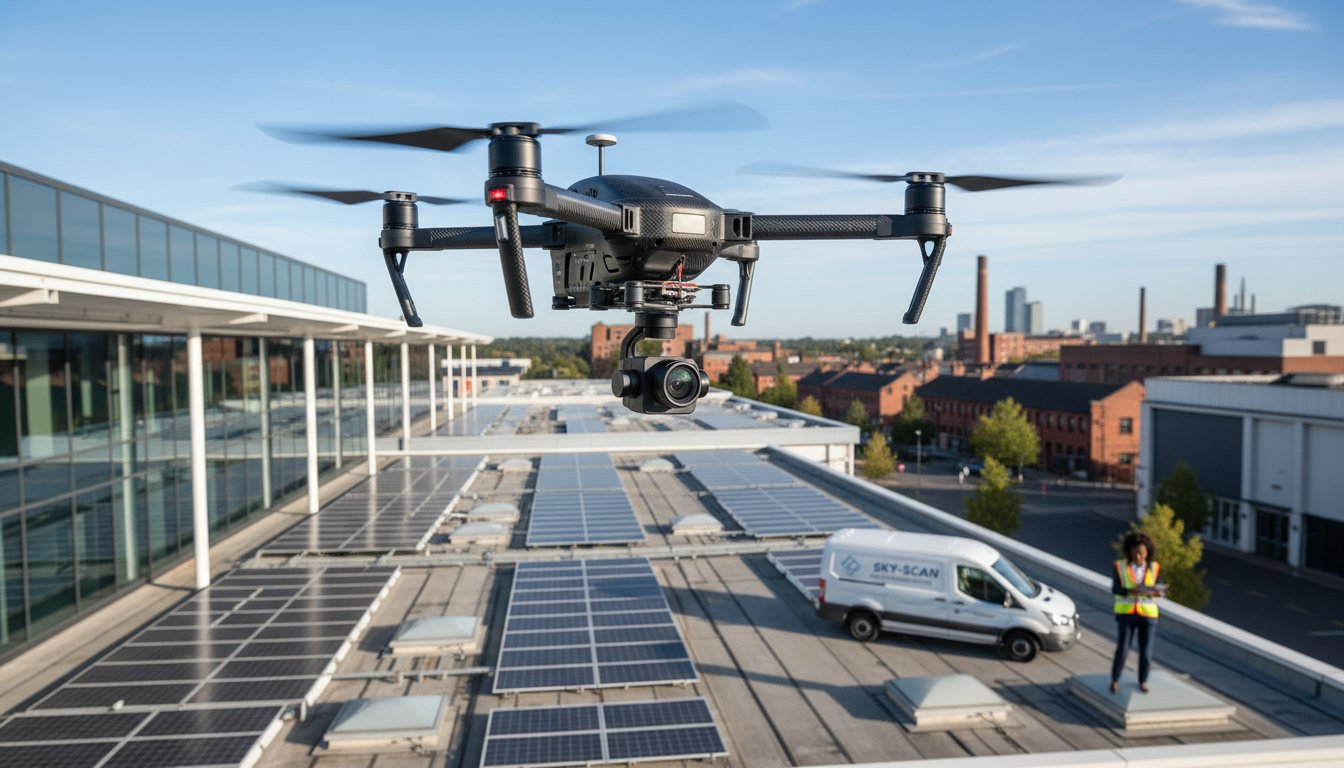
For property managers and building owners, the prospect of a roof inspection often brings to mind the high costs of scaffolding, significant operational downtime, and the unavoidable safety risks of working at height. This traditional approach, however, is no longer the only option. A professional drone roof survey offers a modern, efficient alternative, transforming how we assess and maintain building envelopes without the need for costly access equipment or putting personnel in hazardous situations.
This comprehensive guide will explore how this innovative technology provides a safer, faster, and remarkably more cost-effective solution for your property. We will detail how our CAA GVC certified pilots utilise high-resolution imaging and advanced data-gathering techniques to deliver a level of detail that is simply unattainable from the ground. You will discover how a drone-based inspection minimises disruption, eliminates physical risks, and provides you with a clear, actionable report to make informed maintenance decisions with complete peace of mind.
What is a Drone Roof Survey? The Modern Alternative to Scaffolding
A drone roof survey is a professional inspection service that utilises a commercial-grade unmanned aerial vehicle (UAV), equipped with high-resolution cameras, to conduct a thorough aerial assessment of a roof’s condition. This modern data-gathering technique replaces traditional methods that often involve expensive scaffolding, hazardous ladders, or access platforms like cherry pickers. Instead of putting personnel at risk, a certified pilot can safely and systematically capture detailed imagery from multiple angles, providing a complete and accurate picture of the roof structure.
To see how this process works in practice, this short video provides an excellent overview of a typical drone inspection flight plan:
The core deliverable of a professional drone roof survey is a comprehensive report. This document contains detailed, high-resolution photographs and video footage, with any defects, potential issues, or areas of concern clearly annotated. This approach offers several key advantages over manual inspections:
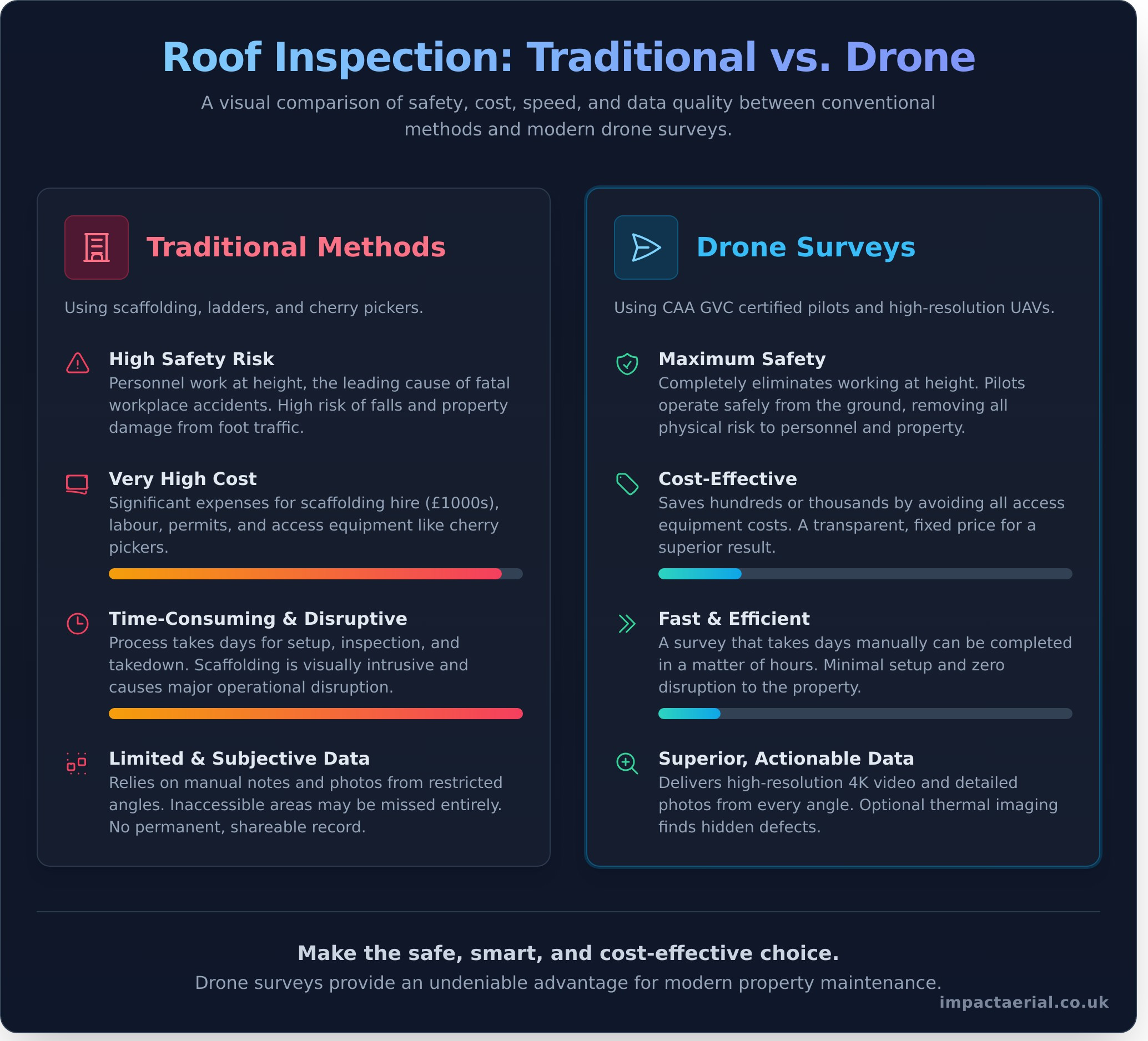
- Enhanced Safety: It completely eliminates the need for working at height, mitigating the most significant risk associated with traditional roof inspections.
- Speed and Efficiency: A survey that might take days to complete with scaffolding can often be finished in a matter of hours, minimising disruption to the property.
- Cost-Effectiveness: By avoiding the significant costs of scaffolding hire and labour, a drone survey can save clients hundreds, if not thousands, of pounds.
- Superior Data Quality: The high-resolution data captured provides an unambiguous and permanent record of the roof’s condition, which can be easily shared with contractors, surveyors, or insurers.
Who Needs a Drone Roof Survey?
This professional service is invaluable for a wide range of clients who require accurate and timely roof condition data. Key stakeholders include:
- Property and Facilities Managers for scheduled maintenance programmes and creating condition reports for large commercial portfolios.
- Building Surveyors and Chartered Surveyors conducting due diligence, dilapidation reports, or structural assessments.
- Homeowners seeking a fast, safe assessment after storm damage or before finalising a property purchase.
- Construction Companies for monitoring project progress on new builds and creating snagging lists without disrupting site work.
The Technology Behind the Survey
Our professional services are powered by leading-edge technology to ensure the highest quality results. We operate commercial-grade DJI Enterprise drones, renowned for their stability and reliability. The key components of our survey equipment include:
- High-Resolution 4K Cameras that capture crystal-clear visual data, allowing us to zoom in on potential defects like cracked tiles or failing flashing.
- Optional Thermal Imaging Cameras to detect hidden issues such as water ingress, moisture build-up, or areas of significant heat loss not visible to the naked eye.
- GPS and Automated Flight Planning Software which enables us to perform systematic, grid-based flights for complete and comprehensive coverage of the entire roof area.
Safety First: Eliminating the Dangers of Working at Height
Traditional roof inspections are inherently dangerous. According to the Health and Safety Executive (HSE), falls from height remain the leading cause of fatal accidents for UK workers. Every time an inspector climbs a ladder or steps onto scaffolding, they face significant risks, from slips and falls to the structural instability of the roof itself. A professional drone roof survey fundamentally changes this dynamic by removing the human element from the point of risk. Our operators remain safely on the ground, eliminating the potential for life-altering accidents.
This modern approach not only protects personnel but also safeguards the property. Fragile materials like slate, clay tiles, or aged asbestos sheeting can be easily damaged by foot traffic, leading to costly secondary repairs. Drones capture high-resolution data without ever making physical contact, preserving the integrity of your asset.
Traditional Method Risks vs. Drone Safety
The logistical and financial burdens of conventional access methods are significant. Drones offer a superior alternative by sidestepping these common challenges:
- Scaffolding: Erecting scaffolding is expensive, time-consuming, and visually intrusive, often requiring permits and disrupting daily operations. In contrast, a drone survey is swift and discreet, providing a clear cost-effectiveness and financial advantage with minimal setup.
- Ladders: While quick to deploy, ladders are notoriously unstable, offer limited reach, and place the inspector in a precarious position, restricting their ability to conduct a thorough examination.
- Cherry Pickers (MEWPs): These require stable, level ground and clear access, making them unsuitable for many sites. They are also costly to hire and operate.
The Role of Professional Certification and Insurance
The safety of a drone roof survey is underpinned by rigorous professional standards. Hiring a pilot with a Civil Aviation Authority (CAA) General Visual Line of Sight Certificate (GVC) is non-negotiable for any commercial operation in the UK. This certification proves the operator is trained in safe flight procedures, risk mitigation, and aviation law. For added peace of mind, we carry comprehensive commercial liability insurance up to £5 million. Every mission begins with a detailed pre-flight risk assessment and operational plan, ensuring all potential hazards are identified and managed. Our certified pilots ensure every survey is safe and compliant. Learn about our process.
Unmatched Speed & Minimal Disruption
In property management and maintenance, time is a critical resource. Traditional methods of roof inspection, such as erecting scaffolding, can take days or even weeks to arrange and construct, causing significant operational delays and disruption. This process often involves cordoning off large areas, creating noise, and inconveniencing tenants or customers, all before a single tile has been inspected.
A professional drone roof survey fundamentally changes this dynamic. The entire on-site data capture is typically completed in just one to two hours, even for large or complex commercial buildings. There is no need for heavy equipment, road closures, or restricted access. Our CAA GVC certified pilots operate efficiently and discreetly, ensuring your business operations continue uninterrupted. This efficiency extends to data delivery, with initial high-resolution findings often available on the same day for urgent assessments.
The Drone Survey Process: From Enquiry to Report
Our process is designed for maximum efficiency and clarity, providing you with actionable data swiftly. Each step is handled with meticulous attention to detail to ensure safety and quality.
- Step 1: Initial Consultation: We discuss your specific requirements and conduct a preliminary desktop assessment of the site to identify any potential airspace restrictions or hazards.
- Step 2: On-Site Assessment & Flight: Our pilot arrives on site, conducts a thorough risk assessment, establishes a safe flight zone, and executes the pre-planned flight path.
- Step 3: Comprehensive Data Capture: The drone captures high-resolution imagery and video of the entire roof structure, including gutters, chimneys, and flashing, from multiple angles to ensure no detail is missed.
- Step 4: Processing & Reporting: The captured data is processed to create a detailed digital report, complete with annotated images and expert observations, delivered to you securely online.
How Drones Accelerate Project Timelines
The speed of a drone roof survey creates a powerful ripple effect across your entire project or maintenance workflow. By providing clear, comprehensive data almost immediately, you can accelerate crucial next steps. Roofers can provide more accurate quotes faster without needing a site visit, and insurance claims can be processed more quickly with indisputable photographic evidence of damage. This rapid insight also enables a proactive maintenance schedule, allowing for more frequent, cost-effective inspections to identify minor issues before they escalate into expensive structural problems.
Cost-Effectiveness: A Clear Financial Advantage
When evaluating the options for inspecting a roof, the financial implications are a primary consideration. A professional drone roof survey presents a compelling case not just for its technological superiority, but for its significant cost savings over traditional methods. This modern approach eliminates many of the substantial, and often hidden, costs associated with manual, at-height inspections, delivering a higher return on investment.
Breaking Down the Costs of Traditional Surveys
Manual roof inspections rely on expensive access equipment, with costs that quickly accumulate and often lack transparency. Consider the typical expenses in the UK:
- Scaffolding Hire: A standard setup for a semi-detached house can easily cost between £900 and £1,500, factoring in erection, weekly hire, and dismantling fees.
- Cherry Picker (MEWP) Rental: This option involves hourly rates (typically £75-£150 per hour), in addition to delivery charges and the cost of a certified operator.
- Associated Costs: These methods may also require costly permits from local councils for pavement or road closures, adding another layer of expense and administration.
What’s Included in a Drone Roof Survey Cost?
In stark contrast, a drone survey is typically offered at a fixed, all-inclusive price, providing complete cost certainty from the outset. For a clear, one-off fee, our professional service includes the deployment of a fully insured, CAA GVC Certified pilot, the use of professional-grade drone and camera systems, and the subsequent data processing to create a detailed, actionable PDF report. This transparent model ensures there are no surprise charges.
Indirect Savings and Added Value
The financial benefits extend far beyond the initial quote. The true value lies in the long-term ROI and operational advantages. Early detection of minor issues-such as a cracked tile or failing flashing identified in high-resolution detail-can prevent them from escalating into major structural repairs costing thousands of pounds. For commercial properties, the minimal disruption means business can continue as usual, avoiding costly downtime. You also receive a permanent digital record of your roof’s condition, providing invaluable evidence for insurance claims and a stronger negotiating position with contractors. For a detailed, fixed-price quotation for your property, contact our team.
Superior Data: See Your Roof in Unprecedented Detail
A key advantage of a professional drone roof survey is the sheer quality and comprehensiveness of the data collected. Where a ground-based inspection is limited by perspective and access, our advanced drones capture a complete, high-resolution digital record of your entire roof structure. This allows for the meticulous inspection of every component, including hard-to-reach areas like complex roof valleys, chimney stacks, and high-level guttering, without the risks associated with working at height.
The result is not just a set of photographs, but a complete visual archive of your asset’s condition at a specific point in time. This data is invaluable for future reference, allowing for direct comparison to identify degradation over time. Our deliverables extend beyond raw imagery to include detailed, annotated reports and high-definition videos that clearly communicate our findings.
Visual Inspections with 4K High-Resolution Imagery
Our drones are equipped with commercial-grade 4K cameras and powerful zoom capabilities. This technology allows us to identify even minor defects with exceptional clarity, such as cracked tiles, loose flashing, damaged mortar, or blockages in guttering. We can also perform orthomosaic mapping, a process where hundreds of individual photos are digitally stitched together to create a single, high-resolution, top-down image of your roof. This provides clear, irrefutable evidence of any issues for inclusion in maintenance reports or quotes from contractors.
Advanced Data: Thermal Imaging and 3D Models
For a deeper diagnostic insight, we offer advanced data-gathering services. A thermal drone roof survey uses infrared sensors to detect temperature variations across the roof surface, identifying problems invisible to the naked eye. This is highly effective for locating hidden water ingress, pinpointing areas of trapped moisture beneath the roof membrane, and highlighting insulation gaps that lead to significant energy loss. Furthermore, using a technique called photogrammetry, we can generate a dimensionally accurate 3D model of your property for precise measurements and planning. Need more than just photos? Ask about our advanced data services.
Make the Smart Choice for Your Property’s Roof Inspection
The days of relying on costly, disruptive scaffolding and accepting the inherent risks of working at height are over. As we’ve detailed, aerial inspections offer a modern, superior alternative by delivering unmatched safety, remarkable speed, and significant cost savings. Choosing a professional drone roof survey is a direct investment in operational efficiency and the acquisition of high-resolution visual and thermal data that traditional methods simply cannot replicate.
At Impact Aerial, we provide this leading service for the property and construction sectors across the UK. For your complete peace of mind, all our operations are conducted by CAA GVC Certified and Fully Insured pilots. We utilise advanced 4K and thermal data capture technology to identify potential issues with pinpoint accuracy, delivering the detailed, actionable insights you need to make critical decisions about your assets.
Ready to see the difference for yourself? Get a fast, no-obligation quote for your professional drone roof survey. Take the first step towards a smarter, safer inspection for your property today.
Frequently Asked Questions About Drone Roof Surveys
How much does a drone roof survey cost in the UK?
The cost of a drone roof survey in the UK typically starts from around £250 for a small residential property and can increase to £1,000 or more for large or complex commercial buildings. The final price is influenced by factors such as the roof’s size, the complexity of the structure, and the level of detail required in the final report. For an accurate, no-obligation quotation, we recommend contacting us directly to discuss your specific requirements.
Are drone roof surveys accurate and reliable?
Yes, when conducted by a qualified professional, drone surveys are exceptionally accurate. Our commercial-grade drones are equipped with high-resolution 4K cameras and optional thermal imaging sensors, capturing precise data that is often superior to traditional methods. This technology allows for the clear identification of subtle defects, water ingress, or heat loss that might be missed from ground level, providing a comprehensive and verifiable record of the roof’s condition.
What kind of report do I receive after a drone roof survey?
Following the survey, you will receive a comprehensive digital report package. This includes a portfolio of high-resolution still images, 4K video footage, and a detailed PDF document. The written report highlights key findings, with images annotated to pinpoint specific areas of concern such as damaged tiles, blocked gutters, or potential leaks. This provides you with clear, actionable data to inform maintenance decisions and share with roofing contractors or insurers.
Do I need to be present during the drone survey?
It is not a requirement for you to be present for the duration of the survey. Our CAA GVC Certified pilot will manage the entire operation safely and efficiently, following a pre-agreed flight plan and a thorough risk assessment. You are welcome to be on-site if you wish, but you can have complete peace of mind knowing the data-gathering process is in expert hands. All findings will be delivered to you in the comprehensive post-flight report.
Is a drone survey possible in bad weather like wind or rain?
For safety and data quality, a professional drone roof survey cannot be conducted in adverse weather conditions like rain or high winds. Rain can damage sensitive equipment and obscure the camera lens, while high winds affect the drone’s stability and safety. As a responsible, CAA-regulated operator, we always operate within strict safety parameters and will reschedule the survey for the next suitable day to ensure top-quality, reliable results are achieved.
How do I know if the drone company is properly licensed and insured?
A professional UK drone operator must hold a valid Operational Authorisation from the Civil Aviation Authority (CAA). You should always ask to see proof of this and their commercial liability insurance certificate, which must cover aviation risks. For added peace of mind, reputable operators are often members of professional bodies like the Drone Safe Register, which further validates their credentials and commitment to safe, legal operations.
