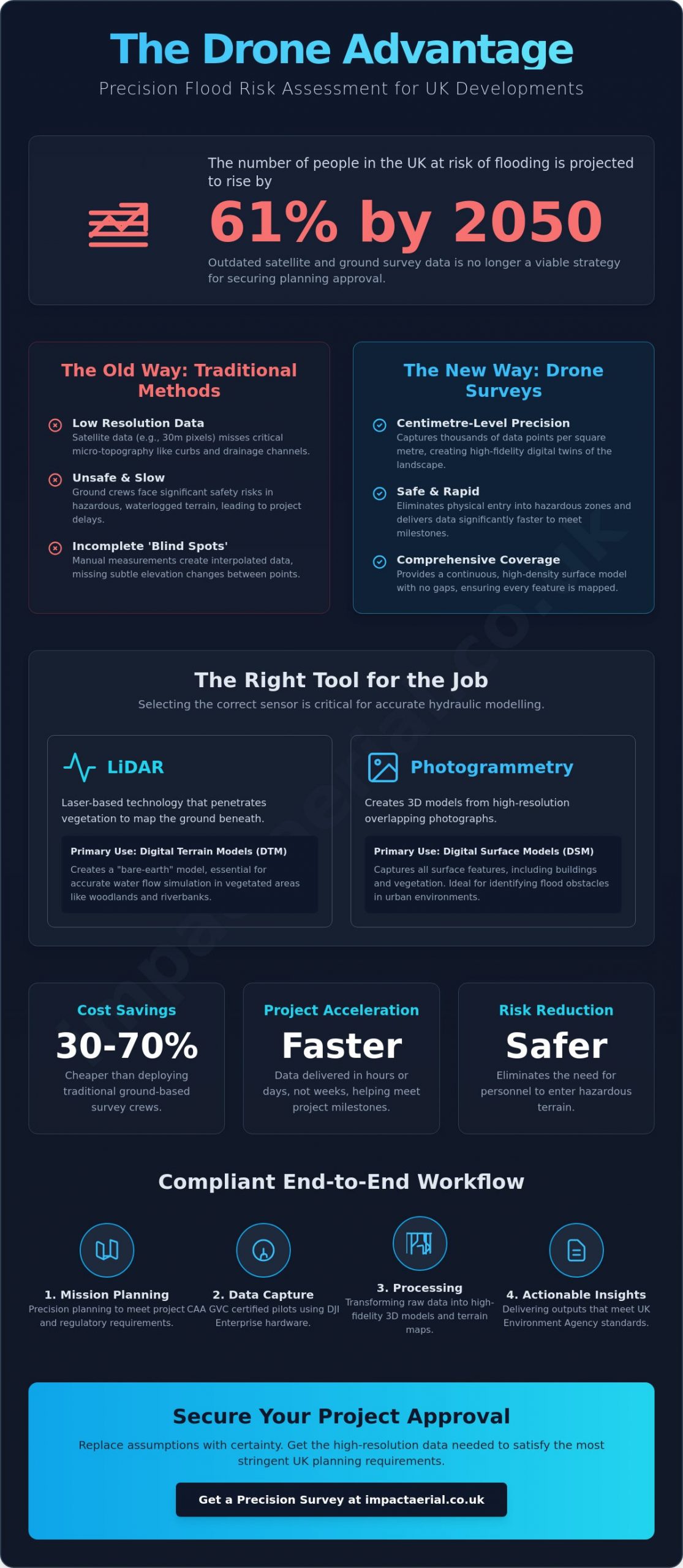
With the number of people in the UK at risk of flooding projected to rise by 61% by 2050, relying on outdated satellite imagery or coarse topographical data is no longer a viable strategy for developers. You’ve likely felt the frustration of a rejected planning application because a hydraulic model lacked the necessary granularity. A professional drone survey for flood risk assessment bridges this gap, replacing low-resolution assumptions with centimetre-level precision that satisfies the most stringent UK planning requirements.
We understand that sending ground crews into hazardous, waterlogged terrain is both a safety liability and a significant drain on project budgets. It’s clear that traditional methods often fail to capture the subtle elevation changes that dictate water flow. This guide demonstrates how high-resolution drone data transforms flood risk modelling by providing the high-fidelity terrain maps needed for infrastructure safety. We will explore the latest 2026 UK CAA regulations, the critical differences between LiDAR and photogrammetry, and how these digital twins accelerate project approval timelines while drastically reducing operational risk.
Key Takeaways
- Understand why centimetre-accurate topographic data is essential for securing UK planning approval and overcoming the resolution limits of traditional satellite imagery.
- Identify when to deploy LiDAR technology to penetrate dense woodland canopies and generate the high-fidelity Digital Terrain Models required for complex hydraulic modelling.
- Learn how to mitigate legal and operational risks by ensuring your drone survey for flood risk assessment is conducted by CAA-qualified pilots holding current GVC certification.
- Explore the end-to-end survey workflow, from precision mission planning to the delivery of professional outputs using DJI Enterprise-grade hardware.
- Recognise how aerial surveys can be 30-70% cheaper than traditional ground-based methods while delivering data significantly faster to meet project milestones.
Why Traditional Flood Risk Assessments Need an Aerial Upgrade
A drone survey for flood risk assessment represents a fundamental shift from static, low-resolution mapping to dynamic, high-density topographic data acquisition. In 2026, as the UK faces an increasingly volatile climate, the demand for high-fidelity data has never been higher. Traditional methods often rely on interpolated data points that miss critical micro-topographic features. By capturing thousands of data points per square metre from an aerial perspective, we provide a digital twin of the landscape that accurately predicts water movement during surge events.
While satellite imagery provides a broad overview, it frequently fails in dense UK urban environments. Buildings, narrow alleyways, and complex infrastructure create “shadows” and resolution limits that render satellite data insufficient for site-specific planning applications. A 30m pixel simply cannot capture the guttering or the slight curb elevation that determines whether a property floods or stays dry. High-resolution aerial data fills these gaps, providing the precision required for modern hydraulic models.
To better understand how this technology integrates with disaster mitigation, watch this helpful video:
Ground surveys, while accurate at specific points, carry inherent “blind spots” when applied to large-scale developments. Sending a crew into marshes or steep riverbanks is not just slow; it’s a significant safety risk that can delay project milestones. Aerial data eliminates these hazards, providing a continuous surface model without the gaps associated with manual rod-and-level measurements. This ensures that no dip or drainage channel is overlooked in the final assessment.
The Limitations of Satellite and Ground Surveys
Standard satellite data often operates at a resolution where a single pixel covers a large area, masking the subtle dips in terrain that lead to pooling. For professional flood modelling, this lack of granularity is a liability. Through unmanned aerial photogrammetry, we generate 3D models with centimetre-level accuracy. This precision allows developers to map hazardous floodplains and dense urban zones safely, reducing the logistical footprint and overall cost compared to traditional ground teams.
Meeting UK Environment Agency Standards
Compliance is the cornerstone of any successful development project. Our data is structured to align with national flood risk mapping requirements, ensuring that your hydraulic models are built on a solid foundation. High-resolution drone outputs are particularly vital when applying for Flood Risk Activity Permits, where the Environment Agency demands rigorous proof of terrain elevation. For projects across the West Midlands, we provide local planning authorities (LPAs) with defensible, high-tier data that withstands scrutiny and helps accelerate the approval process.
The Technical Edge: LiDAR vs. Photogrammetry for Flood Modelling
Selecting the correct sensor technology is the most critical decision in any drone survey for flood risk assessment. Engineers and planners must distinguish between Digital Surface Models (DSM), which capture every object on the landscape, and Digital Elevation Models (DEM), which represent the bare earth. While a DSM is useful for identifying obstacles like flood defences, a DEM is essential for accurate hydraulic modelling. Without an accurate DEM, water flow simulations will be skewed by vegetation and man-made structures, leading to potentially dangerous inaccuracies in risk predictions.
In 2026, the industry has moved beyond simple 2D mapping. We now create high-fidelity ‘Digital Twins’ of floodplains. These 3D replicas allow for predictive hydraulic simulations that test various ‘what-if’ scenarios, such as the impact of a 1-in-100-year storm event. By combining different data layers, we provide a comprehensive view of how water interacts with both the natural terrain and the built environment. This technical depth is what separates professional surveys from amateur aerial photography.
LiDAR: The Gold Standard for Topography
LiDAR (Light Detection and Ranging) remains the gold standard for mapping the UK’s complex riverbanks and wooded floodplains. By emitting thousands of laser pulses per second, LiDAR can penetrate dense canopy cover to reach the ‘true ground’ beneath. This capability is vital for achieving the sub-5cm vertical accuracy required for professional water flow analysis. Our pilots utilise advanced survey drone technology equipped with RTK (Real-Time Kinematic) positioning to ensure these datasets are georeferenced and ready for immediate integration into CAD or GIS software. For sites with heavy vegetation, LiDAR is the only way to ensure your flood model isn’t based on the height of the bushes rather than the height of the soil.
Photogrammetry and Multispectral Imaging
Photogrammetry offers a cost-effective alternative for urban environments where vegetation is minimal. By stitching thousands of 4K HDR images into a georeferenced orthomosaic, we provide high-resolution visual context that LiDAR cannot match. This visual clarity helps identify soil moisture levels and existing drainage patterns that are invisible from the ground. Recent academic research on drone water level detection highlights how multispectral and thermal imaging can even detect hidden saturation points in infrastructure before they become critical failures. If you’re managing a large-scale development, our drone commercial property surveys provide the precise data foundation needed for long-term flood resilience and infrastructure safety.
Thermal imaging adds another layer of safety by identifying water leaks or points of structural weakness in levees and dams. These thermal signatures reveal where water is permeating through barriers, allowing for proactive maintenance. By integrating these multispectral layers into the final survey, we offer more than just a map; we deliver a complete diagnostic tool for flood risk management.
Ensuring Compliance: UK Drone Laws and Safety in Flood Zone Surveys
Compliance is not merely a box-ticking exercise; it is a critical safeguard for your business and the integrity of your data. Hiring an amateur pilot for a drone survey for flood risk assessment introduces significant legal liabilities that can jeopardize an entire development project. In the UK, commercial drone operations are strictly governed to ensure public safety and data accuracy. If a surveyor lacks the correct certifications, the resulting data may be deemed inadmissible by local planning authorities or the Environment Agency, leading to costly delays and potential fines.
Risk management is particularly complex in urban environments like Birmingham and across the West Midlands, where floodplains often intersect with high-density housing and critical infrastructure. Operating in these areas requires a meticulous approach to safety. Professional operators must hold a minimum of £5 million in commercial third-party liability insurance. This level of coverage is the industry standard for professional service providers, offering reassurance that all stakeholders are protected during complex data acquisition missions in challenging terrain.
The Regulatory Framework in 2026
Navigating the legal landscape requires a deep understanding of current aviation standards. In 2026, any professional conducting commercial work must stay current with the latest UK drone license requirements. This includes holding a General Visual Line of Sight Certificate (GVC), which is essential for operating in the Specific Category. This qualification allows pilots to fly closer to people and property than the standard Open Category rules permit, which is often necessary when surveying flood-prone urban zones. All missions are conducted in strict adherence to the UK Civil Aviation Authority Drone Code, ensuring that every flight is both legal and safe.
Operating near sensitive UK infrastructure, such as railway lines or power stations, often involves flying within ‘Restricted’ or ‘Controlled’ airspace. A professional operator handles the complex task of securing the necessary permissions from Air Traffic Control (ATC) and other relevant bodies. This meticulous preparation ensures that the drone survey for flood risk assessment proceeds without infringing on national security or aviation safety protocols.
Risk Mitigation and Public Safety
Our commitment to safety begins long before the drone leaves the ground. We conduct a comprehensive Pre-Flight Site Assessment (PFSA) for every mission. This process identifies potential hazards such as overhead power lines, tall structures, and public footpaths. In residential flood zones, we also manage privacy concerns by ensuring our flight paths and data capture techniques respect the privacy of local residents while still gathering the high-fidelity topographic data required for the project.
The Impact Aerial approach is built on a foundation of reliability and technical competence. We use a structured, methodical workflow to ensure that every mission is executed with precision. By combining safety-conscious data collection with advanced DJI Enterprise-grade hardware, we deliver centimetre-accurate results that you can trust. This meticulousness provides our clients with the psychological comfort that their project is in expert hands, fully compliant with all 2026 UK aviation regulations.
From Raw Data to Actionable Insights: The Survey Workflow
The execution of a professional drone survey for flood risk assessment follows a structured, four-phase lifecycle. This methodical approach ensures that every project meets the high standards required by UK engineering firms and local authorities. We begin with a comprehensive initial consultation to align mission planning with your specific flood mitigation objectives. This ensures that the data we capture provides the necessary evidence for planning compliance and infrastructure safety.
Phase two focuses on high-precision data acquisition. Our pilots deploy DJI Enterprise-grade hardware to ensure the highest tier of data quality and reliability. Following the flight, phase three involves technical data processing. We transform raw point clouds into detailed 3D models that accurately reflect the site’s topography. The final phase is the integration of these datasets into professional hydraulic modelling software, such as HEC-RAS or TuFLOW. This workflow allows for the creation of predictive simulations that are far superior to those built on traditional data sources.
High-Resolution Data Acquisition
During the acquisition phase, we capture 4K HDR imagery to provide a clear visual record of existing flood defences and drainage infrastructure. Absolute accuracy is non-negotiable in flood modelling. We use strategically placed Ground Control Points (GCPs) to tie the aerial data to the national grid with centimetre-level precision. Our flight teams maintain real-time monitoring of site conditions and hardware telemetry throughout the mission. This meticulous attention to detail ensures that all data is captured safely and efficiently, even in the complex environments of the West Midlands.
Post-Production and Technical Reporting
The post-production phase is where raw data becomes a valuable asset for your engineering team. We deliver georeferenced TIFFs, LAS point clouds, and high-density 3D meshes that are ready for immediate technical analysis. Our drone survey results provide the defensible evidence needed to inform critical design and safety decisions. For projects requiring stakeholder engagement or public consultation, we also offer immersive virtual tour creation. These interactive models allow planners and the public to explore the site virtually, fostering better understanding and faster project approvals. Contact us today to discuss how our construction site monitoring and survey services can secure your project’s data requirements.
Choosing Impact Aerial for Your Flood Risk Assessment
Selecting a partner for a drone survey for flood risk assessment requires a balance of technical capability and regulatory rigour. Based in Birmingham, we leverage our central location to provide rapid, UK-wide deployments for infrastructure projects and large-scale developments. Our commitment to using the latest DJI Enterprise technology ensures that every data point we collect meets the centimetre-level accuracy standards demanded by modern hydraulic engineering. We provide a seamless, full-service approach that manages everything from initial mission planning to final post-production, saving our clients significant time and administrative overhead.
By handling the entire data lifecycle in-house, we eliminate the communication gaps that often occur when outsourcing processing to third parties. This integrated workflow ensures that the final Digital Terrain Models (DTM) and orthomosaics are perfectly aligned with your project’s technical specifications. Our focus on precision and reliability provides the psychological comfort that your flood modelling is based on the highest tier of available data, fully compliant with 2026 UK standards.
Expertise in the Property and Construction Sectors
Our team has extensive experience supporting the property and construction industries with high-tier data. We have successfully delivered professional drone services for diverse projects, including complex topographic mapping for new housing estates and flood defence inspections. Beyond technical data, our aerial filming drone capabilities provide the cinematic clarity needed for comprehensive visual documentation and stakeholder presentations. You have direct access to our CAA GVC certified pilots for technical consultation, ensuring that your project is grounded in both aviation law and engineering reality.
Next Steps: Securing Your Site with Aerial Data
The process begins with a structured consultation where we define your specific data requirements and accuracy thresholds. Whether you need a Digital Terrain Model for a planning application or a thermal survey to detect saturation points in existing defences, we tailor our flight parameters to your objectives. We also maintain rapid deployment capabilities for emergency situations where immediate flood assessments are required to protect critical assets. Reliability is the core of our business; we don’t just fly drones, we provide the precision data that secures your project’s future. Contact Impact Aerial today for a professional flood risk survey quote.
Securing Future Developments with Precision Aerial Data
The transition toward high-fidelity digital twins is no longer optional for UK developers. We’ve explored how LiDAR and photogrammetry provide the bare-earth accuracy that satellite data simply cannot match. By commissioning a professional drone survey for flood risk assessment, you ensure your hydraulic models are built on a foundation of centimetre-level precision. This technical rigour is essential for meeting Environment Agency standards and securing local planning approvals in an increasingly volatile climate. It’s about replacing uncertainty with actionable, high-density topographic data that protects both your investment and the community.
Safety and compliance remain our highest priorities. Our operations are led by CAA GVC Certified Pilots and backed by £5m Commercial Liability Insurance. We utilize DJI Enterprise Grade Hardware to deliver the defensible data your engineering team requires. Whether you are managing a large-scale construction site or conducting commercial property surveys, we provide the expert oversight needed to mitigate operational risk. We look forward to helping you safeguard your next project with the UK’s leading aerial data solutions.
Request Your Professional Drone Survey Quote Today
Frequently Asked Questions
Are drone surveys for flood risk assessment legally required in the UK?
There is no standalone law mandating drones for flood mapping, but they are often a practical requirement to satisfy Environment Agency evidentiary standards. Local Planning Authorities (LPAs) frequently demand high-resolution topographic data to validate hydraulic models before granting planning permission for developments in high-risk zones. A drone survey for flood risk assessment provides the defensible data necessary to meet these rigorous UK planning requirements.
How much more accurate is a drone survey compared to satellite data?
Drone surveys provide centimetre-level accuracy that far exceeds the capabilities of standard satellite imagery. While satellites often operate at resolutions of 10m to 30m per pixel, drone-mounted LiDAR or photogrammetry sensors achieve horizontal accuracy of ±2-3 cm and vertical accuracy of ±2-5 cm. This level of detail is essential for identifying micro-topographic features, such as slight curb elevations, that dictate water movement in urban environments.
Can drones perform flood surveys in heavy rain or high winds?
Professional drone operations are restricted by weather conditions to protect data integrity and ensure aviation safety. Most enterprise-grade hardware is grounded if sustained winds or gusts exceed 20-25 mph or during periods of heavy precipitation. Rain interferes with LiDAR laser pulses and reduces the clarity of photogrammetry imagery, so we meticulously schedule missions during optimal weather windows to guarantee the highest tier of precision.
What type of data formats do you provide for hydraulic modelling?
We deliver data in various industry-standard formats that are fully compatible with software like HEC-RAS, TuFLOW, and AutoCAD. Common deliverables include LAS or LAZ point clouds for LiDAR datasets, georeferenced orthomosaic TIFFs, and Digital Terrain Models (DTM) in CSV or DXF formats. These outputs allow your engineering team to integrate our aerial data directly into their predictive simulation workflows without additional conversion delays.
How long does it take to complete a drone survey for a 50-acre site?
The data acquisition phase for a 50-acre site typically takes between two to four hours on-site, depending on the terrain’s complexity and vegetation density. Following the flight, the technical processing of raw data into georeferenced 3D models and technical reports usually requires an additional 48 to 72 hours. This turnaround is significantly faster than traditional ground-based methods, which could take weeks to cover the same area.
What insurance coverage does Impact Aerial maintain for commercial surveys?
Impact Aerial maintains £5 million in commercial third-party liability insurance for all professional drone operations. This level of coverage is the industry standard for working near critical infrastructure and within residential floodplains across the UK. It provides our clients with the necessary reassurance that all legal and operational risks are fully mitigated, adhering to the strict requirements of national aviation authorities.
Do I need to notify the local council before a drone survey takes place?
Notification of the local council is generally not required for surveys conducted over private land, provided the operator complies with the UK Civil Aviation Authority Drone Code. Our team handles the more critical task of securing permissions from Air Traffic Control (ATC) if the site falls within a Flight Restriction Zone (FRZ). We also conduct comprehensive pre-flight site assessments to ensure all privacy and safety regulations are strictly managed.
Can drones identify underground drainage issues during a flood assessment?
Drones cannot directly see through the earth, but they can identify surface indicators of underground drainage failures. By using thermal imaging or multispectral sensors, we can detect soil moisture anomalies and saturation points that often suggest blocked pipes or leaking culverts. This data helps engineers target their ground-level inspections more effectively, identifying potential points of failure that would be invisible to the naked eye.
