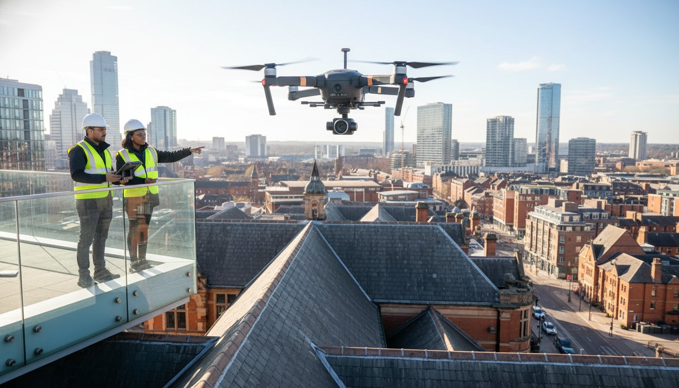
Why are London property managers still paying upwards of £3,000 just to erect scaffolding for a simple visual inspection? In a city where access is restricted and lead times often stretch beyond 21 days, the traditional approach to maintenance is becoming a significant financial liability. A professional drone roof survey london offers a smarter alternative, capturing high-resolution data from chimneys and valleys that often remain invisible from the ground.
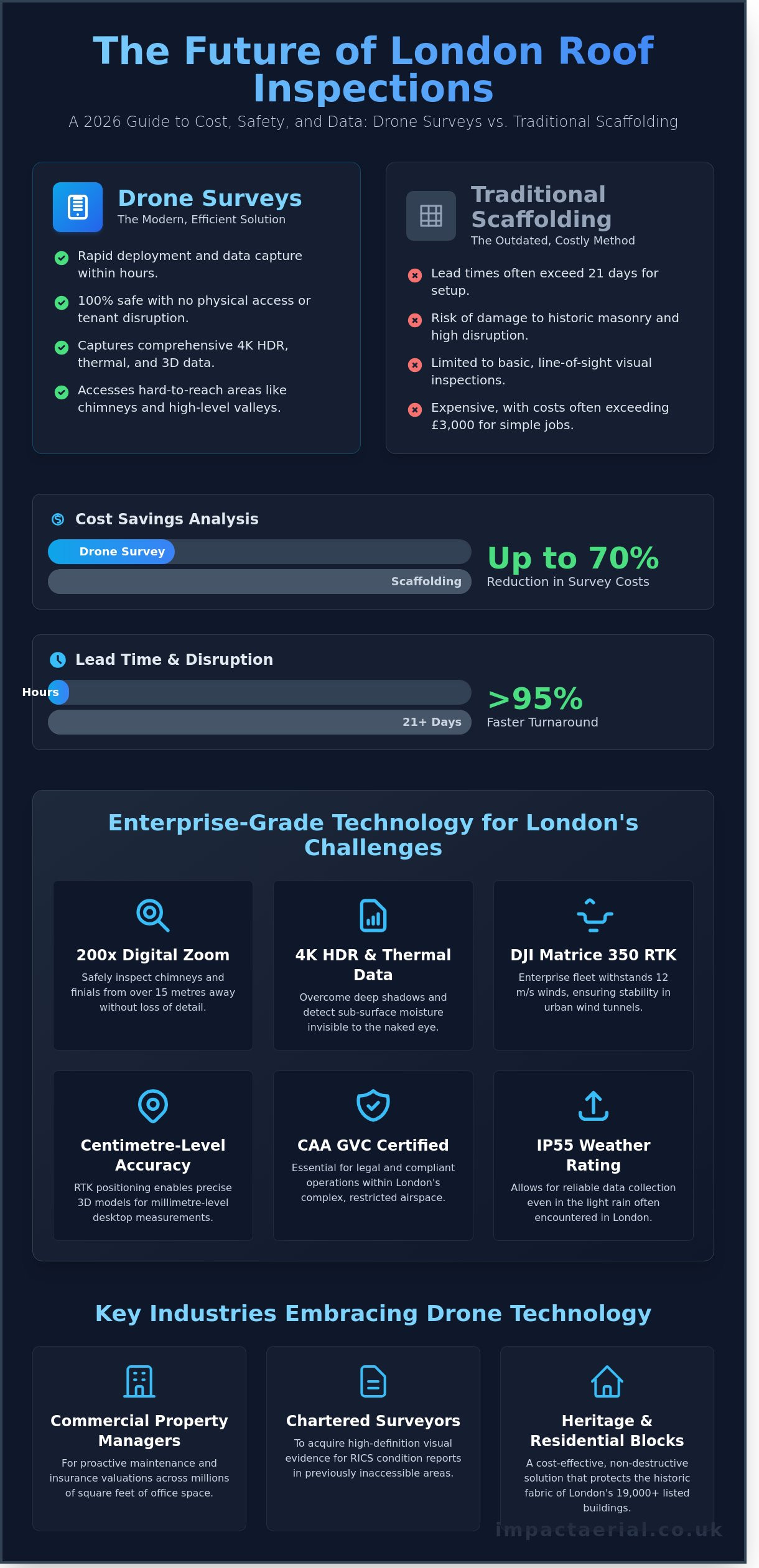
You likely already know that scaffolding is not just expensive; it’s a logistical nightmare that disrupts tenants and risks damage to historic masonry. This 2026 guide promises to show you how professional aerial inspections deliver 100% safety and superior data while reducing your survey costs by as much as 70% compared to traditional methods. We’ll examine the latest CAA GVC compliance standards, fixed-cost pricing models, and how our 4K HDR fleet provides the high-resolution condition report you need for total peace of mind.
Key Takeaways
- Learn why a professional drone roof survey london provides a safer, more cost-effective alternative to traditional scaffolding while delivering superior high-resolution data.
- Understand how enterprise-grade DJI technology overcomes the unique challenges of London’s micro-climates, wind tunnels, and complex urban architecture.
- Realise significant cost savings and reduced lead times by switching from weeks of scaffolding setup to just hours of precision aerial flight.
- Navigate the legal requirements of London’s restricted airspace, including why CAA GVC certified pilots are essential for compliant urban operations.
- Discover how meticulous risk management and expert post-production analysis provide the peace of mind required for managing high-value London property assets.
What is a Professional Drone Roof Survey in London?
A professional drone roof survey in London is a non-intrusive aerial inspection that utilises advanced Unmanned Aerial Vehicles (UAVs) to capture high-resolution imagery and data of building envelopes. By 2026, the industry has transitioned from basic visual checks to sophisticated, data-driven asset management. This methodology allows for the rapid assessment of structures without the need for expensive scaffolding or high-access equipment, providing a safer and more efficient alternative to traditional methods.
London’s skyline features a unique blend of 18th-century heritage and modern glass structures. Operating within these high-density urban environments requires specialised knowledge of CAA GVC certification and local airspace restrictions. With over 19,000 listed buildings and complex clusters of high-rise developments, a drone roof survey london must account for tight flight paths and stringent safety protocols to ensure every centimetre of the structure is documented accurately.
Standard components of a modern survey include 4K HDR video and high-resolution stills. For added peace of mind, thermal mapping is frequently deployed to identify sub-surface moisture and insulation failures. These sensors detect heat signatures that remain invisible to the naked eye, allowing property owners to pinpoint leaks before they cause structural damage.
The Evolution of Aerial Inspections
Inspections have progressed from basic photography to centimetre-accurate data collection. By 2026, 4K HDR sensors have largely replaced the requirement for physical “hand-on” tile checks in 95% of commercial cases. We use photogrammetry to generate precise 3D models of complex London rooflines. These models allow surveyors to take millimetre-level measurements from their desktop, significantly reducing the time spent on-site while increasing the accuracy of the final report.
Key Industries Benefiting from Drone Surveys
Three primary sectors now rely on drone technology for their property maintenance strategies:
- Commercial Property Managers: Professionals overseeing the 23 million square feet of office space in central London use drone data for proactive maintenance and insurance valuations.
- Chartered Surveyors: Experts requiring high-definition visual evidence for RICS condition reports can now access areas that were previously unreachable.
- Heritage and Residential Blocks: For buildings where scaffolding costs can exceed £5,000 for a simple inspection, a drone roof survey london provides a cost-effective, non-destructive solution that protects the fabric of the building.
The Technology Behind High-Precision London Surveys
Executing a high-precision drone roof survey london requires more than a standard off-the-shelf aircraft. The capital’s unique architecture, coupled with narrow wind tunnels created by skyscrapers in the City and Canary Wharf, demands enterprise-grade stability. Professional operators utilise the DJI Enterprise fleet, such as the Matrice 350 RTK, which is engineered to withstand wind speeds of up to 12 metres per second. These aircraft aren’t just drones; they’re flying workstations equipped with dual-redundancy systems for batteries and flight controllers, ensuring absolute safety when operating over congested urban streets.
The sensor is the heart of the survey. We use large-format sensors that excel in High Dynamic Range (HDR) capture. This is vital for London properties where tall neighbouring buildings cast deep shadows across roof pitches. Without HDR, a standard camera would lose all detail in these dark areas, potentially missing cracks or slipped tiles. For added peace of mind, our professional aerial inspection services provide the technical rigour needed for complex insurance and structural claims.
Enterprise Hardware vs. Consumer Drones
Consumer drones lack the optical zoom capabilities required for safe, detailed inspections. Our enterprise payloads feature up to 200x digital zoom, allowing us to inspect Victorian chimneys and ornate finials from a distance of 15 metres without compromising safety. A global shutter captures the entire frame simultaneously to prevent the motion blur or “jello effect” that occurs with cheaper rolling shutter sensors during flight. This hardware ensures every millimetre of the masonry is sharp and measurable.
- RTK Positioning: Real-Time Kinematic satellite data provides centimetre-level accuracy for 3D modelling.
- Obstacle Avoidance: Six-directional sensing prevents collisions in tight London alleyways.
- IP55 Rating: Allows for data collection in the light rain often encountered during London winters.
Thermal and Multispectral Data
Standard photography only reveals surface issues. We use high-resolution thermal sensors to identify heat loss and moisture ingress that the naked eye can’t see. On commercial flat roofs, wet insulation retains heat differently than dry areas. By flying at dusk, we spot these “hot spots” or “cold spots” that indicate trapped water, preventing costly structural rot. Integrating this data into a wider drone survey workflow allows for a 360-degree view of building health.
Multispectral data adds another layer of intelligence. It identifies the early stages of organic growth, such as moss or lichen, by analysing light signatures invisible to humans. Catching this growth early prevents the premature decay of porous London brickwork and limestone. It’s a proactive approach that moves beyond simple reactive maintenance, giving asset managers a clear 2026 roadmap for their property portfolios.
ROI Analysis: Drone Surveys vs. Traditional Access Methods
The financial risk of deferred maintenance in the capital is substantial. Industry data from 2025 suggests that minor leaks left unaddressed for six months often escalate into structural repairs exceeding £20,000 for mid-sized commercial blocks. For property managers, the “cost of doing nothing” is rarely zero. A drone roof survey london acts as a high-speed diagnostic tool that identifies defects before they necessitate major capital expenditure. While traditional methods require weeks of logistical planning, a drone flight is often completed in a single morning, providing immediate clarity on the building’s health.
- Lead Times: Scaffolding typically requires 14 to 21 days for permit approvals and assembly. A UAV deployment requires only a few hours of site preparation and flight time.
- Health and Safety: By removing the need for personnel to work at height, you eliminate the primary cause of workplace fatalities in the UK construction sector. Our operations remain entirely ground-based.
- Sustainability: Our fleet of electric UAVs produces zero operational emissions. This contrasts sharply with the carbon-heavy logistics of transporting tons of steel scaffolding or operating diesel-powered cherry pickers across London’s Ultra Low Emission Zone (ULEZ).
The Scaffolding Cost Trap in London
In 2026, the hidden expenses of traditional access in London often outweigh the actual labour costs. Pavement licences from local councils like Westminster or the City of London can cost hundreds of pounds per week. Parking suspensions on busy thoroughfares and the mandatory installation of scaffold alarms for security add further layers of expense. Drones serve as the ideal “first-response” method. They allow surveyors to pinpoint a specific leak location. If scaffolding is eventually required, it’s only erected exactly where it’s needed, which saves thousands in unnecessary rental fees and permit extensions.
Data Quality and Shareability
The transition from manual inspections to “digital twins” has revolutionised how data is handled. High-resolution 4K footage and 45-megapixel stills provide a level of detail that a surveyor on a ladder cannot match. This data is easily shared with contractors to secure fixed-price quotes, preventing the budget creep common in complex roof repairs. For storm damage claims, having date-stamped, high-definition evidence accelerates the insurance payout process by providing indisputable proof of the building’s condition. You can find more detail on these efficiencies in this drone roof survey comparison guide. Our CAA GVC Certified pilots ensure that every byte of data gathered meets the highest professional standards, giving you total peace of mind during the claims process.
Navigating London’s Complex Airspace and Legal Requirements
Operating a professional drone roof survey london involves navigating some of the most strictly regulated airspace in the world. Central London is a patchwork of Flight Restricted Zones (FRZs) protecting Heathrow, London City Airport, and RAF Northolt. Flying within these zones without explicit permission from National Air Traffic Services (NATS) is a criminal offence under the Air Navigation Order 2016. We manage the entire coordination process, liaising with the Metropolitan Police and relevant air traffic control towers to ensure every flight is fully authorised and legal.
Safety in the capital’s congested boroughs like Westminster or Camden requires more than just technical skill. It demands a rigorous approach to risk management. We provide £5 million in commercial liability insurance for every project, offering the necessary protection for high-value commercial assets and the public. This level of cover is a prerequisite for most Tier 1 contractors and property management firms operating in the city. We don’t take risks with your liability or our reputation.
Permissions and Authorisations
Professional operators must hold the correct credentials for urban environments. While a basic drone license might suffice for rural areas, London missions often fall into the “Specific” category. This requires a CAA GVC (General Visual Line of Sight Certificate) and a formal Operating Authorisation. These documents allow us to fly heavier enterprise drones in areas where hobbyist flights are prohibited. We also prioritise privacy and GDPR compliance. Our protocols ensure that any incidental imagery of neighbours or the public is either not captured or is digitally masked during the data processing stage.
Safety Protocols in the Capital
London’s “urban canyons”—areas with tall, glass-fronted buildings—can cause GPS multi-pathing or signal interference. To counter this, we employ a Visual Observer (VO) on every complex drone roof survey london. The VO stays in constant radio contact with the pilot, monitoring the surrounding airspace for helicopters or cranes while the pilot focuses on the high-resolution data capture. Our drones are equipped with advanced obstacle avoidance sensors and redundant battery systems to prevent accidents in high-traffic environments.
- The 1:1 Rule: In urban drone operations, the 1:1 rule requires the pilot to maintain a horizontal safety distance from uninvolved people that is at least equal to the drone’s current altitude.
- Emergency Failsafes: Every aircraft is programmed with a “Return to Home” (RTH) protocol that triggers automatically if the command link is interrupted.
- Pedestrian Management: We use physical cordons and ground marshals in busy boroughs to keep the take-off and landing zones clear of foot traffic.
Choosing Impact Aerial for Your London Roof Survey
Selecting a partner for a drone roof survey london requires more than just finding an operator with a camera. It demands a team that understands the technical and regulatory complexities of the capital’s unique airspace. Impact Aerial brings years of expertise to every project, holding full CAA GVC certification to ensure every flight complies with the latest 2026 aviation standards. Our commitment to safety isn’t just a policy; it’s the foundation of our operations. We conduct meticulous risk assessments for every site, managing everything from pedestrian safety in busy streets to radio frequency interference in dense urban environments.
For added peace of mind, we maintain comprehensive commercial liability insurance, protecting your assets and our team throughout the process. Our end-to-end service ensures you aren’t left with raw data you can’t interpret. We guide you from the initial consultation through to post-production analysis that turns high-resolution imagery into actionable insights. This professional approach is why leading London estate managers and commercial developers trust us with their most sensitive structural assets.
Our Professional Methodology
We begin every project with a pre-flight site survey using advanced satellite data and real-time airspace maps. This allows us to identify potential hazards and flight restrictions before we even arrive on-site. Once we’re there, our pilots behave with the discretion and professionalism expected on a high-value estate or active construction site. You’ll receive a final report featuring high-resolution 4K and HDR imagery, meticulously organised and ready for immediate review by your architect or builder. We provide the technical depth required for precise structural assessments without the need for expensive scaffolding.
Ready to Organise Your Survey?
Waiting for a visible leak to appear is the most expensive maintenance strategy a property owner can adopt. Industry data suggests that reactive repairs often cost five times more than proactive maintenance. Our 3-step booking process makes it easy to stay ahead of structural issues:
- Step 1: Request a Quote. Contact us for a bespoke London quotation based on your specific property coordinates and requirements.
- Step 2: Site Execution. Our team handles all flight planning, notifications, and on-site data gathering.
- Step 3: Data Delivery. Receive your high-resolution data and professional report within 48 hours of the flight.
Don’t leave your roof’s integrity to chance. Contact the Impact Aerial team today to secure your 2026 survey slot. You can also explore our professional drone services to see how we support commercial clients across the wider UK with leading aerial data solutions.
Future-Proof Your Property Maintenance with Precision Aerial Data
As we move into 2026, the transition from costly scaffolding to high-precision aerial intelligence has become a commercial necessity for London property managers. Investing in a professional drone roof survey london eliminates the inherent safety risks of working at height while reducing inspection timelines by up to 70% compared to traditional access methods. Impact Aerial provides the technical expertise required to navigate the capital’s complex Flight Restriction Zones and stringent urban regulations. Our operations are led by CAA GVC Certified Pilots and backed by £5m commercial liability insurance for added peace of mind. We utilise DJI Enterprise grade equipment to capture high-resolution 4K HDR imagery and detailed photogrammetry, identifying structural defects that manual inspections often miss. This data-driven approach ensures your maintenance budgets are spent where they’re needed most. Don’t leave your building’s structural integrity to chance. We’re ready to help you streamline your next inspection with a solution that prioritises safety, compliance, and actionable results.
Request a Bespoke London Drone Roof Survey Quote
Frequently Asked Questions
Do I need permission from the council for a drone roof survey in London?
You don’t usually need permission from the local council for a drone roof survey on private property, but you must comply with Civil Aviation Authority (CAA) flight regulations. Our pilots manage all necessary clearances for Flight Restricted Zones (FRZs) near major hubs like Heathrow or London City Airport. We ensure every operation follows the latest CAP 722 guidelines to guarantee legal compliance and safety for your project.
How much does a drone roof survey cost in London in 2026?
While individual project requirements vary, 2026 industry data from the Drone Safe Register indicates that a standard residential drone roof survey london typically ranges from £250 to £600. Commercial inspections for larger structures involve more complex data-gathering and often start at £800. These figures reflect the high-quality 4K imagery and professional risk assessments included in a standard specialist package for peace of mind.
Can a drone survey detect a leak that isn’t visible to the naked eye?
Drones detect leaks by using thermal sensors to identify moisture trapped under roofing membranes that isn’t visible to the human eye. These radiometric cameras highlight temperature differentials, where damp patches retain heat differently than dry areas. This advanced data-gathering method allows us to pinpoint ingress points with 95% accuracy before they cause structural damage or internal damp issues in your building.
What happens if it rains on the day of my scheduled drone survey?
We’ll reschedule your flight if it rains because moisture can interfere with the drone’s sensitive electronics and obscure the camera lens. Safety is our primary concern, and high winds or precipitation prevent us from capturing the high-quality, stable footage required for a professional report. Our team monitors Met Office forecasts 24 hours in advance to provide you with timely updates and ensure operational success.
Is the drone footage good enough for an insurance company to accept?
Insurance companies and loss adjusters widely accept our drone footage because it provides high-resolution, timestamped evidence of a roof’s condition. We use DJI Enterprise commercial drones to capture 4K HDR imagery that offers more detail than traditional ladder inspections. Since we’re CAA GVC Certified, the data we provide meets the professional standards required for formal claims and detailed structural assessments.
How close to my neighbours’ windows will the drone fly?
Our pilots adhere to strict UK privacy laws and CAA regulations, ensuring the drone remains a safe distance from neighbouring windows. Under current UK GDPR and Article 8 of the Human Rights Act, we focus our sensors exclusively on your property to protect local residents’ privacy. We use high-zoom lenses to capture detail from a distance, so we don’t need to fly directly alongside adjacent buildings.
Do I need to be present at the property during the drone survey?
You don’t need to be present at the property during the survey as long as we have clear access to the site. We conduct a thorough pre-flight site assessment remotely and can complete the entire inspection while you’re at work or away from the premises. Once the flight is finished, we’ll upload the high-quality data to a secure cloud folder for you to review at your convenience.
How long does it take to receive the final report and footage?
You’ll typically receive your final inspection report and high-resolution footage within 24 to 48 hours of the flight’s completion. This timeframe allows our technicians to process the raw data and highlights any specific defects found during the drone roof survey london. For urgent structural issues, we can often provide a preliminary gallery of the 4K images on the same day as the survey for immediate review.
