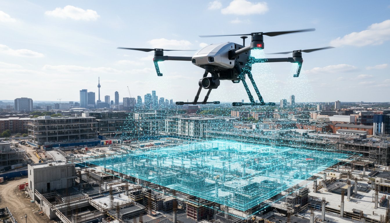
The actual flight time of a commercial UAV represents less than 15% of the total project lifecycle, yet many site managers still mistake a quick launch for a finished report. If you’re managing a high-stakes site in Birmingham or London, you’ve likely felt the pressure of a looming deadline while waiting for data that seems stuck in a processing queue. You need to know exactly how long does a drone survey take to avoid the 25% scheduling overrun often caused by poor planning or unexpected British weather. It’s vital to distinguish between the minutes spent in the air and the days required for professional data-gathering and analysis.
This guide outlines the realistic timescales for drone surveys in 2026, covering everything from CAA-mandated risk assessments to the final delivery of 4K digital twins. We’ll explain why high-quality photogrammetry often requires a 48-hour window for precision processing and how our GVC certified team ensures your project stays compliant. You will gain a clear roadmap of the survey process, giving you the peace of mind to schedule your next build without the fear of hidden delays.
Key Takeaways
- Distinguish between on-site flight time—typically one to four hours for standard commercial properties—and the total project turnaround to manage your development schedule effectively.
- Identify how UK-specific variables, including unpredictable weather conditions and CAA flight restrictions, can influence your data-gathering window and overall timeline.
- Compare the timescales for different applications, from rapid high-resolution roof inspections to more complex topographic land surveys that require precise Ground Control Points.
- Understand the four essential stages of the process to accurately estimate **how long does a drone survey take** from the initial instruction through to final data delivery.
- Discover how employing CAA GVC certified pilots and DJI Enterprise technology can minimise mobilisation delays and streamline the delivery of high-quality survey results.
Estimating Your Drone Survey Timeline: On-Site vs. Total Turnaround
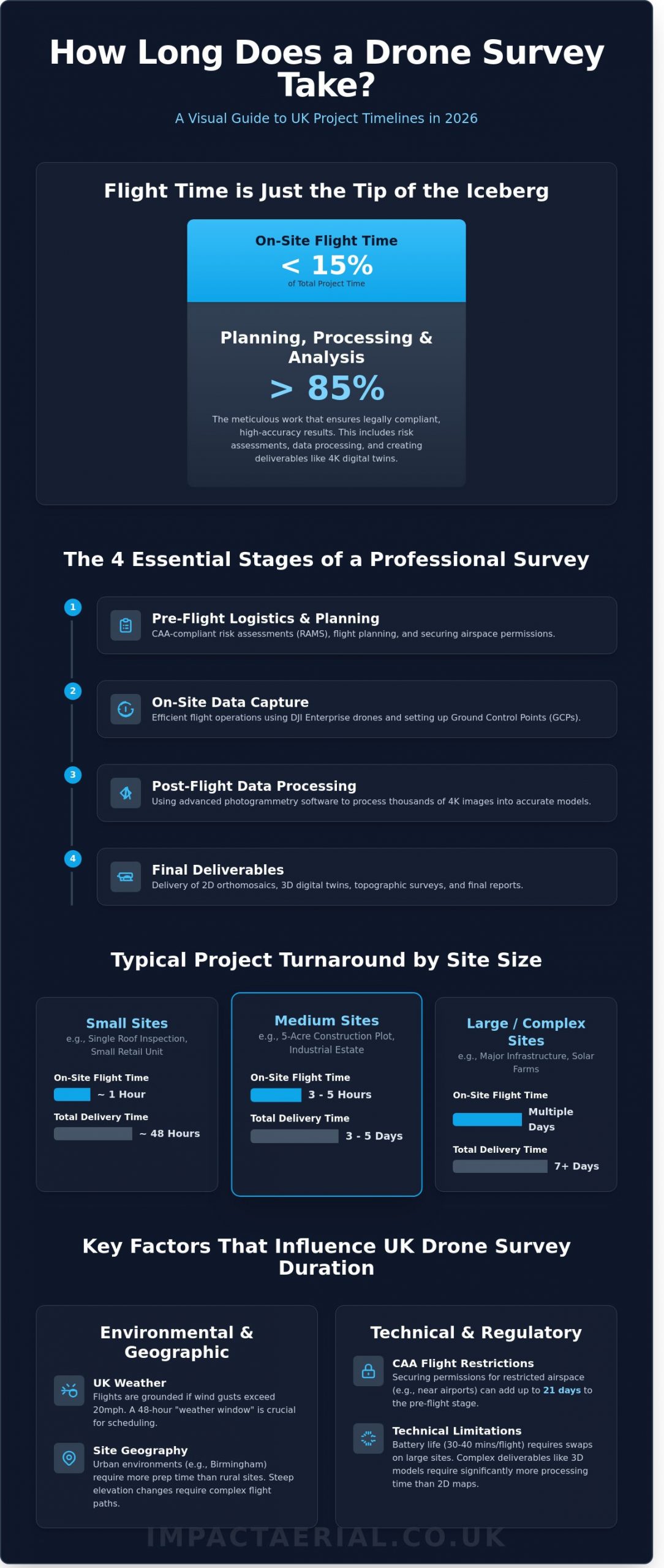
Understanding how long does a drone survey take requires a clear distinction between on-site duration and the total project turnaround. Many stakeholders assume the job is finished once the drone lands, but professional surveying is a multi-stage process. For a standard commercial property in the UK, the on-site flight time typically ranges from 1 to 4 hours. However, the full project lifecycle, from the initial instruction to the final delivery of data, usually spans 3 to 7 working days. This timeline ensures that every byte of data meets the high-resolution standards required for modern construction and engineering.
The Short Answer: Typical Timescales
Project duration scales with the complexity and size of the environment. We use specific benchmarks for our UK operations to ensure clients can plan their workflows effectively:
- Small sites: A single roof inspection or small retail unit takes approximately 1 hour on-site. We deliver the final processed report within 48 hours.
- Medium sites: A 5-acre construction plot or industrial estate requires 3 to 5 hours of active flight time. The full data package is delivered within 3 to 5 working days.
- Large/Complex sites: Major infrastructure projects or solar farms often involve multiple days on-site. Delivery typically starts at 7 working days due to the sheer volume of data.
Why Flight Time is Only the Tip of the Iceberg
The drone is a powerful data-gathering tool, yet it isn’t a magic wand. In professional surveying, roughly 70% of the work happens outside of flight hours. Before our DJI Enterprise drones leave the ground, we conduct meticulous pre-flight planning and CAA-compliant risk assessments. This preparation is vital for safety and legal adherence. After landing, the technical work begins. We process 4K HDR imagery through advanced photogrammetry software to ensure millimetre-level accuracy. This is why “instant” drone data is almost always a myth in high-stakes industries. Quality takes time. Our structured approach provides the peace of mind that the final results are both precise and legally compliant. When asking how long does a drone survey take, you must account for this vital post-processing phase that transforms raw images into actionable intelligence.
Key Factors That Influence Drone Survey Duration in the UK
Determining how long does a drone survey take requires looking beyond the flight itself. While a standard 10-hectare site might only require 45 minutes of actual airtime, the total project timeline is dictated by external variables and technical precision. We don’t just “turn up and fly”; we manage a complex set of environmental and regulatory hurdles to ensure data accuracy.
Environmental and Geographic Variables
UK weather patterns are the primary cause of scheduling shifts. Most commercial drones, such as the DJI Matrice 350 RTK, have a maximum wind resistance of approximately 27mph. If gusts exceed 20mph, data quality often degrades due to sensor instability. We typically build a 48-hour “weather window” into our project timelines to account for these shifts. This ensures we capture high-quality data without risking the equipment or the accuracy of the photogrammetry.
Location geography also changes the pace of work. A rural survey in the West Midlands involves fewer obstacles than a complex flight in Birmingham city centre. Urban environments require detailed ground control and pedestrian management, which can double the preparation time. Topographical challenges, like 50-metre elevation changes or high-rise structures, require multi-level flight paths to maintain a consistent Ground Sample Distance (GSD). These technical adjustments are vital for the precision our clients expect.
Technical and Regulatory Requirements
Safety and compliance are at the heart of our operations. Every mission starts with a comprehensive Risk Assessment and Method Statement (RAMS). For restricted airspace near major airports, securing specific CAA permissions can take up to 21 days. It’s a meticulous process that cannot be rushed if you want to remain within the law. Understanding how long does a drone survey take involves accounting for these administrative lead times before the drone even leaves the van.
- Battery Management: A standard enterprise battery provides roughly 30 to 40 minutes of flight. Large-scale projects requiring 2,500+ high-resolution images will necessitate multiple battery swaps and cooling cycles.
- Deliverable Complexity: A simple 2D orthomosaic is processed much faster than a centimetre-accurate 3D digital twin or a detailed thermal inspection report.
- Site Access: Securing permissions from neighbouring landowners can add several days to the pre-flight phase.
For added peace of mind, our professional drone services ensure all regulatory and technical hurdles are cleared before the first propeller spins. The difference between a quick snapshot and a professional survey lies in this preparation. We focus on the details so that the final data is both actionable and legally compliant.
Comparing Timelines for Roof, Land, and Commercial Property Surveys
The specific application of the technology determines how long does a drone survey take more than any other factor. A CAA GVC certified pilot might complete a visual inspection of a 2,000 square metre warehouse in 90 minutes, whereas a full topographic land survey of the same site requires a multi-day commitment. Precision requirements and data density are the primary drivers of these differences. We categorise these timelines based on the complexity of the data capture and the subsequent processing required to deliver professional results.
Roof and Building Inspections
Roof inspections are the most efficient service we offer. For a standard commercial unit in the West Midlands, such as a distribution hub in Solihull or an industrial unit in Dudley, the on-site flight time rarely exceeds two hours. These projects focus on high-resolution 4K stills and 60fps video to identify structural defects, leaks, or blocked guttering. Because these surveys produce individual files rather than a unified map, clients often receive the raw data within 24 hours. It’s a rapid process that provides immediate peace of mind for facility managers facing urgent maintenance issues.
Mapping and Photogrammetry Projects
Mapping projects are significantly more complex. When creating a 3D digital twin or a 2D orthomosaic, the pilot must capture thousands of overlapping images. To achieve sub-20mm accuracy, we must set out Ground Control Points (GCPs) across the site before the drone takes off. This preparation adds 2 to 4 hours to the on-site timeline. Data processing is the final hurdle. Stitching 1,500 high-resolution images into a single map requires immense computational power. Even with high-spec workstations using 128GB of RAM, rendering a 50-hectare site can take 12 to 18 hours of continuous processing.
Other specialised surveys have unique constraints that impact the delivery schedule:
- Thermal Solar Surveys: These must occur when solar irradiance exceeds 600W/m². In the UK, this usually limits flight windows to between 10:00 and 14:00 on clear days.
- Construction Monitoring: This is a longitudinal process. We visit a site at 14-day intervals over a 12-month build programme to document progress and ensure the project stays on track.
- Topographic Land Surveys: These often require a 3 to 5-day turnaround to allow for the integration of GPS data and the generation of detailed CAD drawings.
Understanding these variables helps project managers plan effectively. While a simple aerial photograph is instant, a professional survey is a technical exercise in data management. When asking how long does a drone survey take, always account for the 48-hour window typically needed for high-quality data validation and reporting after the drone has landed.
The 4-Stage Drone Survey Process: From Instruction to Deliverables
Understanding how long does a drone survey take requires a transparent look at the operational workflow. It’s a common misconception that the process begins and ends with the drone in the air. At Impact Aerial, we divide every project into four distinct phases to ensure 99.9% data accuracy and total CAA compliance. Since the 2024 update to GVC standards, our meticulous approach ensures that even the most complex 20-hectare sites are handled with surgical precision.
- Phase 1: Pre-flight Planning: We conduct detailed site research, establish flight boundaries, and complete mandatory risk assessments.
- Phase 2: Mobilisation: This is the physical deployment where our GVC certified pilots capture high-resolution imagery or LiDAR data on-site.
- Phase 3: Data Processing: Raw files undergo photogrammetry and quality assurance checks to create 2D orthomosaics or 3D models.
- Phase 4: Delivery: Final assets are uploaded to a secure cloud portal, providing clients with instant access to actionable insights.
Pre-Flight: The Secret to a Smooth Survey
Success is decided before the rotors start spinning. We use advanced mapping tools to review site boundaries and identify hazards like overhead power lines or restricted airspace that could delay progress. By coordinating directly with site managers, we reduce operational disruption by roughly 35% compared to traditional ground surveys. The pre-flight window is the 24-48 hours before arrival where final weather forecasts and site access protocols are locked in.
Post-Production: Turning Imagery into Insight
Data is only valuable if it’s usable. Our editors filter through hundreds of 4K HDR images to select the clearest frames for your report. When inspecting solar arrays, our thermal analysis identifies ‘hot spots’ where cells have failed, often detecting temperature spikes of 15°C above the baseline. This technical review ensures every centimetre of data aligns with your specific brief before it reaches your desk. If you need precise data for your next project, contact our expert team today for a consultation.
When clients ask how long does a drone survey take, they’re often surprised that the technical processing in Phase 3 takes longer than the flight itself. For a standard commercial roof inspection, the flight might take 90 minutes, but the rigorous quality assurance checks ensure the final report is robust enough for legal or insurance purposes. This structured approach provides the peace of mind that every detail is captured safely and legally.
Minimising Delays: How Impact Aerial Streamlines the Process
Impact Aerial optimises every stage of data collection to ensure your project remains on schedule. We utilise the latest DJI Enterprise drones, such as the Matrice 350 RTK, which offer superior flight stability and longer battery life compared to standard consumer hardware. These drones capture high-resolution data up to 40% faster than older models, significantly reducing the time our pilots need to spend on-site. By using RTK (Real-Time Kinematic) positioning, we achieve centimetre-level accuracy without the need for excessive ground control points, which often shave hours off the initial setup phase.
Our strategic Birmingham base provides a logistical advantage for projects across the West Midlands. We can mobilise teams to sites in Birmingham, Coventry, or Wolverhampton within 60 to 90 minutes. This local presence eliminates the travel-related delays that often plague national providers. For added peace of mind, we carry £5m commercial liability insurance. This level of cover is a standard requirement for 95% of Tier 1 construction sites in the UK. Having this in place ensures immediate site access, preventing the administrative bottlenecks that occur when insurers need to vet under-insured operators.
Professionalism as a Time-Saving Tool
Amateur pilots often cause project overruns because they lack a deep understanding of UK airspace restrictions. A single oversight in flight planning can result in a grounded mission or a fine from the Civil Aviation Authority (CAA). Our CAA GVC certified pilots are experts in navigating complex regulations. We produce comprehensive Risk Assessments and Method Statements (RAMS) that achieve a 98% first-time approval rate from site managers. This methodical preparation is a cornerstone of our drone property surveys, ensuring we start flying the moment we arrive on-site.
Next Steps for Your Project
To accurately assess how long does a drone survey take for your specific requirements, we need a detailed brief. A clear scope of work allows us to account for site-specific variables like terrain complexity and local flight restrictions. When you get in touch, please include the following details:
- The site postcode and boundaries.
- The required data outputs, such as 2D orthomosaics or 3D models.
- Any specific site access requirements or safety inductions.
Providing this information upfront allows us to calculate a precise project timeline and a fixed-fee quote within 24 hours. You can contact Impact Aerial for a bespoke survey timeline to ensure your next project is delivered with technical precision and professional reliability.
Accelerate Your 2026 Project Timelines with Expert Aerial Data
Determining how long does a drone survey take involves balancing rapid on-site capture with meticulous data processing. Most commercial property inspections in the UK now require less than 1 day on-site, with final 4K HDR reports typically delivered within 48 to 72 hours. This efficiency represents a 70% time saving compared to traditional manual surveying methods. At Impact Aerial, we don’t just fly; we provide a structured 4-stage process that ensures safety and precision at every turn. Our CAA GVC Certified pilots operate the latest DJI Enterprise 4K HDR drone fleet to capture every millimetre of your assets. For added peace of mind, we carry £5m commercial liability insurance, ensuring your site remains compliant with all current UK aviation regulations. Don’t let outdated inspection methods stall your progress. Our team is ready to provide the high-quality insights you need to keep your development on track and within budget. We look forward to helping you streamline your next project.
Request a Professional Drone Survey Quote Today
Frequently Asked Questions
How long does a drone roof survey take on-site?
A standard drone roof survey typically takes between 30 and 90 minutes on-site. This timeframe allows our CAA GVC certified pilots to conduct a mandatory pre-flight safety brief and capture high-resolution 4K HDR imagery of the entire structure. Complex industrial roofs with multiple levels or technical obstructions might extend this duration to 120 minutes. We ensure every angle is covered for a comprehensive inspection without the need for expensive scaffolding.
Can you perform a drone survey in the rain or high winds?
We don’t operate in active rain or winds exceeding 20 miles per hour to ensure data precision and flight safety. While our DJI Enterprise fleet features IP-rated weather resistance, moisture on the lens distorts the 4K imagery required for professional surveys. High winds also deplete batteries 30% faster; this compromises the stability needed for accurate photogrammetry. We prioritise safety and quality to provide total peace of mind for our clients.
How long does it take to receive the processed drone data?
You will typically receive your processed drone data within 24 to 72 hours of the flight being completed. Standard high-definition imagery and raw video files are often delivered via a secure download link within one working day. More complex data-gathering projects involving detailed inspection reports or topographical maps require additional time for analysis. We aim to deliver 95% of our standard survey reports within 3 working days.
Does the size of the site significantly change the survey time?
Site size is the primary factor in determining how long does a drone survey take for a specific project. A compact 1-hectare site might require only 20 minutes of flight time, whereas a 20-hectare construction development often takes 4 to 6 hours to map fully. Larger sites require multiple battery swaps and more complex flight paths to maintain the 80% image overlap needed for high-quality data-gathering and accurate mapping.
Do I need to be present during the drone survey?
You don’t need to be present on-site during the drone survey as long as we have authorised access to the area. Our pilots handle all site risk assessments and CAA compliance requirements independently. We provide a digital confirmation once the data capture is complete; this allows you to continue with your day while we manage the technical operations. Many of our commercial clients prefer this remote approach for its efficiency and minimal disruption.
What happens if the drone survey is delayed by weather?
We reschedule weather-delayed surveys for the next available clear window, usually within 48 hours of the original booking. Our team monitors Met Office forecasts 24 hours in advance to provide early warnings of potential disruptions. Safety is our absolute priority, and we won’t fly if conditions risk the integrity of your data or the safety of the public. Your booking remains secured, and we don’t charge additional fees for weather-related rescheduling.
How much lead time is required to book a commercial drone survey?
We generally require a lead time of 3 to 7 days to book a commercial drone survey. This period allows us to complete necessary airspace checks, obtain any required permissions from the CAA, and perform a detailed desktop risk assessment. While we can occasionally accommodate emergency inspections within 24 hours, the 7-day window ensures all regulatory paperwork is perfectly in order. This meticulous planning is essential for maintaining our high safety standards.
Does a 3D model take longer to produce than 2D images?
Processing a 3D digital twin takes approximately 2 to 3 times longer than delivering standard 2D aerial photographs. While 2D images are often available within 24 hours, a 3D model requires intensive photogrammetry processing that can take 48 to 72 hours. This process involves stitching together hundreds of individual HDR images to create a centimetre-accurate representation of your asset. The resulting model provides a far more detailed level of insight for your project team.
