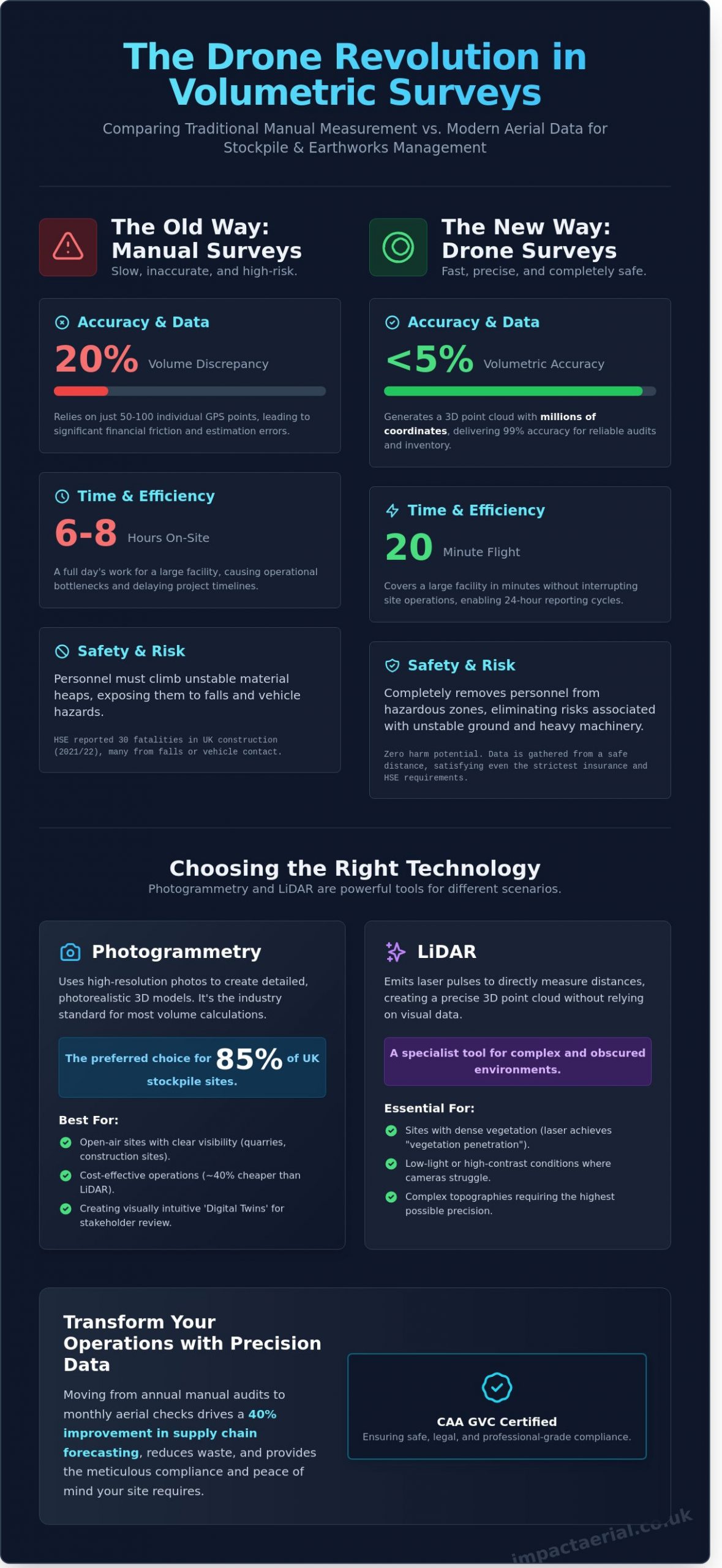
Research suggests that manual stockpile measurements often carry volume discrepancies as high as 20%, leading to significant financial friction during month-end audits. You already know that sending a surveyor to climb unstable material heaps isn’t just slow; it’s a liability risk that your insurance provider would rather you avoid. Relying on outdated methods instead of a professional drone survey for volume calculations creates a frustrating bottleneck that delays project timelines and leaves your data open to human error.
This guide demonstrates how professional aerial data gathering delivers sub-5% volumetric accuracy while completely removing personnel from hazardous zones. You’ll learn how to achieve high-precision 3D models for earthworks and transition to 24-hour reporting cycles for better site management. We’ll explore the technical workflow of photogrammetry and how working with CAA GVC certified pilots provides the meticulous compliance and peace of mind your site operations require for these complex technical tasks.
Key Takeaways
- Learn how transitioning from manual measurement to aerial data acquisition eliminates safety risks while significantly reducing the time spent on-site.
- Discover how a professional drone survey for volume calculations achieves sub-5% accuracy, meeting the rigorous standards required for financial audits and inventory reporting.
- Understand the technical distinctions between photogrammetry and LiDAR to determine which high-resolution 3D modeling method best suits your specific site requirements.
- Gain insights into monitoring earthworks progress and managing stockpile inventories with precision data that tracks real-time changes against original designs.
- Identify the essential safety credentials and CAA GVC certifications necessary to ensure your aerial surveys are conducted with professional-grade compliance and liability insurance.
Understanding Drone Survey for Volume Calculations
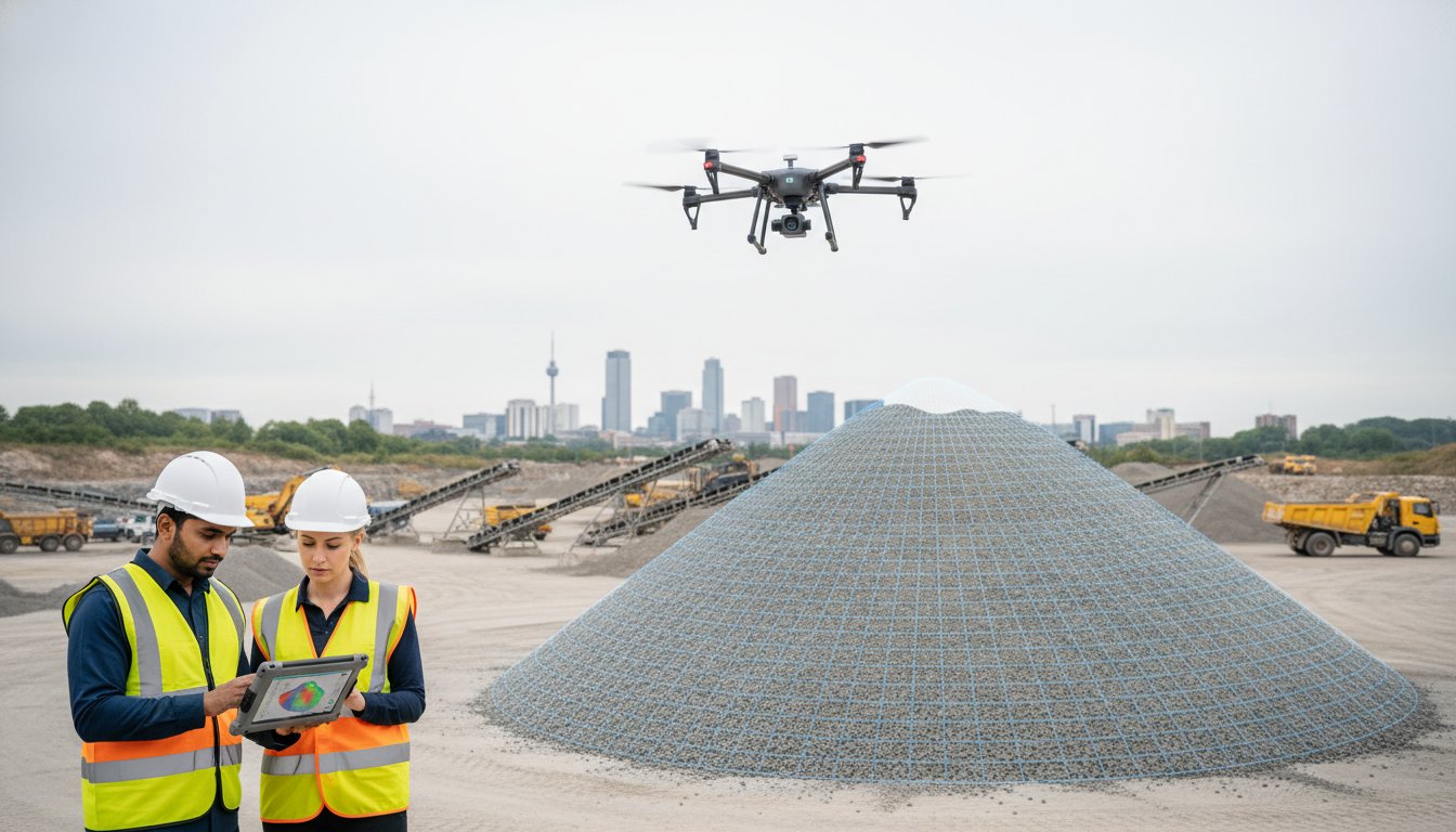
A drone survey for volume calculations involves deploying Unmanned Aerial Vehicles (UAVs) to capture thousands of high-resolution images across a site. These images are processed through photogrammetry to create a precise 3D digital twin. In the UK, this technology has replaced the outdated practice of “walking the pile,” where surveyors manually took measurements on unstable or shifting ground. It’s a fundamental shift from estimation to exact science.
For UK construction, mining, and waste management firms, accurate inventory is a legal and financial necessity. The Health and Safety Executive (HSE) reported 30 fatalities in the UK construction sector during 2021/22. Many of these incidents occurred due to falls or contact with moving vehicles. Aerial data acquisition removes personnel from these hazardous environments entirely. Our CAA GVC certified pilots provide this data without stopping site operations, offering a level of safety that manual methods can’t match.
Traditional vs Drone Volumetric Surveys
Manual surveys often take 6 to 8 hours to measure a large facility, yielding perhaps 50 to 100 individual GPS points. In contrast, a drone survey for volume calculations covers the same area in a 20-minute flight. This process generates a point cloud with millions of coordinates, providing a 99% accuracy level compared to traditional ground-based methods. Businesses moving from annual manual audits to monthly aerial checks typically see a 40% improvement in supply chain forecasting and waste reduction.
The Role of Digital Surface Models (DSM)
The Digital Surface Model (DSM) acts as the technical foundation for every calculation. It represents the top surface of all objects on site, including stockpiles and machinery. Software uses this data to establish a “base plane,” effectively drawing a floor beneath the material to calculate its true volume. High-resolution textures allow our team to distinguish between specific materials, such as Grade 6F2 crushed concrete and Type 1 sub-base. This ensures inventory reports are as precise as they are visually detailed.
Photogrammetry vs LiDAR: Choosing the Right Technology
Selecting the correct sensor technology is the most critical decision in a drone survey for volume calculations. Photogrammetry remains the industry standard for the majority of UK quarry and construction sites. This method relies on high-resolution cameras capturing hundreds of overlapping 2D images. Software then identifies millions of common “tie points” across these frames to triangulate a 3D point cloud. When flown at a height of 50 metres, a modern 45-megapixel sensor can achieve a Ground Sampling Distance (GSD) of 1.2cm, providing a level of detail that traditional ground-based GPS methods can’t match.
LiDAR (Light Detection and Ranging) operates on a different physical principle. Instead of passive light, the sensor emits up to 240,000 laser pulses per second. It measures the “Time of Flight” for each pulse to bounce back, creating a direct 3D measurement of the environment. While photogrammetry requires visual features to stitch images, LiDAR creates its own data points. This makes it a specialist tool for complex topographies where visual data alone fails to provide the required precision.
For 85% of UK stockpile measurements, high-resolution photogrammetry is the preferred choice. It’s significantly more cost-effective and provides a photorealistic “Digital Twin” that stakeholders can visually inspect. For projects requiring this level of technical precision, choosing an operator with CAA GVC certification ensures data is gathered safely and legally while maintaining high standards of accuracy.
When to Prioritise Drone Photogrammetry
Photogrammetry is the most efficient tool for open-air sites with clear visibility. It excels at measuring stockpiles of aggregate, soil, or coal where the material surface is clearly visible from above. Because the equipment is lighter and the processing more streamlined, it reduces operational costs by roughly 40% compared to LiDAR. The resulting 3D models are also visually intuitive, allowing site managers to identify specific materials or safety hazards directly from the map.
When LiDAR is Essential for Volumes
LiDAR becomes necessary when the ground is obscured. In the UK, this often involves measuring earthwork volumes on sites with dense vegetation or canopy cover. A laser pulse can find small gaps between leaves to hit the actual ground, a process known as “vegetation penetration.” It’s also vital for high-contrast environments or low-light conditions where traditional cameras struggle. If your drone survey for volume calculations involves “ground stripping” digital data from a wooded area, LiDAR is the only reliable solution.
Achieving Precision: RTK, GCPs, and Accuracy Standards
A common concern from site managers and financial controllers involves the reliability of aerial data for year-end audits. They often ask if a drone survey for volume calculations can truly stand up to the scrutiny of a balance sheet. The answer is yes. When executed by CAA GVC Certified professionals, drone-derived volumes achieve a 1% to 3% accuracy threshold. This directly rivals, and often exceeds, the results from traditional total stations. Ground-based surveyors might take 500 points across a stockpile; a drone captures 50,000 points per square metre, providing a far more granular digital twin.
Impact Aerial maintains this standard by strictly using DJI Enterprise hardware. Consumer-grade drones lack the mechanical shutters and high-performance sensors required for survey-grade work. A DJI Mavic 3 Enterprise, for example, uses a 20MP 4/3 CMOS sensor that captures data at 0.7-second intervals. This eliminates the “rolling shutter” distortion that causes measurement drift in cheaper models. It’s the difference between a professional audit and a rough estimate. We ensure that 1,000 cubic metres of aggregate is reported as 1,000 cubic metres, not 1,080.
RTK (Real-Time Kinematic) Explained
RTK technology acts as the foundation of high-accuracy mapping. Our drones communicate with a local base station or an NTRIP network to correct GPS data in real-time. This process provides horizontal accuracy within 1cm and vertical accuracy within 2cm. By georeferencing every image to a specific coordinate system, we remove the guesswork. It allows us to overlay surveys from January and June with perfect alignment. You don’t have to worry about shifting data when tracking monthly depletion rates.
The Importance of Ground Control Points (GCPs)
While RTK provides the positioning, Ground Control Points act as the physical anchor for the project. These are high-visibility markers placed across the site and measured with a GNSS rover. We typically deploy 5 to 8 GCPs per 10 hectares on active UK construction sites. This redundancy provides 100% peace of mind for audit-trail compliance. If a financial auditor questions the digital model, the GCPs serve as the verifiable ground truth. They prove the drone survey for volume calculations is accurate to the centimetre across the entire site area.
Practical Applications: Stockpiles, Earthworks, and Landfills
A professional drone survey for volume calculations transforms how site managers handle bulk material data. You don’t have to rely on manual estimations that often carry a 10% to 15% margin of error. Our aerial data-gathering techniques provide sub-5cm vertical accuracy, ensuring that financial reporting and operational planning are based on hard facts. It’s the most reliable way to maintain a clear overview of site assets without the safety risks associated with traditional ground-based surveying.
Quarry managers use these surveys for precise month-end stock reporting. Having an exact figure for extracted minerals or processed aggregates prevents discrepancies in the balance sheet. In landfill management, we measure remaining “void space” to assist with long-term capacity planning and regulatory compliance. Civil engineering projects, particularly road and rail embankments across the West Midlands, benefit from our ability to calculate exact material requirements. This precision prevents the costly over-ordering of fill materials and ensures project timelines remain intact.
Stockpile Volume Measurement and Monitoring
We automate the measurement of gravel, sand, coal, and recycled aggregates using advanced photogrammetry. Our process removes the safety risk of surveyors climbing unstable piles. Clients receive professional PDF reports featuring 3D visualisations that help non-technical stakeholders visualise the site. Regular aerial audits help firms reduce inventory “shrinkage” and accounting errors by approximately 4% compared to legacy measurement techniques.
Cut and Fill Analysis for Site Preparation
Comparing current ground levels against the proposed architectural CAD model is essential for site preparation. Our drone survey for volume calculations identifies the exact amount of soil that needs to be moved, exported, or imported. If a project manager miscalculates soil volume by even 500 cubic metres, it results in significant unbudgeted haulage expenses. Our data allows for the optimisation of on-site logistics, which has been shown to reduce machinery fuel consumption by 12% through more efficient route planning. For added peace of mind, our CAA GVC Certified pilots ensure all data is captured safely and in full compliance with UK aviation law.
Ready to improve your site accuracy? Contact our professional drone survey team to discuss your volume calculation requirements.
Partnering with Impact Aerial for Professional Surveys
Choosing a partner for a drone survey for volume calculations requires a focus on precision and legal compliance. Impact Aerial provides high-accuracy data-gathering services across Birmingham, the West Midlands, and the wider UK. We utilize DJI Enterprise technology, such as the Matrice 350 RTK equipped with high-resolution sensors, to deliver volumetric data that’s accurate to within 1-3cm. This level of detail is essential for construction managers and quarry operators who need to manage inventory without the 15% margin of error typical of manual measurement methods.
Safety isn’t just a buzzword for us; it’s our operational foundation. We maintain £5 million in commercial liability insurance and conduct rigorous site-specific risk assessments before every flight. Our pilots are CAA GVC certified, which is the current industry gold standard for commercial drone operations in the UK. This certification ensures we can operate in complex environments where uncertified hobbyists are legally barred from flying, providing the professional reliability your project demands.
The Impact Aerial Workflow
Our end-to-end service begins with a detailed consultation to understand your specific reporting needs. We follow a structured three-step process to ensure data integrity:
- Pre-flight planning: We identify site-specific hazards, check local airspace restrictions via NATS, and establish ground control points (GCPs) if required for sub-centimeter precision.
- On-site execution: Our pilots use automated flight paths to capture overlapping high-resolution imagery. This efficient data capture often takes less than 45 minutes for a standard 5-hectare site, causing zero downtime for your ground teams.
- Data processing: We transform raw imagery into actionable 3D models and detailed volumetric reports using advanced photogrammetry software, delivering results in your preferred CAD or GIS format.
Compliance and Peace of Mind
Relying on in-house hobbyists or uncertified operators exposes your business to significant legal and financial risks. Professional drone services provide the technical expertise and the legal framework necessary to protect your project. By 2026, holding a GVC certification will be the absolute legal baseline for any drone operator conducting safety-critical volumetric measurements on UK construction sites. For added peace of mind, we provide full documentation for every flight, ensuring your site remains 100% compliant with UK aviation law. Our meticulous approach guarantees that your drone survey for volume calculations is both legally sound and mathematically precise.
Optimise Your Site Intelligence with Precision Data
Precision in earthworks and stockpile management isn’t just a goal; it’s a financial necessity. By leveraging RTK technology and high-resolution photogrammetry, site managers can reduce measurement errors to under 3cm. Choosing a professional drone survey for volume calculations ensures your project stays on schedule while eliminating the safety risks associated with manual ground-based measurements. Impact Aerial provides the technical expertise required for these high-stakes environments. Our team consists of CAA GVC Certified Pilots who operate a specialised DJI Enterprise fleet capable of capturing 4K HDR data. For added peace of mind, we maintain £5m commercial liability insurance, ensuring every operation meets the highest safety standards. Whether you’re managing a 50-hectare landfill or a complex construction site, our data-gathering processes provide the authoritative results your stakeholders demand. Don’t let outdated methods compromise your project’s bottom line. Take the next step toward total site transparency today.
Request a Professional Drone Survey Quote
Frequently Asked Questions
How accurate is a drone survey for volume calculations?
A professional drone survey for volume calculations typically achieves a relative accuracy of 1% to 3% compared to traditional ground-based methods. When we use Ground Control Points (GCPs) or RTK-enabled drones, we maintain a vertical accuracy between 3cm and 5cm across the entire site. These 2024 industry standards ensure that your stockpile measurements are precise enough for financial auditing and inventory management. You’ll receive data that’s far more granular than the 5-meter grid spacing used in older manual techniques.
What materials can be measured using drone photogrammetry?
Drones effectively measure any bulk material with a visible surface, including sand, gravel, crushed stone, and coal. Our photogrammetry software processes thousands of data points to calculate the volume of irregular piles that manual surveyors often miss. We regularly provide volume reports for construction firms handling 10,000 cubic meters of earthwork or more. However, drones can’t measure liquids in tanks or materials hidden under dense forest canopies where the ground isn’t visible from the air.
Do I need to stop site operations during a drone survey?
You don’t need to halt site operations while we conduct the aerial survey. Our CAA GVC certified pilots operate at a safe distance from your machinery and personnel, ensuring zero downtime for your project. A typical 10-acre site takes less than 30 minutes to capture, compared to the 4 to 6 hours required for a ground crew. This non-intrusive approach eliminates the safety risks associated with surveyors climbing over unstable stockpiles or walking near heavy plant equipment.
How long does it take to get the volumetric report after the flight?
You’ll receive your completed volumetric report within 24 to 48 hours of the flight completion. Processing time depends on the total data volume, but a standard 500-image set is typically ready for analysis the next business day. For urgent requirements, our team can provide preliminary results even faster. This rapid turnaround allows site managers to make data-driven decisions based on current inventory levels rather than waiting a week for traditional survey results to be processed.
Is a drone survey cheaper than traditional surveying methods?
Drone surveys are generally 30% to 50% more cost-effective than traditional total station or GNSS methods. You save money by reducing the man-hours spent on-site and eliminating the need for expensive safety scaffolding or site shutdowns. For a medium-sized quarry, switching to aerial data-gathering can save over £1,500 per survey cycle. These savings come without sacrificing quality; they provide high-resolution 3D models that offer much higher data density than manual point collection.
What is the difference between a DSM and a DTM in volume surveys?
A Digital Surface Model (DSM) captures every feature on the site, including vehicles, buildings, and vegetation. In contrast, a Digital Terrain Model (DTM) filters out these objects to show only the bare earth surface. For accurate volume calculations, we use the DTM to ensure that a parked excavator or a temporary shed doesn’t artificially inflate your stockpile figures. Our processing software uses 2023-standard algorithms to strip away non-terrain features with 98% accuracy.
What regulations must a drone pilot follow for UK construction site surveys?
All pilots must hold a valid CAA GVC (General Visual Line of Sight Certificate) and maintain £5 million in commercial liability insurance. We strictly follow the UK Open Category or Specific Category rules, ensuring every flight is logged and risk-assessed according to CAP 722 guidelines. For added peace of mind, our team coordinates with local Air Traffic Control if your site falls within a Flight Restriction Zone (FRZ). Safety and legal compliance are our primary operational priorities.
Can drones measure volumes in indoor warehouses or under cover?
We can measure indoor volumes using specialized Elios 3 drones or handheld SLAM Lidar scanners that don’t rely on GPS signals. These internal surveys are essential for warehouses storing salt, grain, or biomass where traditional aerial drones can’t operate. Our indoor systems provide a 0.1% volume accuracy in confined spaces, ensuring your indoor inventory is as well-managed as your outdoor stockpiles. We provide these niche services to help facilities maintain 100% visibility of their assets regardless of the environment.
