Planning a critical project based on outdated satellite imagery or committing to the significant costs and timelines of traditional land surveying can introduce unacceptable risks and inefficiencies. For professionals across the UK’s construction, infrastructure, and environmental sectors, obtaining accurate, up-to-date topographical data is paramount. Fortunately, advanced drone technology has revolutionised this process. Professional high resolution aerial mapping uk services now deliver superior data with unparalleled speed, safety, and precision, directly addressing the limitations of older methods.
This comprehensive 2026 guide is designed to provide you with the essential knowledge to leverage this technology. We will demystify the process, explaining exactly what high-resolution aerial mapping entails, how photogrammetry works, and the key differences between drone, plane, and satellite data capture. You will discover the powerful outputs available-from detailed orthomosaics to interactive 3D models-and, crucially, learn how to select a fully qualified, CAA GVC Certified professional drone service in the UK that can meet your project’s specific requirements, ensuring top-quality results and complete peace of mind.
Key Takeaways
Understand how high-resolution mapping transforms hundreds of individual drone images into a single, highly detailed, and measurable digital asset for your site.
Learn the critical differences between drone, airplane, and satellite data capture to determine which method offers the best accuracy for your project’s budget and objectives.
Discover the diverse commercial applications for high resolution aerial mapping uk, from construction site monitoring to agricultural analysis, and how it drives tangible ROI.
Identify the essential credentials for a UK provider, focusing on CAA GVC certification and commercial liability insurance to ensure a safe, compliant, and successful outcome.
What is High-Resolution Aerial Mapping?
While standard satellite views from platforms like Google Maps offer a basic overview, they often lack the detail and currency required for professional decision-making. High-resolution aerial mapping moves beyond these limitations, using advanced drones to capture hundreds or thousands of overlapping, geo-tagged photographs of a site. For businesses across the country, professional high resolution aerial mapping UK services provide an unparalleled level of detail. This data-gathering technique, a modern application of aerial survey principles, is the foundation for creating powerful digital assets for analysis and planning.
To see this process in action, the following video provides a clear overview of a high-resolution aerial survey:
These individual images are then processed using sophisticated software. The science that powers this transformation is known as photogrammetry, which uses the photographs to create precise, measurable 2D maps and 3D models. The result is not just a picture, but a powerful digital asset that enables UK businesses to make critical, data-driven decisions with complete confidence, based on an accurate and up-to-date representation of their site.
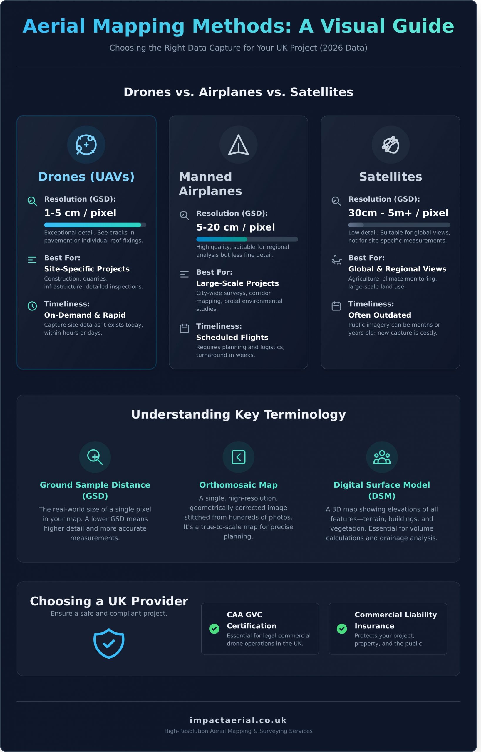
Key Terminology Explained: GSD, Orthomosaics, and DSMs
Understanding a few core terms is essential when commissioning an aerial survey. These concepts define the quality and utility of the final data products:
Ground Sample Distance (GSD): This is the real-world size of a single pixel in your map. A lower GSD means higher detail. For example, a 2cm GSD allows you to identify features as small as a minor crack in pavement or individual roof fixings.
Orthomosaic Map: This is a single, geometrically corrected image created by stitching all the individual photos together. It has a uniform scale, removing perspective distortion, and can be used as a true-to-scale base map for measurements and planning.
Digital Surface Models (DSM): A DSM is a 3D map that captures the elevation of the terrain and all surface features, including buildings, vegetation, machinery, and stockpiles. It is invaluable for volume calculations, line-of-sight analysis, and drainage planning.
High-Resolution Drone Maps vs. Google Maps: A Comparison
The difference between professionally captured drone data and freely available satellite imagery is significant. For commercial applications, these distinctions are critical:
Resolution: Drone maps offer a GSD measured in centimetres (typically 1-5cm per pixel). Satellite imagery is usually measured in metres per pixel. This is the difference between seeing a car and being able to read its license plate.
Timeliness: Drone surveys are conducted on-demand, providing a snapshot of your site as it exists today. Public satellite imagery can be months or even years out of date, failing to reflect current construction progress or site conditions.
Detail: The superior clarity of drone maps allows you to identify specific site assets, monitor safety hazards, assess roof conditions, or measure stockpile volumes with a high degree of precision-details completely lost in standard satellite views.
Aerial Mapping Methods: Drones vs. Airplanes vs. Satellites
When commissioning high resolution aerial mapping UK wide, the first critical decision is selecting the right data capture method. Not all aerial imagery is created equal, and the platform used to acquire it fundamentally dictates the quality, cost, and suitability for your project. The choice between drones, manned aircraft, and satellites depends entirely on your specific requirements for project size, accuracy, and budget. Understanding these differences ensures you invest in the right tool for the job.
Drone (UAV) Mapping: Precision and Flexibility
Unmanned Aerial Vehicles (UAVs), or drones, provide unparalleled detail for site-specific projects. They are the ideal solution for construction sites, quarries, individual property developments, and detailed asset inspections. By flying at lower altitudes, drones can achieve an exceptional Ground Sample Distance (GSD) of 1-5cm. This method is highly flexible, allowing for on-demand deployment that is extremely cost-effective for smaller, targeted areas and for capturing complex vertical details on structures.
For projects requiring coverage of entire cities, transport corridors, or counties, manned aircraft are the most efficient solution. This method is the backbone for national datasets, mapping vast areas in a single operation. It’s the approach used by large data providers to create the detailed imagery layers found in products like the Ordnance Survey MasterMap. The trade-off is typically a lower resolution (5-20cm GSD) and less frequent updates, often on an annual or bi-annual cycle, making it less suitable for monitoring rapid site changes.
Satellite Imagery: Global Scale, Lower Detail
Satellite imagery offers the broadest coverage, capable of capturing data on a national or even global scale. This makes it a valuable tool for large-scale environmental monitoring, agricultural analysis, or tracking weather systems over remote areas where other methods are impractical. However, its primary limitation for most commercial projects is its significantly lower resolution (typically 30cm GSD or more). Furthermore, operations are often hampered by cloud cover, a frequent challenge in the UK climate, which can obscure the area of interest.
The Professional Drone Mapping Process: From Plan to Product
Achieving survey-grade accuracy with high-resolution aerial mapping in the UK demands more than just a drone. It requires a meticulous, multi-stage process managed by certified professionals. This structured approach ensures every mission is safe, compliant with Civil Aviation Authority (CAA) regulations, and delivers the actionable data your business needs. It is this rigorous methodology that separates a professional data-gathering operation from a hobbyist flight, providing you with reliable results and complete peace of mind.
Step 1: Project Scoping and Safety Planning
Every successful mission begins on the ground. The first step is a detailed consultation to define your project’s specific goals, from the required Ground Sample Distance (GSD) to the final data formats you need. Following this, we conduct a comprehensive risk assessment and pre-flight survey. This crucial stage involves creating a strategic flight plan to guarantee 100% site coverage while operating in full compliance with all CAA operational authorisations, ensuring a safe and efficient data capture.
Step 2: On-Site Data Acquisition
With planning complete, our on-site team executes the flight mission with precision. For projects requiring the highest level of accuracy, we establish a network of Ground Control Points (GCPs), which are precisely measured coordinates that anchor the aerial data to the real world. Our CAA GVC Certified pilots then fly automated grid patterns using commercial-grade drones, capturing thousands of overlapping high-resolution images. This on-site precision is fundamental to professional high-resolution aerial mapping with UAVs, with our team constantly monitoring flight conditions and safety parameters throughout the operation.
Step 3: Data Processing and Deliverables
Once the raw data is captured, it is transferred to our powerful processing workstations. Using advanced photogrammetry software, the individual images are stitched together and georeferenced to create a seamless, accurate digital representation of your site. From this single dataset, we generate a suite of valuable outputs tailored to your needs.
Digital Surface/Terrain Models (DSM/DTM): Detailed elevation data for analysis.
3D Models & Point Clouds: Rich, interactive models for visualisation and measurement.
All deliverables are provided in industry-standard formats, ready for direct integration into your existing CAD or GIS software workflows.
Applications of High-Resolution Mapping Across UK Industries
Modern aerial maps are far more than just images; they are powerful data-gathering tools that deliver a significant return on investment across a diverse range of commercial sectors. The value lies in translating detailed, up-to-date imagery into actionable intelligence that enhances efficiency, improves safety, and reduces operational costs. For businesses across the country, professional high resolution aerial mapping uk services provide the critical data needed to make informed, strategic decisions with confidence.
Construction and Civil Engineering
On a dynamic construction site, accurate and timely information is paramount. High-resolution aerial data provides project managers with an unparalleled overview, enabling precise monitoring and management from project inception to completion.
Progress Monitoring: Conduct weekly or monthly flights to track site progress against architectural plans and schedules, providing clear evidence for stakeholder reports.
Volume Calculations: Accurately measure stockpile volumes of aggregates, soil, or waste, leading to precise inventory management and cost control.
Site Safety: Generate detailed terrain models (DTMs) and digital surface models (DSMs) to identify potential hazards, plan safe access routes, and ensure HSE compliance.
Property Development and Surveying
From marketing a new development to maintaining existing assets, aerial mapping offers a safe, fast, and cost-effective solution. It captures comprehensive data of buildings and land, supporting surveyors and developers throughout the property lifecycle.
Marketing Materials: Create compelling, high-quality aerial photographs and 3D models of properties and development sites that showcase them in the best possible light.
Condition Surveys: Safely inspect roofs, facades, and other hard-to-reach structures without the need for expensive scaffolding or access platforms, identifying defects early.
As-Built Surveys: Provide verifiable, accurate as-built data for planning applications, boundary disputes, and legal documentation, ensuring full compliance.
Agriculture and Environmental Management
The versatility of drone-captured data makes it an indispensable tool for managing vast areas of land and monitoring sensitive environments. This technology supports sustainable practices and provides crucial data for environmental impact assessments and conservation efforts.
Precision Agriculture: Use multispectral imagery to assess crop health, detect stress, and optimise the application of water and fertilisers, increasing yields and reducing waste.
Environmental Monitoring: Track land use changes, monitor habitat regeneration, or map the extent of flooding and soil erosion over time with repeatable, high-precision surveys.
Coastal and Habitat Mapping: Conduct detailed coastal erosion surveys or map delicate ecosystems with centimetre-level accuracy, providing essential data for conservation bodies and local authorities.
The applications are extensive, demonstrating how professional high resolution aerial mapping uk services can be tailored to meet the unique data requirements of any industry. To understand how our CAA GVC certified pilots can support your project, contact our team today.
How to Choose a UK Aerial Mapping Provider
Selecting the right partner is the single most critical decision for the success of your project. The quality, accuracy, and legal compliance of your data depend entirely on the operator you choose. When evaluating providers for high resolution aerial mapping UK services, it’s essential to look beyond a polished portfolio and scrutinise their professional credentials and operational standards. Arming yourself with the right questions will help you distinguish a truly professional operator from a hobbyist.
Non-Negotiable Credentials: Certification and Insurance
A professional provider will always be transparent about their qualifications. For your peace of mind and project security, ensure any potential partner holds a valid CAA GVC (General Visual Line of Sight Certificate), the legal requirement for commercial drone operations in the UK. Furthermore, they must have adequate commercial liability insurance; a minimum of £5m is the industry standard and protects you, your assets, and the public. Finally, ask for relevant case studies or client testimonials that demonstrate a proven track record in your sector.
Key Questions to Ask Your Provider
Before committing, a detailed discussion about your project’s technical requirements is vital. Use these questions to vet their expertise and ensure they can meet your specific needs:
What Ground Sample Distance (GSD) and absolute accuracy can you achieve for my project? This determines the level of detail and precision in the final data.
Do you use Ground Control Points (GCPs) for your surveys? For survey-grade accuracy, the use of GCPs is often essential.
What are your standard safety procedures and contingency plans? A professional operator will have robust risk assessments and emergency protocols.
In what formats will the final data be delivered? Ensure they can provide outputs compatible with your existing software (e.g., GeoTIFF, LAS, OBJ, DWG).
Why Impact Aerial is Your Trusted Partner
At Impact Aerial, we provide a professional, end-to-end service built on a foundation of safety, expertise, and cutting-edge technology. We are fully CAA GVC certified and hold £5m commercial liability insurance as standard. Our expert pilots utilise the latest DJI Enterprise drones to deliver superior data quality for every project. From initial flight planning and risk assessment to final data processing and delivery, we manage the entire workflow, ensuring you receive actionable, high-accuracy results you can rely on.
As we’ve explored, the landscape of project management and data analysis is being fundamentally transformed by aerial data. From the unparalleled detail captured by advanced drones to its diverse applications across UK industries, the benefits are undeniable. This makes choosing a professional partner for your high resolution aerial mapping uk project not just a preference, but a necessity for achieving accurate, reliable, and legally compliant results.
At Impact Aerial, we provide this essential combination of technical expertise and regulatory diligence. Our operations are conducted by fully CAA GVC Certified pilots and are covered by £5m commercial liability insurance for your complete peace of mind. As specialists in DJI Enterprise drone technology, we are equipped to deliver the top-quality data your project demands.
The accuracy of our high-resolution drone mapping is exceptionally high, often achieving survey-grade precision. Using advanced drones with RTK/PPK technology and strategically placed Ground Control Points (GCPs), we can deliver data with an absolute accuracy of down to 1-3cm. This level of detail is critical for applications in construction, land surveying, and asset management, ensuring you receive reliable and actionable data for your project.
What does a typical aerial mapping project cost in the UK?
The cost for a high resolution aerial mapping uk project typically starts from £500 for a small, straightforward site. The final price is dependent on factors such as the total area, site complexity, access restrictions, and the specific data deliverables required, like 3D models or detailed orthomosaics. We provide a detailed, fixed-price quotation following our initial project consultation to ensure complete transparency and for your added peace of mind.
How long does it take to map a site and receive the data?
The on-site data capture for a standard site of up to 20 hectares can often be completed within a few hours. Following the flight, our team undertakes rigorous data processing and quality assurance. You can typically expect to receive the finalised high-resolution maps, models, and reports within 3-5 business days. We will always provide a clear project timeline from the outset, keeping you informed at every stage of the process.
What is the maximum area you can map with a drone?
While there is no theoretical maximum area, operational logistics determine what can be covered in a single day. A single flight team can typically map between 50 and 100 hectares per day, depending on the site’s shape and terrain. For larger projects spanning hundreds or thousands of hectares, we develop a phased flight plan over multiple days, ensuring consistent data quality and full compliance with all CAA (Civil Aviation Authority) regulations.
Are your drone mapping services available across the entire UK?
Yes, our professional services are available across the entire United Kingdom. Our CAA GVC Certified pilots are equipped to operate nationwide, including in England, Scotland, Wales, and Northern Ireland. While we are based in the Midlands, we regularly undertake projects from Cornwall to the Scottish Highlands. Projects located further from our base may include pre-agreed travel and accommodation costs, which will be clearly itemised in your quotation.
What happens if the weather is bad on the scheduled flight day?
Client and public safety is our highest priority, and we operate in strict accordance with CAA safety regulations. We cannot fly in rain, high winds, or other adverse weather conditions. Our team constantly monitors the forecast in the days leading up to a scheduled flight. If the weather is deemed unsuitable, we will liaise with you to reschedule the operation for the next suitable day at no additional cost to you.