
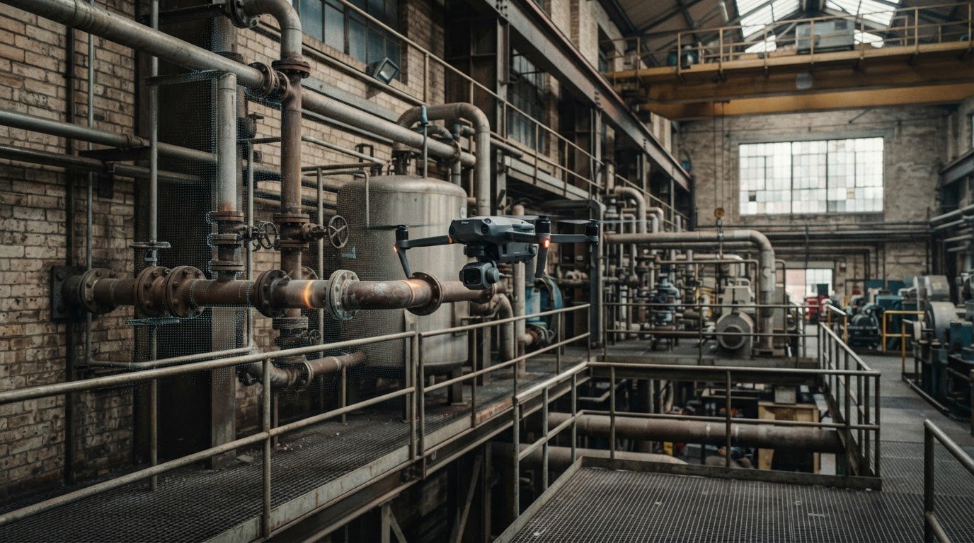
A scaffold is not always the first option for inspecting a hard-to-reach plant asset. Aerial inspection for manufacturing plants uses drones to capture close-up visual imagery. Thermal imaging can add information about temperature patterns, while LiDAR can provide a three-dimensional view of structures. Aerial images help teams examine elevated or obstructed areas and plan follow-up maintenance using clearer visual evidence.
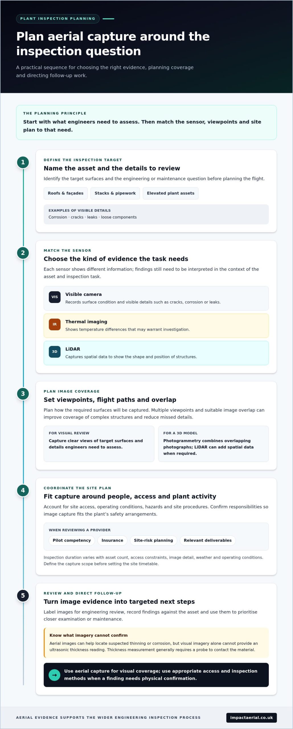
The aircraft matters, but so do the sensor and capture plan. A standard camera records visible surface conditions; thermal imaging shows temperature differences that may warrant investigation; LiDAR maps shape and position. Each provides different information, and none removes the need to interpret findings in the context of the asset and inspection task.
This guide explains which plant assets can be inspected from the air, how camera, thermal and LiDAR data differ, and what teams should consider when planning useful image capture. It also covers practical limits, including visibility, access, operating conditions and coordination with site procedures, to help you decide where an aerial survey fits into your inspection programme.
Key Takeaways
- Match the sensor to the inspection question: visible cameras record surface condition, thermal imaging highlights temperature differences, and LiDAR captures structural geometry.
- Define the asset and the details engineers need to assess before planning flight paths and image capture.
- Use multiple viewpoints and suitable image overlap to improve coverage of complex structures and reduce missed details.
- Coordinate site access, operating activity and personnel responsibilities so image capture fits the plant’s safety procedures.
- Use aerial surveys to inform targeted maintenance, while treating image interpretation as part of the wider engineering inspection process.
Aerial drone inspection of elevated industrial assets
For elevated plant assets, a drone can capture visual evidence from viewpoints that are difficult to reach from the ground. The images are most useful when they address a specific maintenance or engineering question.
Manufacturing Facility Drone Inspections
A manufacturing facility drone inspection uses an aircraft-mounted camera to record roofs, façades, stacks, pipework and other elevated assets. Before the flight, the team identifies the target surfaces and details engineers need to review, such as corrosion, cracks, leaks or loose components. Consistent visual records help maintenance teams prioritise closer examination. For example, an image of a roof seam can help pinpoint an area for follow-up assessment.
Inspection Benefits and Limitations
Aerial inspection provides close-range, multi-angle views without placing an inspector on the structure. Conventional access, by contrast, can support hands-on checks and direct measurement. Drone images help engineers identify visible defects and target subsequent work, but cannot establish every material condition or replace specialist testing. The choice depends on the task: use aerial capture for visual coverage, then appropriate access and inspection methods when a finding needs physical confirmation.
Choosing a Provider and Planning Inspection Time
When choosing a provider, review pilot competency, insurance, site-risk planning and examples of deliverables for similar assets. For industrial facilities evaluating specialized drone survey expertise in the US, tdbsolutions.ai illustrates how extensive survey experience shapes precise capture plans and dependable inspection data. Ask how the flight plan will capture the required surfaces, manage hazards and account for plant activity, and how images will be labelled for engineering review. There is no fixed duration for a manufacturing plant inspection: asset count, access constraints, image detail, weather and operating conditions all affect scheduling. Define the capture scope before setting a site timetable.
For power lines and utility poles, drones can capture close-range views from multiple angles, helping inspectors examine conductors, fittings and pole-mounted equipment. A planned route should provide enough visual coverage to compare components and flag areas for closer assessment. This supports inspection planning, but the images still need to be interpreted alongside the asset’s condition and maintenance history.
Telecommunications tower inspections use high-resolution cameras to examine tower sections, mounting devices and visible rust or corrosion. Images can document fittings at height and help maintenance teams plan repairs before deterioration progresses. For a tower upgrade, repeatable views can also give engineers a shared visual record of the structure and its equipment.
Industrial drone ultrasonic thickness testing differs from camera inspection: ultrasonic thickness measurement generally requires a probe to contact the material. A drone camera can help locate and document suspected thinning or corrosion, but visual imagery alone cannot provide a thickness reading. Teams can use aerial images to direct follow-up testing, then apply an appropriate contact method at the selected inspection points.
Inspection of hazardous or difficult-to-access assets
Drone inspection can document hazardous infrastructure while keeping personnel away from exposed surfaces. Examples include visibly damaged roofs, elevated pipework, pumping stations with suspected leaks and structures where access equipment could obstruct production. Before capture, the inspection plan should identify each target, the required viewing angles and operating constraints. This provides useful records without treating aerial imagery as a substitute for every physical test.
External open-rotor drones suit many outdoor inspections, including roof edges, stacks and pipeline routes. They can capture visible evidence of cracks, leaks, corrosion, loose components and surrounding conditions that may affect an asset. Internal tanks and vessels can present distinct inspection challenges, so the aircraft should be selected for the enclosed environment and its obstacles. The platform should suit the location, not just the asset type.
Three-dimensional asset models can help teams understand the position and shape of infrastructure that is difficult to inspect from one viewpoint. Photogrammetry combines overlapping photographs to create a measurable model; LiDAR can add spatial data where the survey requires it. Engineers can use a model to locate a defect, compare areas and coordinate maintenance or turnaround work. A chemical manufacturer observed operational improvements of up to 30% using digital twins to map and coordinate asset inspection and turnaround activities.
A digital twin connects asset information and inspection records to a changing representation of a facility. Teams can monitor known defects, compare later observations and relate findings to maintenance history. For example, a mapped pipe support can show engineers where a recorded condition sits within a wider process area. The model is most useful when asset labels, dates and inspection findings remain consistent over time.
Inspection images and data are analysed by sorting them against asset identifiers, reviewing visible conditions and recording findings to support maintenance priorities. To protect records, organisations should use approved storage, restrict access to authorised personnel and follow their own retention and data-handling procedures. Engineers can then link a marked image or model location to a work order, further examination or planned repair.
Choose the capture platform and analysis method around the hazard, required evidence and intended maintenance decision. For building exteriors and roofs, aerial survey imagery can help document visible condition and direct follow-up work. For enclosed vessels, contact-based measurements or specialist internal inspection methods may be needed alongside external aerial records.
Aerial imagery, LiDAR and thermal sensors
Sensor choice depends on the defects engineers need to find and the structures under inspection. A visual camera records surface details such as cracked coatings, loose fixings or visible corrosion. Thermal imaging records infrared patterns that can highlight differences not apparent in standard photographs. LiDAR captures spatial measurements for three-dimensional views of complex plant layouts. Since each sensor provides different evidence, define the maintenance question before selecting equipment.
High-resolution visible imagery helps engineers review roofs, façades, pipework and machinery from multiple angles. They can zoom in on a recorded image, compare nearby components and identify locations for closer assessment. However, a photograph shows visible condition, not internal material integrity. For example, an image may record coating damage, while further testing determines whether the underlying structure needs repair. Camera resolution and distance from the asset affect how clearly small features appear.
Thermal sensors add information about temperature patterns across equipment and structures. In photovoltaic inspections, infrared imagery can highlight defects across operating panels, while visible-light images help locate the affected module. For meaningful aerial infrared capture, the PV plant should operate at MPPT, reach electrical and thermal steady state, and be free of partial shading. Checking for soiling and cleaning the plant beforehand also helps produce interpretable results.
Survey speed depends on the aircraft, sensor, site and inspection scope. Aircraft-mounted infrared imagery can inspect 100-150 MW of PV capacity per hour; UAV or drone infrared imagery can inspect approximately 12 MW per day, or about 3 MW per hour. These figures describe different capture methods and capacities, not a guaranteed inspection duration for every site. Plant layout, image detail and operating conditions affect the mission plan.
LiDAR measures distances to create a point cloud representing the shape and position of structures. Engineers can use this spatial record to examine clearances, map pipe routes or support a three-dimensional asset model. Combining LiDAR with visual imagery can link geometry to visible surface condition. This is useful in congested process areas where ground-level photographs make it difficult to understand how platforms, ducts and nearby equipment relate to one another.
For photovoltaic infrared procedures, IEC TC82 released IEC TS 62446-3 in 2017. It covers infrared inspection procedures and requirements. That reference helps frame a repeatable method for solar surveys, but the sensor still needs a suitable capture plan and operating conditions. For other hazardous environments, teams should match sensor capability to the intended analysis: visible imagery for surface evidence, thermal data for temperature patterns, and LiDAR for spatial form.
Camera field of view and inspection coverage
A camera’s field of view determines how much of an asset appears in each image. A wider view captures more of the structure, while a closer view can reveal smaller surface defects. Inspection planning balances coverage and detail: a distant image may show an entire platform but miss fine corrosion, while a close-up may lack surrounding context. The mission should capture both where engineers need them.
One inspection study used an average camera focal length of 30 mm in its calculations. At the application scale, it calculated an approximate field of view of 400 mm by 250 mm. These figures describe that study’s setup, not a universal camera specification. Actual coverage changes with camera, lens, distance and angle, so engineers need to relate the image footprint to the asset’s size.
Overlap between adjacent images helps provide continuous coverage and supports image alignment. The simulated inspection profile in the study used 30% overlap between neighbouring pictures. With overlap, a crack or corroded joint near an image edge is more likely to appear in the next frame. This also gives processing software shared visual features for combining photographs into a larger record or model.
Before planning the flight path, divide the plant structure into surfaces. A vertical vessel may need separate passes for its upper shell, lower shell, attachments and support points. Pipework may need views along its route and around bends, where brackets or nearby equipment can obscure defects. Recording the intended viewpoints helps the team identify gaps and create a clearer visual inspection record.
Distance and orientation affect how clearly a feature can be assessed. A camera angled sharply across a surface may distort its appearance or hide damage behind a flange. A more perpendicular viewpoint can show a joint or coating defect more clearly. Engineers should specify the smallest relevant feature and the surfaces that matter, then set camera positions and image overlap to match those priorities.
Coverage is not simply a matter of how many pictures are captured. A large collection can still contain blind spots if images lack consistent viewpoints or asset references. Label each group by structure, surface and direction, then compare planned coverage with the captured images. An engineer reviewing a corrosion mark, for example, needs its location on the asset, a clear view of its edges and enough surrounding context to plan follow-up work.
Before the mission, align the camera plan with the inspection purpose, asset drawings and access constraints. Adjust the route if shadows, obstructions or reflective surfaces affect image clarity. After capture, check coverage against the planned areas and flag missing views for another pass when conditions allow. This focuses effort on useful evidence and reduces incomplete records without treating imagery as a replacement for other required inspection methods.
Planning safe image-data capture with company personnel and engineers
A useful plant inspection starts with a shared brief, not a flight path. Company personnel identify the assets, operating constraints and areas that must remain clear. Engineers define the conditions they need to assess, such as a damaged roof panel or leaking pipe joint. The pilot then plans image capture around those requirements and the site’s hazards.
In the UK, industrial drone flights must comply with applicable Civil Aviation Authority requirements. Permissions and operating conditions depend on the proposed flight, aircraft and location, including nearby people and site constraints. A CAA-GVC Certified pilot has completed recognised competency training, but each flight still needs planning for its specific environment and purpose.
Before the mission, agree who is responsible for each part of the work. The site representative can brief the flight team on access, active production areas, vehicle routes and restricted zones. The pilot can explain the proposed flight boundary, launch location and conditions that would pause capture. Engineers can identify asset labels and viewpoints so the imagery links clearly to maintenance records.
- Define the deliverable: agree whether engineers need overview images, close-up defect records, thermal data or a mapped model.
- Identify site interfaces: mark people, moving equipment, overhead obstructions and areas where flight must not proceed.
- Set communication points: establish how the pilot and site contact will report changes during capture.
- Plan data handling: agree file names, asset references, access controls and the intended recipients.
These steps help personnel respond if production activity changes or an unexpected hazard arises. An autonomous flight plan may repeat a route consistently, but automation does not remove the need for oversight. A trained pilot should retain control of the operation and adapt or stop capture if conditions differ from the agreed plan. Engineers can then distinguish planned coverage from areas missed because of a safety constraint.
Image-data planning also affects the usefulness of inspection records. For example, linking a close-up of a corroded support to its asset identifier helps engineers locate the finding without relying on memory. A dated, clearly labelled record can be compared with later observations and used to prioritise further examination. Agreeing these conventions before the flight helps ensure the files fit existing engineering workflows.
For a commercial building or plant exterior, a drone commercial property survey can provide organised aerial imagery for condition review. Define the inspection question, site interfaces and required outputs together, so the capture plan serves both safe operations and engineering analysis.
Impact Aerial: Aerial Filming and Photography
Impact Aerial provides Aerial Filming and Photography for organisations that need clear aerial imagery of sites, structures or projects. Its commercial drones use 4K HDR cameras, producing detailed visual material that can support site records and project communication. For engineering inspections, agree the required viewpoints and outputs so captured imagery serves the intended review, while technical findings remain for qualified engineering assessment.
For solar assets or commercial property, PV Solar Farm Thermal Surveys and Drone Commercial Property Surveys are more directly suited to the inspection. Construction Site Monitoring can support visual records of project progress. The right option depends on the assets and information your team needs to capture.
To discuss aerial imagery for your site, contact Impact Aerial or visit impactaerial.co.uk.
Turn inspection findings into a clear next step
The value of aerial inspection for manufacturing plants depends on what happens after image capture. Use the findings to identify priority assets, assign follow-up checks and establish consistent viewpoints for future comparisons. A concise inspection brief that clearly defines the assets and decisions gives your team a practical starting point for planning its next survey.
Impact Aerial offers Aerial Filming and Photography for visual documentation, PV Solar Farm Thermal Surveys for solar assets, and Drone Commercial Property Surveys for building exteriors. Each service suits different inspection needs. The next step is to match the aerial work to the assets and information your team requires.
Contact Impact Aerial to discuss inspection and outline the site, assets and intended use of the imagery. A well-defined brief can help your team move from an inspection question towards an informed maintenance plan.
Frequently Asked Questions
What is aerial inspection for manufacturing plants?
Aerial inspection for manufacturing plants uses a drone to collect images or sensor data about site assets. Engineers use the resulting records to identify areas that need maintenance or closer examination. For example, a team might document a roof after a storm and compare affected sections with maintenance records. It is a visual assessment method, not a substitute for hands-on testing when measurements or material checks are required.
What types of drones and sensors are used for factory inspections?
Factory inspections commonly use commercial multirotor drones for controlled movement around structures, paired with sensors selected for the task. A high-resolution camera records visible conditions; thermal imaging captures temperature patterns; LiDAR collects spatial data for mapping. Some enclosed spaces require specialised caged, collision-tolerant aircraft. Choose equipment according to the location, evidence required and operating environment, rather than assuming one aircraft or sensor suits every inspection.
What parts of a manufacturing plant can be inspected by drone?
Drones can capture views of accessible exterior assets, including roofs, façades, stacks, elevated pipework, tanks, towers and utility connections. Coverage depends on obstructions and safe flight conditions. For example, a roof survey can document visible damage around vents and drainage features, while views of an external pipe route can help locate areas for closer review. Internal vessels require equipment suited to confined, enclosed environments.
What health and safety precautions are needed for drone inspections inside and around factories?
Plan the flight with the site safety lead, identifying people, vehicle routes, overhead hazards and restricted areas. Agree on a launch location, flight boundary, communication method and stop-work conditions before capture. For indoor work, assess confined spaces, moving equipment and any hazardous atmosphere, and use aircraft and procedures suited to those conditions. Keep the flight within the agreed plan and pause if plant activity or site conditions change.
What are the risks of using drones near workers, machinery and power lines?
Near workers, a drone can cause injury through contact or distraction; near machinery, it may collide with moving equipment or become caught. Power lines pose collision and electrical hazards, while metal structures and operating equipment can complicate control or visibility. A site-specific assessment should identify these risks, set an exclusion area, coordinate with operations staff and define when the pilot must hold position, land or stop.
What steps are involved in planning and carrying out a factory aerial inspection?
Start by defining the inspection question and assets, then agree site access, hazards and operating constraints with the relevant personnel. The pilot plans the route and capture requirements, completes the agreed safety checks and carries out the flight under the site plan. After capture, organise images by asset and location, review coverage and share relevant findings with engineers. They can use the records to prioritise follow-up checks or maintenance.
 2 Norton Drive, Wythall, Birmingham, B47 6HH Company registration number: 11138586. VAT Number: 366 9068 55


