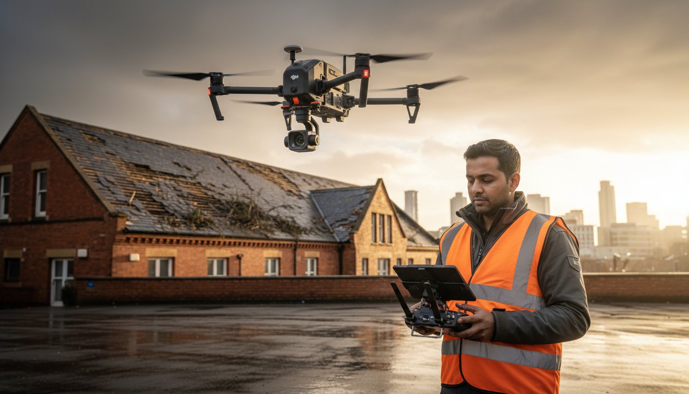
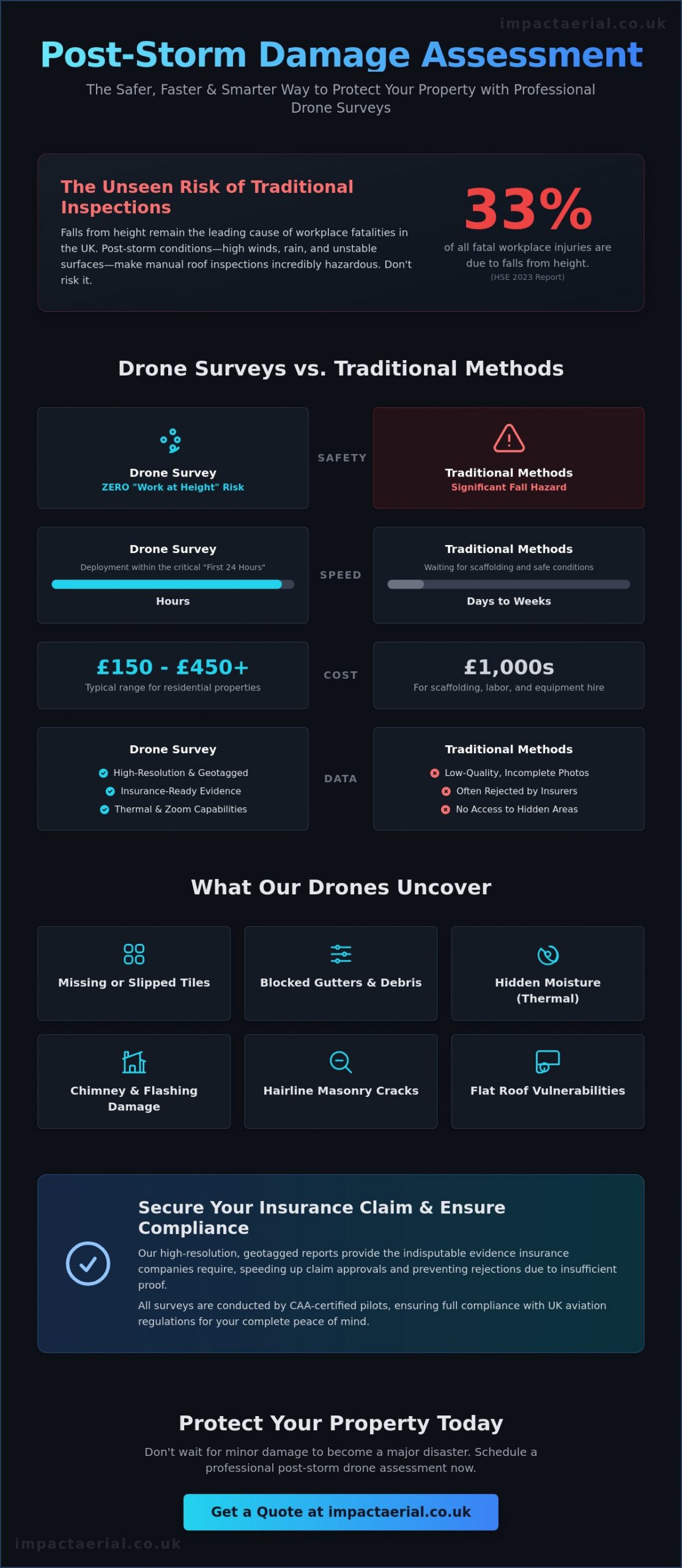
Falls from height remain the leading cause of workplace fatalities in the UK, accounting for 33% of all fatal injuries according to the Health and Safety Executive (HSE) 2023 report. When high winds and heavy rain batter your property, the urge to inspect the roof immediately is strong, yet manual climbing in post-storm conditions is a risk you don’t need to take. Utilizing a professional post-storm damage assessment drone offers a sophisticated, ground-based solution that captures high-resolution evidence without putting lives at stake.
You’re likely worried about water ingress causing further building degradation while you wait weeks for a traditional roofing contractor to arrive with scaffolding. We understand that the race against the elements is stressful, especially when insurance companies frequently reject low-quality or incomplete evidence. This guide explains how professional drone surveys provide the high-resolution, geotagged proof required for rapid recovery. You’ll discover how the January 1, 2026 CAA regulations ensure operational safety and why a drone inspection, often starting between £150 and £450 for residential properties, is the most cost-effective way to secure your insurance claim and your peace of mind.
Key Takeaways
- Learn why the “First 24 Hours” rule is critical for capturing aerial data to prevent secondary water damage and building degradation.
- Discover how a professional post-storm damage assessment drone eliminates “Work at Height” risks while providing a cost-effective alternative to scaffolding.
- Understand the essential role of high-resolution, geotagged evidence in securing insurance claim approval and speeding up loss adjustment turnaround.
- Identify how specialized DJI Enterprise drones detect subtle structural issues like slipped slates and guttering blockages across complex commercial roof spans.
- Explore the regulatory requirements for CAA-compliant surveys that provide the necessary peace of mind and technical precision for property recovery.
What is a Post-Storm Damage Assessment Drone Survey?
A post-storm damage assessment drone survey is a methodical, high-resolution aerial inspection designed to identify structural and cosmetic compromises following severe weather events. Unlike a cursory visual check from the ground, this specialized service utilizes commercial-grade UAVs to capture every inch of a building’s exterior. It’s an essential component of modern drone applications in disaster relief and property maintenance, providing property owners with insurance-ready data within hours of a storm passing. This process transforms a dangerous manual task into a precise, data-driven operation.
The “First 24 Hours” rule is a standard we uphold because immediate data collection is the only way to prevent secondary water damage. If a tile is displaced or a gutter is blocked by debris, water can penetrate the building envelope immediately. By deploying a post-storm damage assessment drone quickly, we identify these vulnerabilities before they escalate into catastrophic internal degradation or mold growth. Our scope of work is comprehensive, covering everything from intricate residential roof tiles to expansive commercial warehouse guttering systems. We provide a level of detail that ground-based photography simply can’t match.
To better understand how aerial technology is revolutionizing this field, watch this helpful video:
Professional surveys differ significantly from a “quick look” provided by a hobbyist. We focus on rigorous data-gathering, ensuring every image is geotagged and timestamped for legal and insurance purposes. This meticulousness is what separates a professional service from a casual flight. We don’t just take pictures; we create a technical record of your property’s condition that stands up to the scrutiny of loss adjusters and structural engineers.
The Technology Behind the Inspection
Precision requires the right tools. Our fleet utilizes 4K HDR imagery to detect hairline cracks in masonry that are invisible to the naked eye. For commercial properties, we often use thermal imaging to identify hidden moisture pockets trapped beneath roof membranes, which signal long-term structural risks. High-zoom capabilities allow us to inspect precarious chimneys and high-level architectural features from a safe distance, maintaining strict safety protocols while delivering 100% visual coverage of the asset.
Why Traditional Methods Fail After a Storm
Traditional inspections are often too slow and too dangerous. Safety risks are paramount; using ladders on saturated or unstable ground after a storm is a significant hazard. Scaffolding presents a massive bottleneck because waiting for equipment to be delivered and erected can take days or weeks. During this delay, your building remains exposed to further damage. Additionally, ground-based photography misses approximately 70% of roof-level issues because the angle of incidence is too shallow to see into valleys or behind parapet walls. Aerial surveys eliminate these blind spots entirely.
Common Types of Storm Damage Identified by Drones
High winds and torrential rain leave a trail of destruction that’s often invisible from the street. Our post-storm damage assessment drone surveys systematically document these issues, providing a comprehensive audit of the building envelope. We look for missing or slipped tiles across large roof spans, which are prime entry points for moisture. Even a single displaced slate can lead to significant interior damage if left unaddressed. Precision is vital here; our high-resolution sensors capture the specific condition of every fastener and overlap.
Debris from nearby trees frequently blocks guttering systems, leading to “overspill” and foundation saturation. Drones identify these blockages and sediment build-up instantly. We also evaluate chimney stack stability and the integrity of lead flashing. High-resolution imagery reveals cracks in mortar or loose leadwork that would otherwise require a cherry picker to inspect. For commercial properties, we focus on flat roof vulnerabilities. We detect “ponding,” where water pools due to structural deflection, and identify tears in the waterproof membrane. These issues are common after heavy UK storms and often lead to costly inventory damage.
Roof and Structural Integrity
Ridge tiles are a specific concern. If they’re loose, they represent a significant falling hazard to the public and property. We also assess impact damage from wind-blown debris or fallen branches that can crack structural members. Photogrammetry allows us to process multiple aerial images to create a highly accurate 3D model that highlights subtle structural shifts or warping in the roofline. Deploying a post-storm damage assessment drone ensures these risks are documented safely and accurately before repairs begin.
Solar PV and Ancillary Equipment
Storms don’t just damage the structure; they impact expensive technology. We utilize thermal camera drones to identify micro-cracks in solar cells that are invisible to the eye but cause significant power loss. Our pilots also check HVAC units and aerials for wind-induced misalignment. Hail or high-velocity winds can compromise skylights and roof lanterns, so we verify their seals and glass integrity to ensure the building remains watertight. If you require a detailed report on these assets, our professional aerial inspections provide the necessary clarity for your maintenance team.
Drone Surveys vs. Traditional Scaffolding: Cost and Safety
Choosing between a professional post-storm damage assessment drone and traditional scaffolding isn’t just about technology; it’s a strategic decision that affects your liability, budget, and recovery timeline. Traditional methods require physical access to the roofline, often involving ladders or cherry pickers on ground that may be saturated or unstable following a storm. In contrast, drone surveys provide a remote sensing solution that captures the entire asset from every elevation without a single person leaving the ground. This comprehensive data collection ensures that no “blind spots” remain, which is a common failure point in manual inspections that only focus on one easily accessible side of a building.
Speed of deployment is where the drone truly outshines traditional access equipment. While a scaffolding firm might take several days to deliver and erect a structure, a drone survey can be completed in just a few hours. This rapid response is vital for preventing water ingress from escalating into structural rot. By identifying issues early, property managers can move from assessment to repair while the scaffolding teams are still drafting their initial quotes.
The Safety Advantage
Safety is our primary operational priority. Falls from height account for 33% of all fatal workplace injuries in the UK according to 2023 HSE statistics. By eliminating the need for “Work at Height” during the initial assessment phase, we significantly reduce the liability for property owners and managers. This is why meticulous risk assessments and CAA-compliant flight plans are central to our drone services in the UK. We operate within the critical “post-storm window,” providing high-resolution data even when ground conditions are too poor for heavy machinery or manual climbing.
Cost Comparison and ROI
The financial argument for aerial surveys is compelling. A post-storm damage assessment drone survey is typically 30% to 70% cheaper than traditional methods like scaffolding or cherry picker hire. These direct cost savings are bolstered by indirect benefits, such as preventing business downtime through faster underwriting and claim processing. Industry data from May 2026 indicates that insurers using drone data can speed up inspection turnaround by 40%. Investing in high-quality data from survey drones ensures asset longevity by catching minor leaks before they necessitate thousands of pounds in long-term structural repairs. It’s a proactive approach that prioritizes precision over expensive, outdated access solutions.
Navigating Insurance Claims and CAA Compliance
Insurance adjusters prioritize objective, irrefutable data when evaluating a claim. A professional post-storm damage assessment drone provides exactly this through high-resolution imagery paired with meticulous timestamped and geotagged metadata. This level of technical detail eliminates the ambiguity often found in handheld smartphone photos or ground-based visual inspections. Every pixel in our data-gathering process is tied to a specific GPS coordinate, proving that the damage occurred at your property during the reported weather event. This precision reduces the likelihood of claim rejection and helps loss adjusters validate the scope of repairs quickly.
Hiring a CAA GVC certified pilot is a legal and financial necessity. As of May 2026, insurance companies are increasingly scrutinizing the credentials of surveyors before accepting their reports. If a survey is conducted by an unlicensed operator or someone without valid commercial liability insurance, the resulting evidence may be deemed inadmissible. We maintain £5m in commercial liability insurance as an industry benchmark, providing the necessary peace of mind for commercial property owners and stakeholders during the recovery phase.
Preparing Your Insurance Dossier
A robust insurance dossier should include before-and-after comparisons and extreme close-up crops of specific defects like hairline cracks or missing fasteners. While high-resolution stills provide the raw data, aerial filming drones offer a cinematic overview that helps adjusters understand the full context and scale of the site damage. Professional reports that synthesize these visual elements into a structured format significantly accelerate the claim approval process by reducing the need for multiple follow-up site visits. We provide the technical evidence adjusters need to release funds for repairs without delay.
Understanding UK Drone Regulations
Operating in congested urban environments like Birmingham and the West Midlands requires precise flight planning and strict adherence to the latest CAA rules. We manage complex flight paths and ensure full compliance with GDPR and privacy laws to protect neighbouring properties. The transition from the old PfCO to the current GVC (General Visual Line of Sight Certificate) is a critical distinction in 2026. This modern qualification demonstrates that the pilot is trained in the latest safety protocols and risk management techniques. All our operations also comply with the January 1, 2026 Remote ID requirements, ensuring every flight is legal and traceable. If you need an insurance-ready audit for your property, book a professional drone survey today.
Impact Aerial: Professional Post-Storm Drone Services
Based in Birmingham, Impact Aerial provides a rapid response for property owners and managers across the West Midlands. Our strategic location allows us to deploy to sites within hours of a major weather event, ensuring that data collection begins before secondary damage takes hold. We utilize a fleet of the latest DJI Enterprise commercial drones, which offer superior wind resistance and 4K HDR image clarity. These technical specifications are vital when flying in the turbulent air often found around urban structures following a storm. Every flight we conduct is backed by £5m in commercial liability insurance, ensuring that our clients are protected while we gather the high-resolution evidence needed for their recovery.
Our end-to-end service encompasses everything from the initial flight plan to post-production reporting and technical analysis. We don’t just hand over raw files. We provide structured data-gathering that highlights specific areas of concern for your maintenance team. This methodical approach is why we are a trusted partner for commercial property developers and building services managers throughout the region. Deploying a post-storm damage assessment drone with Impact Aerial ensures that your property audit is conducted with the highest level of precision and technological adeptness.
Why Choose Impact Aerial?
Meticulous safety standards are the foundation of our operations. We maintain CAA GVC certification as a standard requirement for all our pilots, ensuring we are fully compliant with the latest UK drone laws enacted on January 1, 2026. Our extensive experience across the property, construction, and building services sectors allows us to identify structural vulnerabilities that generic operators might overlook. We prioritize a client-focused approach, aiming to provide added peace of mind during what is often a stressful and time-sensitive recovery period. By choosing a specialized technical consultant rather than a creative agency, you ensure that your post-storm damage assessment drone survey meets the rigorous standards required by structural engineers and insurance adjusters alike.
Book Your Assessment
Requesting a rapid response survey is a straightforward process designed to get your recovery moving immediately. To initiate a survey, we require the site location, the type of building, and any specific areas where you suspect damage, such as localized leaks or visible debris. This information allows our team to conduct a preliminary risk assessment and prepare a flight plan that maximizes data quality while adhering to all safety regulations. Once the survey is complete, our post-production team processes the imagery into a comprehensive, insurance-ready report. Contact Impact Aerial today for a professional post-storm damage assessment.
Take Decisive Action for Property Recovery
Rapid recovery after a severe weather event depends on the quality of your data and the speed of your response. Utilizing a professional post-storm damage assessment drone allows you to document structural issues immediately, preventing water ingress from turning into long-term building degradation. This digital approach provides a level of detail that ground-based photography cannot match, ensuring every slipped tile and blocked gutter is recorded for your insurance dossier.
Impact Aerial stands ready to support property managers across Birmingham and the West Midlands with meticulous aerial surveys. Our pilots are CAA GVC Certified and backed by £5m commercial liability insurance, providing the technical precision and peace of mind your business requires. Don’t let your claim be delayed by inadequate evidence or the bottlenecks of traditional scaffolding hire. Secure your building and your insurance claim with a professional drone survey from Impact Aerial. We’re here to help you move from assessment to repair with confidence.
Frequently Asked Questions
Is drone footage accepted by UK insurance companies for storm damage?
Yes, UK insurance companies widely accept drone footage for claims. Using professional aerial data can reduce loss adjustment expenses by 30% and speed up the claims process significantly. Since insurers can process 1.5 times more claims per day with this technology, providing high-resolution, geotagged imagery from a post-storm damage assessment drone often leads to faster claim approvals and more accurate settlements.
How much does a post-storm drone survey cost compared to scaffolding?
Drone surveys are typically 30% to 70% cheaper than traditional scaffolding. A standard residential drone inspection in 2026 costs between £150 and £450 plus VAT, while commercial surveys generally start from £300 to £500. Scaffolding requires significant labor for assembly and multi-week rental fees, making it a much more expensive and slower option for initial damage assessments.
Can drones fly in high winds to assess damage immediately after a storm?
Commercial drones have strict wind speed limits to ensure operational safety. While our DJI Enterprise fleet offers superior wind resistance, we don’t fly during active gales that exceed manufacturer safety thresholds. We monitor weather patterns to deploy during the first safe window after a storm, ensuring we capture stable, high-resolution imagery without risking the property or public safety.
Do I need to notify my neighbours before a drone survey takes place?
We manage all privacy and neighbour notifications as part of our methodical flight planning process. Under UK GDPR and CAA regulations, we must ensure that neighbouring properties are not the focus of our data-gathering. Our pilots conduct thorough site assessments to maintain privacy, and we can use specialized software to mask non-target areas in the final report for added peace of mind.
What is the difference between a roof survey and a full structural drone inspection?
A roof survey focuses on tiles, flashing, and gutters, while a structural inspection evaluates the building’s overall integrity. We use a post-storm damage assessment drone to perform photogrammetry, creating 3D models that reveal structural shifts or warping. This advanced analysis is essential for commercial warehouses or heritage buildings that may have moved during high-velocity wind events.
How quickly can Impact Aerial deploy a drone after a severe weather event?
Impact Aerial aims to deploy within 24 to 48 hours of a storm passing through Birmingham or the West Midlands. Rapid response is vital to meet the “First 24 Hours” rule for preventing secondary water damage. Our local expertise allows us to navigate regional flight paths quickly, providing the technical evidence you need to start the repair process without delay.
What qualifications should a professional drone pilot have in 2026?
Professional pilots in 2026 must hold a CAA GVC (General Visual Line of Sight Certificate) and have a valid Operational Authorisation. Legally, they must also carry third-party liability insurance that complies with Regulation (EC) 785/2004. Additionally, all drones must broadcast Remote ID and carry a UK class mark to meet the newest safety standards effective from January 1, 2026.
Can drones detect leaks that are not visible to the naked eye?
Yes, drones equipped with thermal sensors detect moisture that is invisible to the eye. By identifying temperature variances on a roof’s surface, we find damp spots where water has penetrated the membrane but hasn’t yet reached the interior ceiling. This early detection prevents catastrophic building degradation and allows for targeted repairs rather than an expensive, full roof replacement.
