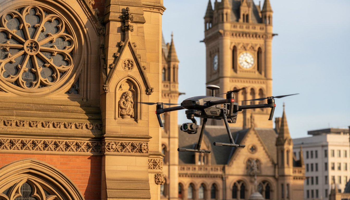
For centuries, the only way to truly understand the condition of a cathedral spire or a Tudor chimney was to spend thousands on scaffolding and hope the installation didn’t crack the very stone it was meant to protect. You’re likely aware that traditional high-level surveys are a logistical nightmare. The lead times are long, the costs are prohibitive, and ground-level visual inspections simply cannot capture the granularity required for precise conservation. A professional drone inspection for heritage buildings offers a superior, non-invasive alternative that secures high-resolution data without risking the historic fabric of the structure.
In this guide, you’ll discover how specialized aerial technology provides a cost-effective maintenance roadmap while ensuring full compliance with the latest CAA regulations and English Heritage protocols. We’ll explore the transition to UK-specific drone classifications effective as of January 2026 and examine how multi-sensor payloads, including thermal and LiDAR, are creating accurate digital twins. From identifying moisture ingress to automating defect detection with AI, this article covers everything you need to know about modernizing your heritage conservation strategy through meticulous, data-driven aerial surveys.
Key Takeaways
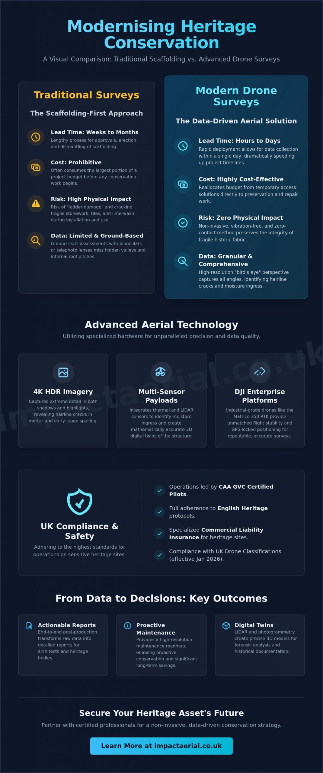
- Learn how switching from traditional scaffolding to aerial surveys can reduce lead times from weeks to hours while eliminating the risk of physical damage to historic stonework.
- Understand how 4K HDR imagery and DJI Enterprise technology identify critical defects, such as hairline cracks in lime mortar, that ground-level inspections often miss.
- Gain clarity on essential UK compliance standards, including the requirement for CAA GVC certified pilots and the necessity of specialized commercial liability insurance for sensitive sites.
- Discover how a professional drone inspection for heritage buildings provides a high-resolution maintenance roadmap, enabling proactive conservation and significant long-term cost savings.
- Explore the importance of end-to-end post-production services that transform raw aerial data into detailed, actionable reports for architects and heritage bodies.
The Evolution of Heritage Building Inspections: Why Drones are Essential
For decades, heritage conservation was defined by the presence of steel tubes and wooden planks. The “scaffolding-first” approach often consumes the largest portion of a project budget before a single repair begins. A drone inspection for heritage buildings changes this dynamic by providing a non-invasive, aerial survey method that requires zero physical contact with the structure. Instead of waiting weeks for scaffold erection and license approvals, specialists can deploy advanced hardware in a matter of hours. This efficiency isn’t just about saving time; it’s about reallocating resources toward actual preservation work rather than temporary access solutions.
This technological shift is underpinned by a strict legal framework designed to protect sensitive sites. Professional operators must adhere to UK Drone Flight Regulations to ensure the safety of the public and the historic environment. By utilizing high-resolution sensors and stabilized flight controllers, conservationists can now obtain granular data that was previously inaccessible without significant financial and physical risk. It’s a transition from guesswork to precision, allowing for a more forensic understanding of a building’s health.
To better understand how these vertical inspections are executed in a professional environment, watch this helpful video:
Protecting the Fabric of History
Historic masonry and roofing materials are notoriously fragile. Traditional methods like using ladders or cherry pickers carry the inherent risk of “ladder damage” to lead gutters, clay tiles, and delicate lime-washed facades. Drones offer a completely vibration-free alternative, which is critical for unstable ruins or structures where the mortar has significantly degraded. We can inspect intricate lead-work, pargeting, and high-level chimneys without a single footfall on the roof surface. This meticulous approach preserves the integrity of the historic fabric while providing a clear, high-definition view of its current condition.
The Limitations of Ground-Based Assessment
Relying on binoculars or telephoto lenses from ground level is often a reactive strategy. These methods frequently miss “hidden valleys” and internal roof pitches where water typically pools. A drone inspection for heritage buildings provides a “bird’s eye” perspective, allowing surveyors to identify drainage blockages or slipped slates before they lead to catastrophic damp or timber rot. Moving from reactive repairs to a proactive maintenance model is the most effective way to manage long-term conservation costs. High-resolution aerial data ensures that minor issues are documented and addressed before they escalate into major structural interventions.
Advanced Aerial Technology for Historic Site Documentation
Precision in heritage documentation starts with the right hardware. We utilize DJI Enterprise platforms, such as the Matrice 350 RTK, which offer unmatched flight stability and GPS-locked positioning. A professional drone inspection for heritage buildings relies on more than just a standard camera. It requires a suite of specialized sensors and repeatable flight paths to ensure every angle of a spire or buttress is captured with mathematical accuracy. These industrial-grade systems are designed to operate in complex environments where wind resistance and signal reliability are non-negotiable.
The use of 4K HDR imagery is critical for this level of work. High Dynamic Range sensors capture detail in both the deepest shadows and the brightest highlights of a building’s facade. This clarity is essential for identifying hairline cracks in lime mortar or early-stage spalling in sandstone that ground-level surveys often miss. High-power zoom lenses, like those found on the DJI Matrice 30T, allow our pilots to maintain a significant safety buffer. We can capture forensic close-ups of chimney stacks and lead flashings from a distance of 15 meters, completely removing the risk of accidental contact with the historic fabric.
From 2D Photos to 3D Digital Twins
Transforming high-resolution images into measurable 3D digital twins is where the technology truly matures. Through photogrammetry, we process hundreds of overlapping aerial photos to create a 3D model with millimeter-level accuracy. This process aligns with Historic England’s Drone Guidance, which emphasizes the value of airborne remote sensing for mapping and documentation. Architects use these models for stone-by-stone restoration planning, providing a permanent digital record that can be compared against future surveys to track structural movement over decades.
Thermal Surveys for Heritage Energy Efficiency
Thermal imaging adds a layer of data invisible to the naked eye. Moisture ingress is the primary catalyst for structural decay in historic buildings. Radiometric thermal sensors detect the temperature differences caused by water-saturated roofing materials or failed insulation. Performing a drone inspection for heritage buildings allows us to spot these issues without invasive drilling. As historic estates move toward “Net Zero” targets, this data becomes invaluable for improving energy efficiency. If you’re managing a listed property, our drone commercial property surveys offer the technical depth required for detailed conservation reports.
Comparing Drone Surveys with Scaffolding: Cost and Safety
Traditional conservation projects often stall during the mobilization phase. Erecting scaffolding on a Grade I listed building isn’t just a physical task; it involves weeks of planning, pavement licenses, and structural load assessments. In contrast, a professional drone inspection for heritage buildings can be executed in a single morning. This drastic reduction in lead time allows estate managers to move from identifying a leak to implementing a repair strategy in days rather than months. By removing the “scaffolding-first” trap, conservation teams preserve their budgets for actual restoration work rather than temporary access solutions.
Safety remains the primary driver for adopting aerial technology. Working at height is a high-risk activity that carries significant insurance premiums and stringent health and safety requirements. Using drones for the initial survey phase removes personnel from these hazardous environments. Our pilots capture forensic-level data from the ground, ensuring that when technicians eventually do climb a scaffold, they’re doing so with a precise map of the defects they need to fix. This “targeted repair” approach ensures that scaffolding is only deployed where it’s strictly necessary, significantly lowering the overall risk profile of the project.
The ROI of Aerial Inspections
- Eliminating exploratory costs: You can avoid the expense of full-perimeter scaffolding for simple visual assessments or annual check-ups.
- Enhanced site security: Scaffolding often acts as an unintended ladder for trespassers; drone operations leave the site secure at the end of every day.
- Insurance documentation: High-resolution imagery provides a timestamped record of the building’s condition, which is vital for processing insurance claims after storm damage or heritage loss.
Minimising Disruption to Public Access
Heritage sites are frequently active tourist attractions or places of worship. The visual blight and physical obstruction of hoarding can lead to lost revenue and restricted access for the local community. Professional drone operations are characterized by their “fast-in, fast-out” nature. We can complete a comprehensive drone inspection for heritage buildings with minimal noise and no physical barriers. This allows congregations and visitors to continue using the site undisturbed. We also manage all neighbor notifications and privacy concerns as part of our standard operational protocol, ensuring the survey remains a low-impact event for the surrounding area.
Navigating UK Regulations for Heritage Drone Flights
Operating within the UK’s legal framework requires more than just a standard registration. For a professional drone inspection for heritage buildings, the Civil Aviation Authority (CAA) mandates that pilots hold a General Visual Line of Sight Certificate (GVC). This qualification is essential for obtaining an Operational Authorisation, which allows for flights in “congested areas” or near sensitive historic structures. Beyond licensing, heritage sites typically require a minimum of £5 million in commercial liability insurance. This level of coverage provides psychological comfort to trustees and estate managers, ensuring that both the public and the historic fabric are protected during every mission.
Specialized permissions are often necessary for Scheduled Monuments or properties situated on Crown land. We manage the detailed liaison with bodies like Historic England or the Crown Estate to secure the required consents before any hardware leaves the ground. Our operations strictly follow the March 2026 version of the CAA Drone and Model Aircraft Code, ensuring total compliance with the latest safety standards. Every project begins with a Pre-flight Site Assessment (PFSA). This meticulous process identifies local hazards, such as overhead power lines or nesting birds, and establishes clear emergency procedures. It’s this level of operational rigor that separates professional aerial consultants from amateur hobbyists.
Supporting Quinquennial Inspections (QI)
The Church of England mandates a Quinquennial Inspection every five years to assess the structural integrity of its ecclesiastical buildings. Drones have become an essential tool for diocesan architects, providing the indisputable photographic evidence needed for these comprehensive surveys. By capturing high-resolution data of high-level masonry and lead-work, we offer a detailed “proof of condition” that ground-level observations cannot match. You can learn more about the technical process in our guide to the drone survey process.
Safety Protocols and Risk Mitigation
Safety isn’t just a regulatory checkbox; it’s the foundation of a reliable conservation survey. During flights, we utilize dedicated “Spotters” to maintain constant situational awareness and establish secure cordon zones to protect the public. Managing flight plans in complex urban environments, such as Birmingham or London, requires a deep understanding of the drone license requirements and local bylaws. If you need a compliant, professional partner for your next drone inspection for heritage buildings, contact our technical team to discuss your specific site requirements and risk assessment needs.
Choosing Impact Aerial for Your Heritage Conservation Project
Selecting a specialist for a drone inspection for heritage buildings involves more than just hiring a pilot with a camera. It requires a partner who understands the structural nuances of historic masonry and the strict regulatory environment of the UK. We operate a fleet of commercial-grade DJI Enterprise equipment, specifically chosen for its flight stability and sensor precision. Our team consists of CAA GVC certified pilots who maintain a safety-first culture, ensuring that every flight is conducted with the utmost respect for the building’s age and fragility. We don’t just provide “pretty pictures.” We deliver the forensic data required for high-level conservation planning.
Our authoritative approach is built on a foundation of reliability and technical expertise. We recognize that heritage professionals need actionable data to justify restoration budgets and satisfy regulatory bodies. Whether we’re identifying microscopic mortar failure or mapping moisture levels across a complex roofscape, our focus remains on quality and precision. We provide the psychological comfort that your asset is in expert hands, backed by comprehensive insurance and a meticulous operational framework that aligns with the latest March 2026 safety standards.
Our Meticulous Process
Our engagement begins long before the hardware leaves the ground. We follow a structured, three-step process to ensure every survey meets our industry-leading standards:
- Initial Feasibility Study: We conduct a desktop survey of your heritage site to identify airspace restrictions, ground hazards, and specific historical sensitivities.
- Precision Data Capture: Our pilots use 4K HDR sensors to gather high-resolution content, ensuring clarity in both deep shadows and bright highlights of the facade.
- Technical Post-Production: We transform raw aerial data into immersive virtual tours or detailed survey reports that highlight specific areas of concern for your conservation team.
Ready to Protect Your Heritage Asset?
Impact Aerial is the trusted partner for UK heritage professionals because we combine technological adeptness with a deep respect for the operational side of the business. We understand that protecting a historic structure is a significant responsibility. Our end-to-end service ensures that you receive a finished product ready for immediate use in Quinquennial Inspections or grant applications.
If you’re looking for a wider range of aerial solutions for your estate, explore our comprehensive drone services to see how we support construction and property management sectors. Don’t leave your building’s health to chance or ground-level guesswork. Contact our technical team today for a bespoke quote tailored to your historic building’s specific drone inspection for heritage buildings needs.
Securing the Future of Our Historic Environment
Embracing aerial technology is a fundamental shift toward more responsible and data-driven conservation. By replacing exploratory scaffolding with high-resolution sensors, you eliminate the physical risks associated with traditional access while significantly reducing site disruption. A professional drone inspection for heritage buildings provides the precise, repeatable data necessary for long-term structural monitoring and proactive maintenance planning. It’s about moving from reactive repairs to a strategic, forensic understanding of your building’s health.
Impact Aerial provides the technical expertise and regulatory compliance required for these sensitive environments. Our team of CAA GVC Certified Pilots utilizes 4K HDR and Thermal Imaging Capabilities to deliver forensic-level insights without touching a single historic stone. With £5m Commercial Liability Insurance, we offer the security and reliability that heritage trustees and architects demand. Every flight is conducted with a meticulous focus on safety and data accuracy.
Request a Professional Heritage Drone Inspection Quote
Let’s work together to preserve the integrity of your historic assets for generations to come through advanced, non-invasive technology.
Frequently Asked Questions
Do I need permission from Historic England for a drone survey?
You definitely need prior approval if the building is a Scheduled Monument or managed directly by a national body. Commercial operators must submit a valid CAA Operational Authorisation, a detailed flight plan, and a risk assessment before work begins. We manage this liaison process to ensure all legal requirements are met before the hardware arrives on site.
Can drones fly in high winds or rain to inspect a leaking roof?
Standard operations are restricted by weather to ensure data quality and flight safety. While our enterprise drones have IP55 weather resistance, heavy rain obscures the camera lens and high winds exceeding 22mph can compromise stability. We monitor localized forecasts meticulously to select the optimal window for a drone inspection for heritage buildings, ensuring the imagery is clear and the site remains safe.
How much does a drone inspection for a heritage building cost?
Pricing for a drone inspection for heritage buildings is determined by the size of the structure and the specific sensors required. Factors such as urban location, the need for thermal imaging, or 3D modeling will influence the final quote. We provide bespoke estimates after an initial desktop study to ensure the scope of work reflects the technical requirements of your conservation project.
Is a drone roof survey as accurate as a manual inspection?
Aerial surveys are frequently more accurate than manual visual checks because they use 4K HDR sensors and high-power zoom lenses. A drone can hover centimeters away from a chimney stack or internal roof pitch that a surveyor couldn’t safely reach. This provides a forensic level of detail, capturing hairline cracks and mortar decay that are invisible from the ground or even from a distant ladder.
How long does a typical heritage drone survey take to complete?
A comprehensive survey typically takes between two hours and a full day on site. This is significantly faster than traditional methods that require weeks of scaffold installation. The speed of deployment allows us to capture the necessary data quickly, minimizing the time our team is on site and reducing the overall disruption to the property’s daily operations or visitor access.
What kind of insurance should a professional drone pilot have?
Professional pilots must carry specialist commercial drone insurance that is compliant with EC 785/2004 regulations. For heritage sites, we maintain a minimum of £5 million in public liability insurance. This coverage is a mandatory requirement for working on most listed buildings and provides the necessary protection for the public, the crew, and the historic fabric of the property itself.
Can drones provide 3D models for architectural software like BIM or CAD?
Yes, we can generate highly accurate 3D models and point clouds using photogrammetry. This data is compatible with industry-standard BIM and CAD software, allowing architects to plan restorations with millimeter precision. These digital twins act as a permanent record, making it easy to track structural changes or material degradation over several years by comparing sequential survey datasets.
Will the drone flight disturb nesting birds or bats on the building?
We perform a thorough ecological assessment during our pre-flight planning to protect local wildlife. If nesting birds or bat roosts are identified, we adjust flight paths or reschedule the survey to avoid disturbance during sensitive periods. Our operations comply with the Wildlife and Countryside Act, ensuring that our presence doesn’t negatively impact the natural inhabitants of the historic structure.
