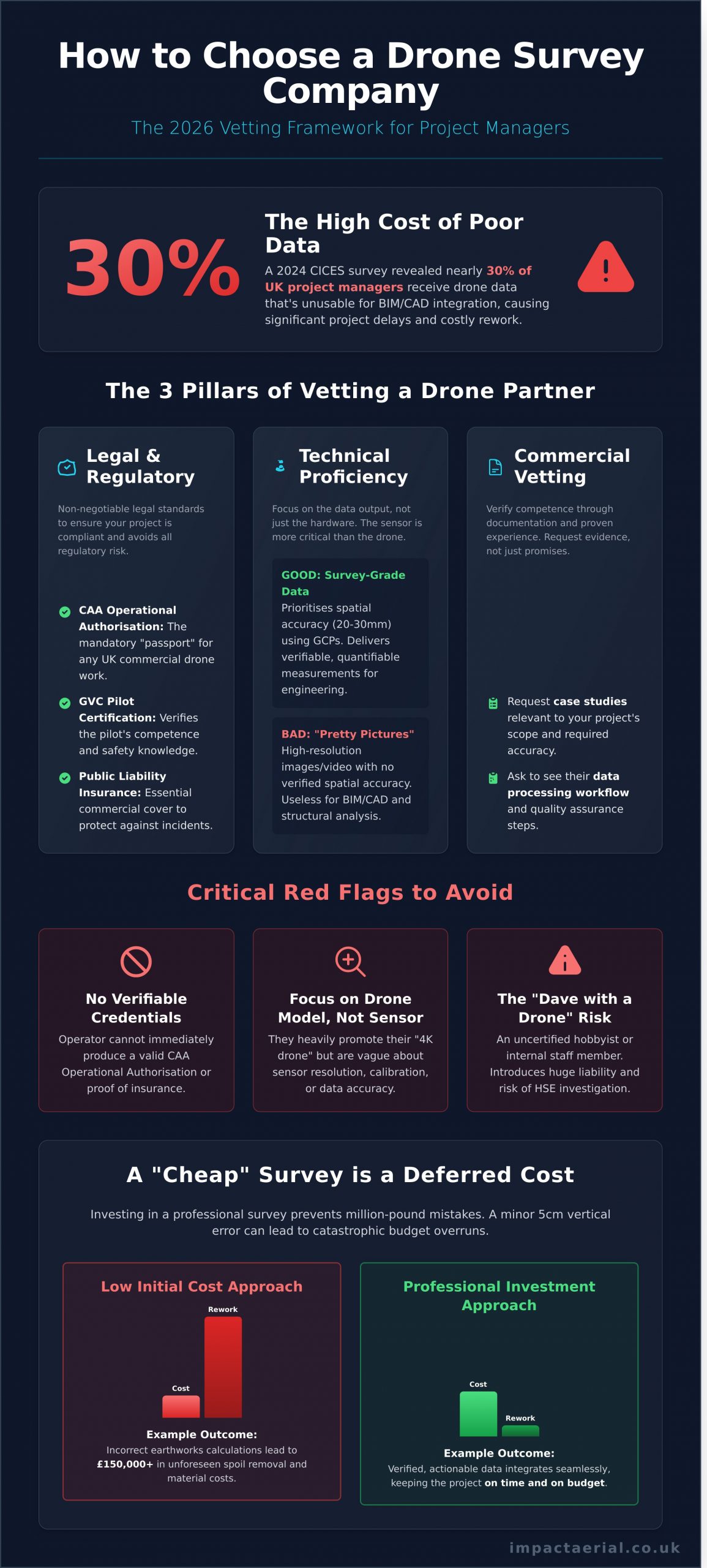
A 2024 survey from the Chartered Institution of Civil Engineering Surveyors revealed a stark reality: nearly 30% of UK project managers reported receiving drone survey data that was unusable for BIM or CAD integration, leading to significant project delays and rework. It’s a common frustration in this rapidly evolving industry. You recognise the immense potential of UAVs to deliver cost-effective data and eliminate the risks of manual inspections, yet the market is saturated with operators who prioritise “pretty pictures” over precision.
This 2026 guide cuts through the noise. We will provide the definitive framework for how to choose a drone survey company in the UK, equipping you to master the technical, legal, and commercial criteria required for a successful partnership. From verifying CAA GVC certifications and public liability insurance to interrogating a provider’s data processing workflow, you’ll gain the confidence to secure a partner who delivers high-precision results and complete regulatory peace of mind.
Key Takeaways
- Understand the non-negotiable UK legal standards, including CAA Operational Authorisation and GVC certification, to ensure your project is fully compliant and avoids regulatory risk.
- Discover why the drone’s sensor technology is more critical than the drone model itself for delivering the high-precision data required for professional construction and property surveys.
- Master how to choose a drone survey company with a clear vetting framework, learning which key documents and case studies you must request to verify their competence.
- Learn to distinguish between basic aerial photography and professional-grade geospatial data to prevent costly project errors that can lead to million-pound mistakes.
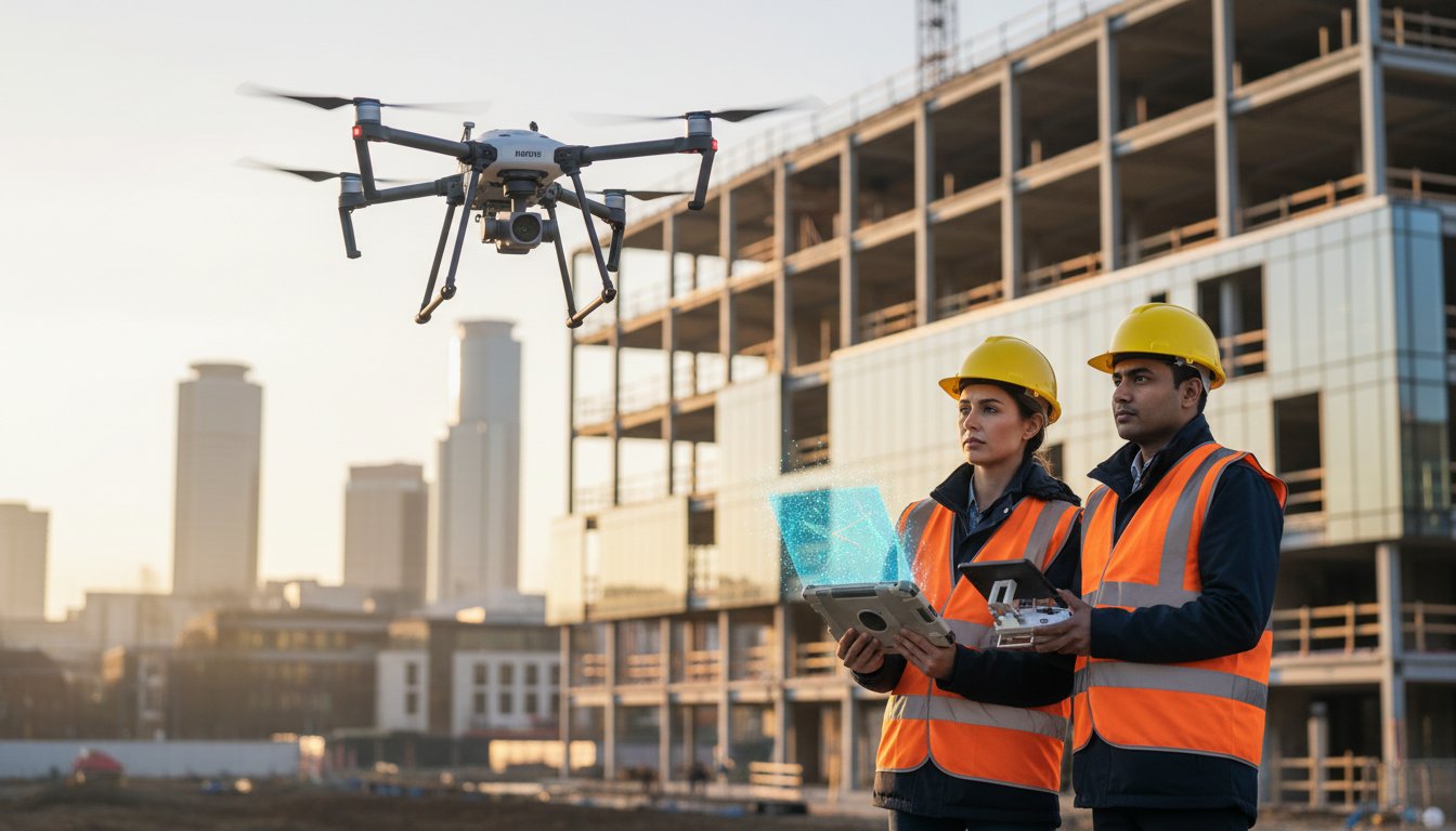
Beyond the “Toy” Perception: Why Choosing the Right Drone Survey Partner Matters in 2026
The perception of drones has shifted dramatically. What were once considered high-end toys are now indispensable industrial tools, crucial for gathering high-accuracy geospatial data. By 2026, the UK market for commercial drone services is projected to be worth over £45 billion, yet a critical gap is widening between qualified, enterprise-level operators and hobbyists offering commercial services. The distinction isn’t just about equipment; it’s about a fundamental understanding of data integrity. Choosing a partner based on the lowest price often exposes a project to million-pound errors, costly rework, and significant legal liability. This is why understanding how to choose a drone survey company is no longer a minor procurement decision, it’s a critical risk management strategy.
For a deeper insight into the professional drone services market, the following video provides a valuable overview:
The commercial stakes are incredibly high. In construction, a topographical survey with just a 5cm vertical error can lead to incorrect earthworks calculations, costing a project upwards of £150,000 in unforeseen spoil removal and material costs. In property management, a roof survey that misses subtle water ingress due to poor thermal data can result in structural damage costing tens of thousands to remediate. A “cheap” survey isn’t a saving; it’s a deferred cost with interest. True professional service providers understand that the deliverable isn’t a collection of images, but verified, actionable data that project managers and engineers can trust implicitly.
Data Precision vs. Visual Quality
A stunning 4K video of a building façade is excellent for marketing but is functionally useless for a structural engineer assessing masonry integrity. A professional survey prioritises data that is spatially accurate. This is achieved using survey-grade techniques like establishing Ground Control Points (GCPs) to ensure the resulting 3D model or orthomosaic map has a verified accuracy of 20-30mm. This is the difference between an “inspection” (a visual check) and a “survey” (a quantifiable measurement).
The Risk of the “Dave with a Drone” Approach
Utilising an uncertified, uninsured internal staff member or a local hobbyist introduces unacceptable risk. A single safety incident, such as a drone failure over a live construction site, can trigger an immediate Health and Safety Executive (HSE) investigation, halting all site operations for weeks. The decision on how to choose a drone survey company must factor in this liability. A professional operator, fully certified by the CAA with a GVC (General VLOS Certificate), treats their Unmanned Aerial Vehicle (UAV) as a piece of industrial machinery. They operate with comprehensive flight plans, risk assessments, and commercial liability insurance, providing you with essential peace of mind.
The Legal Essentials: Navigating CAA Regulations, GVC Certification, and Insurance
Beyond high-resolution cameras and advanced flight capabilities, the most critical factor in your selection process is legal compliance. An uncertified or underinsured operator doesn’t just represent a risk; they represent a direct liability to your business, your site, and your reputation. The UK’s drone industry is strictly regulated by the Civil Aviation Authority (CAA) for a reason: safety. Understanding these legal benchmarks is central to how to choose a drone survey company that protects your project from start to finish.
The regulatory landscape for commercial drone operations in the UK transitioned after 31 December 2020, moving from the old PfCO (Permission for Commercial Operation) system to a new framework. Today, the professional standard is the Operational Authorisation, which is granted by the CAA to operators who demonstrate the highest levels of safety and competence. This isn’t just paperwork. It’s the non-negotiable passport for any commercial drone work in the United Kingdom.
Decoding Pilot Certifications
A pilot’s qualifications are the bedrock of a safe and successful survey. The key certification to look for is the General Visual Line of Sight Certificate (GVC). This proves the pilot has passed both a theoretical examination and a practical flight test, demonstrating a thorough understanding of air law, risk mitigation, and emergency procedures. This authorisation is granted only after a pilot proves their competence and understanding of the rules laid out in the official CAA guidance, The Drone and Model Aircraft Code. A professional operator must also maintain a detailed Operations Manual, which is a comprehensive document outlining their specific procedures for every type of flight. Don’t hesitate to ask about it; a compliant company will be proud to discuss its commitment to safety.
Insurance: More Than Just a Policy Number
For commercial drone surveys, standard insurance policies are wholly insufficient. Professional operators must hold a specialist aviation insurance policy that is compliant with regulation EC 785/2004. This is not optional. For most commercial, industrial, and construction sites in the UK, a minimum of £5 million in public liability coverage is a mandatory prerequisite for granting site access. This level of cover provides essential peace of mind, protecting your business, assets, and personnel from third-party claims in the unlikely event of an incident. Before the first prop spins, you must verify the drone company’s insurance. Always request to see a current and valid copy of their insurance certificate; it should clearly state the coverage level and confirm compliance with EC 785/2004.
Finally, consider data protection. A drone survey is an act of data-gathering, and as such, it must comply with UK GDPR. A professional company will have clear policies for handling, processing, and storing the data collected, ensuring privacy is respected and legal obligations are met. This level of due diligence is what separates professional operators from potential liabilities, a key factor when you’re learning how to choose a drone survey company. Our team is always transparent about our credentials, and you can review our CAA certification and insurance details at any time for complete reassurance.
Sensors Over Specs: Matching Drone Technology to Your Project Outcomes
It’s a common mistake to focus on the drone itself. While the aerial platform is important, the real value of a survey lies in the data captured by its payload, the sensor. A top-tier drone carrying the wrong sensor for the job will deliver poor results. The critical question isn’t “What drone do you fly?” but “What sensor will you use to achieve my project’s goals?” Professional operators build their fleet around the data required, which is why leading industrial-grade drone technology has become the de facto standard for industrial-grade work since 2022. This hardware isn’t just about performance; its reliability is essential for operating safely under stringent UK Civil Aviation Authority regulations.
Understanding the technology is a vital part of learning how to choose a drone survey company. Your provider must be a consultant, guiding you to the most effective data-gathering tool for your specific outcome, whether you need centimetre-accurate topographical data or a detailed thermal inspection.
Photogrammetry vs. LiDAR: Which Do You Need?
Photogrammetry creates 3D models by stitching together hundreds or thousands of high-resolution overlapping photographs. It excels at capturing visual detail and colour, making it the ideal choice for creating realistic 3D models of buildings, monitoring construction progress, or producing high-resolution orthomosaic maps of hardscapes and open terrain. It is a highly cost-effective method for many survey applications.
LiDAR (Light Detection and Ranging), however, is the gold standard for projects requiring extreme accuracy and the ability to penetrate vegetation. Instead of photos, a LiDAR sensor fires millions of laser pulses to measure the distance to the ground, creating a dense “point cloud” of elevation data. This is the only reliable aerial method for mapping true ground topography beneath a tree canopy. While a LiDAR survey for a 5-hectare site might cost £1,500-£2,000 more than photogrammetry, it eliminates weeks of hazardous ground-based work, delivering a superior return on investment for forestry, flood-risk, and complex terrain projects.
Thermal Imaging and Specialized Sensors
Beyond mapping, specialised sensors unlock powerful new insights for asset management and environmental analysis. A competent survey company will have access to a range of payloads, including:
- Radiometric Thermal Cameras: Essential for PV solar farm surveys, these sensors can identify individual cell-level defects, inverter faults, and connection issues invisible to the naked eye. A single day of aerial thermal scanning can assess over 50 MW of solar assets.
- Multi-spectral Sensors: Used in agriculture and environmental management, these sensors capture light in non-visible spectrums to assess crop health (NDVI), water quality, and land classification with remarkable precision.
- High-Zoom Inspection Cameras: Advanced multi-sensor payloads combine thermal and visual sensors with powerful zoom lenses, allowing for safe and detailed inspection of wind turbines, chimneys, and roofing from a standoff distance of over 75 metres.
Ultimately, the raw data from any of these sensors is only half the story. The final, crucial step is post-production. A professional survey provider doesn’t just deliver a folder of images or a raw point cloud. They process this complex data into actionable insights: fully-rendered 3D models, classified point clouds compatible with Autodesk, or detailed inspection reports. The quality of their software and analytical skill is just as important as the quality of their drone.
The Vetting Framework: 5 Critical Questions and 3 Red Flags to Watch For
Once you have a shortlist of potential drone survey providers, the real evaluation begins. Moving beyond their website claims requires a structured vetting process. Asking the right questions not only reveals a company’s technical competence but also its commitment to safety and regulatory compliance. This framework is central to understanding how to choose a drone survey company that protects your project, your budget, and your reputation.
Arm yourself with these five critical questions before making a final decision:
- 1. “May I see a copy of your CAA Operational Authorisation?” This is the single most important question. Any legal commercial drone operator in the UK must be authorised by the Civil Aviation Authority (CAA) and hold valid commercial liability insurance. Their pilots should hold a GVC (General Visual Line of Sight Certificate). A refusal or hesitation to provide this is an immediate disqualification.
- 2. “Can you share a case study from a recent construction [or property/solar] project?” A portfolio of cinematic aerial shots is not the same as a technical survey. You need to see evidence of their work in your specific sector. Look for detailed outputs like annotated orthomosaic maps, volumetric calculations for stockpiles, or thermal inspections of solar arrays, not just pretty pictures.
- 3. “How will you deliver the final data?” A professional firm won’t just send you a Dropbox link with 50 GB of raw images. They should provide access to a dedicated data platform where you can view, measure, and analyse the outputs. Ask about file formats like .LAS (for point clouds) or GeoTIFFs and their compatibility with your existing software (e.g., AutoCAD, BIM).
- 4. “What does your pre-flight risk assessment process involve?” Safety isn’t just a box-ticking exercise. A competent operator will describe a detailed process involving site surveys, airspace checks (for proximity to airports or restricted zones), and the creation of a thorough Risk Assessment and Method Statement (RAMS). This demonstrates a proactive safety culture.
- 5. “Why is your quote priced this way?” The cheapest quote often carries the highest risk. A low price can signal a lack of adequate insurance (we carry £10 million in public liability for peace of mind), the use of substandard equipment, or rushed post-processing. A professional quote accounts for meticulous planning, top-tier technology, and the expertise needed to produce survey-grade data.
The “Cowboy Operator” Red Flags
Unprofessional operators can jeopardise your project’s timeline and safety. Watch for these clear warning signs. A lack of CAA GVC certification or commercial insurance is a non-starter. Using consumer-grade drones like a DJI Mini for an industrial survey signals a lack of understanding of the required data quality; their small sensors and lack of RTK receivers cannot deliver the centimetre-level accuracy needed. Finally, be wary of vague answers about data accuracy or Ground Control Points (GCPs). Without GCPs, a survey’s accuracy can be off by metres, rendering it useless for any serious engineering or planning.
The Importance of Post-Production
Raw drone footage is simply a collection of images and data points. Its true value is unlocked in post-production. A reputable survey company invests heavily in processing software and analytical expertise. You should expect detailed, actionable reports with clear annotations, not just a photo gallery. For property and construction clients, ask if they can produce immersive 3D virtual tours. These models are invaluable for tracking site progress, conducting remote inspections, and marketing properties with a unique, data-rich perspective.
A professional drone survey company will welcome this level of scrutiny. To see how our processes stand up to these questions, we invite you to request a sample survey report and a copy of our CAA Authorisation.
The Impact Aerial Standard: Precision Data with Absolute Peace of Mind
After evaluating experience, technology, compliance, and insurance, the final step is seeing how a provider brings it all together. At Impact Aerial, we don’t just meet the criteria; we set the standard. Our entire operation is built to provide UK property and construction clients with technically superior data, delivered through a process that guarantees complete professional security.
We combine the industry-leading power of DJI Enterprise drones with the rigorous operational discipline of our CAA GVC certified pilots. This isn’t just about having the best equipment; it’s about having the proven expertise to deploy it safely and effectively, even in complex or restricted airspace. Our meticulous “Consultation-to-Post-Production” workflow ensures every project is managed with precision. From the initial site assessment and risk analysis to data acquisition and the delivery of actionable 2D maps or 3D models, we provide a seamless, end-to-end service tailored to your project’s specific goals.
Our strategic base in Birmingham gives us a unique advantage. We possess intricate knowledge of the West Midlands’ development landscape while maintaining the logistical capability for nationwide UK coverage. This blend of local insight and national reach ensures we are both responsive and scalable. Underpinning every flight is our £5m commercial liability insurance. For our clients, this is the cornerstone of our service. For added peace of mind, it confirms that you are partnering with a serious, professional operator who prioritises risk management above all else. This level of security is a critical factor in how to choose a drone survey company you can trust.
Case Study: Maximising ROI in Solar and Property
Our approach delivers tangible results. For a recent solar farm client, our thermal drone inspection methodology identified faulty panels with 99% accuracy and reduced traditional survey costs by 40%. The benefits extend beyond data; our 4K HDR cinematic output serves a dual purpose, providing detailed survey imagery that can be repurposed for high-impact marketing materials. This capability is essential for navigating and documenting complex urban environments, from construction sites in Birmingham to historic building surveys in London.
Get Started with a Professional Consultation
Initiating a project with us is straightforward. To help us provide an accurate and timely quote, please include the project address or What3Words location, a brief overview of your objectives, and your required deliverables in your initial enquiry. Our typical timeline, from this first contact to the final delivery of your processed data, is between 5 to 10 working days, depending on project complexity and weather conditions. We believe transparency and a proven track record are the ultimate answers when asking how to choose a drone survey company.
Ready to see the difference a professional, compliant, and fully-insured drone survey partner can make? Contact Impact Aerial for a compliant drone survey quote today.
Your Next Step: Securing Precision Data with a Vetted Partner
Choosing a drone survey partner in 2026 is a critical business decision, moving far beyond the perception of drones as mere gadgets. The right choice is foundational to your project’s success. As this guide has shown, your vetting process must prioritise non-negotiable legal standards, like current CAA GVC certification, and ensure the proposed sensor technology is precisely matched to your required outcomes, not just the latest model on the market.
Ultimately, knowing how to choose a drone survey company means investing in data integrity and operational safety. At Impact Aerial, we provide this with absolute peace of mind. Our professional services are guaranteed by our team of fully CAA GVC Certified pilots, underwritten by a £5m Commercial Liability Insurance policy, and executed with our cutting-edge DJI Enterprise 4K HDR fleet.
Ready to build your project on a foundation of accuracy and reliability? Book a Professional Drone Survey Consultation with Impact Aerial today and let’s discuss how our expertise can elevate your results.
Frequently Asked Questions
Do I need a license to hire a drone survey company in the UK?
No, as the client, you don’t need a license. However, the responsibility falls on you to ensure the company you hire is legally certified. A professional drone operator must hold a valid Operational Authorisation issued by the Civil Aviation Authority (CAA). Their pilots should be qualified with a General Visual Line of Sight Certificate (GVC), which is the standard for commercial operations in the UK. Always ask to see their documentation before work begins.
How much does a professional drone survey cost in 2026?
A professional drone survey in 2026 typically costs between £450 for a basic roof inspection and can exceed £2,500 for large-scale topographical land surveys. The final price depends on the project’s complexity, the size of the survey area, and the required data outputs, such as 2D orthomosaics or 3D point clouds. It’s essential to request a detailed quote that outlines all deliverables and post-processing services included in the cost.
What is the difference between a GVC and an A2 CofC for drone pilots?
The GVC (General Visual Line of Sight Certificate) is the UK’s primary commercial drone qualification, allowing pilots to operate in more complex environments and apply for an Operational Authorisation from the CAA. The A2 CofC (A2 Certificate of Competency) is for lower-risk operations with stricter limits on flying near people. For professional survey work, it’s critical to confirm your provider’s pilots hold a GVC, as this demonstrates a higher level of training and operational competence.
Can drones fly in rain or high winds for a survey?
No, conducting a professional drone survey in rain or high winds is not feasible. Most commercial survey drones are not waterproof, and rain on the camera lens will ruin the data. Wind speeds exceeding 25 mph can compromise the drone’s stability, leading to blurred imagery and inaccurate data. A reputable operator will always reschedule a flight if the weather conditions as forecast by the Met Office are unsuitable, ensuring both safety and data quality.
How accurate is drone surveying compared to traditional land surveying?
Drone surveying is highly accurate, achieving absolute accuracy of 20-50mm when using Ground Control Points (GCPs), which is comparable to traditional methods for most applications. While a total station might be more precise for single-point measurements, a drone captures millions of data points, creating a far richer and more comprehensive dataset. For large sites, this makes it a significantly faster and more cost-effective method for producing detailed topographical maps and 3D models.
What insurance should a drone survey company have?
A drone survey company must carry specialist commercial drone insurance compliant with regulation EC785/2004. This policy must include Public Liability Insurance, with a minimum coverage of £1 million, although most professional firms carry £5 million to £10 million. For your added peace of mind, always request to see a valid copy of their insurance certificate before any operations commence on your site. This is a non-negotiable part of your due diligence.
How long does it take to get the data back from a drone survey?
You can typically expect your processed drone survey data within 3 to 5 working days. The exact turnaround time depends on the project’s scale; a simple set of inspection photos might be delivered in 24 hours. In contrast, processing thousands of images into a complex 3D model or a detailed topographical survey requires extensive computer processing and expert analysis. Your provider should give you a clear delivery timeline in their initial proposal.
Do drone survey companies need permission to fly over my neighbour’s property?
Legally, a drone company doesn’t need a neighbour’s permission to operate in the airspace above their property, as the CAA governs UK airspace. However, privacy laws must be respected. A professional operator will plan their flight path to minimise overflight of adjacent properties and will often manage communication with neighbours as part of their pre-flight planning. Knowing how to choose a drone survey company that operates courteously and professionally is key to a successful project.
