
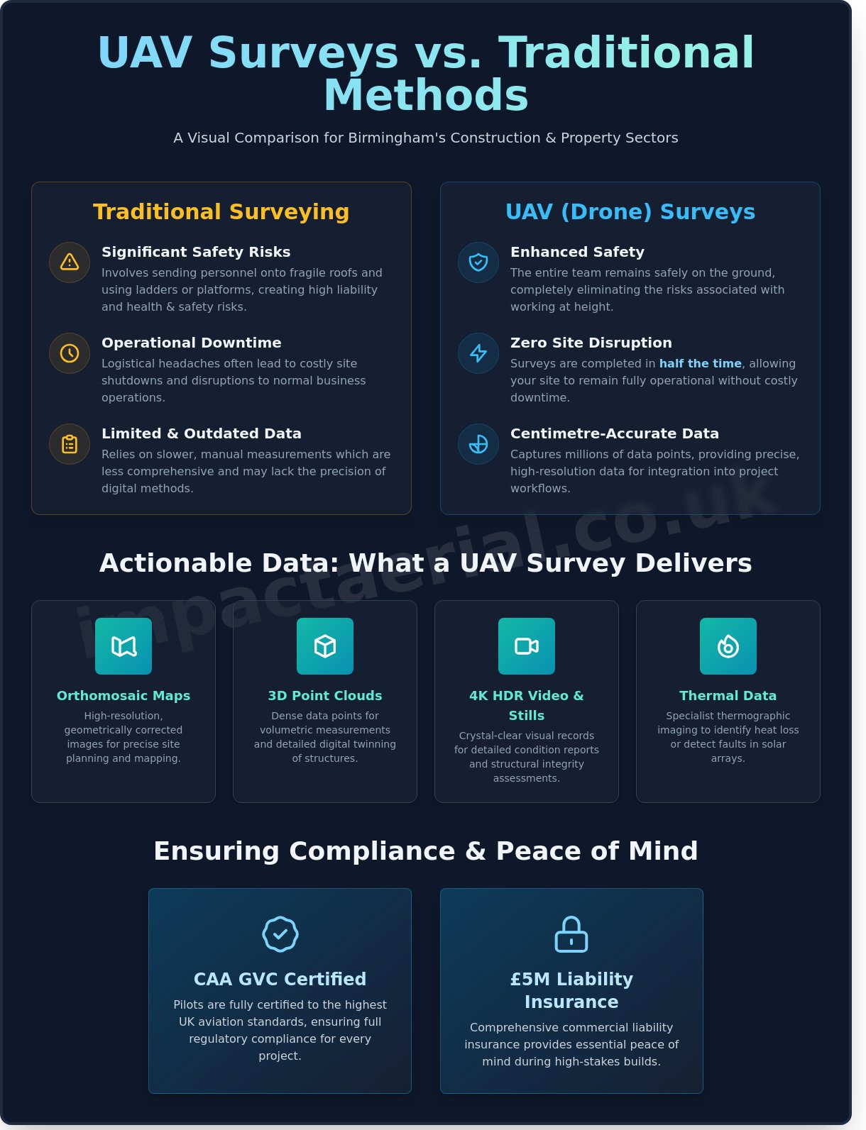
Is it really worth the liability risk of sending a surveyor onto a fragile roof when a drone can capture more accurate data in half the time? Most site managers and developers in the West Midlands know that traditional height inspections are a logistical headache; they often involve significant health and safety risks and costly operational downtime. A professional uav survey birmingham offers a sophisticated, technical alternative to these outdated methods. By utilising advanced aerial technology, we eliminate the need for ladders or platforms. This keeps your site running smoothly and your team safely on the floor.
We understand that your primary concerns are accuracy, safety, and full regulatory compliance. This guide demonstrates how professional UAV surveys provide high-resolution 4K imagery and precise photogrammetry for construction, property, and solar assets with minimal site disruption. You’ll discover how our CAA GVC Certified pilots and DJI Enterprise fleet deliver the technical data you need for added peace of mind. We’ll walk you through the essential steps to secure high-quality aerial data that meets the strictest UK aviation standards while avoiding the high costs and risks of traditional surveying.
Key Takeaways
- Learn how high-resolution data collection provides a safer, faster alternative for surveying Birmingham’s unique mix of historic and modern architecture.
- Understand the technical precision of DJI Enterprise drones and photogrammetry in creating accurate 3D models for complex construction and property projects.
- Discover how a professional uav survey birmingham ensures “Zero Disruption,” allowing your business to remain fully operational during site inspections.
- Explore specialised applications for the property and energy sectors, from comprehensive roof condition reports to thermal surveys for PV solar farms.
- Ensure project compliance by identifying the critical standards required for aerial work, including CAA GVC certification and £5m commercial liability insurance.
What is a UAV Survey and How Does it Serve Birmingham Businesses?
A Unmanned Aerial Vehicle (UAV) survey is a sophisticated method of data collection that uses advanced flight technology to capture high-resolution spatial information. Unlike traditional ground-based methods, a uav survey birmingham project allows for the rapid acquisition of millions of data points across complex environments. This digital-first approach marks a significant shift from manual measurements to automated, centimetre-accurate datasets. For local businesses, this means moving beyond simple aerial photography to “actionable data” that can be directly integrated into architectural software and project management workflows.
To better understand the technical precision and accuracy required for these professional operations, watch this helpful video from ARPAS-UK:
The Role of Drones in the West Midlands Economy
Birmingham is currently witnessing a massive transformation, driven by the Big City Plan, a 20-year strategy aimed at creating 50,000 new jobs and contributing £2.1 billion to the economy annually. This scale of regeneration requires constant, high-speed site monitoring that traditional surveying cannot match. Drones are now essential for commercial property developers in the city centre and industrial warehousing firms across the Black Country.
The city’s unique mix of Victorian heritage assets, such as those in the Jewellery Quarter, and modern structures like the Curzon Street HS2 site, presents a complex aerial environment. Our local expertise is vital for navigating these challenges. Operating a uav survey birmingham requires meticulous planning and strict adherence to CAA GVC certifications. This ensures that data collection is not only high-quality but also fully compliant with UK aviation safety regulations, providing clients with essential peace of mind during high-stakes builds.
Key Deliverables: What You Get from a Professional Survey
A professional aerial survey produces a suite of technical assets designed for precision and analysis. These deliverables provide a comprehensive view of any site, whether it’s a sprawling industrial estate or a single historic rooftop. Key outputs include:
- Orthomosaic Maps: High-resolution, geometric images corrected for topographic relief, used for precise site planning and mapping.
- 3D Point Clouds: Dense sets of data points that allow for volumetric measurements and detailed digital twinning of structures.
- 4K HDR Video and Stills: Crystal-clear visual records used for detailed condition reports and structural integrity assessments.
- Thermal Data: Specialist thermographic imaging to identify heat loss in commercial buildings or detect electrical faults in solar arrays.
By utilising our fleet of DJI Enterprise drones, we provide data that is structured, methodical, and ready for immediate professional use. This level of detail allows project managers to identify potential issues long before they become costly delays.
Technical Capabilities: The Science Behind Accurate Drone Data
Achieving high-fidelity results during a uav survey birmingham relies on more than just flight skills; it requires a sophisticated integration of aerospace engineering and advanced geomatics. Our fleet consists of DJI Enterprise drones, which provide the flight stability needed to capture clear data in the complex wind currents often found around Birmingham’s high-rise developments. These aircraft are designed for precision, allowing us to maintain a steady hover and consistent flight path even in challenging urban environments.
Enterprise-Grade Hardware vs. Consumer Drones
Professional work demands a survey drone with built-in system redundancies. While consumer models lack the necessary fail-safes for dense city centres, DJI Enterprise models feature dual IMUs and compasses to ensure flight reliability. Sensor quality is the critical differentiator here. We utilise 1-inch 20MP CMOS sensors that capture significantly more light and detail than standard hobbyist cameras. This hardware allows for 4K HDR imaging that reveals minute cracks, thermal leaks, or structural defects that are often invisible to the naked eye. Adhering to RICS drone surveying guidance ensures these technical outputs meet the rigorous standards expected by chartered surveyors and asset managers across the West Midlands.
Photogrammetry and 3D Modelling
Photogrammetry is the engine behind our centimetre-accurate digital twins. By capturing hundreds of overlapping images from multiple angles, we use specialised software to triangulate points in 3D space. “Photogrammetry transforms thousands of 2D images into a single, centimetre-accurate 3D representation of a physical asset.” This data is vital for Birmingham architects and urban planners who need to visualise how new structures interact with existing city infrastructure. It provides a level of spatial context that traditional photography simply cannot offer.
The journey from raw flight data to a final report involves intensive processing. After the flight, we convert gigabytes of 4K visual data into orthomosaic maps and dense point clouds. This workflow provides a level of detail that traditional ground-based methods can’t match within the same timeframe. Whether it’s a heritage building near New Street or a new build in Digbeth, conducting a uav survey birmingham provides stakeholders with a comprehensive digital record. If you’re looking to upgrade your site documentation, Impact Aerial provides the technical expertise to turn aerial footage into actionable insights for your next project.
The Business Case: UAV Surveys vs. Traditional Methods
Traditional access methods like scaffolding, cherry pickers (MEWPs), and steeplejacks have long been the industry standard for high-level inspections. However, these methods carry significant logistical burdens. A uav survey birmingham offers a streamlined alternative that prioritises operational continuity. While scaffolding can take several days to erect and requires local council pavement licences that often cost upwards of £100 per week, a drone can be deployed and recording data within 30 minutes of arriving on site.
The “Zero Disruption” advantage is vital for Birmingham’s busy commercial districts like Colmore Row or the Jewellery Quarter. Businesses can remain fully operational while we collect high-resolution data; there’s no need to close car parks or restrict pedestrian access. This efficiency translates to direct savings. By keeping personnel safely on the ground, we eliminate the primary risks associated with working at height. It’s a method that replaces weeks of planning with a few hours of precision flight.
Cost-Efficiency and ROI
The financial argument for aerial data goes beyond the initial quote. Traditional methods involve hidden costs such as specialised labour for assembly, security for on-site equipment, and extended project timelines. Rapid data collection allows property owners to identify defects and commission repairs 80% faster than manual methods. For developers, the value lies in repeatable data for long-term construction site monitoring. Having a consistent, digital record of progress ensures that projects stay on schedule and within budget, providing a clear return on investment through improved oversight.
Safety and Risk Mitigation
Safety is the cornerstone of our professional services. By utilising aerial remote sensing, we significantly reduce “Work at Height” incidents. Drones can easily access structurally unsound roofs or hazardous industrial chimneys where sending a human would be too dangerous. Every flight we conduct adheres strictly to The Drone and Model Aircraft Code, ensuring full legal compliance. We produce comprehensive Risk Assessment and Method Statements (RAMS) for every project. This gives our clients peace of mind that all operations are managed by CAA GVC Certified experts who prioritise the safety of the public and the property.
Specialised Applications for Birmingham Industries
Birmingham’s industrial landscape requires data precision that traditional ground-based methods can’t provide. A professional uav survey birmingham delivers a technical advantage across sectors ranging from logistics to heritage conservation. By deploying CAA GVC Certified pilots, businesses ensure compliance while gathering high-resolution intelligence that informs critical decision-making.
Commercial Property and Roof Inspections
For commercial real estate assets, aerial inspections have become the standard for proactive maintenance and insurance compliance. Our enterprise-grade drones identify Reinforced Autoclaved Aerated Concrete (RAAC) issues, water ingress points, and hairline structural cracks that are often invisible from the ground. On new-build projects, we use drones for “snagging” to verify that contractors have met exact specifications before final handover. High-angle perspectives are particularly beneficial for large industrial units in areas like Erdington or Solihull, where traditional scaffolding costs for a basic roof check can often exceed £2,000. Drones eliminate this overhead while providing a digital audit trail of the building’s condition.
Thermal Surveys for Solar and Energy
As energy providers expand their footprint across the West Midlands, maintaining efficiency is critical for ROI. Our PV Solar Farm Thermal Surveys use radiometric sensors to detect “hot spots” within individual cells. These anomalies indicate faulty bypass diodes or internal short circuits that significantly reduce energy output. Beyond solar, we provide heat loss surveys for Birmingham’s older building stock to assist with modern decarbonisation targets. Thermal drones can identify faults invisible to the naked eye, allowing for targeted repairs rather than costly, full-scale renovations.
Construction and Heritage Documentation
In the construction sector, we facilitate progress monitoring through precise volumetric analysis for earthworks. Instead of manual surveying, which can take days, a drone captures data for stockpile volumes in minutes with high accuracy. This data allows site managers to track material movement against project timelines. For the city’s historical landmarks, such as those in the Jewellery Quarter, drones provide non-invasive archaeology and heritage site documentation. We create detailed 3D models using photogrammetry to preserve the structural integrity of Grade II listed buildings without disturbing the site or requiring heavy machinery access.
For added peace of mind, all our specialised data-gathering operations are backed by comprehensive commercial liability insurance and strict adherence to CAA regulations.
Ensuring Compliance: Choosing a UAV Partner in Birmingham
Selecting a provider for a uav survey birmingham requires more than just looking at a portfolio of aerial photographs. It’s about risk management and legal certainty. Professional operators must hold a valid General Visual Line of Sight Certificate (GVC) issued by the Civil Aviation Authority (CAA). This isn’t just a badge; it’s a legal requirement for complex commercial operations in urban environments. For added peace of mind, we maintain £5m commercial liability insurance. This figure is the industry gold standard, ensuring that clients are fully protected against unforeseen incidents during data collection in busy metropolitan areas.
The Legal Framework: CAA Regulations in 2026
The distinction between hobbyist flight and professional drone services has never been clearer. Under 2026 CAA rules, the GVC allows pilots to operate in the “Specific Category.” This is vital for flying in congested areas like Birmingham city centre where separation distances are strictly monitored. Every flight we conduct follows a comprehensive Flight Operation Manual. This document acts as our internal law, detailing safety protocols, emergency procedures, and equipment maintenance schedules. It ensures that every project meets the same high standard of safety and technical excellence.
Why Local Expertise Matters
Birmingham’s airspace is notably complex. Much of the city falls within Flight Restricted Zones (FRZs) due to the proximity of Birmingham International Airport (BHX). Navigating these restrictions requires precise coordination with Air Traffic Control and the timely filing of NOTAMs (Notice to Airmen) to inform other airspace users of our presence. As a local specialist for drone services in the West Midlands, Impact Aerial manages this entire administrative process. We handle the logistical heavy lifting so you don’t have to.
Our pre-flight planning process is meticulous and includes:
- Detailed site risk assessments (RAMS) tailored to the specific Birmingham location.
- Securing formal landowner permissions and informing local authorities where necessary.
- Analysing hyper-local weather patterns that can affect flight stability between tall buildings.
- Real-time airspace monitoring using advanced digital tools to ensure zero interference.
Our approach ensures your uav survey birmingham is completed efficiently, legally, and to the highest technical specification. We manage the end-to-end process from the initial consultation through to the final data delivery. By choosing a partner that understands the local geography and the 2026 regulatory environment, you’re investing in data that is both high-quality and fully compliant.
Secure High-Precision Data for Your Next Birmingham Project
Transitioning from traditional manual inspections to a professional uav survey birmingham provides immediate efficiency gains and significantly reduces onsite health and safety risks. By deploying the latest DJI Enterprise 4K HDR fleet, businesses across the West Midlands can access centimetre-accurate photogrammetry and high-resolution thermal data that traditional methods simply can’t match. This technical precision allows for faster decision-making in sectors ranging from commercial property development to infrastructure maintenance.
Impact Aerial prioritises safety and compliance above all else. For added peace of mind, every operation is conducted by CAA GVC Certified pilots and backed by £5m commercial liability insurance. This meticulous approach ensures that your data-gathering is both legally compliant and of the highest professional standard. Whether you’re managing a complex construction site or a sensitive heritage building, our team delivers the expert technical consultancy required to showcase your project from every perspective.
Contact Impact Aerial for a Professional UAV Survey Quote to start capturing the high-quality aerial insights your business deserves today.
Frequently Asked Questions
Is it legal to conduct a UAV survey in Birmingham city centre?
It’s legal to conduct a uav survey birmingham city centre as long as the operator holds the correct Civil Aviation Authority (CAA) GVC or PfCO certification. Operations in built-up areas like the Jewellery Quarter or Colmore Row must adhere to specific category regulations. Our pilots perform detailed risk assessments and secure necessary flight permissions to ensure every operation remains fully compliant with UK aviation law.
How much does a drone survey cost compared to traditional scaffolding?
Drone surveys typically offer a 60% to 70% cost reduction compared to traditional scaffolding or cherry pickers. Scaffolding for a commercial building often requires significant investment in hire fees and labour hours for installation. A UAV inspection eliminates these overheads, allowing for a rapid deployment that captures comprehensive data in a fraction of the time required for manual access methods.
What weather conditions can a survey drone operate in?
Our DJI Enterprise commercial drones can operate in wind speeds up to 22mph and light precipitation. We monitor Met Office forecasts 24 hours in advance to ensure safe flying conditions. If visibility drops below 5km or wind gusts exceed manufacturer limits, we reschedule the flight to maintain our strict safety standards and ensure the highest possible data quality.
How long does it take to receive the data after a UAV survey?
You’ll typically receive the processed data within 24 to 48 hours of the flight completion. For a uav survey birmingham project involving complex photogrammetry or 3D modelling, processing may take up to 72 hours. We deliver high-resolution 4K imagery and technical reports via secure cloud-based links, allowing your team to access critical building data almost immediately for project planning.
Do I need to be present on-site during the drone flight?
You don’t need to be present on-site while our pilots conduct the flight. We handle all aspects of the operation, from the initial pre-flight survey to the final landing. If you prefer to watch the live feed, we can provide a ground station monitor. This allows you to view the high-quality 4K footage in real-time as the drone inspects specific assets or structural points.
Can drones perform indoor surveys for large Birmingham warehouses?
Drones are highly effective for indoor surveys in large Birmingham warehouses or industrial units. We use specialised aircraft equipped with 360-degree obstacle avoidance and protective cages to navigate tight internal spaces safely. This method allows us to inspect high-level racking, roof trusses, and HVAC systems without the need for ladders or mobile elevating work platforms, significantly reducing health and safety risks.
What insurance cover should a professional drone operator have?
A professional operator must hold commercial liability insurance that complies with EC 785/2004 regulations. We carry £5 million in public liability insurance as standard for every project. This provides added peace of mind for our clients, ensuring that all third-party risks are fully covered during aerial data gathering or structural inspections in busy urban environments or construction sites.
How accurate is the data gathered during a UAV land survey?
UAV land surveys achieve high levels of precision, often delivering Ground Sample Distance accuracy within 1cm to 3cm. By using RTK enabled drones and established ground control points, we produce survey-grade maps and 3D models. This level of detail is sufficient for topographical mapping, volumetric measurements, and detailed construction site monitoring across the West Midlands, providing a reliable alternative to traditional ground-based methods.