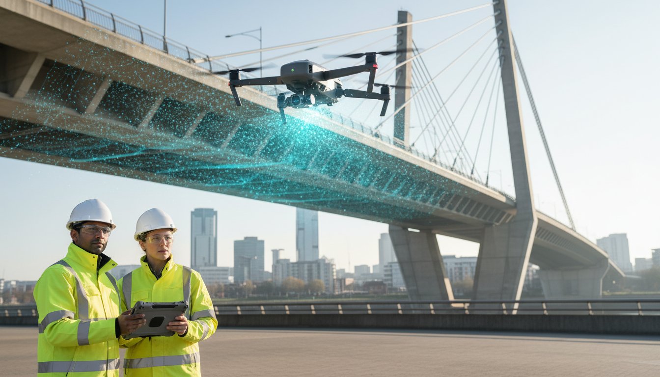
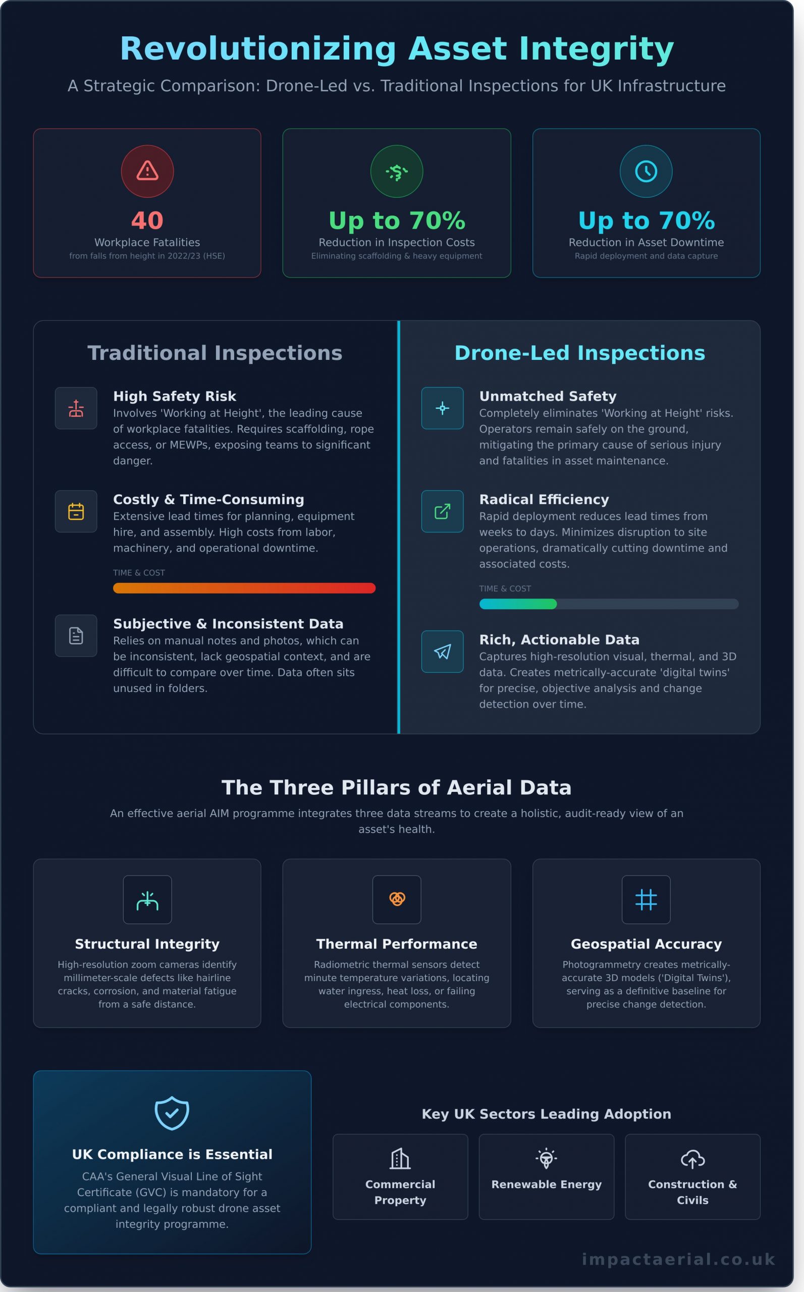
According to the UK’s Health and Safety Executive (HSE), falls from height were responsible for 40 workplace fatalities in 2022/23, making it one of the leading causes of death on the job. What if your team never had to leave the ground to conduct a comprehensive structural assessment again? It’s a challenge every infrastructure manager faces: balancing asset integrity with team safety, all while trying to control the spiralling costs of scaffolding and manual inspections.
You know that traditional methods aren’t just high-risk; they often produce photos and notes that sit in a folder, disconnected from actual maintenance planning. This guide provides a clear, professional framework for implementing drone asset integrity management. We promise to show you precisely how this CAA-regulated approach delivers audit-ready reports, transitions your strategy from reactive to proactive, and can reduce inspection costs by up to 70%. We’ll explore the essential technology, the UK regulatory landscape for 2026, and a step-by-step process for integrating high-quality aerial data into your workflows for tangible, long-term returns.
Key Takeaways
- Discover how to enhance site safety by eliminating ‘Working at Height’ risks while reducing asset inspection downtime by up to 70%.
- Uncover the true cost of traditional access methods by comparing the extensive lead times and hidden expenses of scaffolding against rapid drone deployment.
- Navigate complex UK regulations by understanding why the CAA’s GVC certification is essential for a compliant and legally robust drone asset integrity management programme.
- Learn a step-by-step framework for implementing your drone inspection strategy, including how to identify critical assets and select the optimal sensor payload.
What is Drone Asset Integrity Management?
Asset Integrity Management (AIM) is the systematic process of ensuring an asset performs its required function effectively, safely, and sustainably throughout its lifecycle. While you can find a foundational overview by asking What is Asset Integrity Management?, by 2026, this discipline is being fundamentally redefined by aerial data. The era of relying solely on costly scaffolding, rope access teams, and subjective manual visual inspections is giving way to a digital-first, data-driven methodology. This shift is central to modern drone asset integrity management.
This transformation is particularly critical for the UK’s extensive portfolio of aging infrastructure. For asset managers responsible for everything from Victorian-era railway bridges to 1980s commercial office blocks, “Life Extension” is no longer a theoretical goal; it’s an economic necessity. Drones provide the high-fidelity data needed to make precise, predictive maintenance decisions, deferring multi-million-pound replacement costs and maximising operational lifespan. It’s about capturing objective truth from a safe distance.
This capability is powered by professional-grade equipment. At Impact Aerial, our CAA GVC Certified operations utilise the latest advanced commercial drones, which are sophisticated data-gathering platforms. Capturing detail with 4K High Dynamic Range (HDR) visual sensors and identifying anomalies with radiometric thermal cameras, these systems provide a level of insight that is physically impossible to achieve from the ground, ensuring nothing is missed.
The Core Components of an Aerial AIM Strategy
An effective aerial AIM programme integrates three distinct data streams to create a holistic view of an asset’s health. Each component provides a critical piece of the puzzle for a comprehensive condition assessment.
- Structural Integrity: Using high-resolution zoom cameras, our drones can identify millimeter-scale defects like hairline cracks in concrete, corrosion on steelwork, and signs of material fatigue from a safe standoff distance. This proactive defect identification is the first line of defence against structural failure.
- Thermal Performance: Radiometric thermal sensors detect minute temperature variations invisible to the naked eye. This is crucial for locating water ingress behind a building’s facade, identifying inefficient heat loss from insulation, or pinpointing electrical connections overheating in a substation, often a precursor to critical failure.
- Geospatial Accuracy: Through a process known as photogrammetry, thousands of overlapping images are processed to create a metrically-accurate 3D model, or “digital twin,” of the asset. This model serves as a definitive baseline, allowing for precise change detection and monitoring over time.
Industries Leading the Drone Adoption in the UK
While the applications for drone asset integrity management are diverse, several key sectors in the United Kingdom have become early adopters, driven by clear safety and efficiency benefits.
- Commercial Property and High-Rise Building Management: In the wake of updated building safety regulations post-Grenfell, drones have become the standard for conducting efficient and thorough facade, cladding, and rooftop inspections on tall buildings across London, Birmingham, and Manchester.
- Renewable Energy Infrastructure: With the UK aiming for 70GW of solar capacity by 2035, drones are the only scalable method for inspecting the health of millions of PV panels on solar farms, quickly identifying defective cells and maximising energy output.
- Construction and Heavy Civil Engineering: For large-scale projects like those managed by National Highways, drones provide essential project oversight, from initial topographical surveys and earthworks calculations to ongoing progress monitoring against design plans.
The 4 Pillars of Drone-Led Integrity Inspections
Traditional asset inspections are built on a foundation of compromise, balancing safety risks, operational downtime, and data quality. Modern drone asset integrity management flips this model on its head. Instead of compromise, it delivers enhancement across four critical pillars, creating a safer, faster, and more intelligent approach to maintaining high-value infrastructure.
The operational advantages are built on these core principles:
- Unmatched Safety: Drones completely remove the primary hazard associated with asset inspection: working at height. By eliminating the need for personnel to climb structures or operate from Mobile Elevating Work Platforms (MEWPs), you directly mitigate the leading cause of workplace fatalities in the UK construction and maintenance sectors.
- Radical Efficiency: An entire factory roof, cooling tower, or bridge that once took a week to inspect can now be captured in a single day. Our data shows that drone inspections can reduce on-site time and asset downtime by up to 70% compared to traditional methods, accelerating maintenance cycles and returning assets to service faster.
- Superior Data Depth: We move beyond simple photography. Using advanced photogrammetry techniques, we capture thousands of high-resolution images to create centimetre-accurate, measurable 3D models and point clouds. This “digital twin” provides an objective, data-rich record of an asset’s condition that can be analysed and compared over time.
- Proven Cost-Effectiveness: The direct costs of inspection are slashed. Consider the expense of hiring scaffolding, which can easily exceed £1,200 per week for a commercial structure, or a cherry picker at over £300 per day. A drone operation circumvents these costs entirely, requiring only a certified pilot and a clear flight path.
Transforming Safety Protocols on UK Sites
In the UK, safety isn’t just a priority; it’s a legal requirement governed by stringent HSE regulations. Our CAA GVC Certified pilots are not just expert operators; they are trained risk-management professionals. They conduct detailed pre-flight surveys and create robust operational plans that comply with complex urban and industrial airspace rules. Navigating UK Compliance and CAA Regulations is central to our process, ensuring every operation is meticulously planned for maximum safety. This approach drastically reduces the number of personnel required on-site during an inspection and simplifies the entire Risk Assessment (RA) process, giving you complete peace of mind.
From Visual Data to Actionable Intelligence
The real value of drone asset integrity management is realised when raw data is converted into actionable intelligence. Our process includes meticulous post-production editing to enhance technical clarity, ensuring that engineers and surveyors can easily identify faults. The 4K HDR imagery captured by our DJI Enterprise drones reveals subtle defects like hairline fractures, spalling concrete, or early-stage corrosion that are often invisible to the naked eye from the ground. This high-fidelity data is then formatted to integrate seamlessly into your existing Asset Management Software, BIM models, or GIS platforms. Discover how our data packages are tailored for your platform, turning visual information into predictive maintenance triggers.
Traditional vs. Drone Inspections: A Strategic Comparison
Adopting new technology requires a clear-eyed assessment of its advantages over established methods. When comparing traditional access techniques like scaffolding or rope access with aerial inspections, the strategic benefits of drone asset integrity management become immediately apparent. It’s not simply a like-for-like replacement; it’s a fundamental upgrade in efficiency, safety, and data quality.
The operational differences in speed and cost are stark. Consider the inspection of a 30-metre industrial storage tank:
- Traditional Scaffolding: Involves a multi-stage process of design, permitting, erection, and eventual dismantling. This can introduce a lead time of 2-4 weeks and incur costs often exceeding £20,000, factoring in labour, equipment hire, and operational downtime.
- Drone Inspection: A qualified team can complete planning, risk assessments, and on-site data capture within 2-3 days. The cost is typically between £2,000 and £5,000, representing a saving of over 75% while completely eliminating the need for personnel to work at height.
Beyond the immediate financial savings, drones provide superior data for long-term analysis. An inspector on a scaffold or rope will capture images from slightly different positions on every visit. In contrast, a drone can execute a pre-programmed, automated flight path. This means we can capture high-resolution imagery and sensor data from the exact same GPS coordinates, angles, and distances, year after year. This level of data repeatability is the cornerstone of effective trend analysis, allowing engineers to accurately track the propagation of a crack or the spread of corrosion over time.
A common objection centres on the loss of the “human touch”. This perspective misunderstands the role of the drone. The drone is a data-gathering tool, not the analyst. It empowers a chartered engineer by providing them with comprehensive, high-definition visual and thermal data from inaccessible or hazardous locations. Instead of making subjective assessments in a high-risk environment, the expert can conduct a far more detailed analysis from the safety of an office, reviewing terabytes of objective data to make informed decisions. The drone enhances expert oversight; it doesn’t replace it.
The ROI of Proactive Aerial Monitoring
Calculating the return on investment for regular drone surveys is straightforward. Unplanned downtime for a UK production facility can cost over £200,000 per day in lost output. A proactive drone survey costing less than 2% of that figure can identify potential failures before they become critical. Detecting corrosion at an early stage might result in a £10,000 remediation project, whereas waiting until it compromises structural integrity could lead to a six-figure repair bill. For added peace of mind, our professional services are backed by £5m in commercial liability insurance, safeguarding your assets throughout our operations.
Overcoming Technical Limitations
A professional drone inspection service is equipped to handle the technical complexities of data acquisition. We deploy the right sensor for the job, using high-resolution 48MP cameras for identifying fine structural defects and thermal sensors for detecting moisture ingress or insulation failures. Our GVC certified pilots are not just operators; they are data acquisition specialists, fully versed in the evolving UK Civil Aviation Authority drone regulations that govern complex industrial inspections. We manage the entire data workflow, from capturing terabytes of footage on-site to processing it into actionable 3D models and inspection reports on secure cloud platforms.
Navigating UK Compliance and CAA Regulations in 2026
Deploying drones for drone asset integrity management offers unparalleled efficiency, but it operates within a stringent regulatory framework governed by the UK’s Civil Aviation Authority (CAA). Understanding these regulations isn’t just the pilot’s responsibility; it’s crucial for any organisation commissioning drone services to ensure legal compliance and mitigate risk. As we look towards 2026, the operational standards for commercial drone use are more rigorous than ever, demanding a professional, documented approach to every flight.
The cornerstone of modern UK commercial drone operation is the General Visual Line of Sight Certificate (GVC). This qualification, which officially replaced the legacy Permission for Commercial Operation (PfCO) on 31st December 2020, requires pilots to pass both a theoretical exam and a practical flight assessment. Hiring an operator who still quotes a PfCO is a significant red flag; it indicates they are not current with the latest regulations. This distinction is critical for your liability, as a pilot holding a valid GVC has proven their competency in air law, flight planning, and risk mitigation. This is precisely why your drone pilot needs CAA GVC certification to operate legally and safely on your site.
Every commercial flight legally requires a detailed operational plan and a site-specific Risk Assessment Method Statement (RAMS). This isn’t a generic document. It’s a meticulous process that identifies potential hazards unique to your location, from high-voltage power lines and public rights of way to signal interference and emergency landing procedures. This documentation forms the legal basis for the flight and is the first thing authorities will ask for in the event of an incident.
Finally, data protection is a non-negotiable aspect of professional drone operations. When operating near residential areas or on sites with personnel, inadvertently capturing identifiable individuals or sensitive information is a real possibility. A compliant operator will have a clear GDPR policy, outlining how data is captured, stored securely, and processed. They will also implement practical steps to minimise intrusion, such as notifying residents in advance or using privacy-masking technology where feasible.
The Safety Standards of a Professional Drone Service
When vetting a provider, look for verifiable proof of their commitment to safety. This includes a well-maintained technical log for each drone, detailing flight hours and all maintenance schedules. Crucially, ensure they hold a minimum of £5 million in commercial liability insurance, which is the established standard for operating on most UK industrial and construction sites. For added peace of mind, check for affiliations with industry bodies like Drone Safe Register or ARPAS-UK, which indicates the operator has been independently vetted for safety and compliance.
Operational Planning in the West Midlands and Beyond
Complex urban environments present unique challenges. Operating in the West Midlands, for example, requires careful management of congested airspace around hubs like Birmingham Airport (BHX) and other sensitive sites. A professional pilot will use advanced software to map Flight Restriction Zones (FRZs) and will have established procedures for requesting digital or telephone clearance from Air Traffic Control. They must also be adept at weather window management; the UK’s unpredictable climate means that integrity inspection schedules require flexibility and proactive client communication to safely capture high-quality data.
Navigating these regulations is complex, but it’s what separates a professional service from a potential liability. To ensure your asset management project is fully compliant from day one, partner with our CAA-certified and insured drone experts.
Implementing Your Drone Asset Integrity Program
Transitioning to a drone-based inspection model requires a structured, methodical approach. A successful program isn’t about occasional flights; it’s about integrating high-quality aerial data into your existing maintenance and safety workflows. By following a clear, four-step process, you can build a robust drone asset integrity management framework that delivers quantifiable returns on investment through enhanced safety and predictive maintenance.
- Step 1: Identifying Critical Assets and High-Risk Points
The initial phase involves a comprehensive risk assessment to prioritise inspection targets. Not all assets carry the same operational risk. We collaborate with your engineering teams to identify critical infrastructure, such as high-pressure vessels, load-bearing structural elements, or difficult-to-access rooftops on production facilities. This ensures that our data-gathering efforts are focused where they can prevent the most significant potential failures and operational downtime. - Step 2: Selecting the Right Sensor Payload
The value of drone data is determined by the quality of the sensor used. A one-size-fits-all approach doesn’t work. For detecting subtle water ingress or thermal bridging in a building’s envelope, a 640×512 radiometric thermal camera is essential. For identifying hairline fractures in concrete or corrosion on steel, a high-resolution 48MP 4K visual sensor is required. For inspecting telecom masts or wind turbines from a safe distance, a payload with at least 30x optical zoom is non-negotiable. - Step 3: Establishing a Baseline with an Initial Comprehensive Survey
Your first drone inspection is the most important. It establishes the “as-is” condition of your asset, creating a detailed digital benchmark. Using techniques like photogrammetry, we generate high-resolution orthomosaic maps and 3D models that document the precise state of your infrastructure at a specific point in time. This initial dataset becomes the definitive reference against which all future inspections are compared, making change detection accurate and reliable. - Step 4: Scheduling Recurring Inspections for Trend Analysis
With a baseline established, a schedule for recurring inspections can be set based on asset criticality and environmental factors. A coastal asset exposed to saltwater may require biannual inspections, while an inland warehouse might only need an annual survey. This regular data capture allows for powerful trend analysis. It enables your team to move from reactive repairs to a predictive maintenance model, identifying slow degradation, crack propagation, or corrosion growth long before they become critical failures.
Why Impact Aerial is the UK Partner for Asset Integrity
Our operations are built for high-stakes commercial environments. We exclusively operate a fleet of leading DJI Enterprise drones, ensuring reliability and data accuracy. While our roots are in Birmingham, our CAA GVC Certified pilots provide nationwide UK coverage, bringing expertise to your site. We offer a comprehensive service, from initial consultation and risk assessment through to data processing and post-production, delivering actionable insights, not just raw footage.
Next Steps: Requesting an Asset Integrity Consultation
Our process begins with a detailed initial site assessment and a feasibility study to ensure safe and compliant flight operations. We work with you to understand your exact engineering and reporting needs, customising our data deliverables to integrate seamlessly with your asset management systems. For added peace of mind, all our operations are covered by extensive commercial liability insurance.
To begin enhancing your maintenance strategy, Contact Impact Aerial for a Professional Drone Survey Quote today.
Future-Proof Your Infrastructure with Drone-Led Inspections
As we look towards 2026, it’s clear that integrating drones into your maintenance strategy isn’t just an option; it’s a competitive necessity for UK infrastructure leaders. The shift from high-risk manual inspections to rapid, data-rich aerial surveys delivers quantifiable gains in both site safety and operational efficiency. A robust drone asset integrity management program, executed by certified professionals, is the definitive way to leverage these benefits while ensuring full compliance with CAA regulations.
Don’t leave your critical asset data to chance. Partner with a team that provides complete peace of mind. Impact Aerial’s CAA GVC Certified pilots are backed by £5m in commercial liability insurance and provide nationwide UK coverage from our Birmingham headquarters. Take the next step towards a safer, smarter, and more cost-effective future for your assets.
Book Your Expert Drone Asset Integrity Consultation
Frequently Asked Questions
Is drone asset integrity management as accurate as manual inspection?
Yes, and in many cases, it’s significantly more accurate and comprehensive. Drones equipped with high-resolution sensors, RTK positioning, and LiDAR technology can capture data with sub-centimetre accuracy. This level of detail allows for the creation of precise 3D models and digital twins, revealing subtle defects, corrosion, or structural deviations that the human eye might miss from a distance. The data is also objective and repeatable, providing a superior baseline for future integrity assessments.
What qualifications should a drone pilot have for industrial inspections in the UK?
For professional industrial inspections, a pilot must hold a General VLOS Certificate (GVC) issued by the UK’s Civil Aviation Authority (CAA). This qualification, combined with a CAA-approved Operational Authorisation, is essential for conducting complex flights, particularly in and around industrial sites. It demonstrates a high level of theoretical knowledge, practical flight competency, and a thorough understanding of operational safety procedures, which are non-negotiable in high-risk environments.
How much can drones reduce the cost of asset inspections?
Drones can reduce inspection costs by 40-70% compared to traditional methods. These savings come from eliminating the need for expensive scaffolding, rope access teams, or mobile elevating work platforms (MEWPs). You also save on the associated costs of downtime and manpower. For example, a multi-day inspection requiring a team of four can often be completed by a two-person drone crew in a single day, drastically reducing both direct costs and operational disruption.
Can drones perform inspections in confined spaces or internal structures?
Absolutely. We use specialised collision-tolerant drones, often housed within a protective cage, designed specifically for navigating complex and confined spaces like boilers, storage tanks, or pressure vessels. These unmanned aircraft can safely operate in GPS-denied environments to collect high-quality visual data. This capability removes the significant health and safety risks associated with sending personnel into these hazardous areas, making internal inspections safer and more efficient.
What kind of insurance is required for commercial drone surveys?
All professional commercial drone operations in the UK must be covered by specialist aviation insurance compliant with regulation EC 785/2004. This includes comprehensive Public Liability insurance, with coverage levels typically starting at £5 million and often extending to £10 million or more for work on large industrial or construction sites. For added peace of mind, we ensure our policy covers all aspects of our flight operations and data-gathering activities.
How long does a typical drone asset inspection take to complete?
The on-site flight time for a drone inspection is remarkably fast, often taking just 2-4 hours to survey an asset that would traditionally require several days. For instance, a complete external inspection of a 10,000 square metre industrial roof can be finished in half a day. The overall project timeline, including pre-flight risk assessments and post-flight data processing, is still significantly shorter than manual alternatives, delivering actionable insights to your engineering team much faster.
What format is the data delivered in for engineering review?
We deliver data in a range of industry-standard formats compatible with your existing engineering and asset management software. This includes high-resolution JPEG or RAW images for visual analysis, 4K video for dynamic assessments, and thermal radiometric JPEGs. For advanced analysis, we provide detailed orthomosaic maps, dense point clouds (.LAS, .LAZ), and accurate 3D models (.OBJ) that can be integrated directly into CAD or BIM platforms.
Do drones require a site shutdown for integrity inspections?
No, a full site shutdown is rarely necessary for a drone asset integrity management inspection. Unlike traditional methods that require large exclusion zones for scaffolding or cranes, a drone operation typically requires only a small, localised safety cordon directly beneath the active flight area. This minimal footprint means your facility can remain operational, avoiding costly downtime and maintaining productivity while the critical inspection work is safely completed.