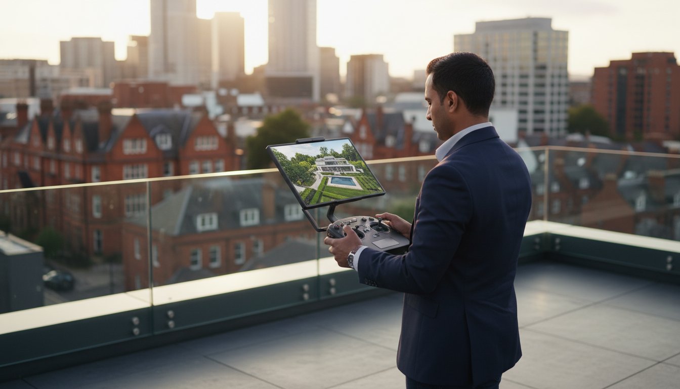
Buying the wrong drone for your property business could cost you more than just the hardware; it could cost you thousands in CAA fines and invalidate your commercial liability insurance. It’s a common and expensive pitfall for professionals eager to capture those breathtaking, high-level perspectives that can accelerate a sale. You’re right to believe that high-quality aerial imagery is no longer a luxury but a necessity in a competitive market, but achieving it legally and safely is a complex challenge.
This guide is designed to provide complete operational clarity. We’ll identify the best drone for property photography 2026, breaking down the top models that deliver stunning 4K HDR results without an enterprise-level price tag of over £10,000. More importantly, we’ll demystify the operational requirements, from CAA compliance to insurance, ensuring your investment generates top-quality assets and total peace of mind, not legal headaches.
Key Takeaways
- Understand the key specifications that make models like the DJI Mavic 4 Pro the best drone for property photography 2026, and learn why dual-lens systems are a game-changer.
- Navigate the complexities of UK aviation law by clarifying the essential CAA GVC (General Visual Line of Sight Certificate) requirements for professional property marketing.
- Calculate the true return on investment by weighing the purchase price against the often-overlooked costs of professional training, software, and ongoing maintenance.
- Discover why the hardware is only half the battle and learn how professional post-production transforms raw footage into compelling, high-impact marketing assets.
The State of Property Photography in 2026: Why Quality Matters
The landscape of UK property marketing has been irreversibly altered by drone technology. What was once a luxury for multi-million-pound estates is now a fundamental expectation across the market. Today’s prospective buyers, conditioned by high-definition content in every aspect of their digital lives, no longer see professional aerial photography as a novelty. In 2026, its absence is often perceived as a sign of an incomplete or poorly managed listing.
To understand the cinematic potential and technical considerations involved, the following guide offers valuable insights into modern real estate videography:
This shift is backed by compelling data. A 2025 market analysis by Zoopla indicated that UK property listings incorporating professional aerial video see a 43% higher click-through rate from initial searches. More importantly, these properties experience an average reduction in ‘time on market’ of up to 22%. The reason is simple: aerial views provide an unparalleled sense of scale, context, and desirability that ground-level shots cannot replicate. They immediately answer buyers’ key questions about a property’s boundaries, garden size, orientation, and relationship to its neighbours.
This elevated standard is driven by advancements in sensor technology. The 1/2.3-inch sensors common in consumer drones just a few years ago are now obsolete for high-end work. The best drone for property photography 2026 will feature at least a 1-inch or Micro Four Thirds sensor. These larger sensors capture far more light and data, producing images with the wide dynamic range needed to show detail in both the bright sky and the shadowed eaves of a building simultaneously, eliminating the amateurish, washed-out look of older equipment.
Visual Standards for 2026 Real Estate
The standard has shifted decisively. 4K High Dynamic Range (HDR) video is now the absolute baseline for online listings, while 8K still photography is essential for premium print marketing and for allowing digital users to zoom into details without image degradation. Submitting grainy or poorly composed drone shots for a property valued over £750,000 can actively damage the brand of the estate agent and the perceived value of the listing itself. A skilled pilot doesn’t just capture a building; they tell its story, revealing its context within the neighbourhood. This practice is a sophisticated evolution from the early history of aerial photography, now focused on creating a compelling lifestyle narrative that sells not just a house, but a location.
Commercial vs. Residential Requirements
While residential photography focuses on emotional appeal, commercial property requirements are far more data-driven. A commercial developer, construction firm, or facilities manager requires actionable intelligence, not just a pretty picture for a brochure. This is where professional drone services diverge into technical operations, moving from marketing into ‘Data Collection Surveys’. These CAA-regulated flights use specialised payloads and software for:
- Photogrammetry Surveys: Creating centimetre-accurate 3D models of sites and structures for planning.
- Topographical Mapping: Generating detailed land contour maps for development and architectural design.
- Construction Progress Monitoring: Providing key stakeholders with verifiable visual data on project milestones.
Top 3 Drones for Property Photography: 2026 Technical Breakdown
Selecting the optimal drone for property photography is no longer about simply getting a camera in the air. For 2026, the decision hinges on the specific application, from residential marketing to complex commercial surveys. The market leader, DJI, offers a tiered range of professional aircraft, each engineered for distinct outcomes. Understanding the technical differences is paramount to delivering top-quality, legally compliant aerial imagery that provides a genuine return on investment.
Here we provide a technical breakdown of the three models that define the professional landscape, helping you identify the best drone for property photography 2026 for your specific commercial needs.
The Premium Choice: DJI Mavic 4 Pro
For high-end residential property marketing, the DJI Mavic 4 Pro remains the gold standard. Its primary advantage is the Hasselblad camera system, built around a Micro Four Thirds (MFT) sensor. This larger sensor captures significantly more light and data than the 1-inch sensors found in prosumer models, resulting in superior dynamic range and low-light performance. This is critical for capturing those coveted “golden hour” shots with deep, rich colours and minimal noise. The ability to shoot in 10-bit D-Log M provides immense flexibility in post-production, allowing for precise colour grading to match a client’s branding.
Its compact, sub-900g airframe and advanced omnidirectional obstacle avoidance make it perfect for navigating the tight confines of urban property shoots. Operating in congested areas, such as the dense residential streets of Birmingham and the West Midlands, demands not only pilot skill but also strict adherence to UK drone regulations, and the Mavic 4 Pro’s safety features provide an essential layer of risk mitigation.
- Pros: Unmatched image quality in its class, exceptional low-light capability, and excellent portability for rapid deployment.
- Cons: Lacks a mechanical shutter, making it less suitable for high-precision photogrammetry work where geometric accuracy is vital.
The Versatile Contender: DJI Air 3S
The DJI Air 3S carves out its niche with a powerful dual-lens system that is a genuine game-changer for creative property shots. While its main wide-angle camera features a capable 1/1.3-inch sensor, the inclusion of a 3x medium telephoto lens (a 70mm equivalent) unlocks the power of lens compression. This effect subtly flattens the perspective, making properties appear more majestic and allowing features like landscaped gardens or swimming pools to be framed without the wide-angle distortion that can plague single-lens drones. For agents looking to create a more cinematic and visually compelling portfolio, the Air 3S offers creative flexibility that was previously only available on much larger, more expensive platforms.
The Commercial Workhorse: DJI Mavic 3 Enterprise (M3E)
When the mission shifts from marketing to data-gathering, the DJI Mavic 3 Enterprise is the essential tool. Its key differentiator is a wide-angle camera equipped with a mechanical shutter. This is non-negotiable for professional survey work, as it eliminates the rolling shutter distortion that can corrupt data, ensuring every photograph is geometrically precise for creating crisp, blur-free orthomosaic maps and 3D models.
Furthermore, the M3E’s compatibility with an RTK (Real-Time Kinematic) module provides centimetre-level positioning accuracy. This is the standard required for professional land surveying, boundary mapping, and construction progress monitoring. For more advanced applications, the M3T variant includes a 640×512 resolution thermal camera, ideal for conducting building heat-loss inspections and identifying roof moisture ingress. Understanding which tool is right for your project is key, and our professional commercial drone services are tailored to these specific, data-critical needs.

UK Drone Regulations & Safety: The ‘Hidden’ Cost of 2026 Compliance
Selecting the hardware is only the first step. The true cost and value of professional aerial imaging are rooted in legal compliance and operational safety. For property professionals, overlooking these factors introduces significant financial and reputational risk. The impressive capabilities of the best drone for property photography 2026 are rendered useless, and even dangerous, without a certified pilot operating within the strict framework set by the UK’s Civil Aviation Authority (CAA).
Hiring an uncertified pilot simply to save a few hundred pounds is a high-risk gamble. In the event of an incident, the liability can fall directly on the commissioning business, leading to potential fines that, under the Air Navigation Order 2016, can be unlimited. This section unpacks the non-negotiable legal and insurance requirements that define professional drone services in the UK.
Navigating the Civil Aviation Authority (CAA)
Since the major regulatory overhaul on 31st December 2020, UK drone operations fall into distinct categories. The ‘Open’ category is for low-risk, recreational flights away from people. Commercial property photography, especially in urban areas, almost always falls into the ‘Specific’ category. This category requires the drone operator to hold an Operational Authorisation from the CAA, for which the General Visual Line of Sight Certificate (GVC) is the standard qualification. This certification, which replaced the older PfCO, proves a pilot has the theoretical knowledge and practical skill to operate safely, manage risk, and understand complex aviation principles. For operations in congested areas like central Birmingham or the dense urban centres of the West Midlands, a GVC isn’t just a recommendation; it’s a fundamental requirement for legal flight.
Insurance and Risk Management
A professional pilot’s commitment to safety extends far beyond their qualifications. Before a drone even leaves its case, a meticulous process of risk management begins. This is a key differentiator that hobbyist insurance simply doesn’t cover. Standard recreational policies are not valid for any form of commercial work, or ‘for valuable consideration’.
- Commercial Liability: The industry standard for professional operators is a minimum of £5 million in commercial liability insurance, compliant with regulation EC785/2004. Always ask to see a current certificate.
- Pre-Flight Risk Assessment: A certified pilot will conduct a detailed site survey and risk assessment, identifying potential hazards like air traffic, public footpaths, power lines, and data privacy concerns. This isn’t just paperwork; it’s a strategic plan to ensure a safe and successful shoot.
- Brand Protection: An incident with an uninsured or uncertified pilot can cause irreparable damage to your brand. For added peace of mind, partnering with a fully compliant operator demonstrates due diligence and protects your business from legal entanglements and negative press. The expanding scope of commercial drone applications from simple photography to complex data-gathering makes this professional oversight more critical than ever.
Ultimately, the investment in a GVC-certified and properly insured drone pilot is an investment in certainty. It ensures your property marketing is not only visually stunning but also legally sound and professionally executed.
Buy vs. Hire: Calculating the ROI of Professional Drone Services
For many estate agencies, the question isn’t if they should use aerial imagery, but how. The temptation to purchase a drone in-house is strong, but a simple cost comparison between hardware and a day rate is dangerously misleading. A true Return on Investment (ROI) calculation reveals the extensive hidden costs and operational burdens of an in-house programme. The decision to buy or hire directly impacts your time, legal compliance, and the final quality of your property listings.
An in-house pilot doesn’t just fly a drone. They become a dedicated aviation manager, video editor, and legal compliance officer. Outsourcing to a professional service liberates your team from these roles, saving, on average, over 20 hours of non-core work per property. This includes pre-flight risk assessments, airspace checks, travel, on-site capture, data processing, and professional-grade editing. That’s time your agents can reinvest directly into sales and client management.
The Real Cost of In-House Drone Operations
The initial investment for what’s considered the best drone for property photography 2026 can range from £2,000 to over £10,000 for a commercial-grade system. For those looking to purchase, online retailers like DroneHundred offer a range of professional models. This capital expenditure is just the entry fee. The ongoing operational costs quickly eclipse the initial purchase price, creating a significant financial drain that a simple service fee avoids. A comprehensive breakdown includes:
- Training & Certification: A commercial operator in the UK must hold a CAA-issued General Visual Line of Sight Certificate (GVC). The initial training and exam costs approximately £1,000, with ongoing professional development required to stay current with evolving 2026 regulations.
- Commercial Insurance: Public Liability Insurance compliant with EC 785/2004 is a legal requirement for commercial drone work. Policies for new operators typically start at £750 per annum.
- Software Subscriptions: Professional output demands professional tools. Monthly subscriptions for software like Adobe Creative Cloud for video editing (£51.98/month) and Pix4D for 3D mapping (£280/month) are standard.
- Maintenance & Depreciation: A commercial drone depreciates rapidly. A £5,000 drone today may be worth less than £2,500 in 24 months. Factoring in battery replacements (£170 each) and potential repairs adds hundreds more to the annual cost.
The Professional Advantage
Partnering with a certified drone services provider offers far more than just aerial footage; it provides operational excellence and guaranteed quality control. A pilot with a CAA GVC isn’t just a hobbyist. They are a trained aviator, capable of conducting detailed risk assessments and securing permissions to fly in congested areas or near flight restriction zones, unlocking perspectives an untrained operator legally cannot achieve.
This expertise extends beyond the flight itself. Professional services deliver reliability. We handle all project management, from monitoring weather patterns with advanced forecasting tools to ensure optimal lighting, to managing all CAA-required documentation for full legal compliance. For added peace of mind, this process ensures every listing, whether it’s a single home in Birmingham or a portfolio of properties across the UK, is captured and produced to the exact same high-quality brand standard. You don’t just hire a pilot; you gain access to a full team of post-production experts who transform raw data into breath-taking, cinematic property tours. To ensure your listings benefit from this professional edge and achieve maximum market impact, contact our team for a professional consultation.
Elevating the Results: Beyond the Raw Drone Footage
Capturing high-resolution images and 4K video is only the first step. The true value in professional aerial property marketing is unlocked in post-production, where raw data is transformed into compelling assets. A top-tier drone provides the potential, but it’s the expert handling of that footage and data that delivers a tangible return on investment. The best drone for property photography 2026 isn’t just about the hardware; it’s about the entire ecosystem of services that turns aerial captures into breath-taking, actionable results.
At Impact Aerial, our process is meticulously designed to maximise the potential of every flight. From initial consultation and CAA-compliant flight planning to the final polished edit, we provide an end-to-end professional service. We understand that turning raw footage into a high-quality marketing film or a precise technical survey requires a distinct set of skills that goes far beyond piloting the drone itself.
Cinematic Editing for Property
The difference between raw drone footage and a finished property film is stark. Raw video, often shot in a flat colour profile to retain maximum data, can appear dull and uninviting. Our professional post-production process involves several critical stages to create a polished, engaging asset:
- Colour Grading and Correction: We meticulously adjust colours to ensure the property looks its absolute best, making lawns appear lush and skies a vibrant blue. For shoots on overcast days, a common reality in the UK, we can perform professional sky replacements to present the property in its most appealing light.
- Branding and Information: We integrate your company branding, logos, and contact details directly into the video. By adding a professionally licensed music track and clear call-to-actions, we transform a simple fly-over into a powerful marketing tool that actively generates leads.
Looking ahead to 2026, optimising for social media is non-negotiable. With over 70% of property searches starting on mobile devices, vertical video is essential. We re-frame our 4K footage for platforms like Instagram Reels and TikTok, creating dynamic, fast-paced edits in a 9:16 aspect ratio that are proven to hold viewer attention and increase share rates by up to 25%.
Technical Data and Virtual Tours
Beyond marketing, the data-gathering capabilities of modern drones offer immense value. We use advanced photogrammetry techniques to create assets that give potential buyers and investors unparalleled insight into a property before they ever set foot on site. This includes integrating high-resolution aerial shots into 3D virtual tours like Matterport, allowing a user to seamlessly transition from a “dollhouse” overview of the entire property and its grounds directly into an internal walk-through.
For commercial clients, this data becomes a critical tool for surveying and inspection, delivering significant cost savings. Our services include:
- Roof and Building Inspections: Safely identify structural issues, water ingress, or damage without the cost and risk of scaffolding, reducing inspection costs by an average of 60%.
- Thermal Assessments: Using specialised thermal sensors, we can pinpoint areas of heat loss in a building’s envelope, providing data that can lead to energy efficiency improvements saving a business thousands of pounds annually.
- Large-Scale Surveys: We conduct detailed surveys for large sites, including commercial developments and PV Solar Farms, providing accurate data for planning and maintenance.
Leveraging the full spectrum of aerial capabilities, from cinematic video to precise technical data, is what separates an amateur operator from a professional partner. To discover how our comprehensive services can benefit your property portfolio, contact Impact Aerial for a professional property consultation.
Elevate Your 2026 Property Listings with Professional Aerial Imagery
Choosing the right aerial strategy for your properties in 2026 goes far beyond picking a drone from a list. It’s about understanding that superior image quality, strict adherence to UK drone regulations, and a positive return on investment are all interconnected. While owning the equipment seems appealing, the hidden costs of CAA compliance, insurance, and maintenance can easily surpass £2,000 per year. Navigating these complexities is crucial to successfully leveraging the best drone for property photography 2026.
Instead of managing the hardware and legalities yourself, partner with a trusted specialist. At Impact Aerial, our CAA GVC Certified pilots provide complete peace of mind with £5m in commercial liability insurance. As the leading specialists in Birmingham and the West Midlands, we deliver not just raw footage, but a full suite of services including expert post-production and immersive virtual tours. Let us handle the technical details so you can focus on selling.
Ready to make your listings stand out from the competition? Book Your Professional Property Drone Shoot with Impact Aerial and see the difference true expertise makes.
Frequently Asked Questions
Do I need a license to take drone photos of my own property listings in the UK?
Yes, you do. If you’re using drone photos for any commercial purpose, including marketing your own property listing, it’s considered ‘material consideration’ by the UK’s Civil Aviation Authority (CAA). This requires the operator to hold a relevant qualification, such as an A2 Certificate of Competency (A2 CofC) or a General Visual Line of Sight Certificate (GVC), and to have appropriate commercial insurance. Operating without these can result in significant legal penalties.
What is the best drone for real estate photography in 2026?
The best drone for real estate photography in 2026 is one that offers a superior camera sensor and robust flight stability, such as the DJI Mavic 3 Pro. Its triple-camera system provides exceptional versatility for capturing wide establishing shots and detailed telephoto images. For professionals seeking the best drone for property photography 2026 with a focus on value, the DJI Air 3’s dual-camera system also delivers professional-grade 48MP photos and stable 4K video, making it a leading contender.
How much does a professional drone property shoot cost in the UK?
A professional drone property shoot in the UK typically costs between £250 and £600. The final price is determined by the property’s size, location, and the required deliverables. A standard package for a residential property, including 10-15 high-resolution stills, will be at the lower end of that range. Larger commercial sites or projects requiring 4K video with extensive editing will naturally command a higher fee, often exceeding £500 due to the increased operational complexity.
Can drones fly in rain or high winds for property surveys?
No, professional drones cannot be operated safely in rain or high winds. Most commercial drones are not waterproof, and moisture can cause catastrophic failure to the electronic systems. Furthermore, CAA operational guidelines and manufacturer limits restrict flight in high winds, typically above 22 mph. To ensure flight stability, client safety, and the acquisition of high-quality data, all professional drone operations are rescheduled if adverse weather conditions are present.
What insurance does a drone pilot need for commercial work?
For any commercial work in the UK, a drone pilot must hold a specialist insurance policy that is compliant with regulation EC 785/2004. This policy must include public liability insurance, with the industry standard being a minimum coverage of £1 million. For added peace of mind, most reputable professional services carry higher indemnity levels, often between £5 million and £10 million, especially when operating on sensitive or large-scale commercial sites. Always ask to see a current insurance certificate.
How long does a typical drone property shoot take?
A typical drone shoot for a standard residential property takes approximately 60 to 90 minutes on-site. This time includes conducting essential pre-flight risk assessments and safety checks, followed by 20-40 minutes of active flight to capture all the required imagery. Larger commercial properties or rural estates can require 2-3 hours on-site to ensure full coverage. This timeframe does not include the off-site post-production time needed for photo and video editing.
What is the difference between a 4K and 8K drone for property?
The key difference is video resolution; an 8K drone captures four times the number of pixels as a 4K drone, offering far greater detail. This allows for significant cropping or digital zooming during post-production without a noticeable loss in quality. However, for over 95% of property marketing applications, 4K resolution provides an optimal balance of high-quality visuals and manageable file sizes. It’s perfectly suited for online property portals, websites, and social media.
Is it better to buy a DJI Mini or a Mavic for real estate?
For professional real estate photography, a DJI Mavic series drone is definitively the better choice over a DJI Mini. While the Mini is an excellent sub-250g drone, the Mavic series (like the Mavic 3) features significantly larger camera sensors, providing superior dynamic range and low-light performance. Mavics also offer better wind resistance and more advanced flight modes, which are critical for achieving the high-quality, stable, and safe results required in a commercial environment.