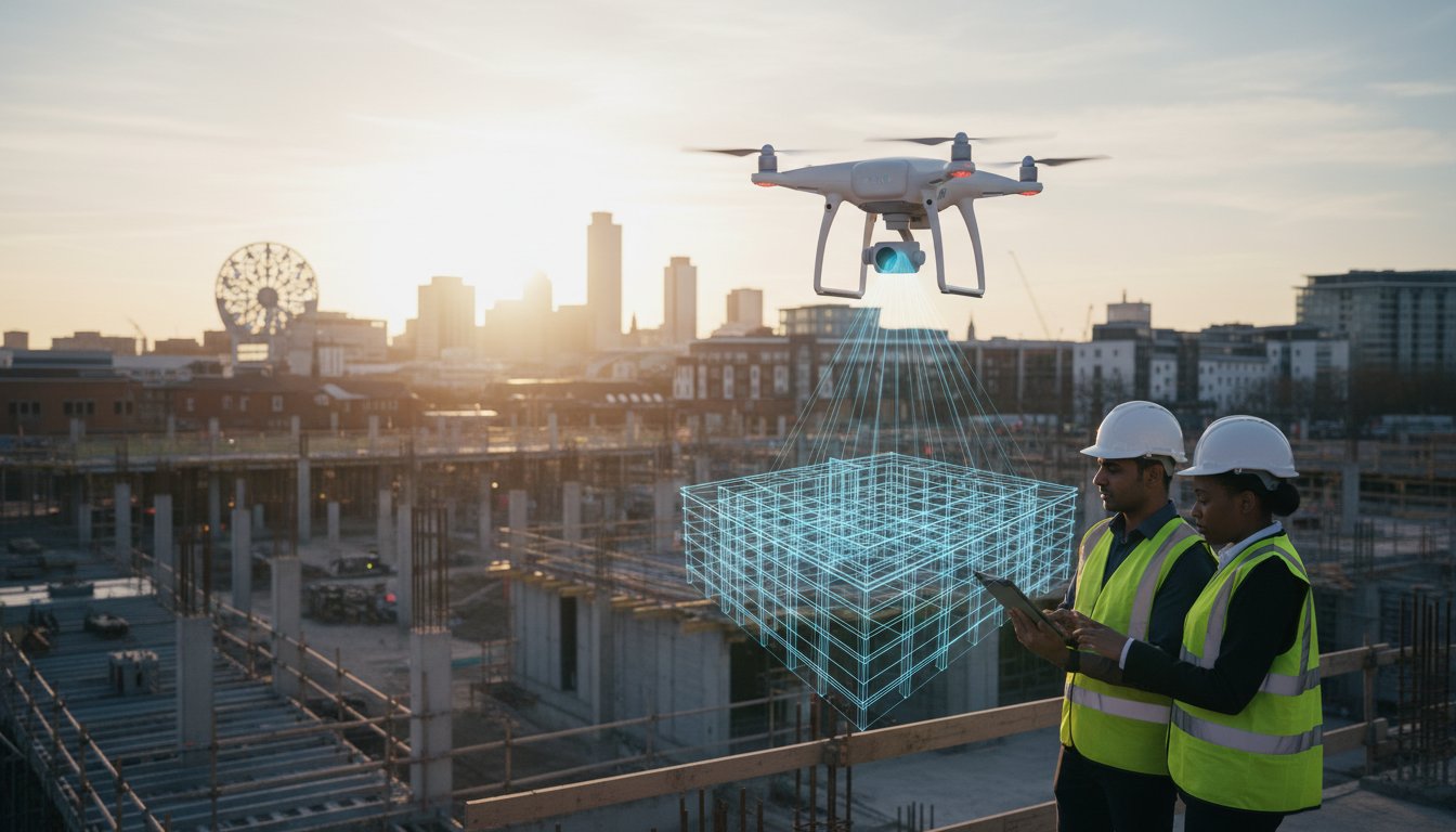
In the demanding landscape of UK construction, relying on traditional, manual site inspections is becoming increasingly inefficient and hazardous. The inherent safety risks, costly delays, and potential for stakeholder disputes arising from inaccurate progress reports can compromise even the most well-managed project. This is where the transformative capabilities of professional drone construction site monitoring provide a definitive advantage, offering a safer, faster, and remarkably more precise method for project oversight.
However, successfully integrating this technology requires more than simply launching a drone. It demands a thorough understanding of current UK aviation law, data processing for accurate 3D models and BIM integration, and strategic implementation. This comprehensive 2026 guide is engineered to provide you with that mastery. We will navigate the critical technical, regulatory, and strategic aspects, giving you the confidence to achieve real-time visual updates and full regulatory peace of mind on every project.
Key Takeaways
- Understand how drone data has evolved from simple progress photos to fully integrated data streams for enhanced project transparency.
- Discover the critical differences between the old PfCO and current CAA GVC standard to avoid the significant liabilities of hiring uncertified pilots.
- Learn when to use high-resolution aerial photos for visual updates versus when to deploy 3D photogrammetry for precise surveying and data analysis.
- Implement a strategic flight schedule for your drone construction site monitoring by aligning missions with key project milestones to maximise return on investment.
The Evolution of Drone Construction Site Monitoring in 2026
In 2026, the term drone construction site monitoring has evolved far beyond its origins of capturing simple aerial progress photos. It now represents the integration of high-fidelity data streams into the core of project management. The modern approach involves deploying sophisticated unmanned aerial vehicles (UAVs) to create a dynamic, data-rich overview of a site’s entire lifecycle. This shift from periodic reactive site visits to proactive, data-driven oversight has reached a tipping point in the UK construction sector, driven by demands for greater efficiency, stringent safety compliance, and indisputable project documentation.
To see how this technology is being applied for critical tasks like safety inspections, watch this insightful video:
This “drone-first” methodology is no longer a niche advantage but a competitive necessity. The ability to generate a high-resolution visual audit trail using 4K High Dynamic Range (HDR) imagery provides project managers, stakeholders, and insurers with an unambiguous record of progress and quality. In the event of disputes or litigation, this clear, time-stamped evidence proves invaluable, protecting contractors from unsubstantiated claims and providing clarity for insurance purposes.
From Visual Progress to Digital Assets
The crucial distinction in 2026 lies between “taking photos” and “creating digital assets.” A simple photograph shows a moment in time, but a drone-captured dataset is a geotagged, measurable digital asset. These assets form a permanent record, crucial for documenting sub-surface works like foundations and utility installations before they are covered. This historical data provides an irrefutable timeline, preventing costly disputes and delays during the final “snagging” phase by offering clear evidence of what was completed, when, and to what standard.
The 2026 Technology Stack: DJI Enterprise and Beyond
The hardware enabling this revolution is more robust than ever. Professional services rely on platforms like DJI Enterprise drones, which offer exceptional stability in the often-challenging high-wind conditions of UK construction sites. For documentation, 4K HDR is now the minimum acceptable standard, ensuring every detail is captured with the clarity required for technical analysis and legal review. This data feeds directly into a project’s Digital Twin, which is a virtual, live, 1:1 replica of the physical construction site, updated with real-time drone data for unparalleled project management.
Regulatory Compliance and Safety: The CAA GVC Standard
In the high-stakes environment of a construction site, cutting corners on aerial data acquisition is a risk no firm can afford. Hiring an uncertified or under-insured drone pilot is not just a breach of regulations; it’s a massive liability that can jeopardise project timelines, budgets, and site safety. For any modern drone construction site monitoring programme, understanding the UK’s stringent aviation laws is the first step toward successful and secure implementation. Project managers must be aware that the legal landscape has evolved, with the Civil Aviation Authority (CAA) now mandating a higher standard of pilot competence.
Understanding CAA GVC Certification
The General Visual Line of Sight Certificate (GVC) is the professional standard required for most commercial drone operations in the UK, superseding the older PfCO qualification. This certification is not a simple formality; it confirms a pilot has passed rigorous theoretical exams and a practical flight assessment, proving their competence in managing operations safely. This training is critical on a dynamic construction site, enabling pilots to conduct thorough risk assessments and plan flights that safely navigate airspace near active tower cranes, heavy machinery, and personnel. This adherence to the official CAA operational guidance provides the essential peace of mind that comes from using a fully vetted and compliant operator.
Insurance and Liability on Active Sites
Standard public liability insurance is wholly insufficient for commercial drone operations. A professional drone services provider must hold specialist EC 785/2004 compliant commercial liability insurance. For work on major construction projects, particularly in congested areas like the West Midlands, a policy of at least £5 million is the industry standard. You can verify a pilot’s credentials and insurance status through trusted directories like the Drone Safe Register. At Impact Aerial, we streamline this process by liaising directly with your Site Manager, providing a complete safety pack with our certification, insurance, and site-specific risk assessment before any flight operations begin.
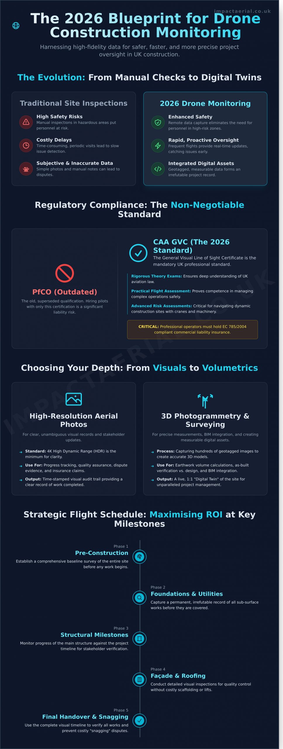
Visual Progress vs. Precision Data: Choosing Your Depth
Effective drone construction site monitoring delivers two distinct, yet complementary, types of output: high-impact visual documentation and survey-grade precision data. Understanding the difference is crucial for unlocking the full potential of aerial intelligence on your project. The choice is not about which is better, but which is right for your immediate objective, whether that’s engaging stakeholders or informing critical engineering decisions.
The Power of High-Resolution Progress Photos
For many project managers, the primary value lies in consistent, high-quality visual updates. Weekly or bi-weekly aerial overflights provide an unparalleled bird’s-eye-view, perfect for investor reports and client meetings. Crisp 4K video footage is invaluable for planning site logistics, tracking plant movement, and enhancing safety briefings. Furthermore, this compelling visual record serves as a powerful marketing asset, showcasing your capabilities for future project bids and tenders.
Technical Data: Photogrammetry and Volumetrics
When precision is paramount, simple photography evolves into sophisticated data gathering. Photogrammetry is the science of turning hundreds of overlapping aerial photos into measurable, geographically accurate 2D maps (orthomosaics) and 3D models. This process, a core component of many Drone applications in construction, allows for a level of insight far beyond the human eye. Key applications include:
- Volumetric Calculations: Accurately measure stockpile volumes of aggregate or earthworks in minutes, achieving accuracy levels often exceeding 98-99% compared to traditional methods.
- Topographic Surveys: Generate detailed topographic data during pre-planning and excavation stages to ensure site work aligns perfectly with design specifications.
Beyond standard imaging, specialised sensors provide deeper analysis. Thermal imaging cameras can detect heat loss from a building envelope, identify water ingress on a flat roof, or flag malfunctioning equipment. The ultimate goal is integration; all this data, from 3D point clouds to thermal maps, can be seamlessly imported into your existing BIM (Building Information Modelling) workflows. This allows for direct as-built versus as-designed comparisons, catching costly deviations early and ensuring the project remains on track, on time, and on budget.
Establishing a Site Monitoring Schedule for Maximum ROI
To truly leverage the power of drone technology in construction, a reactive approach is insufficient. A structured, proactive schedule for drone construction site monitoring is essential for maximising your return on investment. The optimal frequency depends entirely on project complexity, timelines, and stakeholder requirements, transforming raw data into actionable intelligence that drives efficiency and mitigates risk.
Setting the Monitoring Frequency
Aligning flight missions with your project’s pace ensures you capture meaningful progress and identify issues before they escalate. At Impact Aerial, our professional services are tailored to your specific needs, but a typical framework includes:
- Weekly Flights: The gold standard for fast-paced vertical construction, such as commercial high-rises or complex industrial facilities. This high frequency allows for granular progress tracking against the schedule, early detection of deviations from plans, and accurate stockpile management.
- Monthly Overviews: Ideal for long-term infrastructure projects like new road layouts or large-scale housing developments. These flights provide a comprehensive “big picture” overview, perfect for client updates and validating major phase completions.
- Ad-Hoc Inspections: Deployed rapidly in response to specific events. This includes post-storm inspections to assess damage, verifying the completion of critical works like foundation pouring before sign-off, or investigating a site incident with indisputable visual evidence.
Data Distribution and Stakeholder Access
The high-quality data gathered is only effective when it reaches the right people in a usable format. We facilitate seamless collaboration by distributing data via secure, cloud-based platforms. This allows remote architects to interact with detailed 3D models and engineers to overlay CAD drawings onto up-to-date orthomosaic maps. For non-technical stakeholders, we produce clear, “investor-ready” PDF reports that visually communicate progress against key milestones. For a deeper dive into the data outputs, see The Ultimate Guide to Commercial Drone Surveys.
Calculating the Cost-Offset vs. Traditional Man-Hours
A professional drone survey programme delivers significant and demonstrable cost savings. A traditional land surveyor may require a full day on-site, costing upwards of £600, to capture a limited number of data points. In contrast, a CAA GVC Certified drone pilot can survey an entire site in a fraction of the time, drastically reducing billable man-hours and minimising safety risks associated with personnel navigating an active site. This efficiency not only cuts direct survey costs but also prevents expensive rework by identifying discrepancies between as-built conditions and design plans weeks earlier than traditional methods, providing you with added peace of mind.
Why Impact Aerial is the UK Partner for Site Monitoring
Choosing the right partner for your project oversight is critical. While many operators can fly a drone, Impact Aerial delivers a comprehensive, end-to-end professional service. Based in Birmingham and the West Midlands, we offer full national UK coverage, combining local expertise with the capacity to manage projects of any scale. We understand that effective drone construction site monitoring is about more than just data; it’s about delivering clear, actionable intelligence and breath-taking end results that serve both engineering precision and marketing impact.
The Impact Aerial difference lies in our commitment to quality at every stage, starting with our equipment. We exclusively operate commercial-grade DJI Enterprise drones. This isn’t just a technical detail—it means superior reliability in challenging site conditions, higher resolution sensors for more accurate data capture, and advanced safety features. For added peace of mind, this investment in leading technology ensures the data we gather is consistently precise, secure, and fit for purpose, whether for photogrammetry or a high-impact promotional film.
Our Process: From Consultation to Delivery
Our methodical process guarantees safety, compliance, and minimal disruption. It begins with a detailed site assessment and managing all regulatory clearances with the CAA. On-site, our GVC certified pilots execute the flight plan with precision. The mission concludes with professional post-production, where raw data is processed into clear, concise reports, 2D maps, or 3D models tailored to your project’s specific requirements.
Tailored Solutions for Property and Infrastructure
Every construction project has unique demands. We create customised data packages to meet the needs of different departments—from weekly progress reports for stakeholders to thermal imaging for building inspectors. For a recent large-scale residential developer in the West Midlands, we provided a dual-purpose solution that tracked build progress for the project managers while supplying the marketing team with compelling visuals. Let us design a package for you. Contact Impact Aerial for a tailored site monitoring quote and discover how our services can benefit your project.
Beyond aerial footage, many developers also leverage their vehicle fleets as mobile marketing assets. For firms looking to enhance their brand visibility on and off the construction site, it’s worthwhile to explore Full Van Wraps as a way to project a professional image across all company vehicles.
Partner with the UK’s Leading Drone Experts for 2026 and Beyond
As we look towards 2026, it’s clear that drone construction site monitoring is no longer an optional extra but a fundamental component of efficient project management. The key to success lies in navigating the evolving regulatory landscape, such as the CAA GVC standard, and strategically choosing between high-resolution visual tracking and precision data to maximise your project’s ROI.
Choosing a fully-certified and insured partner is paramount for compliance and safety. Based in Birmingham with national coverage, Impact Aerial provides that professional assurance. Our pilots are all CAA GVC Certified, and for added peace of mind, every operation is backed by £5m in commercial liability insurance, ensuring your project is in expert hands.
Ready to enhance your project’s safety, efficiency, and data accuracy? Request a Quote for Professional Construction Site Monitoring today and discover how our expert services can elevate your oversight. Let’s build the future of construction, together.
Frequently Asked Questions About Drone Construction Monitoring
Do I need a license to use a drone for construction site monitoring in the UK?
Yes, any drone flight conducted for commercial purposes, including construction monitoring, legally requires the operator to hold current Civil Aviation Authority (CAA) certification. The standard for professional operators is the General VLOS Certificate (GVC). This ensures the pilot is proficient in flight safety, operational procedures, and UK air law. Always verify your provider is CAA-certified and insured before commencing any work on your site.
How much does professional drone construction monitoring cost in 2026?
In 2026, professional drone services for construction sites typically range from £500 to over £1,500 per day. The final cost depends on the project’s complexity, the required data outputs (e.g., 4K video vs. detailed 3D models), and the frequency of the flights. A simple visual progress report will be at the lower end, while a comprehensive topographical survey requiring significant data processing will command a higher fee. Most providers offer bespoke project-based pricing.
Can drones fly in rain or high winds on a construction site?
Most commercial drones are not designed to operate in rain, as moisture can damage sensitive electronics and compromise flight safety. Operations are also typically grounded in high winds, usually above 25 mph, to ensure stable flight and prevent accidents. A professional operator will always prioritise safety and data quality, and will reschedule flights if weather conditions are deemed unsuitable, in line with their operational safety case and risk assessment.
What is the difference between a drone survey and progress monitoring?
A drone survey is a technical, data-gathering exercise focused on high-accuracy measurements. Using photogrammetry, it produces measurable outputs like topographic maps, 3D point clouds, and volumetric calculations for earthworks. In contrast, progress monitoring is primarily a visual tool. It uses high-resolution photos and videos captured from consistent waypoints over time to create a visual record of site development, track milestones, and enhance stakeholder communication.
How long does it take to receive the data after a drone flight?
The turnaround time for data depends entirely on the required deliverables. Standard high-resolution photographs and raw video footage can often be delivered within 24 hours of the flight. However, more complex data sets that require extensive processing, such as orthomosaic maps, detailed 3D models, or topographical surveys, typically require 48 to 72 hours to process, stitch, and quality-check before being delivered to your project team.
Is drone monitoring safe to use around active cranes and personnel?
Yes, when conducted by a qualified and experienced pilot, professional drone construction site monitoring is exceptionally safe. Certified operators are required to complete detailed pre-flight risk assessments and establish clear communication protocols with the site manager. This includes defining flight paths, creating exclusion zones, and scheduling flights during periods of low activity to ensure the complete safety of all personnel, machinery, and active cranes on site.
What insurance coverage should a professional drone pilot have?
A professional drone operator must hold specialist commercial Public Liability Insurance that is compliant with regulation EC 785/2004. For added peace of mind, you should ensure your provider has coverage of at least £5 million, with many leading operators carrying £10 million. This insurance specifically covers aviation-related risks associated with commercial drone operations, protecting your personnel, property, and assets throughout the flight mission.
Can drone data be integrated into BIM software like Revit or AutoCAD?
Absolutely. This is one of the most powerful applications of drone survey data. Outputs such as high-density 3D point clouds (.LAS, .LAZ) and detailed 3D mesh models (.OBJ) are designed for seamless integration into leading BIM and CAD software platforms. This allows architects, engineers, and project managers to overlay as-built data against design plans in programs like Revit or AutoCAD, enabling precise progress verification and clash detection.