Is drone surveying just a high-tech gimmick, or is it a genuinely transformative tool for professional projects? If you’re exploring aerial surveying, you likely have questions about data accuracy, compliance with complex UK regulations, and crucially, how to distinguish a certified expert from an enthusiastic hobbyist. These are valid concerns in a rapidly advancing industry, where the quality of your data and the legality of its acquisition are paramount.
The reality is that a professional drone surveyor offers a revolutionary approach to data gathering, delivering unparalleled accuracy, safety, and efficiency for projects in construction, land management, and infrastructure. This comprehensive guide is designed to provide clarity and peace of mind. We will demystify the role of a drone surveyor, detail the key benefits for your business, and explain technical outputs like orthomosaics and point clouds in plain English. Most importantly, we’ll equip you with the essential knowledge to choose a fully qualified, CAA-certified, and insured expert, ensuring you receive top-quality, actionable data you can rely on.
What is a Drone Surveyor and How Do They Differ from Traditional Surveyors?
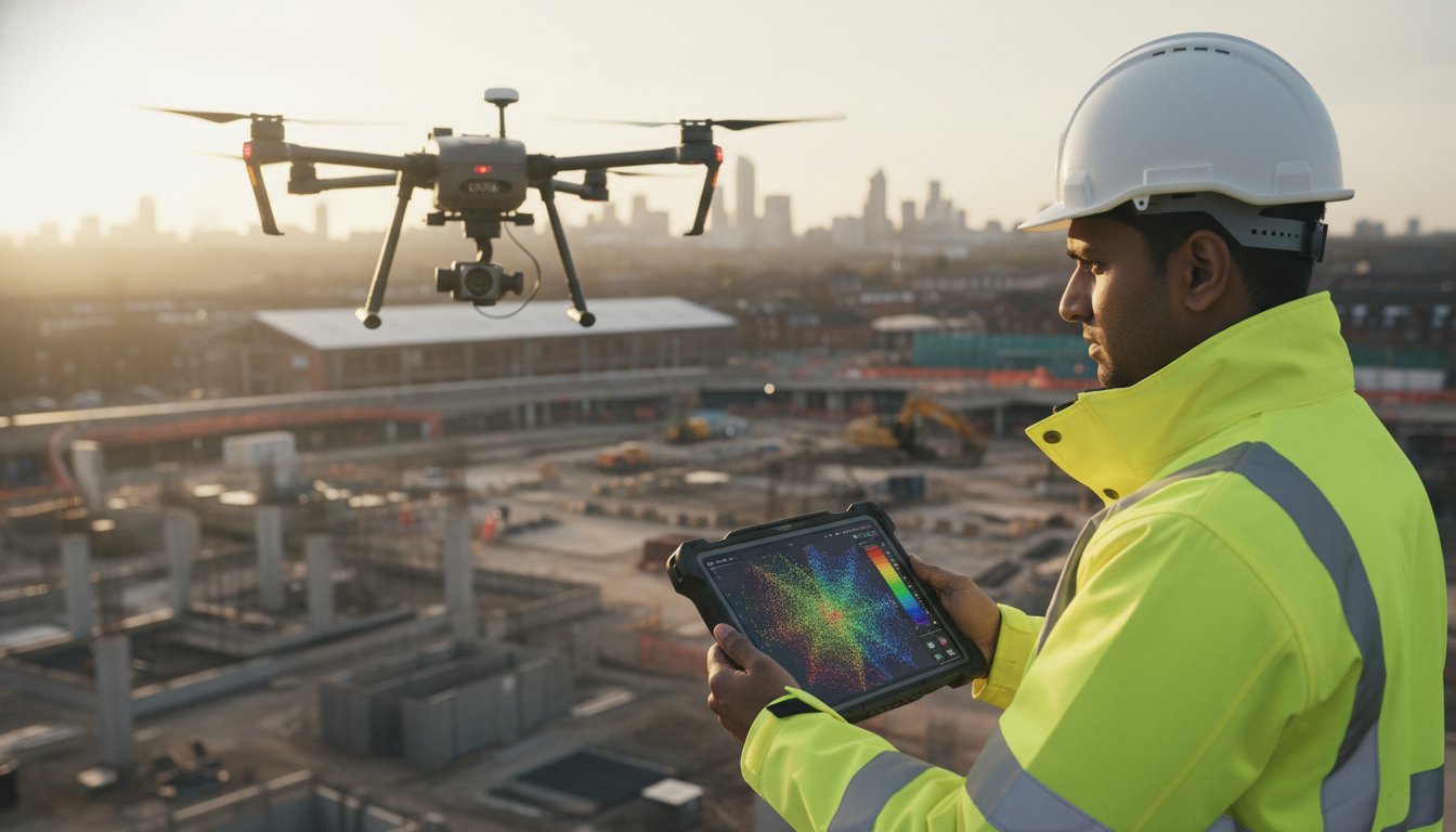
A drone surveyor is a certified professional who utilises Unmanned Aerial Vehicles (UAVs) to conduct high-precision surveys and inspections. This role is a sophisticated blend of expert piloting, governed by Civil Aviation Authority (CAA) regulations, and deep expertise in geospatial data analysis. Far more than just a pilot, a professional drone surveyor is a data specialist whose primary objective is to capture vast amounts of high-resolution aerial data, which is then processed to create highly accurate 2D orthomosaic maps, 3D digital elevation models, and detailed asset reports.
To see this advanced data-gathering capability in action, the video below showcases a LiDAR drone project:
The Role of a UAV (Unmanned Aerial Vehicle) in Modern Surveying
In modern land and asset management, UAVs serve as advanced data-gathering tools, revolutionising the efficiency and scope of surveying projects. These commercial-grade drones can be equipped with a range of sophisticated sensors-from high-resolution RGB cameras for photogrammetry to thermal sensors for heat-loss analysis and LiDAR for creating precise point clouds. This technology provides a significant advantage in the field of Aerial survey by enabling safe access to difficult or hazardous areas, such as unstable terrain, active construction sites, or tall structures, without putting personnel at risk.
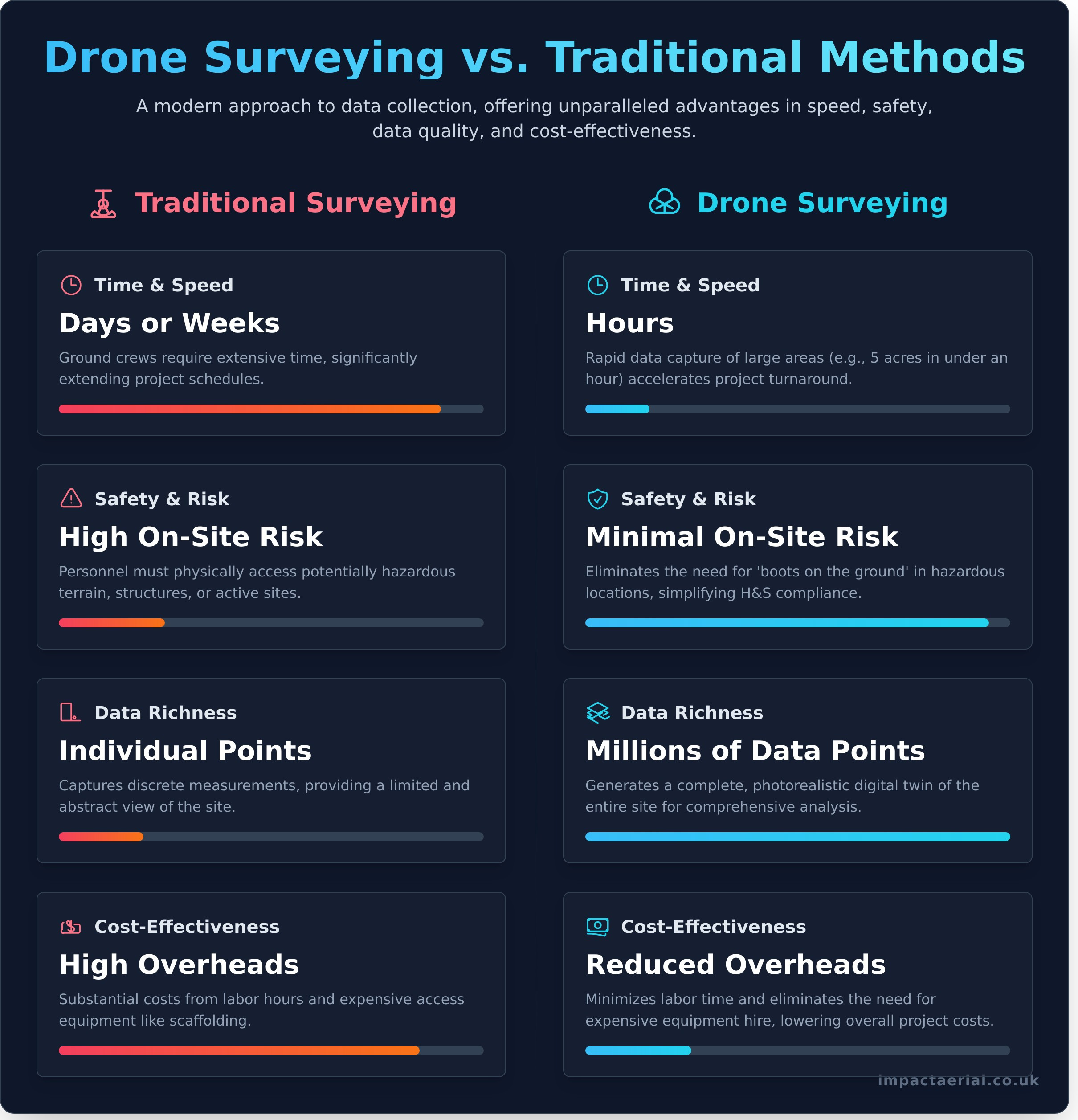
Traditional Surveying vs. Drone Surveying: A Comparison
While both methods aim for accuracy, the operational differences are substantial. Drone surveying offers clear, measurable advantages in key areas, providing tangible benefits for project timelines, safety protocols, and overall costs.
- Time & Speed: A survey that might take a ground crew days or weeks with a total station can often be completed in a matter of hours by a drone, dramatically accelerating project schedules.
- Safety: Drones eliminate the need for personnel to work at height or navigate dangerous terrain. This significantly reduces on-site risk and enhances compliance with health and safety regulations.
- Data Richness: Traditional methods capture individual measurement points. A drone captures millions of data points, creating a complete, photorealistic digital record of the entire site that can be analysed from multiple angles.
- Cost-Effectiveness: By reducing labour hours, minimising equipment hire, and speeding up project turnaround, drone surveying provides a more cost-effective solution for comprehensive data collection.
The Core Benefits of Hiring a Professional Drone Surveyor
Moving beyond traditional surveying methods, the integration of unmanned aerial vehicles (UAVs) offers a transformative approach to data gathering. Engaging a professional drone surveyor provides more than just aerial images; it delivers a strategic advantage grounded in four core benefits: enhanced safety, significant speed and cost efficiencies, and superior data quality. These advantages directly impact your project’s bottom line by reducing risk, accelerating timelines, and enabling more informed, data-driven decisions.
Unmatched Safety and Risk Mitigation
Safety is the most critical advantage of drone surveying. By using a UAV, we eliminate the need for personnel to work at height or access dangerous locations, such as unstable structures, steep embankments, or active industrial sites. This drastically reduces on-site risk and simplifies health and safety compliance documentation. With fewer boots on the ground and minimal site disruption, operations can continue safely while the survey is conducted, ensuring a safer environment for everyone involved.
Significant Time and Cost Savings
The efficiency of aerial data acquisition is unparalleled. A comprehensive survey of a 5-acre site, which could take a traditional team a full day, can often be completed by a drone in under an hour. This rapid data capture leads to faster project turnarounds and quicker decision-making. Furthermore, it eliminates the substantial costs associated with hiring expensive access equipment like scaffolding or cherry pickers, which can run into thousands of pounds and cause significant project delays.
Superior Data Accuracy and Detail
A professional drone survey delivers a far richer dataset than traditional methods. We produce high-resolution orthomosaic maps and detailed 3D point clouds that create a precise digital twin of your site or asset. When combined with Ground Control Points (GCPs), we can achieve centimetre-level accuracy. The level of detail is so reliable that public bodies, such as the NYS Department of Transportation drone program, now use this technology for critical infrastructure management. This creates a complete, auditable snapshot in time, invaluable for progress monitoring, quality assurance, and dispute resolution.
The Drone Surveying Process: From Pre-Flight Planning to Final Deliverables
Contrary to common perception, a professional drone survey is far from a simple point-and-fly operation. It is a meticulous, multi-stage process governed by strict safety protocols and technical precision. A qualified drone surveyor executes a comprehensive workflow designed to ensure accuracy, safety, and the delivery of actionable data. This process is broken down into three distinct phases, from initial consultation to the final handover of assets.
Phase 1: Consultation, Scoping, and Risk Assessment
Every project begins with a detailed consultation to fully understand your objectives, required outputs, and accuracy tolerances. We then conduct a thorough desktop survey, assessing the site for potential hazards and checking all airspace classifications. This is a critical step to ensure full compliance with current UK drone flight regulations as set out by the Civil Aviation Authority (CAA). From this, we create a comprehensive flight plan and a detailed Risk Assessment and Method Statement (RAMS) to guarantee operational safety. We also handle all necessary landowner permissions, providing you with complete peace of mind.
Phase 2: On-Site Data Acquisition
On the day of the survey, our team arrives on-site to establish a secure operational area and conduct final on-site safety checks. For high-accuracy projects, we strategically place Ground Control Points (GCPs), which are surveyed using GPS/GNSS equipment. These points act as a real-world frame of reference for the aerial data. The drone then executes its pre-programmed, automated flight path, capturing hundreds or thousands of high-resolution images with consistent overlap. Throughout the operation, we adhere strictly to our CAA-approved safety protocols and continuously verify data coverage on-site.
Phase 3: Data Processing and Deliverables
Once the data-gathering is complete, the raw imagery is processed using specialist photogrammetry software. This powerful technology stitches the individual photos together to create precise, georeferenced outputs. The final deliverables are tailored to your project’s specific needs and typically include:
- High-Resolution 2D Orthomosaic Maps: A single, scaled top-down map of your site.
- Interactive 3D Point Cloud Models: A detailed digital twin of the surveyed area.
- Digital Elevation/Surface Models (DEM/DSM): To analyse terrain, gradients, and contours.
- Annotated Inspection Reports: Highlighting specific areas of interest or defects.
All data is securely delivered via a dedicated cloud platform for easy access and integration into your existing workflows. See examples of our survey deliverables.
How to Choose a Qualified Drone Surveyor: Key Credentials to Verify
In the rapidly expanding field of aerial surveying, it’s crucial to understand that not every commercial drone operator possesses the skills, qualifications, or equipment to be a professional drone surveyor. Engaging an unqualified operator can lead to inaccurate data, safety risks, and legal complications. To ensure you receive precise, reliable results and protect your project, it is essential to verify a provider’s credentials.
Use the following checklist as a guide to vetting a potential partner. These are not optional extras; they are the non-negotiable standards of a professional, compliant, and trustworthy aerial surveying company.
Essential CAA Certification: The GVC Qualification
In the UK, any drone operator flying for commercial purposes must hold a valid Operational Authorisation from the Civil Aviation Authority (CAA). The pilot’s competency is demonstrated by a General Visual Line of Sight Certificate (GVC), the successor to the old PfCO permission. This qualification proves the pilot has undergone rigorous theoretical training and practical flight assessment, ensuring they operate safely and in full compliance with UK aviation law. Never engage an operator who cannot provide proof of their CAA Operational Authorisation.
Specialist Commercial Drone Insurance
Standard business insurance does not cover commercial drone operations. A professional surveyor must hold a specialist policy that includes adequate public liability cover, typically for a minimum of £5 million. This insurance is vital as it protects your property, assets, and personnel in the unlikely event of an incident. For added peace of mind, always request a copy of their current insurance certificate before any work commences on your site.
Equipment and Industry Experience
The quality of the final survey data is directly linked to the quality of the equipment and the expertise of the operator. A qualified provider will be transparent about their capabilities and be able to demonstrate a proven track record. Key areas to verify include:
- Professional-Grade Drones: Look for the use of commercial drones, such as the DJI Enterprise series, which are designed for high-precision data gathering.
- Relevant Project Portfolio: Ask to see examples of similar survey projects they have completed within your industry, whether it’s construction, property development, or asset management.
- Data Processing Capabilities: Enquire about the photogrammetry and data processing software they use to convert raw aerial data into actionable 2D maps, 3D models, or inspection reports.
- Specialist Sensor Experience: If your project requires it, confirm their experience with advanced sensors like LiDAR for detailed topographical mapping or thermal imaging for building inspections.
By verifying these key credentials, you can confidently select a qualified partner who will deliver accurate data while upholding the highest standards of safety and professionalism. At Impact Aerial, we pride ourselves on our transparency and full compliance with all industry regulations.
Common Applications of Drone Surveying Across UK Industries
The versatility of drone surveying has unlocked significant efficiencies across a diverse range of UK sectors. By delivering high-quality, actionable data faster, more safely, and at a lower cost than traditional methods, aerial surveys are becoming an indispensable tool for project managers, asset owners, and environmental consultants. The applications are extensive, demonstrating how a professional drone surveyor can provide critical insights for almost any large-scale project.
Construction and Engineering
In the fast-paced construction industry, timely and accurate data is paramount. Drone surveys provide a complete digital record of a site, mitigating risks and improving project management from planning to completion. Key applications include:
- Site Progress Monitoring: Regularly capturing high-resolution imagery to track progress against design plans (BIM), identify potential delays, and provide clear updates to stakeholders.
- Volumetric Calculations: Accurately measuring stockpiles and calculating cut and fill volumes for earthworks, ensuring precise material management and cost control.
- As-Built Verification: Creating detailed 3D models and point clouds to verify that construction matches the original design, forming the foundation for a comprehensive digital twin.
- Topographical Surveys: Generating precise land surveys at the start of a project to inform site layout, drainage, and infrastructure planning without extensive ground crew presence.
Property and Building Management
For facilities managers, chartered surveyors, and estate agents, drones offer a revolutionary approach to inspecting and marketing property. They eliminate the need for costly and high-risk manual methods like scaffolding or cherry pickers.
- Roof and Façade Inspections: Safely identifying defects, damage, or maintenance requirements on building envelopes with high-resolution cameras, minimising risk to personnel.
- Thermal Imaging: Using thermal cameras to detect heat loss, pinpoint sources of water ingress, and assess the efficiency of insulation or solar panel installations.
- 3D Models for Marketing: Producing compelling 3D digital models and aerial videography that provide a unique perspective for marketing commercial or residential properties.
- Dilapidation Surveys: Creating a detailed, time-stamped visual record of a property’s condition at the beginning or end of a lease agreement.
Agriculture and Environmental
The ability to cover vast and often inaccessible terrain makes drone surveying an essential service for modern land management and environmental monitoring. The data gathered supports sustainable practices and informed decision-making.
- Crop Health Monitoring: Utilising multispectral sensors to analyse crop health, identify stress areas, and optimise irrigation and fertiliser application for precision agriculture.
- Land Management and Boundary Mapping: Quickly and accurately mapping large estates, farms, and conservation areas to verify boundaries and monitor land use.
- Coastal Erosion and Flood Risk Assessment: Repeatedly surveying coastlines and riverbanks to monitor environmental changes and provide critical data for risk modelling.
From construction sites in Birmingham to coastal management projects in Cornwall, the applications for a certified drone surveyor are continually expanding. If your project requires precise, safe, and efficient data-gathering, aerial technology offers a clear advantage. Discuss your project with our certified surveyors.
Elevate Your Project with a Professional Drone Surveyor
As we’ve explored, the modern drone surveyor has revolutionised data collection across UK industries by delivering unparalleled speed, safety, and detail. This is more than just flying a drone; it’s a comprehensive process involving meticulous planning, precise data acquisition, and the creation of actionable insights. Ultimately, choosing a qualified and certified operator is paramount to guaranteeing the accuracy, compliance, and overall success of your project.
At Impact Aerial, we provide that essential peace of mind. As specialists in construction and property surveys, our team is fully CAA GVC Certified and insured, operating commercial-grade DJI Enterprise drones to capture top-quality data. If you’re ready to leverage the benefits of aerial surveying, we invite you to request a professional drone survey quote from our CAA GVC certified team. Let’s work together to provide the precise, reliable data you need to move forward with confidence.
Frequently Asked Questions
How accurate is a drone survey compared to traditional methods?
When conducted by a certified professional using Ground Control Points (GCPs) and RTK/PPK enabled drones, a drone survey can achieve survey-grade accuracy, often reaching sub-5cm precision. This level of accuracy is comparable to, and in many cases exceeds, traditional ground-based methods. The primary advantages are significant gains in speed, improved safety by removing personnel from hazardous areas, and the ability to capture comprehensive data sets of the entire site.
What happens if the weather is bad on the day of the survey?
Client and public safety is our paramount concern. All flight operations are conducted in strict accordance with CAA regulations, which include limitations on wind speed, precipitation, and visibility. We meticulously monitor weather forecasts leading up to the scheduled survey. If conditions are deemed unsafe or unsuitable for high-quality data capture, we will liaise with you to reschedule the flight for the next suitable day at no additional cost, ensuring the integrity of your project data.
How much does a professional drone survey cost in the UK?
The cost of a professional drone survey in the UK varies based on project specifics. Factors influencing the price include the size and complexity of the site, the required level of accuracy, and the final data deliverables. A small, straightforward topographical survey might start from around £500, while larger projects requiring extensive data processing will be quoted on a case-by-case basis. We provide a detailed, transparent quotation after an initial consultation to understand your exact requirements.
What is the difference between photogrammetry and LiDAR?
Photogrammetry and LiDAR are two distinct data-gathering methods. Photogrammetry involves capturing hundreds of overlapping high-resolution images, which are then processed to create detailed 3D models and orthomosaic maps. LiDAR, however, uses a laser scanner to emit pulses of light, measuring the return time to create a highly accurate point cloud of a surface. While photogrammetry offers photorealistic colour and texture, LiDAR excels at penetrating vegetation and capturing dense topographical data.
How long does it take to receive the final data after the flight?
The on-site flight for data capture is typically completed within a few hours. The more time-intensive stage is post-processing, where the raw data is converted into actionable insights and deliverables. You can generally expect to receive initial processed data, such as a preliminary point cloud or orthomosaic, within 48 hours. The final, fully-analysed survey reports, 3D models, or volumetric calculations are typically delivered within 3 to 7 working days, depending on the project’s complexity.
Can drones be used for indoor surveys?
Yes, drones can be highly effective for indoor surveys, particularly in large or difficult-to-access spaces like warehouses, storage tanks, or structurally compromised buildings. Specialised drones, often equipped with protective cages and advanced sensors like LiDAR, are used for these GPS-denied environments. These operations require a highly skilled pilot and meticulous planning to ensure safety and capture precise data for asset inspection, inventory management, or Building Information Modelling (BIM).
What are the main legal restrictions for flying a survey drone?
In the UK, all commercial drone operations are governed by the Civil Aviation Authority (CAA). Key restrictions include maintaining Visual Line of Sight (VLOS) with the drone, not exceeding an altitude of 400ft (120m), and adhering to strict separation distances from people and property. Critically, a professional drone surveyor must hold a valid Operational Authorisation, such as a GVC, and have appropriate commercial insurance. This ensures all operations are conducted safely, legally, and with full accountability.