Are you grappling with inspection methods that are slow, costly, and pose unnecessary risks to your team? Or perhaps you’re seeking a way to elevate your marketing with visuals that genuinely capture attention? In today’s competitive landscape, leveraging professional drone services is no longer a niche luxury but a strategic necessity for businesses across the UK, offering unparalleled data and breath-taking new perspectives.
From high-precision aerial surveys and photogrammetry to cinematic filming, the applications are vast. Yet, navigating this technical field can be daunting. You may be unsure which service is right for your project or concerned about the complex legal and safety requirements. How can you be certain you are hiring a fully certified, insured, and CAA-compliant operator who prioritises safety above all else?
This complete guide is designed to provide that clarity and confidence. We will explore the full spectrum of professional drone capabilities, outline the tangible benefits for your industry, and provide a clear framework for selecting a reliable provider. By the end, you will have the knowledge to save time, reduce costs, enhance safety, and commission your next aerial project with complete peace of mind.
What Are Professional Drone Services? (And Why It Matters)
Professional drone services extend far beyond the capabilities of a hobbyist flyer. While a hobbyist operates a drone for recreational purposes, a professional service provides aerial data and media for commercial use. This distinction is critical because any drone operation conducted for payment or commercial gain falls under the stringent regulations of the UK’s Civil Aviation Authority (CAA), demanding a level of safety, training, and accountability that is non-negotiable.
To better understand the scope of these professional operations, the following video provides a brief overview:
Fundamentally, professional drone operations can be separated into two main categories. The first is technical data collection, which includes services like aerial surveying, 3D modelling (photogrammetry), and thermal inspections. The second is creative content creation, focusing on high-quality aerial photography and videography for marketing, film, and commercial property. These two fields cover a vast range of common drone applications, each requiring specialist skills and equipment. Choosing a professional operator ensures your project is not only visually impressive but also legally compliant and safely executed.
The Legal Framework: CAA Certification and Regulations
In the UK, all commercial drone operators must hold a General Visual Line of Sight Certificate (GVC) issued by the CAA. This qualification proves the pilot has undergone rigorous theoretical training and a practical flight assessment, demonstrating a high level of competence. Certified operators are responsible for meticulous flight planning, conducting risk assessments, and adhering to all airspace rules and flight restrictions to ensure the safety of the public and property on the ground.
The Safety Net: Commercial Liability Insurance
A certified pilot must also hold valid commercial liability insurance. This is a crucial safety net that protects you, your property, and the public in the unlikely event of an incident. A policy with at least £5 million in public liability coverage is a widely recognised industry standard for commercial work. For your added peace of mind, always verify that your chosen drone services provider holds both current CAA certification and comprehensive insurance before any work commences.
Core Drone Services Explained: A Breakdown of Capabilities
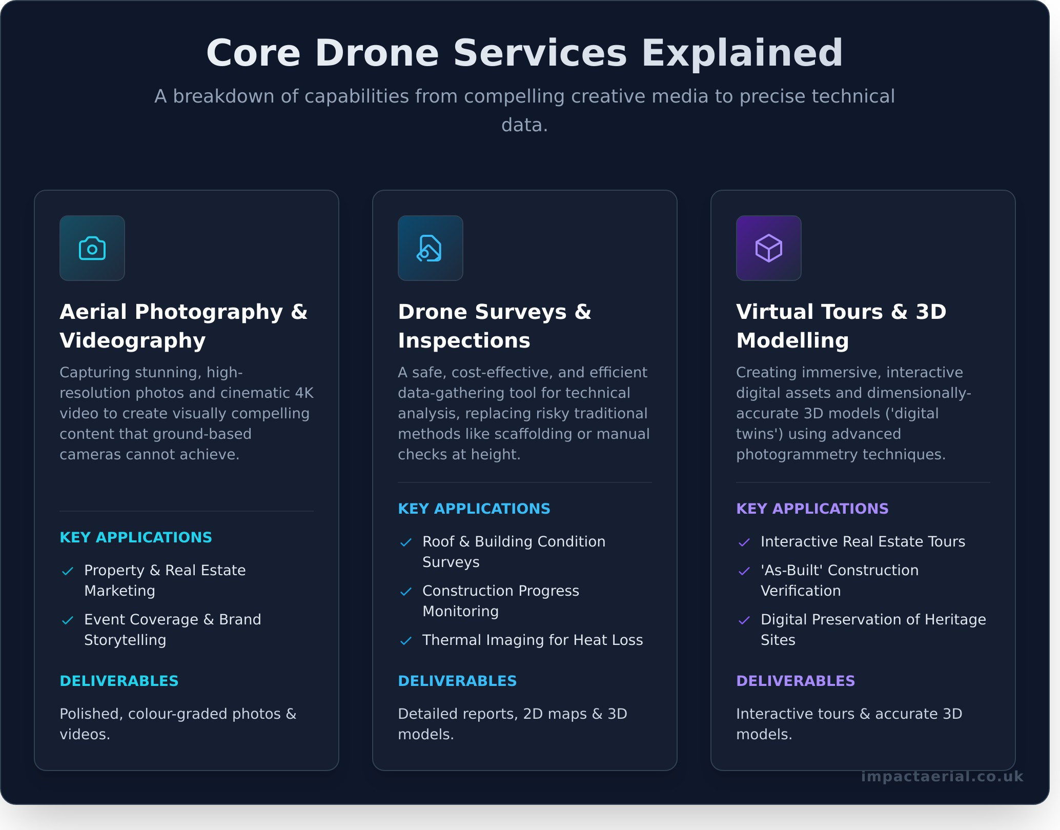
Commercial drone services can be broadly categorised into two primary functions: capturing high-quality creative media and gathering precise technical data. Understanding this distinction is the first step in identifying how a drone can deliver value for your project. Whether you need compelling marketing assets or detailed operational insights, a professional operator has the skills and technology to meet your objectives. By understanding these core capabilities, you can better select the right drone services to achieve your specific commercial goals.
Aerial Photography & Videography
This service focuses on capturing stunning, high-resolution photos and cinematic 4K video from unique aerial perspectives. It’s about creating visually compelling content that ground-based cameras simply cannot achieve. Professional operators use advanced drones with stabilised gimbals to produce smooth, professional footage ideal for property marketing, event coverage, and brand storytelling. The final deliverable is not just raw footage; it includes expert post-production and colour grading to create a polished final product ready for use.
Drone Surveys & Inspections
Here, the drone acts as a powerful data-gathering tool for technical analysis. This service provides a safe, cost-effective, and efficient alternative to traditional methods like scaffolding or manual inspections at height. Common applications include detailed roof surveys, construction progress monitoring, and thermal imaging to detect heat loss. Operating safely is paramount in these complex environments, and all professional flights must adhere strictly to the UK drone safety regulations set by the Civil Aviation Authority. The benefits are clear: reduced costs, minimised risk to personnel, and highly accurate data. Deliverables often extend beyond simple images, including detailed inspection reports, orthomosaic 2D maps, and precise 3D models.
Virtual Tours & 3D Modelling
A sophisticated extension of both creative and data services, this involves creating immersive, interactive digital assets. Using a technique called photogrammetry-stitching hundreds or thousands of high-resolution images together-we can build dimensionally accurate 3D models, or ‘digital twins’, of a property or site. These models can be used to generate interactive virtual tours for real estate marketing, monitor as-built progress in construction, or preserve heritage sites digitally. The result is a powerful tool for visualisation, planning, and engagement.
Drone Services by Industry: Real-World Applications & Benefits
The application of professional drone services extends far beyond simple aerial photography. Across the UK, industries are leveraging Unmanned Aerial Vehicles (UAVs) to gather critical data, enhance operational safety, and generate a significant return on investment. By providing a unique aerial perspective, drones solve complex logistical challenges, reduce costs, and deliver actionable insights that were previously difficult or prohibitively expensive to obtain.
Construction & Building
The construction sector has been revolutionised by the data-gathering capabilities of commercial drones. These professional services provide project managers and stakeholders with unprecedented oversight and precision, ensuring projects remain on schedule and within budget. All operations must be conducted with meticulous attention to safety and compliance, strictly adhering to the UK drone flying regulations set by the Civil Aviation Authority.
- Site Progress Monitoring: Regular, high-resolution aerial imagery and video provide a clear, chronological record of a project’s development, improving communication with clients and investors.
- Topographical Surveys: Using photogrammetry, drones can rapidly map vast sites to produce accurate topographical data and calculate earthwork volumes, saving days compared to traditional methods.
- Safety Inspections: Remotely inspect scaffolding, rooftops, and other hard-to-reach structures without putting personnel at risk, identifying potential hazards before they become critical issues.
- As-Built Records & BIM: Generate precise 3D models of completed work for Building Information Modelling (BIM), creating a detailed digital twin for asset management.
Property & Real Estate
For estate agents, property developers, and chartered surveyors, drone technology offers a powerful tool for marketing and assessment. High-quality aerial data not only attracts potential buyers but also provides essential information for valuation and maintenance planning, giving your listings a competitive edge.
- Property Marketing: Create stunning, eye-catching aerial videos and photographs that showcase a property, its grounds, and its location in relation to local amenities.
- Building Condition Surveys: Conduct detailed roof and facade inspections safely from the ground, identifying defects like damaged tiles or structural issues without the need for expensive scaffolding.
- 3D Virtual Tours: Produce immersive, interactive 3D models and virtual tours, allowing prospective clients to view a property remotely in comprehensive detail.
Marketing & Advertising
In the competitive world of marketing, unique and dynamic visuals are essential. Our drone services provide the cinematic quality and never-before-seen perspectives that make brands stand out. From sweeping landscape shots to dynamic action sequences, aerial filming captures an audience’s attention and elevates the production value of any project.
- Cinematic Footage: Capture smooth, high-resolution 4K footage for television commercials, online advertisements, and promotional films.
- Corporate Videos: Add a layer of professionalism and scale to brand stories by showcasing headquarters, facilities, or company events from the air.
- Live Event Coverage: Provide breathtaking aerial coverage of festivals, concerts, and sporting events, capturing the energy and scale of the occasion. See how our aerial filming services can elevate your brand.
How to Hire a Drone Service Provider: A 5-Step Checklist
Selecting the right partner for professional drone services is critical to ensuring your project is completed safely, legally, and to the highest standard. A reputable provider will welcome your questions and be transparent about their credentials and processes. This checklist provides a clear framework for vetting potential operators and making an informed decision.
1. Verify CAA Certification & Insurance
In the UK, any commercial drone operation must be conducted by a certified operator. For your peace of mind and legal compliance, it is essential to verify their credentials. Always ask for:
- CAA Operator ID and GVC Certificate: This proves the pilot is qualified and legally permitted to fly commercially.
- Commercial Insurance Policy: Request a copy of their current policy and confirm the public liability coverage is sufficient for your site and project requirements.
2. Review Their Portfolio and Case Studies
A provider’s past work is the best indicator of their capabilities. Look for a portfolio that demonstrates experience in your specific industry, whether it’s construction site monitoring, cinematic property tours, or agricultural surveys. Assess the quality of their aerial photography and videography, and check their website for detailed case studies or client testimonials that validate their expertise and reliability.
3. Enquire About Their Equipment
The technology used has a direct impact on the quality of your final data. Ask what specific drones and camera systems they operate, such as the DJI Enterprise series, and ensure their equipment can deliver the required output, like 4K HDR video or high-resolution thermal imagery. A professional operator will also have backup equipment on hand to prevent delays and ensure project continuity.
4. Discuss the Pre-Flight & Safety Process
A commitment to safety is the hallmark of a professional drone company. A competent pilot will always discuss their pre-flight planning, which includes conducting a thorough risk assessment, creating a detailed flight plan, and checking all airspace restrictions and weather forecasts. This meticulous approach demonstrates a commitment to safe, legal, and efficient operations. Contact us to discuss your project with our certified pilots.
5. Clarify Project Deliverables and Data Handling
Finally, ensure there is a clear understanding of the final deliverables. Discuss the exact format you will receive, whether it’s raw video footage, a fully edited promotional film, high-resolution photographs, or complex photogrammetry data. Confirm the delivery timeline and method to ensure the entire process, from flight to final output, aligns with your project goals.
Your Next Step in Professional Aerial Services
As we’ve explored, professional drone services are about far more than just flight. They represent a powerful combination of advanced technology, regulatory compliance, and versatile application, delivering everything from critical survey data to breath-taking cinematic footage. The key to unlocking this potential lies in partnering with a provider who prioritises safety, quality, and operational excellence.
At Impact Aerial, we are that trusted partner. Based in Birmingham and serving clients across the UK, our expertise in commercial property surveys and aerial filming is underpinned by our official CAA GVC Certification and full £5m commercial liability insurance, giving you complete peace of mind. We are dedicated to translating your project’s vision into high-quality, actionable results.
Ready to elevate your project from a new perspective? Discuss your project with our professional, CAA-certified team today.
Frequently Asked Questions About Drone Services
How much do professional drone services cost in the UK?
The cost of professional drone services in the UK is determined by project complexity, the equipment required, and the level of risk assessment involved. A straightforward aerial photography session may start from £250-£450 for a half-day engagement. However, more advanced applications such as detailed building inspections, 3D modelling, or cinematic video production are quoted on a project-by-project basis. This pricing reflects the pilot’s expertise, CAA certification, comprehensive insurance, and the use of high-spec commercial drones.
Can you fly drones in cities or built-up areas?
Yes, operating a drone in cities and built-up areas is possible but is a strictly regulated activity that requires a highly qualified operator. A pilot holding a GVC qualification with the correct Operational Authorisation from the Civil Aviation Authority (CAA) can conduct such flights. This process involves meticulous pre-flight planning, comprehensive risk assessments, and often coordination with local authorities or air traffic control. Safety is our paramount concern, and all operations are conducted in full compliance with regulations.
What happens if the weather is bad on the scheduled day of the flight?
Safety is our highest priority, and we will not operate our drones in unsafe weather conditions, including high winds, rain, or poor visibility. We continuously monitor forecasts in the days leading up to a scheduled flight. If the weather is deemed unsuitable, we will contact you to reschedule for the next available date at no additional cost. This ensures we can capture the highest quality data and imagery for you while adhering to strict operational safety protocols.
How long does it take to get the final photos or video after the flight?
The delivery timeframe for your final assets depends on the project’s requirements. For unedited, high-resolution still photographs, you can typically expect to receive the files within 24-48 hours. For projects that require significant post-production, such as a fully edited promotional video, colour grading, or complex data processing for photogrammetry models, the turnaround is usually between 5 and 10 working days. We will always provide a clear delivery schedule as part of our project proposal.
Do I need to get permission from neighbours to use a drone service?
While you do not personally need to seek permission, the responsibility lies with us as the professional operator to ensure the flight is conducted safely and that privacy is respected. As part of our pre-flight risk assessment, we identify any potential privacy concerns. Where appropriate, we may inform neighbours of the planned flight as a courtesy and to ensure our operation is conducted transparently. Our focus is always on the subject property, and we operate in full compliance with UK privacy laws.
What is the difference between a GVC and an A2 CofC qualification?
The A2 Certificate of Competency (A2 CofC) and the General VLOS Certificate (GVC) are two distinct CAA qualifications. The A2 CofC permits pilots to fly in lower-risk scenarios, typically further away from people. The GVC, however, is a more advanced commercial qualification required for conducting complex operations, such as flying in congested areas, that require an Operational Authorisation from the CAA. For professional drone services like ours, the GVC is the industry standard, demonstrating a higher level of competency.