Are the slow timelines, substantial costs, and inherent safety risks of traditional surveying methods impacting your project’s profitability? Manual inspections, especially when working at height, are not only dangerous but often yield inconsistent data, leading to costly delays. In today’s competitive UK market, relying on these outdated techniques is a significant liability. A professional drone survey fundamentally changes this equation, offering a modern, efficient, and far safer alternative for acquiring the high-quality data your projects demand, representing a critical evolution in professional data-gathering.
This comprehensive guide provides an authoritative overview of aerial data collection. We will explore how our CAA GVC Certified operations deliver faster, more accurate results for everything from complex roof inspections to large-scale land mapping. You will discover how leveraging advanced photogrammetry can significantly reduce project costs, eliminate on-site hazards, and provide the detailed, actionable intelligence needed to make better-informed decisions. For added peace of mind, we will explain how this technology ensures you receive the most complete and reliable data available for your next project.
What is a Drone Survey? (Beyond Just Aerial Photos)
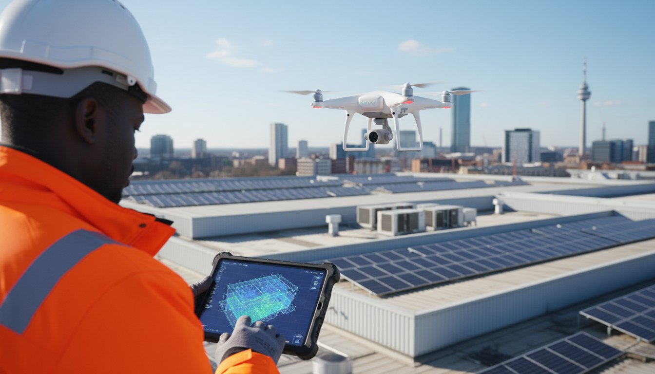
A professional drone survey moves far beyond simple aerial photography. It is a highly technical process of data gathering using advanced Unmanned Aerial Vehicles (UAVs) equipped with specialised sensors. The primary objective is not just to capture images, but to collect precise, measurable data points that can be processed into detailed topographical maps, 3D models, and analytical reports. This high-quality data provides actionable insights for industries ranging from construction and asset management to agriculture.
To better understand the fundamentals of this process, the following video provides an excellent introduction:
Traditional Surveys vs. Drone Surveys
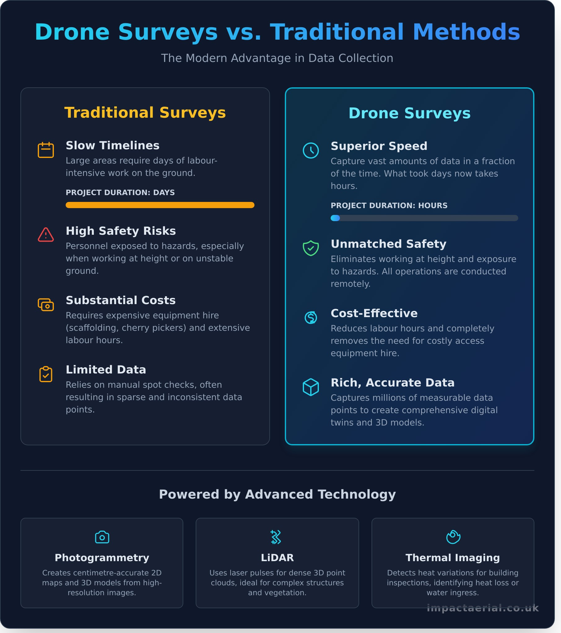
Historically, site surveys involved slow, labour-intensive, and often high-risk methods. Surveyors relied on manual measurements, expensive ground equipment, and sometimes hazardous access solutions like scaffolding or rope access. A modern drone survey, by contrast, is conducted remotely, significantly reducing on-site time, minimising disruption to operations, and completely removing the need for personnel to work at height.
- Speed: Drones capture data for large areas in a fraction of the time required for ground-based methods, often completing in hours what used to take days.
- Safety: Eliminates the risks associated with working at height or in hazardous environments. All operations are conducted from a safe distance, a critical consideration for site managers and health and safety compliance.
- Cost: Reduces the need for costly equipment hire (e.g., scaffolding, cherry pickers) and lowers labour hours, delivering significant savings and a higher return on investment.
- Data Richness: Captures millions of data points to create a comprehensive digital twin of the site, far exceeding the scope of manual spot checks and providing a more complete picture.
The Technology Behind the Data
The accuracy and versatility of a drone survey are powered by sophisticated sensor technology. Depending on the project’s requirements, a CAA GVC Certified operator will deploy one of several key data-gathering payloads:
- Photogrammetry: This is the science of making measurements from photographs. By capturing hundreds of high-resolution, overlapping images, specialised software can create highly detailed and centimetre-accurate 2D maps and 3D models. This technique forms the basis of most Unmanned aerial photogrammetric survey operations, providing rich visual and topographical data.
- LiDAR (Light Detection and Ranging): For projects demanding the highest level of accuracy, LiDAR sensors use laser pulses to measure distances and create dense 3D point clouds. This is ideal for surveying complex structures or terrain with dense vegetation.
- Thermal Imaging: Radiometric thermal cameras detect variations in heat. This is invaluable for building inspections (identifying heat loss or water ingress), solar farm assessments, and monitoring infrastructure integrity.
The Key Benefits: Why Your Project Needs a Drone Survey
Moving beyond the impressive technology, the true value of a professional drone survey lies in its tangible business advantages. For project managers, asset inspectors, and developers across the UK, drone-based data acquisition delivers a powerful return on investment by revolutionising four key areas: safety, speed, cost, and data quality. These pillars combine to produce safer working environments, accelerated project timelines, and ultimately, more profitable outcomes.
Unmatched Safety and Risk Reduction
First and foremost, drone technology fundamentally enhances on-site safety. By removing the human element from dangerous environments, you mitigate significant risks and simplify compliance with Health and Safety Executive (HSE) regulations.
- Eliminates Working at Height: Inspecting fragile roofs, church spires, or telecoms towers no longer requires scaffolding or personnel in harnesses.
- Reduces Hazard Exposure: Survey contaminated land, unstable structures, or active industrial sites from a safe distance.
- Maintains Operational Uptime: Inspect live assets like mobile phone masts or electrical substations without the need for costly and disruptive shutdowns.
Superior Speed and Efficiency
The speed of aerial data capture is transformative. A single drone flight can accomplish in hours what would take a ground team days to complete, dramatically reducing time on-site and minimising disruption to your operations. For example, a comprehensive condition survey of a 10,000 square metre commercial warehouse roof, a task that could take a team of surveyors two days using traditional methods, can be completed by a drone in under two hours.
Significant Cost-Effectiveness
The efficiency gains from a drone survey translate directly into substantial cost savings. By removing the need for expensive equipment and reducing labour hours, the financial benefits are immediate and compelling.
- Reduced Access Costs: Avoid the high expense of hiring, erecting, and insuring scaffolding, cherry pickers, or manned helicopters.
- Lower Labour Expenditure: Faster data acquisition means fewer billable hours for survey teams on-site.
- Proactive Maintenance Savings: High-resolution data can identify minor issues before they escalate into major repairs costing thousands of pounds.
High-Accuracy Data and Actionable Insights
Drones capture far more than just pictures; they produce comprehensive, measurable data sets. This high-quality information empowers stakeholders with clear, actionable insights that were previously impractical to obtain.
- Unprecedented Detail: Capture georeferenced, high-resolution imagery to generate detailed 2D orthomosaic maps.
- Powerful 3D Models: Create accurate 3D digital twins of assets, allowing for precise measurements, volume calculations, and virtual inspections.
- Seamless Integration: Data outputs are easily integrated into industry-standard software like CAD and BIM, streamlining workflows for architects and engineers.
Common Types of Drone Surveys & Industry Applications
The versatility of professional drone survey services allows for precise and efficient data-gathering across a diverse range of UK industries. By deploying specialised sensors and advanced photogrammetry techniques, drones solve critical challenges related to safety, cost, and accuracy. They transform physical assets and large-scale sites into actionable digital data, providing clarity for project managers, developers, and asset owners alike. Below are some of the most common applications.
Construction & Development
In the construction sector, a drone survey provides an unparalleled top-down view, essential for the entire project lifecycle. This technology enables safer data collection and delivers precise, repeatable results to keep projects on schedule and within budget.
- Topographic Surveys: Drones rapidly capture high-resolution elevation data to generate detailed contour maps and Digital Elevation Models (DEMs), forming a critical foundation for site planning and design.
- Progress Monitoring: Regular, automated flights create up-to-date orthomosaic maps of a site. This allows for accurate tracking of progress, and software can be used to perform precise stockpile volume calculations.
- As-Built Verification: Upon completion, a detailed 3D model of the structure can be generated and overlaid against the original BIM or CAD plans to verify accuracy and document the finished asset.
Property & Building Management
For chartered surveyors, facilities managers, and property owners, drones offer a safe and cost-effective alternative to traditional inspection methods like scaffolding or cherry pickers. They minimise risk while capturing comprehensive data on building conditions.
- Roof & Façade Inspections: High-resolution cameras identify defects such as cracked tiles, water ingress, or damaged pointing without the need for working at height, producing detailed condition reports.
- Structural Integrity Assessments: Drones capture detailed imagery of hard-to-reach areas, enabling engineers to assess the structural health of buildings, bridges, and other assets.
- 3D Virtual Tours: We can create dimensionally accurate 3D models of properties, serving as a ‘digital twin’ for marketing, insurance documentation, or facilities management.
By providing clear, objective data, our services help you make informed decisions about maintenance and asset value. See how our Drone Property Surveys can benefit you.
Energy & Utilities
The vast scale of energy and utility infrastructure makes it an ideal candidate for drone deployment. Drones can cover large areas quickly and safely inspect assets that are often remote or dangerous to access manually.
- Solar & Wind Farm Inspections: Thermal cameras identify faulty panels on solar farms that are underperforming. Drones also capture high-resolution images of wind turbine blades to detect cracks and erosion.
- Infrastructure & Power Line Mapping: Drones can efficiently survey long corridors of infrastructure like power lines or pipelines, identifying vegetation encroachment and asset condition issues before they become major problems.
How to Choose a Professional Drone Survey Provider in the UK
Selecting the right partner for your aerial data-gathering project is a critical business decision. A professional drone survey involves far more than simply flying a drone; it demands meticulous planning, strict regulatory compliance, and deep technical expertise. To ensure a safe, legal, and successful outcome for your project, use this checklist to vet any potential provider.
Essential: CAA Certification and Permissions
In the UK, all commercial drone operations are regulated by the Civil Aviation Authority (CAA). Any legitimate provider must hold a current Operational Authorisation from the CAA, which requires their pilots to possess qualifications like the General Visual Line of Sight Certificate (GVC). Hiring an uncertified operator is illegal and exposes your project, site, and company to significant liability and risk. Always insist on seeing proof of their CAA permissions.
Crucial: Commercial Insurance
Standard business insurance policies do not cover commercial drone flights. A professional operator is required by law to hold specialist commercial drone liability insurance compliant with regulation EC785/2004. For added peace of mind, look for a provider with cover of at least £5 million. This is non-negotiable and protects your assets, site, and personnel in the unlikely event of an incident.
Expertise: Experience and Equipment
Not all drone services are equal. Review a provider’s portfolio to ensure they have proven experience with projects similar to yours. A provider specialising in a complex topographical drone survey will have different skills and equipment than one focused on marketing videography. Enquire about the drones they use-such as DJI Enterprise grade models-and confirm they can deliver the specific data outputs you need, from photogrammetry point clouds to high-resolution thermal imagery.
Process: Clear Communication and Deliverables
A hallmark of professionalism is a clear and transparent project workflow. Your chosen provider should supply a detailed quote, a comprehensive statement of work, and conduct a thorough risk assessment before any flight. It is vital to confirm the exact data formats you will receive (e.g., .LAS, .OBJ, high-res JPEGs) and the expected delivery timeline to ensure the final product aligns perfectly with your needs.
Ultimately, a reputable provider will be transparent and proud of their credentials, understanding that trust is built on a foundation of safety, compliance, and proven results. We invite you to verify our credentials and expertise to see how we meet and exceed these professional standards for every project.
Transform Your Project Data with a Professional Drone Survey
As this guide has shown, the modern drone survey is a transformative tool, moving far beyond simple aerial photography to deliver precise, actionable data. For projects across the UK, from construction sites to property inspections, the benefits are clear: enhanced safety, significant cost savings, and unparalleled efficiency. The crucial step is choosing a provider with the technical expertise and regulatory compliance to execute the mission flawlessly.
At Impact Aerial, we provide the professional services your project demands. Our operations are conducted by CAA GVC Certified Pilots who are specialists in using leading DJI Enterprise drones for high-quality data-gathering. For your complete peace of mind, every flight is backed by £5m in commercial liability insurance, ensuring a service that is not only effective but also meticulously compliant and safe.
Ready to see your project from a new, data-rich perspective? Take the next step towards superior insights and operational excellence.
Discuss your project with our certified survey experts.
Frequently Asked Questions About Drone Surveying
How accurate are drone surveys?
Modern professional drones equipped with Real-Time Kinematic (RTK) or Post-Processed Kinematic (PPK) GPS technology can achieve exceptional survey-grade accuracy. When combined with strategically placed Ground Control Points (GCPs), we can deliver data with an absolute accuracy of typically 1-3 centimetres. This level of precision is often superior to traditional surveying methods, providing highly reliable and detailed topographical data, digital terrain models, and 3D point clouds for your project’s specific requirements.
How much does a professional drone survey cost in the UK?
The cost of a professional drone survey in the UK varies based on several key factors, including the size and complexity of the site, the required data resolution, and the level of post-processing needed. A small, straightforward site survey may start from around £450-£600. For larger projects requiring detailed 3D models or volumetric calculations, costs will be higher. We provide a detailed, itemised quotation after a thorough consultation to ensure complete transparency and value.
Are drone surveys legal and what are the main regulations?
Yes, professional drone surveys are entirely legal in the UK when conducted by a qualified and certified operator. All commercial operations must adhere to strict Civil Aviation Authority (CAA) regulations. This means the operator must hold a General Visual Line of Sight Certificate (GVC) and have an Operational Authorisation from the CAA. For added peace of mind, we are fully insured and operate strictly within these legal frameworks, ensuring every flight is both safe and compliant.
What kind of data and file formats will I receive after a survey?
The deliverables from your survey are tailored to your project’s needs and are compatible with industry-standard software like AutoCAD and GIS platforms. Common outputs include high-resolution orthomosaic maps (GeoTIFF), detailed 3D point clouds (.LAS, .LAZ), Digital Surface Models (DSM), and textured 3D meshes (.OBJ). We also provide high-definition imagery and video where required. We will consult with you beforehand to ensure the final data-gathering process delivers the exact file formats you need.
How long does a typical drone survey take from start to finish?
The timeline for a complete drone survey project involves three main phases. The initial planning and risk assessment phase can take a few days. The on-site data capture is highly efficient, often taking just a few hours for a standard-sized site. The final and most intensive stage is data processing, which can range from 2 to 5 working days depending on the complexity of the required outputs. We always provide a clear project timeline in our proposal.
Can drones fly in bad weather like rain or high winds?
For safety and data quality reasons, we cannot operate our drones in rain or fog, as moisture can damage sensitive electronics and obscure sensor data. Our commercial drones can handle moderate wind speeds, typically up to around 22 mph, but we constantly monitor conditions on-site. If the weather is deemed unsafe or unsuitable for high-quality data capture, we will always prioritise safety and reschedule the flight for the next available opportunity at no extra cost.