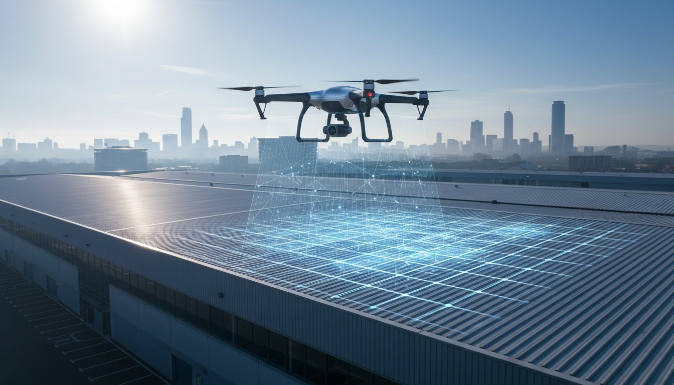
Did you know that utilizing high-resolution aerial data can improve underwriting accuracy by 40 to 60 percent, effectively turning a drone survey for commercial insurance renewal into your strongest negotiation tool? As commercial premiums rise toward a projected 1.73 billion dollar market in 2026, many owners find it difficult to prove proactive maintenance through traditional, dangerous, and costly manual inspections. It’s frustrating to face higher rates simply because you lack the “clean” data report that modern brokers now demand for a favorable risk assessment.
Securing a professional aerial inspection provides the irrefutable evidence needed to de-risk your portfolio and can lead to a 55 percent reduction in inspection costs compared to legacy methods. This guide outlines how to leverage the latest FAA Part 108 regulations and updated ALTA/NSPS standards to streamline your renewal process. You’ll learn exactly which data points satisfy underwriters and how our meticulously maintained fleet delivers zero-disruption results for total peace of mind.
Key Takeaways
- Understand why 2026 underwriters are moving away from “assumed risk” and how high-resolution evidence can directly reduce uncertainty loading on your premiums.
- Learn how a professional drone survey for commercial insurance renewal identifies hidden defects like moisture ingress using advanced 4K HDR and thermal imaging technology.
- Compare the ROI of aerial inspections against traditional methods, focusing on the elimination of “working at height” risks and significantly faster data turnaround.
- Follow a streamlined preparation checklist to identify site-specific risks and manage tenant notifications for a smooth, zero-disruption inspection.
- Discover why CAA GVC Certification and professional credentials are required to ensure your survey data is accepted as irrefutable evidence by major insurers.
Why Insurers Demand Drone Surveys for Commercial Renewals in 2026
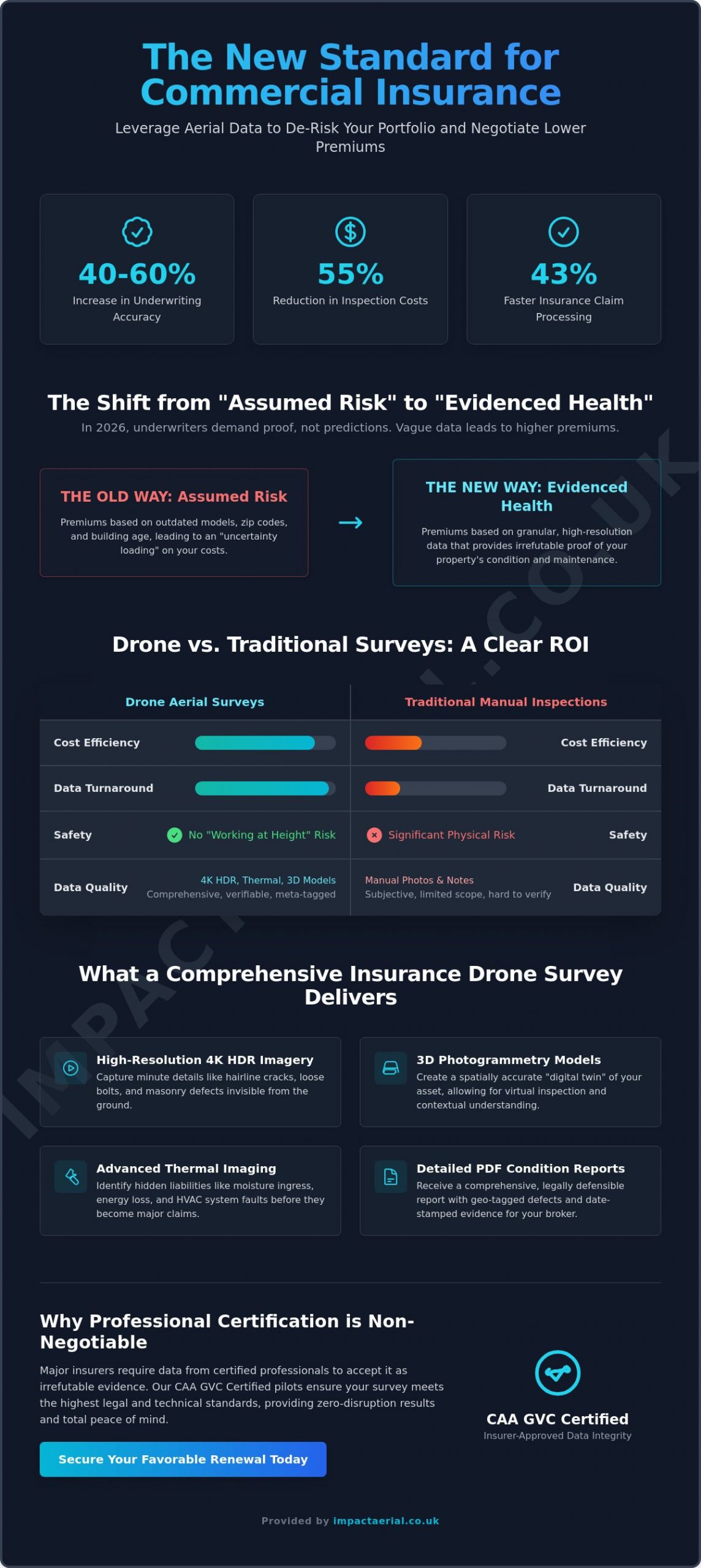
The insurance landscape in 2026 has moved decisively toward data-driven transparency. Underwriters no longer rely on broad “assumed risk” models based on zip codes or building age alone. Instead, they demand “evidenced health.” By commissioning a drone survey for commercial insurance renewal, property managers provide granular proof of a building’s structural integrity. This shift reduces “uncertainty loading,” which is essentially a premium buffer that insurers apply when they lack clear data on a property’s condition. With the drone insurance market projected to reach 1.73 billion dollars this year, the financial incentive for transparency has never been higher.
The deployment of a sophisticated unmanned aerial vehicle (UAV) allows for the identification of liabilities that ground-based inspections simply miss. Issues like standing water on flat roofs, blocked guttering, or thermal leaks in HVAC systems are captured in high resolution. This prevents small maintenance gaps from becoming catastrophic claims that inflate your loss ratio. Insurers now prioritize UAV data because it offers 40 to 60 percent better underwriting accuracy than traditional methods. It provides a level of detail that ground-level assumptions cannot match, especially for high-value industrial assets.
To better understand how these aerial assessments integrate with the insurance industry, watch this helpful video:
From Reactive to Proactive Risk Management
Moving from reactive repairs to proactive management is essential for maintaining low premiums in a tightening market. Professional aerial surveys create a chronological record of an asset’s condition. This historical data is vital during claim disputes; it allows you to distinguish between long-term wear and tear and sudden storm damage with 100 percent certainty. When you update your “Statement of Fact” document for a broker, including a certified survey report demonstrates a level of meticulousness that underwriters reward with better terms. Data shows that using drones can lead to 43 percent faster processing of insurance claims for damage assessments, getting your business back to full operation sooner.
Meeting the Requirements of Major UK Brokers
Major UK brokers have moved beyond accepting simple smartphone photos or hobbyist snapshots. They require high-resolution 4K HDR imagery that includes embedded metadata and precise date-stamping. This technical rigor ensures the data is tamper-proof and legally defensible. A generic aerial photo doesn’t provide the zoom capabilities needed to inspect a single loose bolt on a 50-foot cladding panel or a hairline crack in a chimney stack. A professional drone survey acts as a high-fidelity digital twin of your commercial asset, providing a comprehensive and interactive record that de-risks the entire insurance lifecycle. By providing this “clean” survey report, you eliminate the guesswork that often leads to inflated premium quotes.
What a Comprehensive Insurance Drone Survey Includes
A comprehensive drone survey for commercial insurance renewal is a multi-layered data asset rather than a simple collection of aerial photographs. To satisfy the rigorous requirements of 2026 underwriters, a survey must provide a holistic view of the property. This includes high-resolution 4K High Dynamic Range (HDR) imagery that captures minute details of roof coverings, masonry, and facade elements. The Insurance Information Institute highlights how this level of transparency improves the risk assessment process by providing a clear, verifiable baseline of property health. We supplement this visual data with 3D photogrammetry to create a spatially accurate digital twin of the entire site. This allows stakeholders to understand the property’s context and condition without the need for physical site visits.
The final deliverable is a detailed PDF condition report. Unlike a standard photo gallery, these reports feature geo-tagged high-priority defects, allowing maintenance teams to locate and repair issues with surgical precision. Every survey we conduct adheres to the updated ALTA/NSPS standards finalized on February 23, 2026, which formally recognize drone data in land title and property assessments. This compliance ensures that the data you provide to your broker is legally robust and professionally vetted. For added peace of mind, our operations are backed by a minimum of 1 million pounds in commercial liability insurance, meeting the de facto standard for professional drone services.
Thermal Surveys for Solar and Flat Roofs
Identifying moisture ingress is a primary concern for flat roof owners, as trapped water can lead to structural failure long before a leak becomes visible inside. Thermal imaging detects temperature variances that indicate insulation failure or water saturation. This technology is indispensable for assets with integrated renewable energy. Our PV Solar Farm Thermal Surveys identify cell failures and electrical “hot spots” that represent significant fire risks. By catching these anomalies early, you protect your investment and prove to your insurer that you are managing fire risks proactively.
Visual Facade and Cladding Inspections
Traditional cladding inspections often require expensive scaffolding or cherry pickers, adding layers of cost and health and safety paperwork. Drones eliminate these overheads while capturing high-detail images of guttering, flashings, and parapet walls from angles that are impossible to reach from the ground. This level of detail is essential for maintaining fire safety documentation for high-rise commercial units. If you’re looking to streamline your next property assessment, you can view our full range of professional aerial services to see how we capture these critical data points.
Drone vs. Traditional Surveys: A Comparison of ROI
When you evaluate a drone survey for commercial insurance renewal, the return on investment extends far beyond the initial service fee. Traditional methods often require hiring cherry pickers or erecting scaffolding, which can inflate costs and create significant liability. Utilizing drones for infrastructure inspections results in a 55 percent cost reduction compared to these legacy methods. Safety is the most immediate gain. By eliminating the “Working at Height” risk, you remove a major hazard from your site’s risk profile. This is a key factor that underwriters consider when reviewing your own business insurance requirements.
The speed of delivery is equally transformative for large-scale assets. While a traditional survey crew might spend several days inspecting a 50,000 sq ft warehouse, a professional drone team completes the data-gathering process in just a few hours. This rapid turnaround allows you to submit your renewal documentation weeks ahead of the deadline, giving your broker more time to negotiate favorable terms. For added peace of mind, our operations are conducted by meticulous pilots who adhere to the same rigorous safety standards found in FAA regulations for commercial operators, ensuring every flight is compliant and low-risk.
Eliminating Access Costs and Site Disruption
Drones are the preferred method for “business-as-usual” inspections because they don’t require site shutdowns. You don’t have to cordon off parking lots or manage the logistics of heavy machinery in public-facing commercial areas. This lack of disruption is vital for retail parks or active logistics hubs where every hour of downtime has a price tag. Aerial technology also reaches “un-surveyable” areas like steep roof valleys and internal light wells. These locations are often ignored during ground-level binocular checks but are frequently the source of hidden structural liabilities.
The Quality Gap: Data You Can Zoom Into
The depth of data provided by aerial technology creates a significant quality gap. A standard handheld camera or a pair of binoculars can’t match the 20MP resolution of a professional DJI Enterprise drone. These high-resolution files allow you to zoom in on individual fasteners or hairline cracks with absolute clarity. We also produce “orthomosaic” maps, which are massive, high-resolution files showing the entire site in a single, measurable image. To understand the technology behind these results, read our guide on what is a survey drone. This level of detail provides the irrefutable evidence that underwriters need to approve your renewal with confidence.
Preparation Checklist: Getting Your Site Ready for Survey
A successful drone survey for commercial insurance renewal requires more than just booking a flight date. To maximize the value of the data-gathering process, property managers must follow a structured preparation phase. This ensures that the pilot captures every critical detail required by your underwriter without the need for costly re-flights or data gaps. Proper preparation also facilitates the 40 to 60 percent improvement in underwriting accuracy that professional aerial data provides.
- Step 1: Identify key risk areas. Highlight known issues such as historical leaks, aging cladding, or complex PV solar arrays. This allows the pilot to prioritize these zones for high-detail 4K capture during the flight.
- Step 2: Notify tenants and stakeholders. While 67 percent of construction and property firms now use drones, early communication remains essential. Informing occupants of the flight date ensures privacy compliance and prevents operational friction on the day.
- Step 3: Ensure clear access to the site perimeter. Pilots require a safe takeoff and landing area (TOLA). Clearing a small section of the perimeter or ensuring flat roof access allows for efficient, zero-disruption operations.
- Step 4: Collate previous years’ records. Comparative analysis is a powerful tool in risk management. Having 2024 or 2025 aerial data ready allows you to prove that your maintenance schedule is consistent and proactive.
Briefing Your Drone Pilot
Your pilot needs a clear technical brief to deliver the results your broker expects. Provide detailed site maps and explicitly highlight any areas requested by your insurer, such as parapet walls or internal light wells. Discussing data formats is also vital. While JPEGs are standard for reports, your internal engineering team might require RAW files or specific photogrammetry outputs for long-term asset management. Most importantly, verify that the pilot has prepared site-specific Risk Assessments and Method Statements (RAMS). A professional operator will always provide these documents to ensure the flight is conducted within the latest safety parameters for added peace of mind.
Presenting Data to Your Broker
Once the survey is complete, the report becomes your primary negotiation asset. Use the high-resolution imagery to highlight “repaired” defects. This provides irrefutable proof that you’ve addressed previous concerns, which can help lower premiums by reducing the “uncertainty loading” applied by underwriters. 3D models are particularly effective for complex commercial claims, providing brokers with a 360-degree view of the property’s condition. If you are ready to begin this process, you can book your professional property survey here to secure the data you need for a successful renewal.
Why Professional Certification is Non-Negotiable for Insurers
Insurers are increasingly meticulous about the source of the data they use for risk assessment. A drone survey for commercial insurance renewal is only as valid as the certification of the pilot who conducted it. Utilizing “hobbyist” data is a significant risk for any property manager. If a flight doesn’t comply with UK law, an insurer can reject the findings entirely, leaving you with a useless report and a potentially higher premium. Compliance isn’t a suggestion; it’s a fundamental requirement for the data to be legally defensible during a renewal or a claim.
Our fleet features the latest DJI Enterprise technology, which allows for consistent and repeatable data sets. Unlike consumer-grade drones, these systems provide precise flight path telemetry. This means we can recreate the exact same inspection year after year, providing underwriters with a longitudinal view of your asset’s health. To support these high-tech operations, we maintain £5 million in commercial liability insurance. While many operators stick to the de facto £1 million minimum, our higher level of coverage provides the robust safety net required by high-value industrial and retail assets.
The Role of CAA GVC Certified Pilots
The legal framework for commercial drone operations in the UK is governed by the Civil Aviation Authority (CAA). To operate legally in a commercial capacity, pilots must hold a GVC (General Visual Line of Sight Certificate). This certification acts as a marker of safety and professional standards, proving the pilot understands complex airspace regulations and risk mitigation. If you’re unsure about the current rules, our UK Drone License Guide explains the latest 2026 requirements in detail. Choosing a certified professional ensures your data is gathered safely and is fully compliant with the latest aviation laws.
Impact Aerial: Your Partner in Commercial Renewals
Based in Birmingham and the West Midlands, we serve the UK property sector with a commitment to technical precision. Our team manages the entire lifecycle of your survey, from the initial site consultation to the final post-production of your condition report. We don’t just deliver photos; we provide a verified data asset that strengthens your position with your broker. Our meticulous, vetted, and professional team provides total peace of mind by ensuring every flight is legal, insured, and technically superior. This structured approach allows you to focus on your business while we handle the complexities of aerial data gathering.
Take Control of Your 2026 Insurance Renewal
The transition from “assumed risk” to “evidenced health” is now the standard for the UK property sector. By providing your broker with a professional drone survey for commercial insurance renewal, you eliminate the uncertainty that often leads to inflated premiums. You’ve seen how high-resolution data improves underwriting accuracy by up to 60 percent while reducing physical inspection costs by 55 percent. It’s a strategic move that protects both your physical assets and your bottom line.
Impact Aerial provides the technical expertise and regulatory compliance required for high-stakes renewals. Our team uses the latest DJI Enterprise 4K HDR technology and operates with 5 million pounds in commercial liability insurance for added peace of mind. As specialists serving the West Midlands and clients nationwide, we ensure your property data is irrefutable and professionally vetted by CAA GVC Certified pilots. Don’t leave your next renewal to chance. Secure your commercial renewal with a professional drone survey from Impact Aerial and enter your next negotiation with total confidence.
Frequently Asked Questions
Will my insurance company accept a drone survey for my renewal?
Yes, insurers increasingly mandate these surveys because they provide irrefutable evidence of property condition. As of February 23, 2026, the updated ALTA/NSPS standards formally recognize drone data in property assessments. Providing a drone survey for commercial insurance renewal helps you move from “assumed risk” to “evidenced health,” which underwriters prefer. It ensures your data is legally robust and satisfies the rigorous transparency requirements of 2026 insurance markets.
How much does a commercial drone survey cost in 2026?
Costs vary based on the technology used and the site’s scale. According to 2026 industry reports, a standard commercial roof inspection typically ranges from $400 to $1,200. More complex photogrammetry surveys can cost between $1,500 and $10,000, while LiDAR surveys for large industrial estates range from $3,000 to $15,000. These figures reflect the specialized equipment and data analysis required for professional-grade insurance documentation that underwriters can trust.
Do I need to shut down my business during the drone survey?
No, business-as-usual operations continue without interruption during our aerial inspections. Drones eliminate the need for scaffolding, cherry pickers, or cordoned-off parking areas that traditional methods require. Since the pilot operates from a safe takeoff area, your staff and tenants won’t be impacted. This zero-disruption approach is why 67 percent of construction and property firms now prefer aerial methods over traditional ground-based inspections that require site shutdowns.
What happens if the drone survey finds a major defect during renewal?
Finding a defect early is a strategic advantage for your renewal process. It allows you to address the issue and provide proof of repair before the final policy is bound. By showing proactive maintenance, you reduce the “uncertainty loading” that insurers apply to unknown risks. Utilizing a drone survey for commercial insurance renewal can enhance underwriting accuracy by 40 to 60 percent, often leading to more favorable terms.
Is a drone survey better than a traditional roof survey for insurance?
Yes, drones offer superior safety and data depth compared to manual inspections. Utilizing aerial technology results in a 55 percent cost reduction and eliminates the “Working at Height” liability for your business. You receive high-resolution 4K HDR imagery that captures defects invisible to ground-level binocular checks. Additionally, drones enable 43 percent faster claims processing if damage occurs, ensuring your asset is back to full operation as quickly as possible.
What certifications should I look for when hiring a drone surveyor?
You must ensure the pilot holds a valid CAA GVC Certification in the UK or a Part 107 Remote Pilot Certificate in the US. These certifications guarantee the operator has the aeronautical knowledge required for safe, legal flights. You should also verify they carry at least £1 million in commercial liability insurance. Professional operators will always provide their registration and insurance documents for your added peace of mind before starting any work.
Can drones perform thermal surveys for commercial insurance?
Yes, thermal imaging is a critical component of a comprehensive insurance survey. It identifies moisture ingress in flat roofs and “hot spots” in PV solar arrays that indicate electrical fire risks. By detecting temperature variances, thermal drones find hidden water intrusion that could lead to structural failure. This data is essential for 2026 renewals, as it provides proof of healthy insulation and functioning, safe renewable energy systems.
How long does it take to receive the final insurance survey report?
Most professional reports are delivered within 48 to 72 hours of the flight. This rapid turnaround includes the processing of high-resolution imagery and the creation of a detailed PDF condition report. Every defect is geo-tagged and timestamped to provide a legally defensible record for your broker. This speed allows you to submit your renewal documentation well ahead of deadlines, facilitating a smoother and more efficient negotiation process with your provider.
