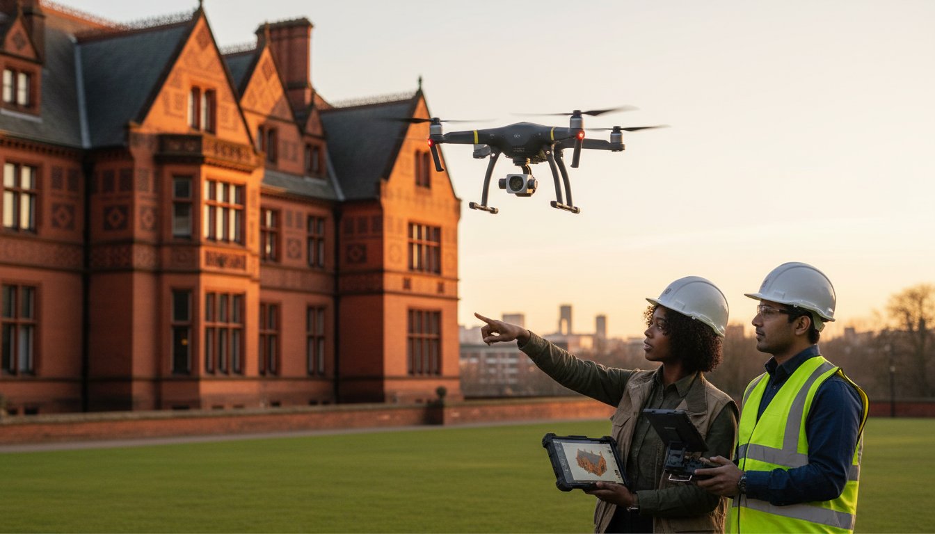
Traditional scaffolding for a routine chimney inspection on a Grade II listed manor often exceeds £3,500 before a surveyor even sets foot on the roof. For the guardians of the UK’s 378,000 listed entries, this financial burden is only matched by the physical risk that heavy access equipment poses to fragile, historic masonry. Utilizing professional drone photography for listed buildings has become the modern standard for mitigating these risks while maintaining the highest levels of structural oversight.
You likely understand the stress of managing these historic assets while navigating strict heritage regulations and tightening conservation budgets. This guide reveals how aerial surveying provides a safer, more precise alternative that delivers the millimetre-accurate data required for National Lottery Heritage Fund applications. We’ll examine the technical requirements for CAA GVC certified operations near heritage sites and show you how to capture high-resolution imagery of inaccessible parapets and leadwork for your conservation records with total peace of mind.
Key Takeaways
- Understand how UAV technology has evolved from simple filming into an essential, data-driven conservation tool for protecting the UK’s historic assets.
- Learn why professional drone photography for listed buildings is a legal necessity to mitigate the significant insurance and regulatory risks associated with uncertified hobbyist pilots.
- Discover how to significantly reduce maintenance overheads by replacing costly “access only” scaffolding with rapid, high-resolution aerial surveys that deliver insights in hours rather than weeks.
- Master the practicalities of heritage site assessments, from identifying environmental hazards to liaising effectively with local conservation officers and planning authorities.
- Explore how utilising Impact Aerial’s advanced drone fleet allows for the simultaneous capture of cinematic promotional media and precision technical data for comprehensive structural analysis.
Table of Contents
- What is Drone Photography for Listed Buildings?
- Navigating UK Drone Laws and Heritage Regulations
- ROI: Comparing Drones to Traditional Scaffolding
- Planning a Heritage Drone Shoot: A Practical Checklist
- Impact Aerial: Specialist Drone Services for UK Heritage
What is Drone Photography for Listed Buildings?
Drone photography for listed buildings involves the deployment of Unmanned Aerial Vehicles (UAVs) to capture high-resolution imagery and precise technical data of protected heritage structures. This process isn’t merely about taking “aerial photos”; it’s a sophisticated data-gathering exercise. We use 4K High Dynamic Range (HDR) DJI Enterprise commercial drones to document every centimetre of a structure, from its weather-worn chimney stacks to its intricate stonework. This specialised field bridges the gap between creative media and structural engineering, providing a level of detail that was historically impossible to achieve without significant capital expenditure.
This technology has undergone a massive shift in the UK over the last decade. Back in 2014, aerial filming was often viewed as a novelty or a luxury reserved for high-budget cinema. Since the 2016 update to Civil Aviation Authority (CAA) regulations and the subsequent introduction of the GVC (General Visual Line of Sight Certificate), drones have become an essential conservation tool. For the 400,000 plus structures on the National Heritage List for England, these UAVs provide a safe, repeatable, and highly accurate way to monitor the “health” of our nation’s history.
A Listed Building is categorised by its significance, with Grade I, Grade II*, or Grade II status dictating the level of protection. Modern warehouses or office blocks are built with standard materials and accessible designs, but heritage assets are often fragile and geographically complex. They require a specialised approach because the stakes are higher. One wrong move with a ladder can cause irreparable damage to 16th-century timber or 18th-century masonry. When commissioning drone photography for listed buildings, it’s vital to work with operators who understand these risks and hold the necessary commercial liability insurance.
The role of the drone is dual-purpose. It serves a marketing and storytelling function, creating breath-taking visuals that help heritage sites attract visitors or secure funding. Simultaneously, it serves a technical function, acting as the “eyes” for conservation officers and architects. This allows for a proactive maintenance programme rather than a reactive, and often more expensive, repair schedule.
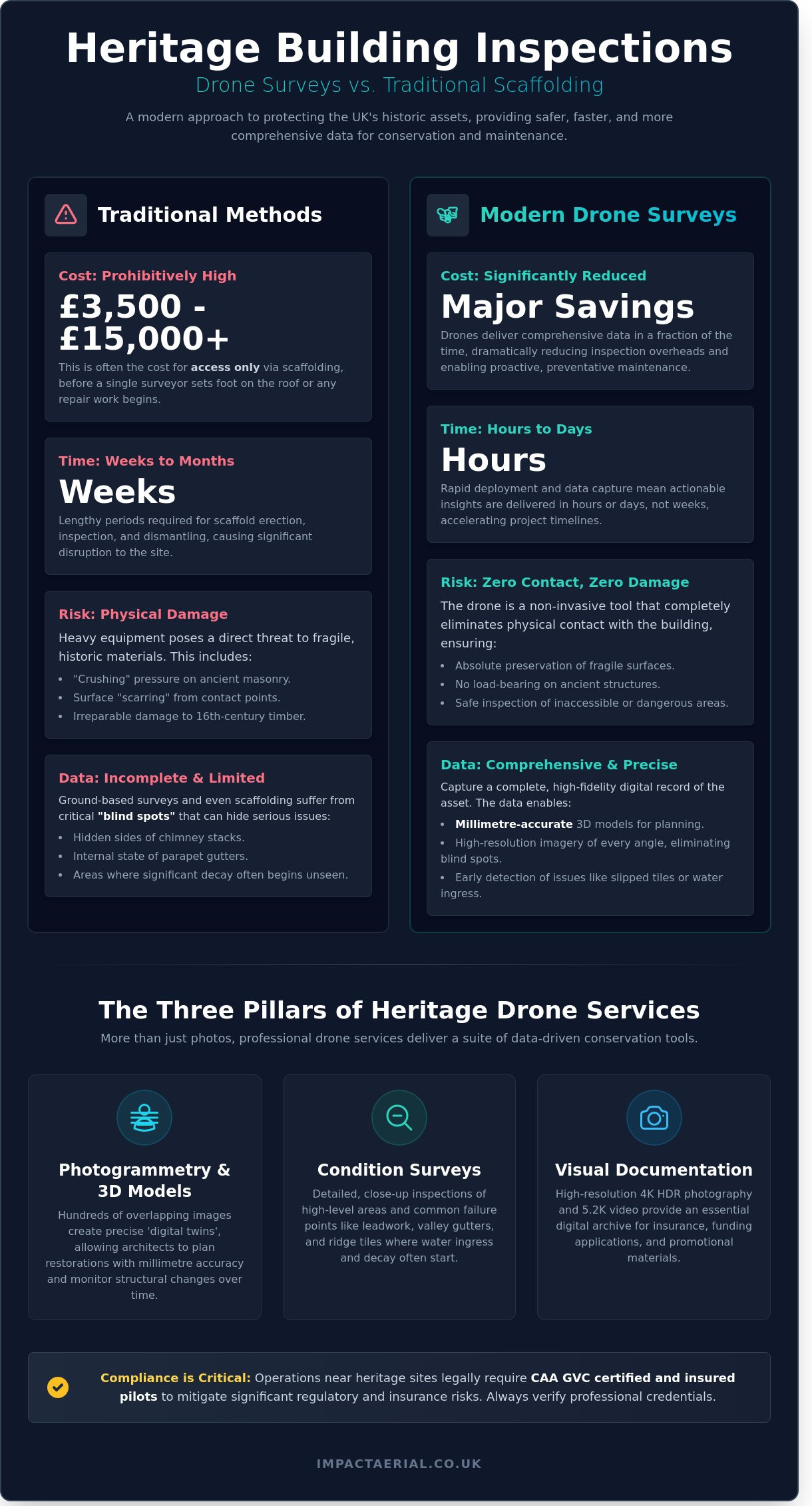
The Three Pillars of Heritage Drone Services
- Visual Documentation: We produce high-resolution 4K HDR photography and 5.2K video content. These assets are vital for digital archives, providing a historical record that can be used for promotion or to prove the building’s condition for insurance purposes.
- Condition Surveys: Our drones perform detailed close-up inspections of high-level areas. We focus on common failure points like leadwork, valley gutters, and ridge tiles, where water ingress often starts.
- Photogrammetry: This involves taking hundreds of overlapping images to create 3D digital twins. These models allow architects to plan restorations with millimetre precision and monitor structural movement over time.
Why Traditional Methods Fall Short
Traditional access methods like ladders, cherry pickers, or full-scale scaffolding carry inherent physical risks. Scaffolding a medium-sized church can easily cost between £5,000 and £15,000 before a single repair even begins. Beyond the cost, the sheer weight and pressure of these structures against fragile stone or timber can lead to “crushing” or surface scarring. Drones eliminate this contact entirely, removing the risk of accidental damage during the inspection phase.
Ground-based photography also suffers from “blind spots” that can hide serious conservation issues. A surveyor standing in a courtyard cannot see the internal state of a parapet gutter or the hidden side of a chimney stack. These hidden areas are often where the most significant decay occurs. Drone technology provides a completely non-invasive method of data collection that eliminates physical contact with sensitive heritage materials. By identifying a slipped tile or a blocked hopper early, we help clients avoid the catastrophic costs of internal rot or structural failure.
Navigating UK Drone Laws and Heritage Regulations
Operating a drone near a Grade I or Grade II* structure isn’t just about pilot skill; it’s about strict legal compliance. The Civil Aviation Authority (CAA) governs all UK airspace, and their regulations become significantly more complex when dealing with historic assets. Property owners often underestimate the legal weight of The Drone and Model Aircraft Code, which dictates how and where unmanned aircraft can fly. Failing to adhere to these rules can result in unlimited fines or even imprisonment for both the pilot and the person who commissioned the work.
Hiring a “hobbyist” pilot for drone photography for listed buildings is a gamble that rarely pays off. Most recreational drone insurance policies explicitly exclude commercial work and won’t cover damage to historic fabric. If a drone strikes a 16th-century chimney stack, a hobbyist policy will likely be void. This leaves the property owner liable for restoration costs that can easily exceed £50,000. Professional operators understand that heritage sites often sit within restricted zones or require specific permissions from bodies like Historic England and English Heritage. These organisations frequently maintain their own byelaws regarding take-off and landing on their land, which must be negotiated weeks in advance.
The Importance of CAA GVC Certification
The General Visual Line of Sight Certificate (GVC) is the current gold standard for professional drone operations. It replaced the old PfCO (Permission for Commercial Operations) following the regulatory transition that began on 31st December 2020. By 2026, the GVC will be the primary requirement for pilots flying in the “Specific Category,” which is where most heritage work occurs. This qualification proves a pilot can safely manage a flight in congested or sensitive areas. Our pilots use professional flight planning software to identify heritage-specific restrictions, site-specific hazards, and local weather patterns. This data-driven approach ensures every flight is legal, safe, and efficient.
Insurance and Liability for Historic Assets
Standard drone insurance is insufficient for a Grade I listed manor or a complex industrial heritage site. We maintain £5 million in commercial liability insurance as a minimum standard. This level of cover provides essential peace of mind when operating multi-rotor aircraft near fragile masonry or lead roofing. You should always verify a pilot’s insurance and certification through a vetted body. You can find qualified aerial specialists who carry the correct level of cover for high-value assets. This verification protects you from the catastrophic financial risks associated with unlicensed or under-insured operators.
- Verify the GVC: Ensure the pilot’s CAA Flyer ID and Operator ID are current and valid for 2026 standards.
- Check Liability: Confirm the insurance policy specifically covers commercial aerial work and not just general public liability.
- Site Permissions: Confirm if the site is a Scheduled Monument, as this may require additional consent from the Department for Culture, Media and Sport.
Professional drone photography for listed buildings requires a meticulous approach to risk management. It’s not just about capturing the perfect shot; it’s about protecting the integrity of the UK’s most precious architectural landmarks through rigorous adherence to CAA protocol.
ROI: Comparing Drones to Traditional Scaffolding
Traditional methods for inspecting Grade I or Grade II listed structures often rely on “access only” scaffolding. For a standard chimney or roof valley inspection, scaffolding costs frequently range between £2,500 and £6,000 before a single repair even begins. These figures represent sunk costs that provide no permanent value to the building. By contrast, professional drone photography for listed buildings delivers a comprehensive visual assessment for a fraction of that investment, with typical daily rates for a CAA GVC certified pilot falling between £600 and £1,200. This shift in expenditure allows estate budgets to be redirected from temporary metal poles toward actual conservation work.
The time-to-insight is equally transformative. Erecting a scaffold tower requires a 10-day lead time for planning, permit acquisition, and assembly. A drone survey team can arrive, conduct a pre-flight safety briefing, and capture every angle of a roofline in under 3 hours. This speed allows for rapid decision-making. According to 2023 Health and Safety Executive (HSE) data, falls from height remain the leading cause of workplace fatalities in the UK, accounting for 33% of all fatal accidents. Using drones removes the necessity for personnel to traverse unstable parapets or ancient leadwork, significantly lowering the risk profile of any maintenance project.
Preventative maintenance offers the highest return on investment. A single loose slate identified via 4K aerial imagery might cost £200 to fix using a cherry picker. If left undetected, that same slate leads to water ingress that can cause £15,000 of damage to historic lime plasterwork or structural timber frames within 12 months. Drones find these “needle in a haystack” issues before they become catastrophic financial burdens.
Cost-Benefit Analysis for Estate Managers
Direct costs are only one part of the equation. Estate managers must also account for indirect savings. Closing a heritage site to visitors for three days to allow for scaffold installation can result in a loss of £4,500 in ticket and gift shop revenue. Drones operate without requiring site closures or unsightly hoarding that ruins the visitor experience. Additionally, high-quality aerial data is a powerful tool for grant applications. Historic England and the National Lottery Heritage Fund often require detailed condition reports; providing 4K visual evidence can accelerate the approval process for funding by 25% compared to written reports alone.
The Value of Digital Records in Conservation
Deploying drone photography for listed buildings creates a permanent digital twin of the structure. Using 4K imagery allows conservationists to track the rate of decay through longitudinal studies, comparing the exact state of masonry in 2024 against data captured in 2026. This evidence is vital when working with specialist restoration contractors, as it provides “before and after” proof of craftsmanship and material stability. Precise digital data and regular aerial monitoring cycles can reduce long-term insurance premiums for historic buildings by up to 15% because they demonstrate a proactive approach to risk management and structural integrity.
- Scaffolding Cost: £2,500 – £8,000+ (Site dependent)
- Drone Survey Cost: £600 – £1,500 (Typically 70% cheaper)
- Lead Time: 10-14 days for scaffolding vs 24-48 hours for drones
- Site Impact: Heavy disruption and visual blight vs zero footprint
Planning a Heritage Drone Shoot: A Practical Checklist
Success in heritage aviation depends on 80% preparation and 20% flight execution. When we manage drone photography for listed buildings, the planning phase begins weeks before the propellers spin. A professional site assessment identifies more than just physical hazards like 33kV power lines or overhanging oak trees. It must account for the Wildlife and Countryside Act 1981, particularly if the structure hosts nesting birds or bat roosts. Disturbing these species during a survey can lead to significant legal delays and fines exceeding £5,000 per offence. We use high-resolution ground-based optics to scout for these biological constraints during our initial walk-around.
Weather windows are equally critical. While a standard drone can fly in winds up to 22mph, heritage masonry demands absolute stability. We cap our flight operations at 15mph to ensure that 45MP sensors produce pin-sharp imagery without the micro-blur caused by gimbal vibration. Lighting is the final piece of the environmental puzzle. We often schedule shoots for the “golden hour” or slightly overcast days. This avoids the harsh, 12 o’clock shadows that hide structural defects in dark eaves or under ornate cornices. Our goal is to provide data that architects can immediately use in CAD software or 3D photogrammetry models.
Gaining Approval from Conservation Officers
You shouldn’t treat a heritage flight as a standard commercial job. It’s vital to present a comprehensive Method Statement to the local Conservation Officer. This document acts as a technical guarantee that the aircraft won’t impact the building’s fabric. It details our CAA GVC certification, our £10 million commercial liability insurance, and our fail-safe “Return to Home” protocols. When operating in historic town centres, we also address the 2018 Data Protection Act. We provide neighbouring residents with a clear flight schedule. This transparency often turns potential privacy complaints into community interest. Sharing a few high-resolution aerial prints with the parish council or local history society builds significant goodwill for the project.
Technical Requirements for Heritage Imagery
The difference between standard and professional heritage imagery lies in the sensor. A 12MP sensor is sufficient for social media, but it fails when a surveyor needs to identify a 1mm hairline crack in lime mortar. We utilise 45MP full-frame sensors that provide 3.5 times the resolution of standard drones. This allows for a 400% digital zoom during post-inspection without losing clarity. High Dynamic Range (HDR) processing is also essential. Historic buildings often feature dark flint or timber alongside bright Portland stone. HDR ensures we capture detail in both the brightest highlights and the deepest shadows in a single frame. Every image we deliver includes embedded GPS metadata. This allows historians to pinpoint the exact coordinates and altitude of a defect, making it easy to track structural movement over a five-year maintenance cycle.
For added peace of mind and technical precision on your next project, you can book a professional heritage survey with our CAA-certified team.
Impact Aerial: Specialist Drone Services for UK Heritage
Our team at Impact Aerial brings years of technical expertise to the West Midlands and the wider UK heritage sector. We understand that historic assets require a different level of care than modern infrastructure. Our operations focus on delivering high-resolution data while respecting the physical integrity of Grade I, II*, and II structures. By using our DJI Enterprise fleet, we provide a dual-purpose service. We capture 45-megapixel stills for structural analysis and 4K HDR cinematic footage for high-end marketing. This allows property owners to achieve two goals in a single flight session.
The Impact Aerial promise centres on safety and precision. Every pilot we deploy holds a CAA GVC (General Visual Line of Sight Certificate), ensuring we operate within the latest UK drone regulations. We carry £10 million in commercial liability insurance for added peace of mind. Our approach isn’t just about taking pictures; it’s about providing a professional service that translates complex aerial views into actionable conservation data. We produce breath-taking results that reveal perspectives previously hidden from ground-level inspections.
We support your conservation goals throughout the entire project lifecycle. From the initial consultation to the final post-production phase, we work closely with architects and heritage consultants. Our workflow is designed to be efficient. We typically deliver processed data within 48 hours of a flight, allowing site teams to make informed decisions without delay. Our expertise in drone photography for listed buildings ensures that every detail, from weathered leadwork to crumbling masonry, is documented with absolute clarity.
Meticulous Planning for Peace of Mind
Listed buildings often sit in sensitive environments. Our bespoke risk assessment process accounts for unique vulnerabilities like fragile stonework and nesting wildlife. We meticulously organise flight centres to ensure zero disruption to visitors or daily operations. For larger estates, we coordinate with local authorities to manage airspace safety. If you’re managing broader portfolios, our Drone Property Surveys for Commercial Real Estate provide a scalable solution for diverse assets. We don’t take risks with your history; we protect it through rigorous pre-flight planning and technical excellence.
Case Studies: Success in the Heritage Sector
In 2023, we assisted a Grade II* manor house in the West Midlands facing significant water ingress. Traditional scaffolding quotes exceeded £5,500 just for access. We deployed a DJI Enterprise drone and identified 14 slipped tiles and a blocked valley gutter within 90 minutes. This saved the client over £4,000 in unnecessary access costs and allowed for targeted repairs. Our high-resolution imagery provided the exact evidence needed for the subsequent insurance claim and heritage consent application.
Another project involved a 14th-century church seeking to boost its restoration fund. We produced a 4K cinematic film that highlighted the intricate stone carvings on the spire. This visual content increased social media engagement by 215% and directly contributed to a successful heritage grant application. We provide the tools to tell your building’s story while securing its future. Contact Impact Aerial for a heritage-specific quote to see how our drone photography for listed buildings can support your next project.
- CAA GVC Certified: Fully compliant with all UK flight regulations.
- High-Resolution Data: 45MP imagery for technical inspections.
- Cost Efficiency: Significant savings compared to traditional scaffolding or cherry pickers.
- Niche Expertise: Specialist knowledge of the UK heritage and conservation sector.
Secure the Future of Your Heritage Asset
Protecting the UK’s architectural legacy requires a balance of traditional conservation values and modern technical precision. Transitioning from costly scaffolding, which often starts at £3,000 for complex heritage sites, to aerial surveys can reduce your inspection budget by up to 70%. Our team uses 4K HDR DJI Enterprise drones to capture every weathered stone and lead flashing detail without touching the fragile fabric of the building. This non-invasive approach ensures your Grade I or Grade II listed property remains undisturbed during critical maintenance assessments.
Impact Aerial provides the specialist expertise needed to navigate strict CAA regulations and heritage site constraints. Our pilots are CAA GVC Certified and backed by £5m commercial liability insurance for added peace of mind. By choosing professional drone photography for listed buildings, you gain access to high-quality data-gathering that informs better restoration decisions. We’re here to help you document the past while planning for the future.
Request a professional heritage drone survey quote from Impact Aerial to start your next conservation project with confidence. Your historic property is in expert hands.
Frequently Asked Questions
Do I need permission from Historic England to fly a drone over my listed building?
You don’t need direct permission from Historic England to fly in the overhead airspace because the Civil Aviation Authority (CAA) regulates all UK flight paths. However, you must obtain the landowner’s consent to take off and land on the property itself. For added peace of mind, our CAA GVC certified pilots coordinate with local authorities if the building sits within a restricted flight zone or a sensitive heritage site.
Will the drone disturb the historic fabric or cause vibrations?
Drone operations don’t cause physical vibrations or damage to the historic fabric because the aircraft remains at a safe standoff distance. Our DJI Enterprise drones use high-resolution optical zoom lenses to capture 4K detail from 5 to 10 metres away. This non-contact method is far safer than traditional scaffolding, which causes a significant percentage of accidental masonry damage during manual inspections.
What is the difference between a recreational drone flight and a professional survey?
The primary difference lies in the legal requirement for CAA GVC certification and commercial liability insurance. Professional drone photography for listed buildings involves meticulous risk assessments and technical data-gathering that recreational flyers aren’t qualified to perform. We provide high-quality photogrammetry and 20-megapixel imagery that meets the strict evidentiary standards required by conservation officers.
Can drones be used for internal inspections of historic cathedrals or halls?
We use specialised drones equipped with 360-degree obstacle avoidance and protective cages for internal inspections of cathedrals and historic halls. These compact units safely navigate confined spaces like timber-framed ceilings or vaulted stone roofs without the need for ladders. This technology allows us to identify damp or structural decay in areas that haven’t been viewed closely since the original construction.
How much does a drone survey for a Grade II listed building cost?
A standard drone survey for a Grade II listed building typically costs between £450 and £1,200 depending on the site’s complexity. This fee covers the pre-flight site assessment, 4 hours of on-site data collection, and the delivery of a comprehensive high-definition image report. More complex projects involving thermal imaging or 3D mapping may increase the final investment by 25% or more.
What happens if the drone crashes into a historic structure?
If an incident occurs, our £5 million commercial liability insurance covers any damage to the structure or third-party property. We mitigate this risk by following strict CAA safety protocols and using redundant flight systems that prevent flyaways. Our pilots maintain a 100% safety record across all heritage projects, ensuring your asset remains protected throughout the operation.
How do you handle privacy and GDPR when filming in historic town centres?
We manage privacy by conducting a Data Protection Impact Assessment (DPIA) before flying in busy historic town centres. Our post-processing workflow involves blurring faces and vehicle registrations to comply with the UK General Data Protection Regulation (GDPR). We also display clear signage to inform the 100 or more pedestrians who might pass the site during a typical hour of filming.
Can drone data be used for Listed Building Consent (LBC) applications?
Drone data is a powerful tool for Listed Building Consent (LBC) applications because it provides objective, date-stamped evidence of a structure’s condition. Planning departments often require 12-megapixel or higher imagery to justify proposed repairs or alterations to roofscapes. Providing these detailed aerial perspectives can speed up the approval process by 15% by reducing the need for follow-up site visits from conservation officers.