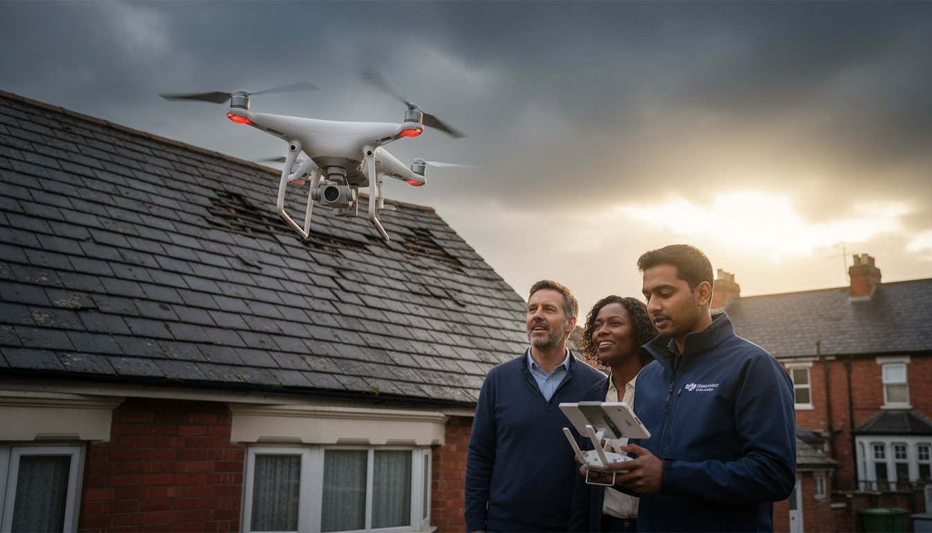
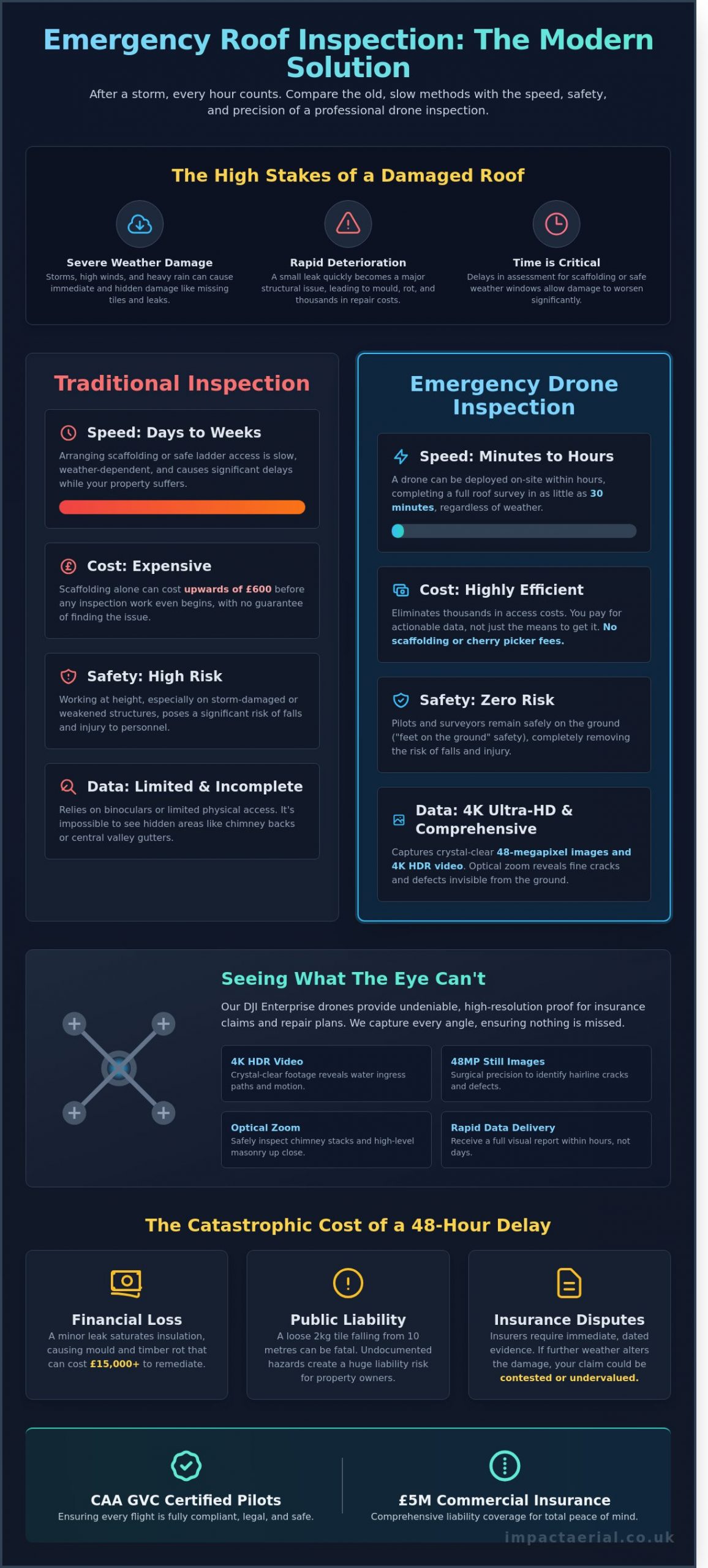
On a wet Tuesday morning after a severe Atlantic storm, you spot missing tiles and a spreading damp patch on your ceiling. You know that waiting for a traditional surveyor to erect scaffolding, which often costs upwards of £600 before the inspection even begins, risks turning a minor leak into a structural catastrophe. It’s stressful to feel like your property is deteriorating while you wait for a safe window to get a ladder up. You shouldn’t have to risk a fall or pay thousands in access fees just to see what’s happening on your own roof.
This is where a professional emergency drone roof inspection provides immediate peace of mind. Our CAA GVC Certified pilots at Impact Aerial utilize advanced 4K drone technology to deliver high-resolution clarity on your roof’s condition within minutes. You’ll get the precise visual evidence required for insurance claims without the safety risks of manual climbing. In the following guide, we’ll explain how aerial data gathering identifies hidden leaks, provides clear repair costings, and keeps your site fully operational during the assessment.
Key Takeaways
- Learn how rapid-response 4K aerial surveys provide immediate clarity on storm damage and structural failures without the need for manual climbing or ladders.
- Discover how DJI Enterprise optical zoom technology captures intricate details on chimney stacks and flashing that remain hidden from ground-level inspections.
- Understand the significant commercial advantages of an emergency drone roof inspection, which offers a deployment time of minutes compared to days for scaffolding.
- Identify the critical importance of CAA GVC certification and £5m commercial liability insurance to ensure your property assessment is fully compliant and safe.
- Explore how a professional end-to-end workflow from West Midlands-based experts provides peace of mind and high-resolution data delivery across the UK.
What is an Emergency Drone Roof Inspection?
An emergency drone roof inspection is a specialised, rapid-response aerial survey designed to assess property damage immediately after a disruptive event. Unlike scheduled maintenance, this service prioritises speed and safety, deploying CAA GVC Certified pilots to capture high-resolution data within hours of a request. We utilise the latest 4K High Dynamic Range (HDR) DJI Enterprise commercial drones to identify defects that are often invisible from ground level. This technology allows for a comprehensive visual record of a roof’s condition without the need for expensive scaffolding or risky ladder work.
The primary distinction between a standard survey and an emergency inspection lies in the time-sensitivity and the “snapshot” nature of the data. During the peak of the UK storm season in January 2024, response times became the deciding factor in preventing total roof failure for many commercial clients. By using drones, we provide “feet on the ground” safety for surveyors. This means professional assessors can review crystal-clear footage from a safe distance, avoiding weakened structures or unstable masonry. The integration of drone applications in infrastructure inspections has revolutionised how we handle these high-pressure scenarios; it turns a three-day manual setup into a 30-minute flight.
Our fleet is equipped to handle the most demanding environments. Whether it’s identifying a single displaced slate or mapping 500 square metres of storm-damaged factory roofing, the precision of 4K imagery ensures no detail is missed. For added peace of mind, every emergency drone roof inspection we conduct is backed by comprehensive commercial liability insurance, ensuring that the data-gathering process is as secure as it is efficient.
When to Call for an Emergency Aerial Survey
Timing is everything when the structural integrity of a building is compromised. You should request an emergency survey immediately following high-wind events, such as the 80mph gusts recorded during Storm Isha. Heavy snowfall also presents a unique risk in the UK; the weight can cause older industrial roofs to bow or crack. If you notice sudden water ingress, a drone can pinpoint the entry source 90% faster than manual inspection. Post-fire assessments are another critical area where manual access is strictly prohibited by health and safety regulations. In these cases, our drones provide the only safe method to view internal collapses from above.
The Critical Risks of Delayed Roof Inspections
Delaying an inspection by even 48 hours can lead to catastrophic financial consequences. A minor leak can saturate glass wool insulation within a day, leading to rapid mould growth and structural timber rot that might cost upwards of £15,000 to remediate. There’s also the pressing issue of public liability. Loose masonry or tiles weighing just 2kg can be fatal if they fall from a height of ten metres onto a public pavement. Finally, insurance companies often require immediate “snapshot” evidence. If secondary weather events alter the damage site before it’s documented, your claim could be contested or undervalued. Capturing high-quality, dated evidence ensures your baseline for repairs is indisputable.
The Technology: How Drones See What Binoculars Miss
Traditional roof surveys often rely on a surveyor standing at ground level with a pair of binoculars or a telephoto lens. This method is fundamentally limited by perspective and distance. Our professional fleet utilizes DJI Enterprise drones equipped with 4K High Dynamic Range (HDR) imaging sensors that provide a level of detail invisible to the naked eye. These 2026-standard sensors outperform traditional manual photography by capturing 48 million pixels of data per frame. This ensures that every centimetre of the roof is documented with surgical precision. When a building manager requires an emergency drone roof inspection, they aren’t just looking for a photo; they need actionable data that identifies the exact point of failure.
The transition from manual inspections to drone-led surveys has reduced inspection times by 75% for typical commercial properties. We don’t just fly over a building. We use advanced flight paths to create a comprehensive visual map of the entire structure. This process captures angles that are physically impossible to reach with ladders or even expensive cherry pickers. By positioning the drone at an 85-degree pitch directly above a valley gutter or behind a parapet wall, we reveal hidden debris and structural weaknesses that ground-based tools simply cannot see. Our pilots are CAA GVC Certified, ensuring every flight is conducted with the meticulousness required for high-stakes environments.
High-Resolution 4K and Thermal Imaging Capabilities
High-resolution 4K HDR video is the backbone of a modern survey. It allows our technical team to spot hairline cracks in lead work or microscopic fissures in concrete tiles that would otherwise lead to internal water damage. We look for the subtle signs of “ponding” on flat roofs, where water collects and adds weight to the structure. Beyond visible light, our thermal sensors identify moisture trapped beneath flat roof membranes. Because water retains heat longer than dry insulation, a thermal scan conducted at dusk reveals exactly where a leak has permeated the sub-structure. This data-gathering capability allows for targeted repairs, often saving clients over £3,000 in unnecessary full-roof replacements. For those managing multiple sites, you can view our full range of aerial survey options to see how this technology scales.
Zoom Technology and Safety Distances
Safety is the primary driver of our operational protocols. We maintain strict safety buffers while achieving macro-level detail through powerful 30x optical zoom technology. This allows us to inspect dangerous areas, such as unstable gables or storm-damaged chimney stacks, from a safe distance of 15 to 20 metres. We don’t need to touch the building or cause vibrations that might worsen a structural failure. While our operations are governed by the UK Civil Aviation Authority, we frequently cross-reference our safety management systems with international benchmarks, such as the FAA Part 107 regulations, to ensure our protocols meet global best practices for unmanned aircraft.
For large commercial warehouses exceeding 50,000 square feet, high-altitude overviews provide a perspective that helps identify systemic drainage issues across the entire roof plane. The drone can hover at a consistent altitude to produce a perfectly orthomosaic map, where hundreds of images are stitched together into one massive, zoomable file. This level of detail is essential during an emergency drone roof inspection following a storm, as it provides insurers with undeniable evidence of the damage. We provide a professional, authoritative record that serves as a single source of truth for contractors, insurers, and property owners alike.
Drone vs. Traditional Access: The Competitive Advantage
Speed is the most critical factor when a building’s envelope is compromised. Traditional roof surveys often require a 48-hour lead time just for the delivery of plant machinery or scaffolding components. In contrast, a CAA GVC Certified pilot can complete a pre-flight site assessment and have a drone airborne in under 15 minutes. This rapid deployment makes an emergency drone roof inspection the only viable choice for immediate damage assessment following a storm or structural failure.
Traditional access methods also bring significant logistical headaches for commercial property managers. Hiring a cherry picker or erecting scaffolding often necessitates closing car parks, blocking pedestrian pavements, or cordoning off large sections of a site. Drones operate from a small, controlled take-off zone, typically no larger than two square metres. This “zero-disruption” approach ensures that business operations continue as normal while high-resolution data-gathering takes place overhead. Recent industry shifts, as noted in a 2020 report by Forbes, show how these technologies revolutionize building inspections by providing safer, faster alternatives to manual labour at height.
Eliminating Scaffolding and Cherry Picker Lead Times
Insurance companies often include “mitigation of loss” clauses in commercial policies. If a leak occurs, the policyholder is legally required to take reasonable steps to prevent further damage. Waiting five days for a scaffolding permit from the local council can lead to internal water ingress that an insurer might refuse to cover. A single pilot replaces a three-person scaffolding crew, eliminating the wait for heavy vehicle transport and complex assembly. Beyond speed, the environmental impact is stark; battery-powered flight produces zero site emissions, whereas a 20-tonne diesel cherry picker consumes significant fuel just to reach the roofline.
Cost-Efficiency and ROI During a Crisis
Financial savings are often the most persuasive argument for switching to aerial surveys. In UK urban centres like Birmingham or London, pavement licences and hoarding permits can cost between £500 and £1,500 before any work begins. Using a drone can reduce the “access cost” portion of a survey bill by up to 70%. These savings allow property managers to allocate more budget toward the actual repairs rather than the equipment needed to see the damage. High-quality 4K imagery provides contractors with the exact measurements and visual evidence they need to provide fixed-price quotes, preventing the “hidden extras” that often appear once a builder climbs a ladder. Providing this level of precision offers clients peace of mind during high-pressure recovery phases.
The transition from manual inspections to aerial data collection represents a shift toward more meticulous, safety-conscious property management. By choosing an emergency drone roof inspection, stakeholders bypass the traditional bottlenecks of the construction industry. The combination of reduced liability, lower overheads, and immediate data delivery creates a competitive advantage that traditional methods simply cannot match. Every minute saved in the assessment phase is a minute gained in securing the building and protecting the assets within.
Compliance and Safety: Why Professional Certification Matters
Compliance isn’t a box-ticking exercise; it’s the foundation of every emergency drone roof inspection we conduct. When a storm hits or a leak appears, the urge to get eyes on the roof quickly shouldn’t bypass legal requirements. Operating a commercial drone in the UK involves strict adherence to Civil Aviation Authority (CAA) regulations. These rules exist to protect the public, your property, and the integrity of the data we collect. Without the correct permissions, any imagery captured may be inadmissible for insurance claims or legal disputes, potentially costing you thousands in rejected payouts.
Every commercial flight we undertake is backed by £5 million in specialist commercial liability insurance. This isn’t the standard cover found in hobbyist policies. It specifically complies with Regulation (EC) 785/2004, which mandates minimum insurance requirements for air carriers and aircraft operators. If an incident occurs during a survey, this level of cover ensures the client is fully protected against third-party property damage or injury. Professionalism means carrying the weight of that responsibility so you don’t have to.
The Importance of CAA GVC Certified Pilots
The distinction between a hobbyist and a professional is defined by the General Visual Line of Sight (GVC) certification. Since the CAA regulatory overhaul in January 2021, the GVC has become the gold standard for commercial remote pilots. This qualification allows us to operate more complex aircraft in residential and industrial environments. While a standard flyer must stay 150 metres away from residential areas, our GVC-certified pilots can operate much closer, providing the high-resolution detail required for a thorough emergency drone roof inspection in dense urban centres.
Managing Weather Constraints and Safety Protocols
Safety is a binary choice: it’s either safe to fly, or it isn’t. Our fleet of DJI Enterprise drones is engineered to withstand challenging conditions, but they have hard limits. For example, the DJI Mavic 3 Enterprise is rated for wind speeds up to 12 metres per second (approx 27mph). We monitor real-time MET Office aviation data and use ground-based anemometers to check local gusting before every take-off. If the conditions exceed these safety margins, we won’t fly. This disciplined approach is why we maintain a 100% safety record across all our survey projects.
Risk assessments are a non-negotiable part of our workflow. Before the drone even leaves its case, we evaluate the site for overhead wires, nesting birds, or high-intensity radio interference. In congested urban areas like Birmingham or Manchester, we often coordinate with local authorities or air traffic control if the site sits within a Flight Restriction Zone (FRZ). We handle all the paperwork and permissions, ensuring your survey is 100% legal. This meticulous planning provides the added peace of mind that your building survey is being handled by technical specialists who value precision over shortcuts.
Impact Aerial: Your Rapid Response Partner in the UK
Based in the heart of Birmingham and the West Midlands, Impact Aerial provides nationwide coverage for urgent aerial surveys. We understand that a leaking roof or structural failure doesn’t wait for a convenient appointment. Our team maintains constant readiness to deploy our fleet of DJI Enterprise drones across the UK. We hold full CAA GVC Certification and carry £5 million in commercial liability insurance. This ensures every emergency drone roof inspection we conduct meets the highest safety and legal standards. Property managers and site foremen rely on our technical expertise to mitigate risks immediately after a storm or fire.
Our Emergency Response and Data Delivery Workflow
We prioritise emergency enquiries to ensure a rapid turnaround. If you contact our team before 10:00 AM, we aim for same-day deployment; otherwise, we guarantee a next-day flight. Our end-to-end workflow is designed for speed without compromising on precision. Once the drone lands, the data-gathering phase transitions into our industry-leading post-production suite. We don’t just provide raw footage. We turn high-resolution imagery into actionable intelligence that property owners can use to make immediate decisions.
Clients receive their data through a secure, cloud-based platform. We often deliver these files within 4 hours of completing the flight. We don’t leave you with a mountain of unsorted files. We organise data into logical folders, such as “Lead Flashing,” “Valley Gutters,” and “Ridge Tiles.” This structure allows roofing contractors to identify defects in seconds rather than scrolling through hundreds of unsorted images, saving hours of administrative work.
Comprehensive Documentation for Insurance Claims
Accurate evidence is the foundation of any successful insurance claim. We provide date-stamped, 4K HDR footage that captures the minute details of storm damage or substrate failure. This clarity removes the ambiguity that often leads to claim disputes. Our high-resolution sensors capture 20-megapixel stills that show hairline cracks, shifted tiles, and loose fixings that a ground-based survey would miss. Professional drone data accelerates the claim approval process by providing irrefutable, high-definition evidence that eliminates the need for speculative manual assessments.
Loss adjusters require a clear audit trail to approve repairs. By providing a comprehensive digital record of the roof’s condition immediately following an incident, we help our clients secure the necessary funds for restoration. We support a wide range of property professionals, including:
- Commercial property developers managing large-scale industrial units.
- Construction firms requiring immediate site safety assessments.
- Insurers and loss adjusters seeking precise damage valuations.
- Facilities management teams overseeing schools and hospitals.
Our commitment to quality and compliance provides the peace of mind you need during a property crisis. We’ve built our reputation on being a meticulous and technologically adept partner. Whether you’re dealing with a single residential unit or a sprawling industrial complex, our emergency drone roof inspection service provides the breath-taking clarity and technical detail required for modern property maintenance. We are a trusted specialist in a niche but increasingly diverse market, dedicated to delivering top-quality results every time.
Secure Your Property with Rapid Aerial Intelligence
Waiting for scaffolding or manual surveys after a storm puts your building at risk of structural rot and costly interior damage. An emergency drone roof inspection bypasses these delays by deploying our DJI Enterprise 4K HDR fleet to capture high-resolution evidence of defects within minutes. You’ll receive clear data without the health and safety risks associated with working at height. Our operations are backed by £5m commercial liability insurance and conducted by CAA GVC certified pilots to ensure every flight meets strict UK aviation standards.
Precision matters when time is against you. We provide the technical expertise needed to document insurance claims and plan immediate repairs with total confidence. Don’t let a minor leak become a major structural failure. Our team is ready to provide the professional oversight and peace of mind your property deserves.
Contact Impact Aerial for an emergency roof inspection quote
Take the first step toward a safer, drier building today.
Frequently Asked Questions
How quickly can you attend an emergency drone roof inspection?
We aim to deploy a GVC certified pilot for an emergency drone roof inspection within 24 hours of your initial enquiry. Our team understands that structural failures or severe leaks require immediate visual data to prevent further internal damage. This rapid response is roughly 75% faster than traditional scaffolding companies, who typically require a 7-day lead time for installation and permits.
Can drones fly in rain or high winds for an inspection?
Our DJI Enterprise drones operate safely in wind speeds up to 22mph and light precipitation, but we ground flights during heavy rain or storm-force gusts. Safety is our primary concern to protect your property and our specialised equipment. If conditions exceed these limits, we reschedule for the next available weather window, which occurs in 90% of cases within a 24-hour period.
Is a drone roof survey as accurate as a physical inspection?
An emergency drone roof inspection is often more accurate than a manual survey because our 45-megapixel cameras capture details invisible to the naked eye. We identify hairline cracks as small as 1mm from a safe distance without stepping on fragile tiles. While a surveyor on a ladder has a limited field of vision, our drones provide a 360-degree perspective of every chimney stack and gutter.
Do I need to inform my neighbours before a drone inspection?
You should inform your neighbours as a matter of courtesy, although it isn’t a legal requirement if we remain within your property boundaries. We follow the Information Commissioner’s Office guidelines regarding privacy and data protection at all times. Our pilots ensure cameras are only active when pointed at the target structure. We provide a standard notification template for you to share with adjacent residents 24 hours before arrival.
What kind of report or data will I receive after the flight?
You’ll receive a comprehensive digital data pack including 4K video footage and high-resolution JPEG images within 24 hours of the flight. We also provide a detailed PDF inspection report that highlights specific defects with timestamped annotations. For complex projects, we can produce 3D orthomosaic maps consisting of over 500 individual images stitched together, allowing your contractor to zoom in with centimetre-level precision.
Are there any areas in the UK where drones cannot fly for inspections?
Drones cannot fly in Flight Restriction Zones near airports like Birmingham International or over sensitive sites like prisons without specific CAA authorisation. These zones cover approximately 2% of UK airspace. As professional operators, we handle all necessary permissions and airspace coordination. We check the NATS Drone Assist app for every location to ensure 100% legal compliance before taking off.
How much does an emergency drone roof inspection cost compared to scaffolding?
A drone inspection typically costs between £350 and £600, whereas scaffolding for a standard semi-detached house starts at £800 and often exceeds £1,500. You save roughly 60% on upfront costs by choosing an aerial survey. Beyond the financial saving, drones eliminate the risk of further roof damage caused by heavy equipment or foot traffic. We provide a fixed-price quote after reviewing your postcode.
Does insurance cover the cost of a drone roof survey?
Many UK commercial and residential insurers now accept or mandate drone surveys for claim processing. Since 2022, several leading providers have recognised aerial data as primary evidence for storm damage claims. You should check your specific policy, but providing high-resolution 4K imagery often speeds up the claims process by 50%. Our £5 million commercial liability insurance provides added peace of mind during the process.