
Navigating the planning permission process is one of the most significant hurdles for any UK developer. A submission built on incomplete or outdated site data can lead to costly delays, requests for more information, and even outright rejection from the local planning authority. Traditional ground surveys, while essential, are often slow, expensive, and can miss the crucial wider context of a site. This is where a professional uav survey for planning permission provides a decisive advantage, delivering high-resolution, accurate data that traditional methods simply cannot match.
This developer’s guide will demystify the process and demonstrate how advanced aerial data-gathering can transform your application. You will discover how the detailed topographic models, crystal-clear imagery, and comprehensive site overviews from a fully insured, CAA GVC Certified operator provide the critical evidence you need. Learn how to strengthen your planning application, reduce pre-planning phase timelines, and submit a robust, visually compelling case that significantly increases your chances of gaining a first-time approval.
Key Takeaways
- Understand how professional drone surveys provide a significant speed and cost-efficiency advantage over traditional surveying methods for development projects.
- Discover the specific, survey-grade data deliverables-such as high-resolution orthomosaics and 3D point clouds-that architects and planning authorities require.
- Learn how to integrate the precise data from a uav survey for planning permission directly into your reports to provide irrefutable evidence for your design proposals.
- Identify the essential CAA certifications and operational authorisations a UK drone operator must hold to ensure your survey data is legally compliant and professionally executed.
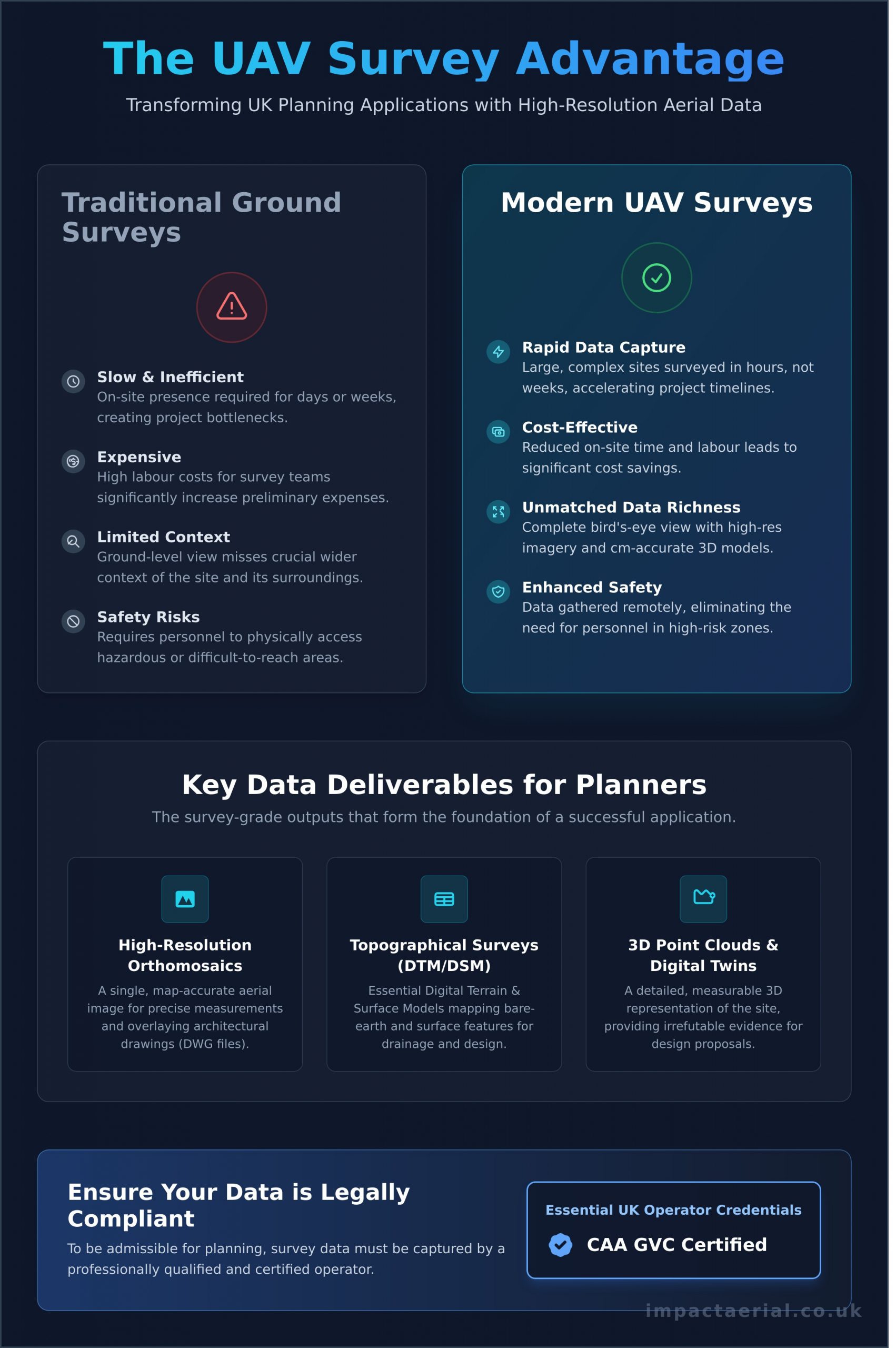
Why Use a UAV Survey for Your Planning Application?
Securing planning permission is a critical, often complex, stage of any development project. A successful application hinges on providing clear, accurate, and comprehensive information to the local planning authority. Traditionally, this involved extensive and costly ground-based surveys. Today, a professional uav survey for planning permission offers a decisive advantage, transforming how you present your project and communicate its impact.
This modern approach leverages advanced drone technology to create detailed site models and high-resolution imagery, providing a level of clarity that planning committees value. To see how this data is captured, this short video provides an excellent overview:
Speed and Cost-Effectiveness
Traditional land surveys can be a significant bottleneck, requiring teams of surveyors on-site for days or even weeks. A UAV survey dramatically reduces this timeframe, capturing data for large or complex sites in a matter of hours. This efficiency translates directly into lower labour costs and a faster path to submitting your application, accelerating your entire project timeline and potentially saving thousands of pounds in preliminary expenses.
Unmatched Data Richness and Context
A key limitation of ground-based methods is their inability to capture the full context of a site. Our UAVs collect vast amounts of data, producing not only centimetre-accurate topographical maps but also high-resolution aerial imagery of the entire site and its surroundings. By using sophisticated photogrammetric survey techniques, we create a detailed digital twin of your site. This ‘bird’s-eye view’ is invaluable for planning officers, allowing them to instantly understand the proposal in relation to neighbouring properties, access routes, and local topography.
Enhanced Safety and Accessibility
Site safety is paramount. A uav survey for planning permission mitigates significant risks by removing the need for personnel to access hazardous or difficult-to-reach areas on foot. This includes surveying unstable ground, steep embankments, fragile rooftops, or active industrial sites without disruption or danger. Our CAA GVC certified pilots can operate safely and efficiently, gathering essential data while minimising risk and ensuring full compliance with health and safety regulations, providing you with added peace of mind.
Key Data Deliverables from a Drone Survey for Planners
To secure a successful planning application, architects and local authorities require precise, verifiable data, not just illustrative photographs. A professional uav survey for planning permission delivers a suite of survey-grade outputs that form the digital foundation of your entire project. This data is captured by CAA-certified pilots operating in strict accordance with UK drone regulations, ensuring it is both accurate and admissible. These deliverables allow you to visualise, measure, and plan your development with an unparalleled level of detail and confidence before breaking ground.
High-Resolution Orthomosaic Maps
An orthomosaic map is a single, geometrically corrected aerial image of your entire site, created by stitching together hundreds or thousands of high-resolution photos. Unlike a standard photograph, it is map-accurate, meaning every pixel is in its true geographic position. This allows architects and planners to perform precise measurements of distances, areas, and perimeters directly from the image. Its primary uses include:
- Initial site layout and feasibility studies.
- Accurate boundary confirmation against existing land registry plans.
- Overlaying architectural drawings (e.g., DWG files) to visualise the proposed development in situ and identify potential conflicts with existing features.
Topographical Surveys (DTM & DSM)
Understanding the site’s elevation and contours is fundamental to almost every aspect of planning. A UAV survey produces two critical topographical models. A Digital Terrain Model (DTM) maps the bare-earth surface, stripping away all buildings and vegetation, which is vital for accurate drainage design and flood risk assessments. A Digital Surface Model (DSM) includes these surface features, providing a complete picture of the site as it currently exists. This data is crucial for cut-and-fill calculations, sightline analysis, and creating the foundational CAD drawings for the project.
3D Point Clouds and Digital Twins
The most comprehensive deliverable is the 3D point cloud-a dense collection of millions of data points that create a precise, photorealistic 3D model of your site and its surroundings. This “digital twin” can be navigated, measured, and analysed from any angle, offering profound insight into the existing environment. This model integrates seamlessly with Building Information Modelling (BIM) and CAD software, allowing for advanced design work and clash detection. For planning committees and stakeholders, it provides an invaluable tool to fully understand the scale, massing, and visual impact of the proposed development.
How UAV Data Directly Strengthens Planning Application Documents
A successful planning application is built on a foundation of irrefutable evidence. While the benefits of a UAV survey are clear in theory, its true value is realised when the data is directly applied to the required paperwork. This high-resolution data allows you to provide verifiable proof for your design choices, proactively address potential objections from planning officers, and demonstrate an exceptionally thorough and professional approach from the outset.
Informing the Design and Access Statement
This critical document explains the rationale behind your proposal, and UAV data provides the visual and contextual evidence to support your narrative. High-quality aerial photographs and 3D models allow you to:
- Justify the proposed scale and massing by showing it in context with the surrounding built environment.
- Clearly illustrate how the design relates to neighbouring properties, boundaries, and the wider landscape.
- Demonstrate proposed access routes and their impact on the public realm with real-world clarity.
- Provide an accurate visual baseline for any required Landscape and Visual Impact Assessments (LVIA).
Creating Accurate Site and Block Plans
The precision of your submitted plans is non-negotiable. The data from a professional uav survey for planning permission provides the definitive, centimetre-accurate base map upon which all architectural drawings are built. This ensures that every element-from topographical features and existing structures to precise boundary lines-is correctly represented. Submitting plans based on this level of accuracy to the planning portal significantly reduces the risk of validation errors and costly delays caused by requests for further information.
Supporting Environmental and Arboricultural Reports
Modern planning applications place a heavy emphasis on environmental considerations. A UAV survey delivers the crucial baseline data needed for specialist consultants to produce robust reports. This includes accurately mapping tree locations, canopy spreads, and root protection areas for arboricultural assessments. Furthermore, the survey can identify watercourses, assess potential flood plains, and provide the foundational data for complex ecological surveys and Biodiversity Net Gain (BNG) calculations.
Ensure your application is backed by expert data.
Choosing a Compliant UK Drone Survey Provider: A Checklist
Securing accurate data for your planning application depends entirely on the quality of your chosen provider. The UK drone market includes many operators, but not all are qualified or equipped to perform the high-precision, survey-grade work required for architectural and construction projects. Using an uncertified or uninsured operator not only yields poor data but also exposes your project to significant legal and financial risks. This checklist will help you verify a provider’s credentials and ensure they are a suitable partner.
Essential CAA Certification and Permissions
In the UK, all commercial drone operations are regulated by the Civil Aviation Authority (CAA). It is a legal requirement for any professional drone pilot to hold current certification. Before engaging a provider, you must verify they have:
- A General Visual Line of Sight Certificate (GVC), which proves the pilot has the required competency and safety knowledge.
- A valid Operational Authorisation issued by the CAA, which permits them to fly commercially.
These documents are non-negotiable. Always ask for copies for your records to ensure your project is fully compliant.
Adequate Commercial Insurance
For your protection and for added peace of mind, confirm your provider holds specialist commercial drone insurance, not a standard hobbyist policy. Look for a public liability coverage of at least £5 million. This insurance protects you, your site, and the public in the unlikely event of an incident. Request to see their insurance certificate before any work commences on your property.
Professional-Grade Equipment and Software
The accuracy of a uav survey for planning permission is determined by the technology used. Hobby-grade drones are unsuitable for this task. A professional surveyor will use enterprise-level equipment and processes, including:
- Survey-Grade Drones: Professional models equipped with high-resolution sensors, designed for precise data capture.
- Advanced Processing Software: Photogrammetry software like Pix4D or Agisoft Metashape is essential for creating accurate 3D models and orthomosaic maps.
- Ground Control Points (GCPs): A reputable provider will use accurately measured GCPs to georeference the aerial data, ensuring centimetre-level precision that planning authorities and architects require.
Proven Industry Experience
Finally, look for a provider with a portfolio of work in the property, construction, or architectural sectors. A specialist survey company understands the specific outputs needed for planning applications, such as topographical surveys, 3D point clouds, and detailed elevation models. Ask for case studies or references from similar projects to confirm their expertise. An experienced operator will be a valuable partner in your project, not just a service provider.
Impact Aerial is a fully certified and insured commercial drone operator with extensive experience in delivering survey-grade data for development projects. See our credentials and why we are a trusted partner.
Elevate Your Planning Application with a Professional UAV Survey
In today’s competitive development landscape, the quality of your supporting data can be the deciding factor between approval and rejection. As we’ve explored, UAV surveys deliver unparalleled topographic accuracy and rich contextual imagery, directly strengthening planning documents and satisfying council requirements. Choosing a compliant, expert provider is therefore crucial to leveraging this technology effectively and ensuring your data is both reliable and admissible.
Ultimately, a professional uav survey for planning permission is a strategic investment in the success of your project. At Impact Aerial, we are specialists in property and construction surveys, using survey-grade DJI Enterprise drones to deliver the precise data you need. As a CAA GVC Certified and fully insured operator, we provide the technical expertise and regulatory peace of mind your development deserves.
Ready to build a robust, data-driven application that stands out? Get a precise quote for your planning permission survey. Take the first step towards securing your project’s approval with confidence.
Frequently Asked Questions About UAV Surveys for Planning
How accurate is a UAV survey for planning purposes?
Our UAV surveys are exceptionally accurate, achieving survey-grade precision suitable for all planning and architectural requirements. By utilising advanced drones equipped with RTK (Real-Time Kinematic) or PPK (Post-Processed Kinematic) GPS technology, combined with a network of Ground Control Points (GCPs), we consistently deliver data with an absolute accuracy of 20-40mm. This high-resolution, georeferenced data ensures your plans are based on a precise digital representation of the site, minimising risks and costly errors.
Is data from a drone survey accepted by UK local planning authorities?
Yes, absolutely. High-quality data from a professional UAV survey is widely accepted and often preferred by local planning authorities across the UK. The key is ensuring the data is captured and processed to recognised industry standards by a qualified and insured operator. The detailed topographical maps, 3D models, and high-resolution imagery we produce provide planners with a comprehensive and unambiguous view of the site and its context, which can significantly streamline the application process.
How much does a UAV survey for a planning application cost?
The cost of a UAV survey for a planning application is project-specific and depends on several key factors. A survey for a small, straightforward site typically starts from around £650. The final price is influenced by the size and complexity of the area, the required deliverables (e.g., 2D topographical plan vs. a detailed 3D point cloud), and the site’s location and any associated airspace restrictions. We provide a detailed, no-obligation quotation tailored to your exact project needs.
How long does the entire drone survey process take from flight to data delivery?
The entire process is efficient and designed to meet project deadlines. The initial pre-flight planning, including risk assessments and airspace checks, takes 1-2 days. The on-site data capture is typically completed within a few hours to a single day. Following the flight, data processing and quality assurance to produce the final deliverables, such as CAD-ready files or 3D models, usually takes between 3 to 7 working days, depending on the complexity of the data set.
Can drone surveys be conducted in any weather or location?
Operations are dependent on suitable weather conditions. We cannot fly in rain, strong winds (typically above 22 mph), or fog for safety and data quality reasons. Regarding location, as CAA GVC Certified operators, we are qualified to operate in most environments, including congested urban areas. However, flights near airports or other restricted zones require specific authorisations. Our professional services include managing all necessary pre-flight checks and permissions to ensure a safe and compliant operation.
What information do I need to provide to the drone survey company?
To provide an accurate quotation and conduct a successful survey, we require a few key details. Please provide the site location, ideally with a clear boundary file (such as a KML or site plan). We also need to know the specific outputs you require for your planning application (e.g., topographical survey, 3D model, orthophoto). Finally, please inform us of any known site access restrictions or potential hazards we should be aware of before our arrival.