Commissioning a professional drone survey in Birmingham for your projects can be a complex task. From deciphering which type of aerial data you need to navigating the challenge of finding a legally compliant and insured operator in the region’s diverse airspace, the path to actionable insights is often unclear. Many project managers worry about safety, privacy, and the crucial difference between a hobbyist and a truly professional, CAA GVC Certified pilot, which can make or break a project’s success and legality.
This comprehensive 2026 guide is designed to provide complete clarity and peace of mind. We will break down the various types of professional drone surveys, from thermal imaging to topographic mapping, ensuring you can select the right service for your specific requirements. You will learn exactly how to vet a provider, what to look for in terms of certification and insurance, and what to expect from the data-gathering process. By the end, you’ll have the confidence to save time and money by hiring the right team for a safe, efficient, and high-quality aerial survey.
Why Use a Drone Survey in London? Key Advantages Over Traditional Methods
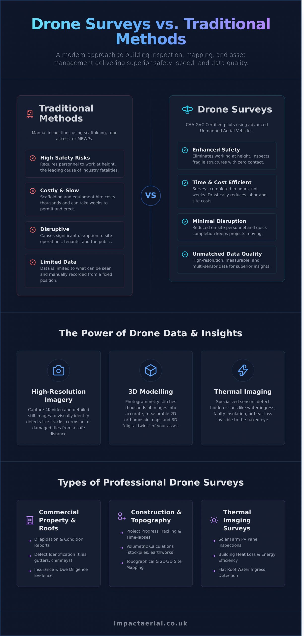
In a dense and complex urban environment like London, traditional building inspection methods such as scaffolding, rope access, or mobile elevated work platforms (MEWPs) are often slow, disruptive, and expensive. A professional drone survey provides a superior alternative, leveraging advanced technology to deliver faster, safer, and more cost-effective results. By using a sophisticated Unmanned Aerial Vehicle (UAV), our certified pilots can capture comprehensive data without the significant logistical challenges and safety risks associated with manual inspections.
To see how this technology is applied on a large scale, the video below demonstrates a major UK asset inspection project:
Enhanced Safety for London Projects
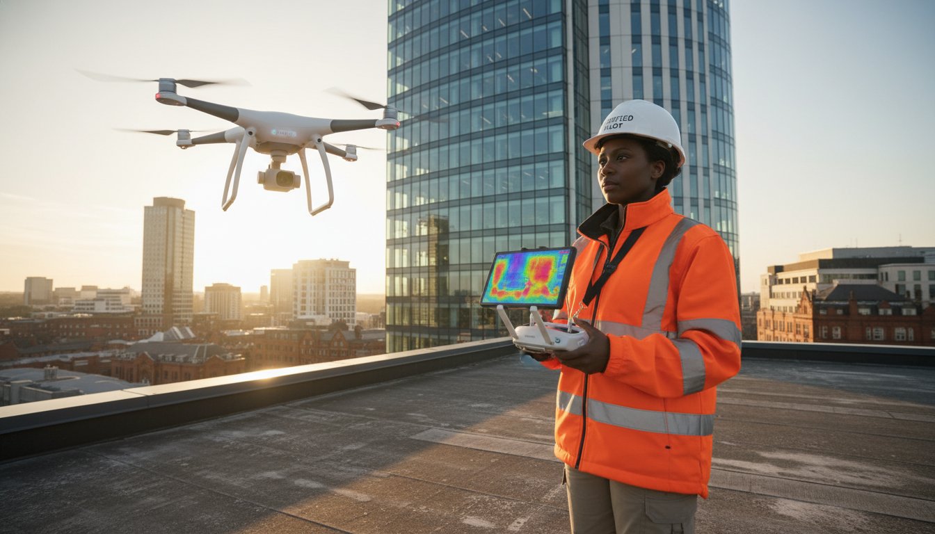
Safety is the most critical advantage. A drone survey fundamentally eliminates the need for personnel to work at height, mitigating one of the biggest risks in the construction and maintenance industries. For a busy drone survey London construction sites require minimal on-site personnel, reducing foot traffic and potential hazards. Furthermore, drones can inspect delicate or fragile structures, such as the roofs of heritage buildings or listed properties, without any physical contact, ensuring their preservation while gathering essential condition data.
Cost and Time Efficiency
The financial and operational benefits are substantial. Hiring, erecting, and dismantling scaffolding in London can cost thousands of pounds and take weeks, including the time required for permits. A drone survey is completed in a matter of hours, drastically reducing labour costs and site disruption. This speed translates directly into project efficiency, as the rapid data turnaround allows project managers, architects, and surveyors to make informed decisions without delay, keeping the project on schedule and on budget.
Unmatched Data Quality and Insights
Drones are equipped with high-specification cameras and sensors that capture data of exceptional quality. This includes:
- High-Resolution Imagery: 4K video and high-resolution still images allow for detailed visual analysis, enabling experts to identify defects like cracks, corrosion, or damaged tiles from a safe distance.
- 3D Modelling: Using a process called photogrammetry, thousands of images are stitched together to create highly accurate and measurable 2D maps and 3D digital twins of your asset.
- Thermal Imaging: Specialised thermal sensors can detect hidden issues invisible to the naked eye, such as water ingress beneath a flat roof, faulty insulation, or heat loss from a building envelope.
Types of Drone Surveys Available in London (Beyond Just Roofs)
While roof inspections are a common application, the scope of a professional drone survey in London extends far beyond simple visual checks. Our advanced data-gathering services provide actionable intelligence for a diverse range of commercial sectors, from construction to asset management. Operating safely and effectively in the capital’s complex airspace requires meticulous planning and full compliance with regulations set by the UK Civil Aviation Authority (CAA), ensuring every mission is conducted to the highest professional standard for your peace of mind.
Commercial Property and Roof Surveys
For property managers, asset owners, and RICS surveyors, our drones provide rapid, safe access to high-level and difficult-to-reach areas of a building’s fabric. We deliver high-resolution imagery and detailed reports that form a critical part of building management, due diligence, and maintenance planning.
- Dilapidation and Condition Reports: Capture detailed evidence for end-of-tenancy assessments and planned preventative maintenance (PPM) schedules.
- Defect Identification: Clearly identify issues such as damaged tiles, blocked gutters, chimney stack deterioration, and compromised flashing.
- Insurance and Surveying Evidence: Provide verifiable photographic and video evidence to support insurance claims and supplement traditional building surveys.
Construction Site Monitoring and Topographical Surveys
On a dynamic construction site, our services offer a comprehensive overview that ground-level perspectives cannot match. We provide construction firms with accurate, repeatable data to enhance project management, improve site safety, and control costs throughout the project lifecycle.
- Progress Tracking: Monitor project milestones with regular aerial progress reports and compelling time-lapse videos for stakeholders.
- Volumetric Calculations: Perform precise calculations for stockpiles and earthworks, essential for inventory management and progress billing.
- Topographical Mapping: Generate detailed 2D orthomosaic maps and 3D digital elevation models for accurate site planning and design verification.
Thermal Imaging Surveys
Equipped with radiometric thermal cameras, our drones can detect temperature variations invisible to the naked eye. This non-invasive technology is invaluable for preventative maintenance and energy efficiency assessments across various commercial assets.
- Solar Farm Inspections: Quickly scan large-scale solar installations to identify defective PV panels, cell faults, and connection issues that reduce overall efficiency.
- Building Energy Efficiency: Analyse building envelopes to pinpoint thermal bridges and areas of significant heat loss, informing energy-saving retrofits.
- Water Ingress Detection: Identify moisture trapped within flat roofing systems by detecting temperature differentials, allowing for targeted repairs before major structural damage occurs.
Choosing a Drone Survey Company in London: A 5-Point Checklist
Selecting the right partner for your drone survey London project is critical for ensuring safety, compliance, and high-quality data. The capital’s congested airspace and complex regulations mean that only the most professional and meticulous operators should be considered. Use this checklist to vet potential providers and ensure you are working with a competent, fully-certified company.
1. Verify CAA GVC Certification and Permissions
This is a non-negotiable starting point. The General Visual Line of Sight Certificate (GVC) is the standard commercial qualification issued by the Civil Aviation Authority (CAA) for professional drone operations in the UK. It proves the pilot has demonstrated the required competency and safety knowledge. Always ask to see a copy of the company’s Operational Authorisation and ensure their Operations Manual is up-to-date, as this document outlines the specific procedures they must follow to comply with UK drone flying regulations.
2. Confirm Adequate Commercial Insurance
For added peace of mind, a professional drone survey company must hold comprehensive commercial liability insurance. The industry standard is a policy with at least £5 million in coverage. This protects your project, property, and the public from any potential damage or injury during flight operations. Be wary of operators with only recreational-level insurance, as it is entirely inadequate for commercial work and leaves you exposed to significant risk.
3. Assess Their Equipment and Technology
The quality of your survey data is directly linked to the quality of the equipment used. Ask about their drone fleet. A professional provider will use enterprise-grade platforms, such as the DJI Enterprise series, not off-the-shelf consumer models. These systems are equipped with high-resolution cameras, specialised sensors (like thermal or LiDAR), and crucial redundancy features for enhanced safety. Enquire about their maintenance logs to ensure the equipment is impeccably maintained.
4. Review Their Experience and Portfolio
Theory is one thing; practical experience is another. A reputable provider will have a strong portfolio of completed projects, ideally including work in London or other complex urban environments. Look for case studies and client testimonials from relevant industries like construction, asset management, or architecture. Their experience navigating the capital’s unique flight restriction zones and obtaining necessary permissions is invaluable. View our portfolio of successful UK-wide aerial projects.
5. Scrutinise Their Safety and Planning Process
A true professional’s commitment to safety goes far beyond their certificate. Ask about their pre-flight planning process. This should include detailed site surveys, airspace analysis, and the creation of a robust Risk Assessment and Method Statement (RAMS). This meticulous planning demonstrates a proactive approach to safety and is a clear indicator of a company that prioritises safe, compliant, and successful operations above all else.
Navigating London’s Airspace: Regulations and Challenges
Conducting a drone survey in London presents a unique set of regulatory and logistical challenges unmatched elsewhere in the UK. The capital’s dense urban environment and complex airspace demand a level of expertise that goes far beyond standard CAA certification. A professional operator not only possesses the technical skill to capture high-quality data but also the procedural diligence to navigate this demanding landscape safely and legally, providing complete peace of mind.
Understanding Controlled Airspace
Central London is situated beneath some of the world’s busiest controlled airspace, with flight paths for major airports like Heathrow, Gatwick, and London City creating a complex, layered system. Operating a drone here requires meticulous planning and direct coordination with Air Traffic Control (NATS). Professional operators are adept at submitting detailed flight plans and obtaining the necessary non-standard flight approvals. Attempting to fly without this authorisation is not only illegal, carrying severe penalties, but also poses a significant risk to manned aviation.
Local Borough and Council Permissions
Beyond national aviation law, many of London’s 32 boroughs have specific by-laws governing the use of drones, particularly regarding take-off and landing on council-owned land. This includes most parks, public squares, and green spaces. A crucial part of pre-flight planning for any drone survey London project involves:
- Identifying the specific borough and its drone policy.
- Applying for any required permits or permissions, which can take several weeks.
- Liaising with property managers and local authorities to ensure full compliance.
This granular, localised knowledge is a hallmark of an experienced London-based drone survey provider.
Privacy and Data Protection (GDPR)
Operating drones in a densely populated city raises valid concerns about public privacy. As a professional, CAA GVC certified operator, we mitigate these risks through rigorous planning and transparent operations. Flight paths are designed to minimise overflight of private residential properties, and we adhere strictly to GDPR when handling any captured data that may contain identifiable information. Our commitment to ethical data-gathering ensures your project respects legal frameworks and maintains public trust. This meticulous approach is central to the professional services offered by Impact Aerial.
The Drone Survey Process: What to Expect Step-by-Step
Understanding the workflow behind a professional drone survey provides confidence and clarity. At Impact Aerial, we follow a meticulous, four-step process designed for safety, efficiency, and delivering high-quality, actionable data. This structured approach ensures every project, from a complex roof inspection to a large-scale topographical survey, is executed to the highest industry standards.
Step 1: Initial Consultation and Scoping
Every successful project begins with a clear understanding of your objectives. This initial phase is a collaborative discussion where we establish the precise requirements for your project. We focus on:
- Discussing Your Goals: We listen to your needs to understand the desired outcomes and the specific challenges you face.
- Defining the Scope: We determine the exact area to be surveyed and the specific data sets required, whether it’s thermal imagery, high-resolution photographs, or photogrammetry data.
- Providing a Quotation: Based on the defined scope, we provide a detailed, transparent, and no-obligation quotation for the work.
Step 2: Pre-Flight Planning and Risk Assessment
Safety and compliance are paramount. Before our pilot arrives on site, we conduct comprehensive planning. This critical stage involves detailed desktop surveys of the location to identify potential hazards, flight restrictions, and ground conditions. If you need a drone survey in London or another congested area, this includes submitting applications for any necessary airspace permissions from the CAA. We then create a detailed flight plan and method statement to ensure a safe and efficient operation.
Step 3: On-Site Survey and Data Capture
On the scheduled day, our fully qualified and CAA GVC Certified pilot will arrive on-site to conduct the survey. The on-site process is methodical and professional, starting with a safety briefing for all relevant personnel. The flight area is secured, and pre-flight checks are completed before the mission is executed. Using advanced commercial drones, our pilot follows the pre-approved flight plan to capture precise, high-quality data with minimal disruption to your operations.
Step 4: Data Processing and Delivery
Once the flight is complete, the raw data is transferred to our processing suite. Here, our specialists transform the captured imagery and measurements into the final, usable deliverables. This could be a detailed PDF inspection report with annotated images, an accurate 2D orthomosaic map, or a fully interactive 3D model. The final data package is delivered to you via a secure cloud platform, and we remain available to discuss the findings and ensure you can fully leverage the insights provided.
Ready to see how our professional process can benefit your project? Start your London drone survey project with a free consultation.
Elevate Your London Project with a Professional Drone Survey
As we have explored, the landscape of property and asset management in London is being transformed by drone technology. By offering superior safety, significant cost savings, and rapid data acquisition compared to traditional methods, the benefits are clear. The key is partnering with a provider who can navigate the capital’s unique regulatory environment to deliver high-quality, actionable insights for projects of any scale.
When you require a professional drone survey london, choosing a certified and experienced operator is critical. At Impact Aerial, our team provides more than just data; we deliver confidence. Our CAA GVC Certified and fully insured pilots possess proven experience in London’s complex airspace, ensuring every operation is conducted safely and to the highest professional standards, giving you complete peace of mind.
Ready to see your project from a new perspective? Request Your No-Obligation London Drone Survey Quote today. Take the first step towards a safer, faster, and more detailed understanding of your assets.
Frequently Asked Questions About Drone Surveys
How much does a drone survey in London typically cost?
The cost of a drone survey in London is determined by project complexity, site accessibility, and the specific data required. A basic roof inspection may start from £350-£500, while complex topographical or photogrammetry surveys can be significantly more. We provide a detailed, itemised quotation after a thorough pre-site assessment to ensure transparent pricing, guaranteeing you only pay for the precise services your project needs.
How long does it take to get the results from a drone survey?
The turnaround for survey results depends on the complexity of the data processing. For straightforward visual inspections, you can often receive high-resolution images and video within 24-48 hours. More detailed outputs, such as 2D orthomosaic maps or 3D models from photogrammetry data, typically require 3-7 working days for processing and analysis. We always provide a clear project timeline, ensuring you know exactly when to expect your deliverables.
Is it safe and legal to fly drones in central London for a survey?
Yes, it is both safe and legal when conducted by a fully qualified and certified operator. Flying in congested areas requires special permissions from the Civil Aviation Authority (CAA) and meticulous planning, including comprehensive risk assessments. As CAA GVC Certified operators with extensive public liability insurance, we manage all necessary authorisations to ensure every drone survey in London is conducted in full compliance with UK regulations, providing complete peace of mind.
What kind of report or data will I receive after the survey?
The deliverables are tailored to your project’s specific requirements. This can range from a set of high-resolution 4K video clips and annotated still photographs for a visual inspection to highly detailed technical data. For more advanced surveys, we provide outputs such as 2D orthomosaic maps, 3D point cloud models, and digital elevation models (DEMs). Each report is professionally compiled to deliver clear, actionable insights for your business.
Do I need to get permission from neighbours for a drone survey?
While there is no legal requirement to obtain permission, we consider it best practice to inform neighbours as a courtesy, especially in residential areas. This helps manage expectations and ensures a smooth operation. As part of our professional pre-flight planning, we identify any potential privacy concerns and operate strictly within CAA guidelines, ensuring our data-gathering is focused solely on the target site and respects the privacy of adjacent properties.
Can you fly drones in bad weather like rain or high winds?
For safety and data quality reasons, we do not operate our commercial drones in rain or high winds. Most enterprise-level drones have a maximum wind resistance limit, and rain can damage sensitive electronics and compromise image quality. If adverse weather is forecast, we will proactively communicate with you to reschedule the survey for the next suitable day at no additional cost, ensuring optimal and safe operating conditions for a top-quality result.