
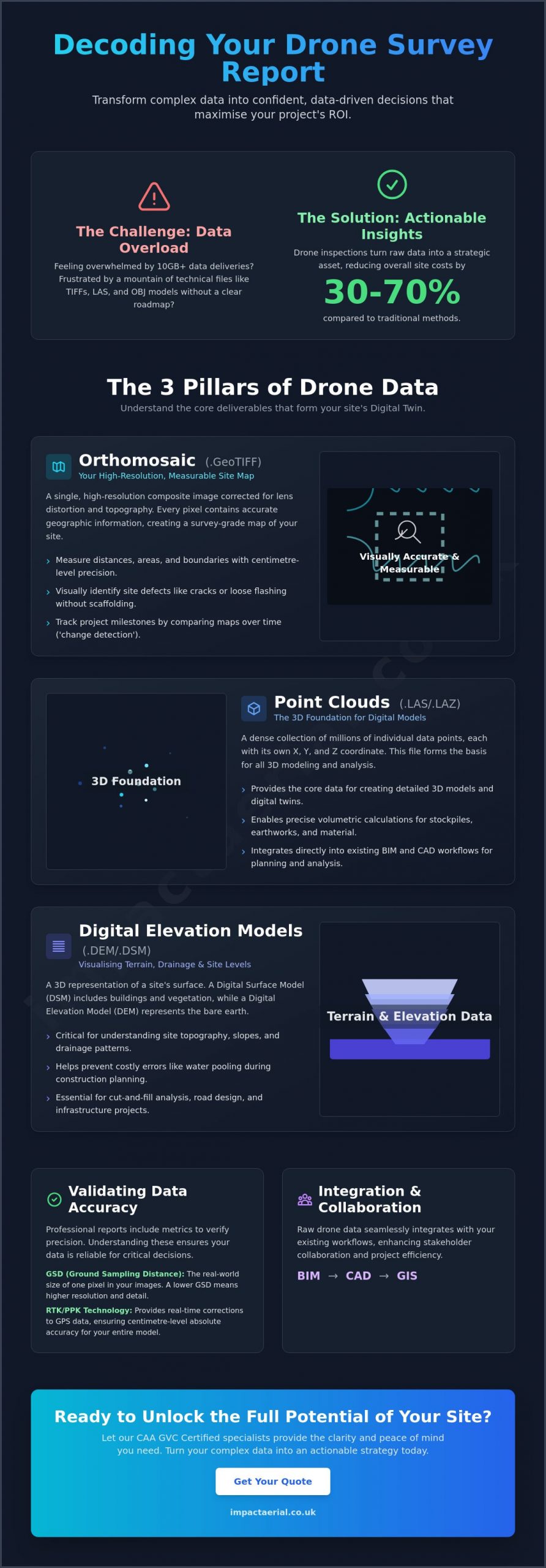
Recent industry data shows that drone inspections can reduce overall site costs by 30-70%, yet many commercial managers find themselves overwhelmed by the resulting 10GB data delivery. It’s common to feel frustrated when a high-tech solution produces a mountain of files like TIFFs, LAS point clouds, and OBJ models without a clear roadmap. The true challenge isn’t the flight itself; it’s understanding your drone survey report well enough to make confident, data-driven decisions on-site.
We agree that technical data shouldn’t be a barrier to progress. As CAA GVC Certified specialists, we know that professional aerial services must provide clarity and peace of mind rather than just raw numbers. This guide will teach you how to decode complex photogrammetry and turn technical outputs into a prioritised maintenance or construction plan. We’ll preview how to identify site defects accurately and use volumetric measurements to justify costs to your stakeholders. By the end, you’ll have the tools to transform technical files into a strategic asset that maximises your project ROI.
Key Takeaways
- Learn to distinguish between orthomosaic maps and 3D point clouds to accurately measure site distances and material volumes.
- Master understanding your drone survey report by identifying the metadata and GPS tagging that transform aerial images into precise datasets.
- Discover how to use digital twins for construction monitoring and property inspections to identify defects without the high cost of scaffolding.
- Understand technical metrics like Ground Sampling Distance (GSD) and the role of RTK to verify the absolute accuracy of your survey data.
- Find out how to integrate raw drone data into your existing BIM or CAD workflows to improve stakeholder collaboration and project ROI.
What is a Drone Survey Report? Beyond Standard Photography
A drone survey report is far more than a collection of high-resolution pictures. While standard aerial photography captures a moment in time, a professional survey report represents a transition into geometrically corrected data sets that offer measurable insights. By using advanced photogrammetry, we convert hundreds of individual images into a single, cohesive model where every pixel contains geographic information. This process relies heavily on metadata, GPS tagging, and detailed flight logs to ensure that the data is not only visual but also spatially accurate.
At Impact Aerial, we deploy state-of-the-art commercial drones capable of capturing 4K High Dynamic Range (HDR) imagery. This hardware ensures that even in challenging lighting conditions, the data-gathering process remains precise and reliable. Ultimately, a drone survey report is a comprehensive digital twin of a physical asset.
To better understand how these data layers are constructed, watch this helpful video:
Visual Data vs. Geospatial Deliverables
The strength of a drone survey lies in its dual-purpose output. High-resolution 4K imagery allows for detailed visual inspections, enabling your team to identify specific defects like hairline cracks or loose flashing without the need for expensive scaffolding or complex RAMS. However, the geospatial data is what enables accurate measurements and 3D modelling. These two data types work together to provide peace of mind during site assessments, ensuring that you aren’t just looking at a problem, but measuring its exact scale and location. This combination is why drone inspections can reduce overall inspection costs by 30-70% compared to traditional methods.
Common File Formats You Will Encounter
Gaining a full understanding your drone survey report requires familiarity with the specific file types delivered by our CAA GVC Certified pilots:
- Orthomosaic (GeoTIFF): This is a high-resolution, measurable map of your site. It is corrected for lens distortion and topographic relief, allowing you to measure distances and areas directly on the image with centimetre-level precision.
- Point Clouds (LAS/LAZ): These files consist of millions of individual data points in a 3D space. They form the 3D foundation for BIM and CAD integration, allowing for detailed structural analysis and project planning.
- Digital Elevation Models (DEM): These are essential for visualising terrain and drainage patterns. They help project managers understand site levels to prevent water pooling or planning errors during the early stages of construction.
Interpreting the 3 Main Pillars of Drone Data
The true commercial power of understanding your drone survey report lies in how you layer different data types to reveal site conditions. A single survey provides a detailed baseline, but the most significant value often comes from ‘change detection’. By comparing datasets from different dates, project managers can track construction progress or monitor the degradation of assets with surgical precision. This multi-layered approach ensures that stakeholders have a complete digital twin of their property, moving beyond simple visuals into actionable intelligence.
Whether you are looking for volumetric data or identifying structural weaknesses, these three pillars provide the technical foundation needed for informed decision-making. If you require assistance in setting up a monitoring schedule, our team can help you optimise your data strategy to ensure long-term asset health.
Orthomosaics: Your High-Resolution Site Map
Unlike standard photos, an orthomosaic is a composite image where every pixel is corrected for perspective and lens distortion. This process ensures the map is uniform across its entire area, allowing for survey-grade accuracy when measuring distances or site boundaries. You can use digital annotation tools to highlight specific defects or mark out safety zones. Comparing current maps with previous surveys is the most effective way to track project milestones and verify that work aligns with CAD designs.
Digital Elevation and Surface Models (DEM/DSM)
Elevation models are critical for site planning. A Digital Surface Model (DSM) captures everything on the site, including equipment and structures, while a Digital Elevation Model (DEM) provides a ‘bare earth’ view by filtering out objects. This distinction is vital for drainage planning and flood risk assessments. In the construction sector, 3D terrain data allows for rapid calculation of stockpile volumes. Instead of manual ground measurements, drones can calculate the volume of material moved with over 95% accuracy in a fraction of the time.
Thermal Imagery for Specialised Surveys
For energy and utility sectors, PV solar farm thermal surveys are indispensable. These reports use radiometric data to provide precise temperature readings for every pixel. By reading thermal gradients, we can identify ‘hot spots’ that indicate failing cells, electrical faults, or moisture ingress in roofing. Identifying these issues early prevents costly downtime and ensures that assets operate at peak efficiency. Relying on professional data-gathering provides the peace of mind that your maintenance plan is based on empirical evidence rather than guesswork.
Industry-Specific Insights: What the Data Means for You
The true commercial value of understanding your drone survey report lies in its application to your specific business challenges. While the technical pillars provide the “what,” our analysis focuses on the “so what” for your project. Raw data alone won’t fix a leaking roof or settle a subcontractor dispute; it’s the interpretation of that data that drives ROI. This section bridges the gap between the technical drone survey process and the strategic decisions you make in the boardroom or on-site.
Construction Site Monitoring and Volumetrics
In the construction sector, time is often the most expensive commodity. Traditional land surveying can be slow, often requiring site shutdowns or exposing surveyors to dangerous terrain. Drone technology reduces field time by up to 80%, allowing for rapid data collection without interrupting active works. By overlaying your survey report onto original CAD designs, you can verify subcontractor progress with absolute precision. If a stockpile of aggregate looks smaller than reported, our volumetric tools calculate the exact cubic meterage, ensuring you only pay for the materials actually present on-site. This level of oversight improves site safety and provides a transparent audit trail for all stakeholders.
Commercial Property and Roof Inspections
Property managers frequently face the logistical nightmare of scaffolding and complex Risk Assessment and Method Statements (RAMS) just to check a single gutter. A professional drone report eliminates these headaches entirely. Our 4K HDR imagery allows you to spot standing water, cracked tiles, or blocked drainage systems from the safety of the ground. This data serves as undeniable evidence for insurance claims, featuring time-stamped and geo-tagged proof of condition. For those looking to market a space, we can integrate this data into 3D virtual tours, providing prospective tenants with a comprehensive view of the asset that traditional photography cannot match.
Infrastructure and Hard-to-Reach Assets
Assessing the structural integrity of chimneys, water towers, or high-rise facades used to be a high-risk operation. Now, our CAA GVC Certified pilots can capture survey-grade data on these assets in a fraction of the time. We provide close-up visual evidence of masonry fatigue or corrosion that would be invisible from the ground. By identifying these issues early, you can move from a reactive maintenance model to a proactive, prioritised plan. This approach not only saves significant capital expenditure over the asset’s lifecycle but also ensures you remain compliant with health and safety regulations without putting personnel at risk.
How to Validate the Accuracy of Your Report
Validation is the final safeguard in understanding your drone survey report. While high-end hardware is vital, the ultimate accuracy of your data depends on the pilot’s adherence to strict flight standards and calibration procedures. Accuracy isn’t just about the drone, but the pilot’s adherence to flight standards. Without these protocols, even the most expensive enterprise drone will produce skewed results that can lead to costly errors in construction planning or asset maintenance.
Professional data-gathering relies on two main methods for absolute precision: Ground Control Points (GCPs) and Real-Time Kinematic (RTK) positioning. RTK drones use a satellite link to correct location data in real-time, providing centimetre-level accuracy across the entire site. For added peace of mind, we back our technical expertise with professional indemnity and £5m public liability insurance. This protection ensures that your commercial decisions are based on data that is both accurate and fully insured. If you need to verify the integrity of your current site data, contact our technical consultants for a professional review.
The Importance of CAA GVC Certification
You should only trust reports generated by CAA GVC certified pilots. This certification is a marker of competence in complex airspace and precise data capture. Regulatory compliance ensures the data was gathered safely and legally, which is essential if the report is ever used for insurance evidence or legal site audits. Flight precision directly influences the quality of post-production results; erratic flight paths often lead to “stitching” errors or blurred textures in 3D models.
Technical Standards Checklist
Before accepting a final deliverable, verify the Ground Sampling Distance (GSD). This metric represents the “centimetres per pixel” in your images. For a detailed roof inspection, a GSD of 1cm/px is standard, while a large-scale topographic map might only require 5cm/px. Use this checklist to validate your report:
- Verify the GSD: Is the resolution sufficient for the level of detail your project requires?
- Check for stitching errors: Look for jagged lines or “ghosting” in orthomosaics that could skew measurements.
- Executive Summary: Ensure the report includes a clear summary of findings to help you prioritise actions immediately.
Maximising ROI: From Raw Data to Actionable Strategy
The final stage of understanding your drone survey report is moving beyond the digital files and into the realm of commercial execution. A 10GB data delivery is only valuable if it integrates seamlessly with your existing technical ecosystem. By importing survey-grade data directly into BIM (Building Information Modelling) or CAD software, your team can overlay “as-built” conditions against original “as-designed” plans. This comparison allows project managers to identify discrepancies with surgical precision, often catching errors that would otherwise lead to expensive remedial work later in the construction cycle.
Our professional services are designed to provide more than just raw data; we offer a professional partnership that prioritises your project’s success. We utilise the latest photogrammetry workflows to ensure that every LAS point cloud or GeoTIFF we deliver is ready for immediate use by your engineers. This technical meticulousness, combined with our CAA GVC Certification, provides the peace of mind that your decisions are backed by compliant, high-quality data. For added peace of mind, our post-production team can highlight the most critical site data, turning complex datasets into clear, actionable insights for your stakeholders.
Collaborative Data Sharing
Modern drone reports are most effective when used as a collaborative tool across your entire supply chain. We provide access to cloud-based platforms that allow stakeholders to view 3D models and high-resolution orthomosaics through a standard web browser, removing the need for specialist hardware or niche software. You can annotate these reports to assign specific tasks to maintenance teams or highlight safety concerns for site inductions. When it comes to board-level reporting, our high-impact visual presentations translate technical findings into a qualitative format that clearly demonstrates project ROI to non-technical stakeholders.
Next Steps with Impact Aerial
We understand that every site in this niche but increasingly diverse market has unique requirements. Whether you are managing a PV solar farm or a complex commercial development in the West Midlands, our consultation services help you navigate the nuances of geospatial findings. We don’t just fly drones; we act as technical consultants to ensure your data-gathering strategy is as efficient as possible. AI-powered analysis in our reports can achieve over 95% defect detection accuracy, providing a level of detail that traditional ground-based inspections simply cannot match.
If you are ready to move from manual inspections to a high-precision digital workflow, we are here to guide the process. Contact Impact Aerial for a professional drone survey quote and discover how our meticulous approach to aerial data can transform your project management strategy.
Unlocking Strategic Value from Aerial Data
Mastering the process of understanding your drone survey report transforms raw technical files into a decisive commercial advantage. We have explored how high-resolution orthomosaics and 3D point clouds provide the foundation for accurate site monitoring and volumetric analysis. By validating your data through GSD metrics and ensuring your pilot holds a CAA GVC Certification, you secure the precision needed for complex infrastructure or construction projects.
Our team utilizes DJI Enterprise grade equipment and maintains £5m commercial liability insurance for every operation. We specialize in providing survey-grade results across the West Midlands and throughout the UK. Whether you are managing a PV solar farm or a large-scale property portfolio, professional interpretation ensures your maintenance plan is proactive and cost-effective. For added peace of mind, trust specialists who prioritize safety and compliance as much as data quality.
Ready to elevate your site intelligence? Request a Professional Drone Survey Quote from Impact Aerial today. Let’s turn your aerial data into a strategic asset for your business.
Frequently Asked Questions
What software do I need to view my drone survey report?
Standard web browsers are sufficient for viewing cloud-hosted deliverables like 3D models and interactive maps. For advanced engineering analysis, you’ll typically use GIS or CAD software such as AutoCAD or ArcGIS. We deliver data in accessible formats like GeoTIFF and LAS to ensure your team can start understanding your drone survey report without purchasing niche proprietary software. This flexibility allows for immediate collaboration between project managers and site contractors.
How accurate are drone survey measurements compared to traditional methods?
Drone surveys provide centimetre-level accuracy that rivals traditional ground-based methods. By utilizing RTK-enabled DJI Enterprise drones and Ground Control Points (GCPs), we achieve a horizontal accuracy of 1-3cm. This precision is ideal for volumetric calculations and site mapping. Industry data confirms that drone-led surveys are 50-75% more cost-effective than traditional methods for large commercial sites while maintaining survey-grade standards for every project.
What is the difference between an orthomosaic and a regular aerial photo?
An orthomosaic is a geometrically corrected map, whereas a regular aerial photo contains perspective distortion. In an orthomosaic, the scale is uniform across the entire image; this allows for precise measurements of distance and area directly on the file. Regular photos are excellent for visual inspections, but only an orthomosaic provides the geospatial integrity required for professional site planning and accurate data-gathering across the West Midlands.
Can drone survey data be integrated into my existing BIM or CAD software?
Yes, all professional drone data is delivered in industry-standard formats for seamless integration. You can import our .TIFF, .LAS, and .OBJ files directly into BIM or CAD environments such as Revit or Civil 3D. This integration allows you to overlay current site conditions onto your original design files, providing a clear audit trail and helping to identify any construction discrepancies early in the project lifecycle to save costs.
How long does it take to receive the final report after the flight?
Most professional reports are delivered within 48 to 72 hours of the flight. The exact timeline depends on the site’s total acreage and the level of post-production required. Large-scale photogrammetry projects involve processing thousands of high-resolution images, which requires significant computing power. We prioritize accuracy over speed to ensure the final data is reliable and provides the peace of mind your project stakeholders demand.
Is a drone survey report legally valid for insurance or planning purposes?
A drone survey report is a legally valid document for insurance claims and planning applications in the UK. Because our pilots are CAA GVC Certified, the data is captured in full compliance with aviation regulations. The resulting geo-tagged, time-stamped imagery provides undeniable evidence of site conditions. This level of officialdom is crucial for settling subcontractor disputes or providing accurate site status updates to local planning authorities.
What happens if the weather is bad on the day of the survey?
We reschedule flights if weather conditions like heavy rain or winds exceeding 20mph occur. Operating in poor weather risks the safety of the mission and significantly degrades the quality of the sensor data. High-quality photogrammetry requires stable lighting and steady flight paths for precision. We monitor the forecast 48 hours in advance to ensure your survey is conducted in optimal conditions for the best possible results.
Why does my drone pilot need £5m commercial liability insurance?
This level of cover is a prerequisite for working on high-value commercial and industrial sites. Our £5m commercial liability insurance protects both our team and your assets against unforeseen incidents during the data-gathering process. It demonstrates a commitment to professional standards and provides stakeholders with the reassurance that all risks are managed. This insurance ensures we operate within the highest safety frameworks in the UK.
