For many UK farm managers, the leap into precision agriculture can feel daunting. You understand the potential of drone technology, but questions surrounding the true return on investment, the complexity of the data, and the cost of a professional agricultural drone survey uk can create significant hesitation. Traditional methods of walking the fields are familiar, but in an increasingly competitive market, they often lack the speed and accuracy required to maximise operational efficiency and drive profitability.
This comprehensive guide is designed to provide clarity and confidence. We will demystify the data, demonstrating precisely how aerial intelligence translates into tangible benefits: reduced expenditure on fertilisers and pesticides, early identification of crop stress, and ultimately, a measurable increase in your yield. Furthermore, we will outline the key factors to consider when commissioning a survey, ensuring you partner with a qualified, CAA-certified operator who can deliver the critical insights you need for smarter, more profitable farming. Prepare to transform your farm’s potential from the ground up.
Key Takeaways
- Understand how drone surveys move beyond simple photos, using specialised sensors to capture actionable data on crop health, soil conditions, and water stress.
- Identify key applications where an agricultural drone survey uk can directly reduce input costs, improve yield predictions, and enhance farm management.
- Learn how to calculate the return on investment (ROI), turning precise aerial data into significant cost savings and increased profitability for your operation.
- Discover why choosing a CAA certified and insured drone provider is essential for ensuring safety, legal compliance, and the quality of your survey data.
What is an Agricultural Drone Survey? (Beyond Just Aerial Photos)
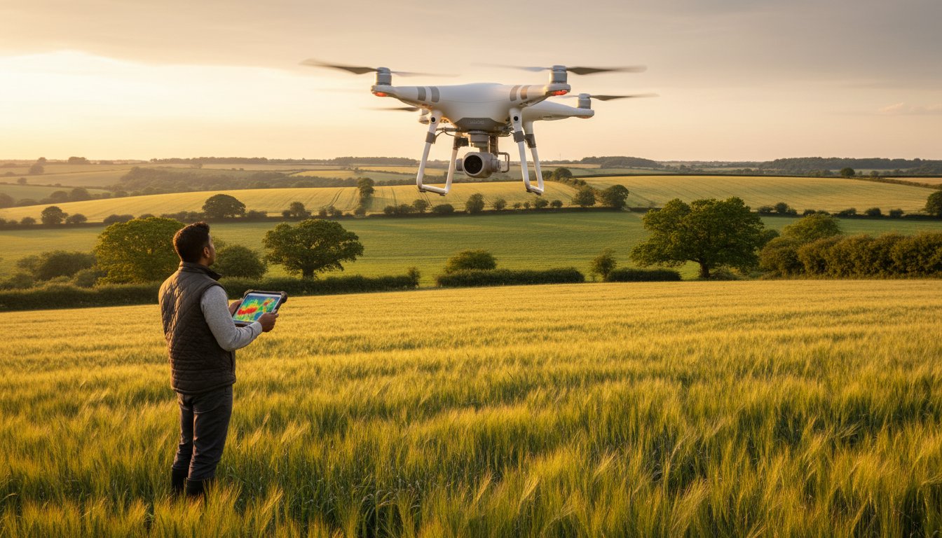
An agricultural drone survey is far more than just capturing aerial photographs of your land. It is a highly specialised data-gathering operation central to modern Precision agriculture. Instead of simple images, our CAA GVC Certified pilots use drones equipped with advanced sensors to collect vast amounts of specific, measurable data about your crops and soil. This professional service transforms raw information into a powerful tool for optimising farm management, increasing yields, and reducing operational costs.
To see this technology in action, the following video provides a clear example of a UK-based drone survey during a wheat harvest.
Traditionally, assessing crop health involved time-consuming field walking or relying on expensive, often low-resolution satellite imagery. An agricultural drone survey uk operators provide offers a superior alternative, delivering data with unparalleled speed, accuracy, and granularity. This allows for targeted interventions, saving resources and boosting yields by identifying issues before they become visible to the naked eye.
The Technology: Understanding Drone Sensors for Farming
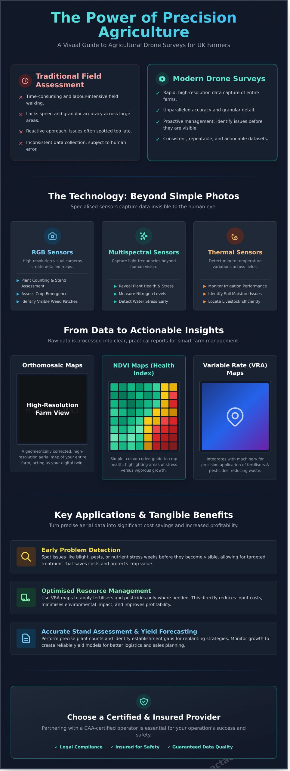
Our commercial drones are equipped with a range of sensors, each designed to capture different types of critical farm data:
- RGB Sensors: These high-resolution cameras produce detailed visual maps, ideal for plant counting, assessing crop emergence, and identifying visible damage or weed patches.
- Multispectral Sensors: By capturing light from frequencies beyond human vision, these sensors reveal crucial information about plant health, water stress, and nitrogen levels.
- Thermal Sensors: These detect temperature variations across your fields, helping to monitor irrigation system performance, identify soil moisture inconsistencies, and even locate livestock.
The Output: Translating Data into Actionable Insights
The raw data collected during a survey is processed into clear, practical reports that empower your farm management decisions:
- Orthomosaic Maps: A geometrically corrected, high-resolution aerial map of your entire farm, stitched together from hundreds or thousands of individual images.
- NDVI Maps: Normalised Difference Vegetation Index maps use multispectral data to create a simple, colour-coded guide to crop health, highlighting areas of vigorous growth versus those under stress.
- Variable Rate Application (VRA) Maps: These data-driven maps integrate directly with your farm machinery to enable precision application of fertilisers and pesticides exactly where needed, reducing waste and environmental impact.
Key Applications: How Drone Surveys Revolutionise UK Farming
Beyond a simple bird’s-eye view, professional drone surveys provide granular, actionable data that empowers UK farmers to make more informed, cost-effective decisions. By deploying specialised sensors, our CAA-certified operators can identify challenges and opportunities invisible to the naked eye, transforming farm management from reactive to proactive and unlocking significant operational efficiencies.
Crop Health and Yield Optimisation
Using advanced multispectral sensors, we generate detailed vegetation health maps (e.g., NDVI) to detect the early signs of crop stress. This allows for timely intervention against pests, diseases, and nutrient deficiencies weeks before they become visually apparent. This precise data-gathering is crucial for:
- Early Problem Detection: Spotting issues like potato blight or nutrient stress in wheat, allowing for targeted treatment that saves costs and protects crop value.
- Stand Assessment: Performing accurate plant counts and identifying gaps in establishment for crops like maize or sugar beet, providing clear data for replanting strategies.
- Yield Forecasting: Monitoring crop growth throughout the season to create reliable yield potential models, aiding in logistics and sales planning.
Resource Management and Cost Reduction
An effective agricultural drone survey uk is a powerful tool for optimising inputs and reducing waste. By mapping variability across your fields, you can move to a precision-based approach that saves money and minimises environmental impact. Key applications include:
- Precision Fertiliser Application: Creating variable-rate application (VRA) maps that direct spreaders to apply nutrients only where they are needed, potentially saving hundreds of pounds per field.
- Irrigation Efficiency: Utilising thermal cameras to quickly identify leaks, blockages, or uneven distribution in irrigation systems, conserving water and reducing energy costs.
- Targeted Weed Control: Identifying weed hotspots to enable precise spot-spraying, drastically reducing herbicide usage and cost compared to blanket applications.
Land and Infrastructure Management
Drones provide an unparalleled ability to map and monitor your entire holding quickly and safely. This high-resolution aerial data is invaluable for strategic planning, maintenance, and compliance.
- Boundary and Acreage Mapping: Using photogrammetry to create high-accuracy maps, verifying field boundaries and calculating precise acreage for planning or environmental stewardship scheme claims.
- Infrastructure Inspection: Safely monitoring the condition of drainage ditches, fences, tracks, and farm building roofs, allowing for proactive maintenance before minor issues become costly problems.
- Damage Assessment: Rapidly and safely surveying fields after a storm or flood to accurately assess the extent of damage for insurance claims and recovery planning.
The Survey Process: From Initial Consultation to Final Report
Embarking on your first agricultural drone survey is a structured, collaborative process designed to deliver actionable insights with maximum efficiency. We handle the technical complexities, allowing you to focus on your farm’s operational needs. For your peace of mind, every stage is conducted by CAA GVC certified professionals who prioritise safety and data accuracy above all else.
Step 1 & 2: Consultation and Flight Planning
The process begins with a detailed consultation to define your objectives. Are you looking to identify areas of water stress, monitor crop emergence, or assess pest damage? Understanding your goals allows us to plan the mission effectively. We then conduct thorough pre-flight checks, risk assessments, and ensure full compliance with Civil Aviation Authority (CAA) regulations. The flight is scheduled around key factors like weather conditions and the specific growth stage of your crops to ensure optimal data quality.
Step 3: On-Site Data Capture
On the day of the survey, our certified pilot will arrive on-site and establish a safe operational area. Using advanced multi-spectral sensors, the drone flies pre-programmed, automated flight paths over the designated fields. This ensures consistent, overlapping imagery essential for high-quality data. For tasks requiring centimetre-level precision, we establish Ground Control Points (GCPs), which act as fixed reference markers to guarantee the highest possible geographic accuracy for your maps.
Step 4: Data Processing and Analysis
Following the flight, the raw data is transferred to our powerful processing software. Thousands of individual images are meticulously stitched together using a technique called photogrammetry to create a single, high-resolution orthomosaic map of your field. From this, we generate critical analytical layers and health indices, such as:
- NDVI (Normalised Difference Vegetation Index): A colour-coded map highlighting variations in plant health and vigour.
- Digital Surface Models (DSMs): To analyse topography and water flow.
- Stand Counts: To assess crop emergence and population density.
The final deliverables for your agricultural drone survey uk are provided in a clear, usable format, typically including a comprehensive PDF report and data files like GeoTIFF, Shapefile, or KMZ for integration with your existing farm management software.
Calculating the ROI: Is a Drone Survey a Worthwhile Investment?
The primary consideration for any new farm technology is its return on investment. While there is an upfront cost to a professional drone survey, viewing it as an operational expense is a mistake. Instead, it should be seen as a strategic investment in precision agriculture-one that provides actionable data to significantly reduce input costs, mitigate risks, and increase overall profitability.
The value of an agricultural drone survey uk is not in the images themselves, but in the data-driven decisions they enable. By moving from estimation to evidence-based management, you can optimise resources and proactively address issues before they impact your bottom line.
Quantifying Cost Savings
Precise data-gathering directly translates into operational efficiency and reduced expenditure. Rather than treating an entire field uniformly, you can allocate resources exactly where they are needed. Tangible savings include:
- Reduced Input Costs: Using multispectral data to create variable rate application maps can reduce fertiliser and pesticide usage by 15-20%, saving thousands of pounds across a large acreage.
- Lower Labour Costs: Automated aerial scouting drastically reduces the man-hours required for manual crop walking, freeing up valuable time for other critical farm operations.
- Early Issue Detection: Identifying a single irrigation leak or drainage failure early can prevent costly water loss and localised crop damage, saving far more than the cost of the survey itself.
Quantifying Yield Increases
Beyond saving money, drone intelligence actively boosts your farm’s output. Early and accurate identification of crop stress allows for swift intervention, turning potential losses into gains. Key benefits include:
- Targeted Nutrient Application: NDVI maps clearly highlight areas of nutrient deficiency invisible to the naked eye. Addressing these specific zones ensures optimal plant health and can lead to significant yield improvements.
- Proactive Pest & Disease Management: Spotting the early signs of an infestation or disease outbreak allows for targeted treatment, preventing widespread crop failure and protecting your overall harvest.
- Long-Term Soil Health: Historical data from regular surveys helps build a comprehensive understanding of your land, enabling better long-term soil management strategies for sustained productivity.
When you compare the modest investment in a survey to the potential financial loss from a single undetected issue like blight or drainage failure, the ROI becomes clear. For professional analysis of your agricultural land, explore the data-gathering services offered by our CAA GVC Certified team.
Choosing a Provider in the UK: Why Certification and Experience Matter
When commissioning an agricultural drone survey in the UK, the provider you choose is as critical as the technology itself. The market includes both hobbyists and certified professionals, and the difference impacts not only the quality of your data but also your legal and financial liability. Hiring an unqualified or uninsured operator exposes your farm to significant risks, from inaccurate results to legal penalties in the event of an accident. Professionalism and compliance are the foundation of reliable, actionable data.
To ensure you receive top-quality service and legally compliant operations, it’s vital to vet any potential provider thoroughly. Use the following points as a checklist to make an informed decision.
Non-Negotiable Credentials
Any professional drone service you consider must hold these essential qualifications as a minimum standard. Never proceed without verifying them.
- CAA GVC Certification: The General Visual Line of Sight Certificate (GVC) is a legal requirement from the Civil Aviation Authority (CAA) for most commercial drone operations in the UK. This certification proves the operator has undergone rigorous training and assessment in flight safety, planning, and air law.
- Commercial Drone Insurance: A reputable provider will hold specialist commercial liability insurance, typically with a minimum cover of £5 million. For added peace of mind, this protects your property, livestock, and staff.
- A Detailed Agricultural Portfolio: Ask to see examples of previous farm surveys. A provider with a strong portfolio can demonstrate their experience in capturing and processing the specific types of data you need, from crop health assessments to elevation mapping.
Beyond the Basics: What Defines a True Expert
While certification and insurance are essential, a true specialist offers far more than just a license to fly. An expert partner understands the agricultural sector and how to turn aerial data into a tangible asset for your business.
- Expertise in Agricultural Data Analysis: The best providers are not just pilots; they are data specialists who understand how to interpret NDVI, VARI, and other vegetation indices to provide actionable insights for crop management.
- Commercial-Grade Equipment: An expert will use advanced commercial drones equipped with high-resolution multispectral and RGB sensors specifically designed for precision agriculture.
- Software and FMS Compatibility: A key question to ask is whether the provider can deliver survey outputs in formats (e.g., GeoTIFF, Shapefile) compatible with your existing Farm Management Software (FMS), allowing for seamless integration into your variable rate application plans.
Investing in a properly qualified and experienced operator ensures your agricultural drone survey uk delivers a genuine return on investment through accurate, reliable, and legally compliant data. Trust your survey to our certified and insured professionals.
Harnessing Data for a More Productive Harvest
As we’ve explored, the benefits of precision agriculture are no longer a distant future-they are an accessible reality for UK farms. From optimising irrigation and nutrient application to identifying crop stress before it impacts your yield, a professional agricultural drone survey uk provides the critical, data-driven insights needed to maximise efficiency and profitability. The key to unlocking this potential lies not just in the technology, but in the expertise of the operator.
Choosing a professional provider is paramount for safety, compliance, and data quality. At Impact Aerial, we deliver more than just images; we provide actionable intelligence. Our pilots are fully CAA GVC Certified experts in multispectral and thermal data analysis. For your complete peace of mind, all operations are backed by £5m in commercial liability insurance, ensuring a service that is both compliant and reliable.
Ready to transform your agricultural operations? Get a quote for a professional agricultural drone survey today and take the first step towards a more sustainable and profitable future for your farm.
Frequently Asked Questions
How much does an agricultural drone survey cost in the UK?
The cost of an agricultural drone survey in the UK is tailored to the specific requirements of your farm. Pricing depends on factors such as the total acreage (hectares) to be covered, the type of data required (e.g., multispectral NDVI vs. high-resolution RGB), and the complexity of the final report. As a guide, prices for a professional survey can start from approximately £350 for smaller holdings, with comprehensive projects for larger estates being quoted on an individual basis to ensure value and precision.
What is the difference between drone surveys and satellite imagery for farming?
The primary differences are data resolution and operational flexibility. Drones fly at lower altitudes, capturing ultra-high-resolution imagery that can identify issues at the individual plant level. Importantly, drone flights are not hindered by cloud cover and can be deployed on demand. Satellite imagery covers vast areas but offers much lower resolution and is dependent on fixed schedules and clear weather, which can delay the delivery of time-sensitive data for critical farm management decisions.
How quickly will I receive the data and reports after the drone flight?
Our professional data-gathering process is designed for efficiency. Following the completion of the on-site flight, you can typically expect to receive the initial raw imagery within 24 hours. The fully processed data, including detailed outputs like crop health maps, plant counts, and analytical reports, is generally delivered within 2 to 4 business days. This allows you to gain actionable insights quickly and make timely interventions to optimise your crop health and yield.
Can agricultural drones operate in bad weather like wind or rain?
As a safety-conscious, CAA GVC Certified operator, we adhere to strict operational limits. Our commercial drones can operate effectively in moderate winds, typically up to 22 mph. However, we do not fly in rain or high winds. This is to guarantee the safety of the operation and, crucially, to ensure the integrity of the sensor data, as moisture can affect readings. For added peace of mind, all flights are meticulously planned around suitable weather forecasts.
What time of year is best to conduct a drone survey for my crops?
The optimal timing for an agricultural drone survey UK depends entirely on your objective. Early-season flights are excellent for assessing crop establishment and generating accurate plant counts. Mid-season surveys are vital for identifying areas of stress, disease, or nutrient deficiency when corrective action is most effective. Later in the season, data can be used to inform yield predictions and plan for harvest logistics. We can advise on a schedule that aligns with your specific crop cycle.
Can drones be used for spraying pesticides or fertilisers in the UK?
While the technology exists, the use of drones for the aerial application of pesticides or fertilisers is highly restricted in the UK. It requires specific, complex permissions from the Civil Aviation Authority (CAA) and the Health and Safety Executive (HSE), which are not commonly granted for general agricultural use. Our professional services are focused on providing high-quality data-gathering and analysis to support precision agriculture, ensuring full compliance with current UK regulations.