Choosing the right surveying method for your UK project often comes down to one critical question: is the new technology a sound investment? When evaluating the drone survey vs traditional survey cost, the initial quotes can be deceptive. A lower price from a traditional team might seem like the obvious choice, but does it factor in the hidden costs of longer timelines, increased on-site risks, and potential data gaps? Conversely, the advanced capabilities of a drone survey can appear more expensive upfront, making it difficult to build a clear business case for your stakeholders.
This in-depth analysis is designed to provide clarity. We will move beyond surface-level figures to deliver a complete UK breakdown, comparing not just the price in pounds sterling but the true value delivered by each method. We’ll examine how factors like speed, safety, and data quality create a comprehensive picture of your return on investment. By the end of this guide, you will have the evidence-based understanding needed to confidently choose the most cost-effective solution for your project and justify your decision with professional, data-driven insights.
Key Takeaways
- Grasp the key components of traditional survey pricing, from labour-intensive fieldwork to equipment hire, to establish a clear cost baseline for your project.
- Analyse the complete drone survey vs traditional survey cost breakdown, with scenario-based examples to help you accurately forecast your project’s budget in the UK.
- Discover how the speed, enhanced safety, and superior data quality of drone surveys deliver a significant return on investment that extends far beyond the initial quote.
- Learn to identify a cost-effective and compliant provider by understanding the essential CAA certifications and insurance required for any professional UK drone operator.
Understanding the Cost Structure of Traditional Surveys
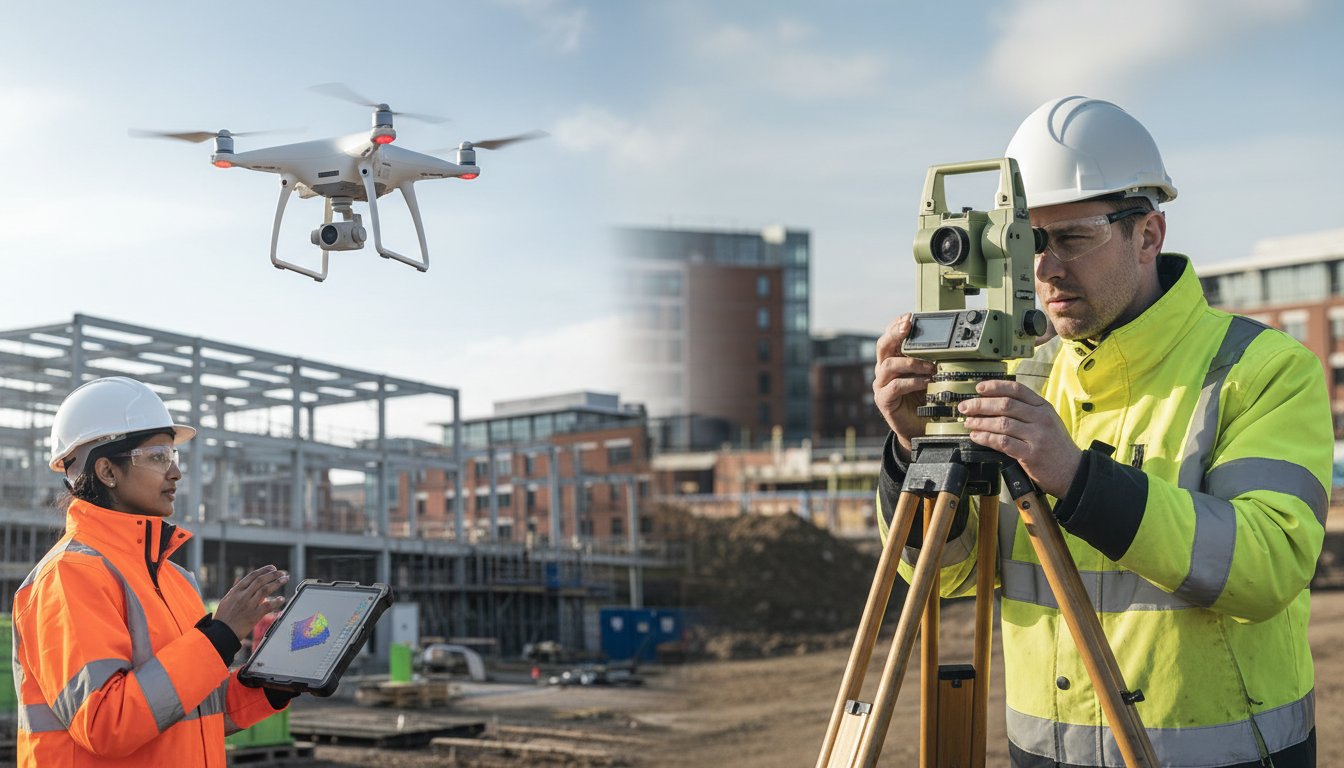
To accurately evaluate the drone survey vs traditional survey cost, it is essential to first establish a baseline by understanding the financial components of conventional land surveying. For decades, these methods have been the industry standard, relying on meticulous, ground-based measurements. However, this precision comes at a price, driven by factors that make it a labour-intensive and time-consuming process. Unlike modern aerial surveys that leverage advanced photogrammetry techniques to capture vast areas quickly, traditional approaches are inherently linear and ground-focused.
To see a direct comparison of the outputs from both methods, the following video provides a clear visual breakdown:
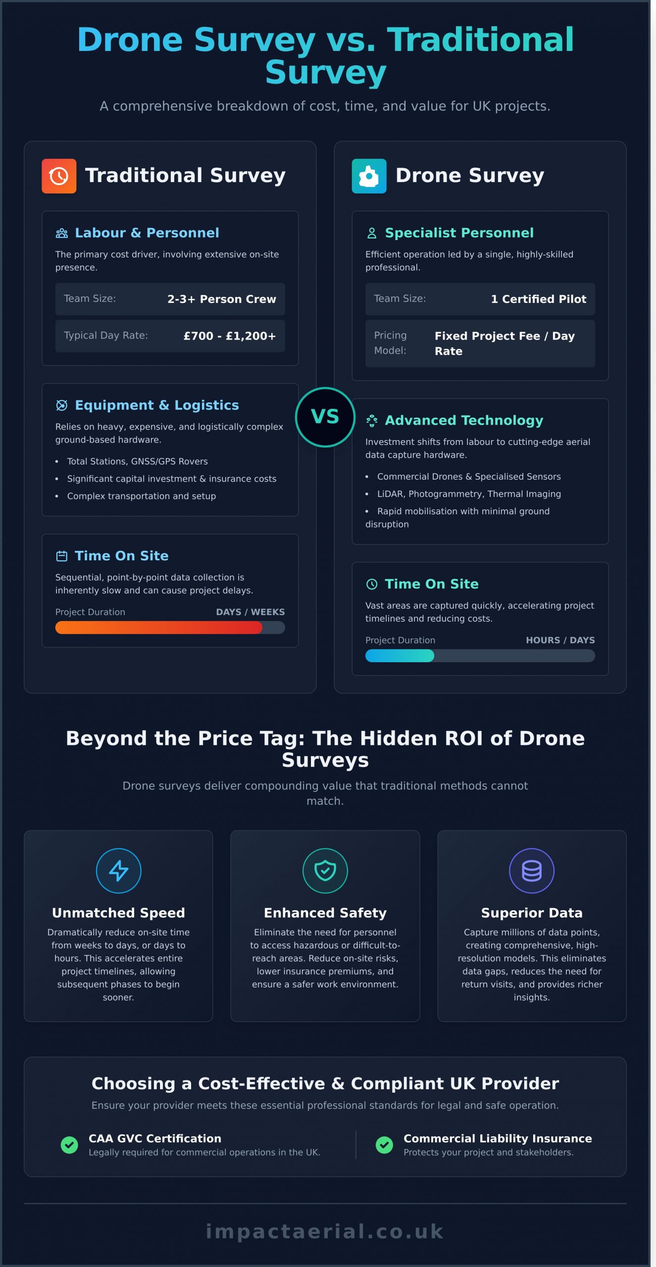
Labour and Personnel Costs
The primary driver of cost in a traditional survey is personnel. A typical project requires a qualified lead surveyor and at least one or two assistants on-site. Their billable hours encompass not just the data collection itself but also travel to and from the site, initial setup, and equipment tear-down. For projects located in remote areas or locations with difficult access, these labour costs can escalate significantly due to increased travel time and potential overnight expenses, with day rates for a survey team often starting from £700-£1,200 or more.
Equipment and Logistics
Conventional surveying relies on highly specialised and expensive equipment. Instruments such as total stations, GNSS/GPS rovers, and 3D laser scanners represent a significant capital investment, often costing tens of thousands of pounds. The maintenance, calibration, and insurance for this gear are factored into the overall project price. Furthermore, the logistics of securely transporting this sensitive equipment and the survey team to the site add another layer of complexity and cost, particularly for large-scale projects where physical obstructions can cause delays.
Time on Site
One of the most significant factors influencing the overall drone survey vs traditional survey cost is the time required on site. With traditional methods, data is collected point-by-point in a sequential process that can take multiple days or even weeks for extensive or complex terrains. Each additional day on site directly translates to higher costs for both labour and equipment hire. This slower pace not only inflates the survey budget but can also create bottlenecks, delaying subsequent phases of a construction or development project.
Analysing the Cost Components of a Professional Drone Survey
Understanding the final quote for a drone survey requires looking beyond simple flight time. Unlike traditional surveying, where costs are heavily weighted towards on-site labour hours and heavy equipment mobilisation, the drone survey model shifts the investment towards technology, specialist expertise, and sophisticated data processing. This fundamental difference is key to evaluating the drone survey vs traditional survey cost and appreciating the value delivered.
A professional quote is a comprehensive breakdown of the technology and skills required to capture precise, actionable data safely and legally. Below, we detail the core components that influence the final price.
Technology and Equipment
The initial investment in professional-grade equipment is substantial. We utilise leading commercial drones, engineered for reliability and data accuracy. The cost is further influenced by the payload; specialised sensors for tasks like LiDAR (Light Detection and Ranging), thermal imaging, or high-resolution photogrammetry represent a significant capital outlay. However, this technology allows for rapid mobilisation with minimal ground disruption, a stark contrast to the logistics of traditional survey teams.
Operational and Pilot Fees
Drone survey projects are typically priced on a fixed project fee or a day rate, which reflects the complexity and duration of the on-site data capture. This fee is not just for a pilot; it covers the services of a highly skilled, CAA GVC Certified operator responsible for meticulous mission planning, risk assessments, and safe flight execution. For your complete peace of mind, this cost component also includes comprehensive commercial liability insurance, often covering up to £5 million, a non-negotiable aspect of any professional operation.
Data Processing and Deliverables
The work is far from over when the drone lands. The raw data captured during the flight is then processed using powerful photogrammetry software to transform thousands of images into precise, measurable outputs. The complexity of these final deliverables is a primary factor in the overall drone survey vs traditional survey cost. The more intricate the data required, the more processing time is involved. Common deliverables include:
- Orthomosaics: High-resolution, geographically corrected aerial maps.
- 3D Point Clouds: Dense collections of data points to create detailed 3D representations of a site.
- Digital Surface Models (DSM) & Digital Terrain Models (DTM): Accurate models of a site’s surface and bare-earth elevation.
- Detailed Inspection Reports: Annotated imagery and analysis for infrastructure or building assessments.
Head-to-Head Cost Comparison: Scenario-Based Analysis
To move beyond general figures, a scenario-based analysis provides the clearest picture of the drone survey vs traditional survey cost. We will examine three common projects within the UK construction and property management sectors, highlighting the tangible savings in both project timelines and budget expenditure. The following table offers a high-level overview before we delve into specifics.
| Factor | Traditional Survey | Drone Survey |
|---|---|---|
| Time On-Site | Multiple days to weeks | Hours to 1-2 days |
| Personnel Required | Team of 2-3 surveyors | Single CAA GVC Certified pilot |
| Primary Costs | Labour, specialised ground equipment | Pilot time, data processing |
| Safety & Risk | Moderate to high (terrain, working at height) | Significantly lower, mitigates on-site risk |
| Data Deliverables | 2D plans, discrete data points | High-res orthomosaics, 3D models, point clouds |
Scenario 1: 10-Acre Construction Site Topographic Survey
A traditional ground team would typically require 2-3 days on-site, using total stations and GPS rovers. The labour-intensive nature of this work could result in a cost upwards of £2,500. Conversely, a single drone pilot can capture more comprehensive data for the same site in just a few hours. This rapid data-gathering, costing between £800 – £1,200, provides project managers with actionable topographic data by the next business day, accelerating critical planning decisions.
Scenario 2: Commercial Warehouse Roof Inspection
Traditionally, inspecting a large commercial roof necessitates costly access solutions like scaffolding or Mobile Elevating Work Platforms (MEWPs), which can cost thousands of pounds alone. Add the significant health and safety risks of working at height, increased insurance premiums, and a multi-day timeline. A drone survey eliminates these factors entirely. An inspection can be completed in a single day for a fraction of the cost (£600 – £1,000), with zero risk to personnel and minimal disruption to business operations.
Scenario 3: 50-Acre Land Survey for Development
For large-scale land development, the cost disparity becomes even more pronounced. A ground-based survey could take a team several weeks, leading to labour costs exceeding £10,000 and the potential for data gaps in inaccessible areas. A professional drone survey can cover the entire 50-acre site in 1-2 days of fieldwork. The result is a complete, high-resolution dataset that forms a valuable ‘digital twin’ of the property for a cost typically in the range of £2,500 – £4,500, representing a major saving in operational efficiency.
Beyond the Price Tag: The Hidden ROI of Drone Surveys
When evaluating the drone survey vs traditional survey cost, it’s a common mistake to focus solely on the initial invoice. A forward-thinking project manager understands that the true financial impact is measured in overall project efficiency, risk mitigation, and the quality of decision-making. Drone surveying is not just a line-item expense; it is a strategic investment that delivers a significant return on investment (ROI) through secondary benefits that traditional methods simply cannot match.
By shifting the perspective from a simple cost comparison to a value analysis, the advantages of modern aerial data-gathering become exceptionally clear.
Accelerated Project Timelines
Time is money in any construction, development, or land management project. Drones can survey vast or complex sites in a fraction of the time required for a ground crew, often reducing data collection from weeks to a single day. This rapid turnaround means that planning, design, and construction phases can commence far sooner, directly reducing labour costs, equipment hire, and site holding fees. Furthermore, regular progress monitoring with drones provides stakeholders with timely, verifiable updates, ensuring projects stay on track and on budget.
Drastically Improved Safety
The safety benefits of drone surveying translate directly into financial savings. By removing the need for personnel to work in hazardous environments, you fundamentally reduce project risk. This includes:
- Eliminating work at height on unstable roofs or structures.
- Avoiding access to dangerous terrain like steep embankments or quarries.
- Minimising time spent near live traffic or heavy machinery.
This proactive approach to safety not only protects your team but also reduces liability, mitigates the risk of costly project shutdowns due to accidents, and can contribute to lower insurance premiums for your project.
Richer Data for Better Decisions
While a traditional survey provides a series of precise points, a drone survey captures millions of data points using photogrammetry, creating a comprehensive and highly detailed digital twin of your site. This wealth of information significantly de-risks a project by reducing the chance of costly errors and rework. With high-resolution orthomosaic maps, 3D models, and accurate volumetric calculations at your fingertips, you can make more informed decisions on everything from earthworks and drainage planning to resource allocation and asset management.
Ultimately, the discussion of drone survey vs traditional survey cost is incomplete without factoring in these powerful ROI drivers. Investing in high-quality aerial data is an investment in a safer, faster, and more profitable project outcome. To see how our professional drone services can enhance your next project, contact Impact Aerial today.
How to Choose a Cost-Effective and Compliant Drone Survey Provider
When evaluating the drone survey vs traditional survey cost, it’s tempting to select the lowest quote. However, true value lies in securing accurate, reliable data while ensuring complete legal compliance and safety. A cheap service from an unqualified operator can introduce significant risks, delays, and liabilities to your project. Choosing a professional drone survey provider is not just a purchase; it’s an investment in quality and peace of mind.
To protect your project and ensure you receive high-quality results, use the following criteria to vet any potential provider. A reputable company will welcome these questions and provide clear, verifiable answers.
Verify CAA GVC Certification and Permissions
In the UK, commercial drone operations are regulated by the Civil Aviation Authority (CAA). Any professional pilot must hold a General Visual Line of Sight Certificate (GVC) and have valid Operational Authorisation from the CAA. This is a non-negotiable legal requirement. This certification proves the operator is trained, competent in flight planning, and adheres to strict safety protocols, protecting your site, your staff, and the public from the risks of unqualified pilots.
Confirm Adequate Commercial Liability Insurance
Professional drone operators must carry specialist commercial liability insurance. For added peace of mind, ask for a copy of their insurance certificate and ensure it provides adequate cover for your project, typically at least £5 million. This protects your assets and provides a crucial safety net in the unlikely event of an incident. At Impact Aerial, we provide our insurance documentation without hesitation, demonstrating our commitment to professional and responsible operations.
Assess Industry Experience and Equipment
A low price may reflect outdated equipment or a lack of specific expertise. Enquire about the drones and sensors they intend to use for your survey-are they fit for purpose? More importantly, ask for evidence of their experience in your sector. A provider with a strong portfolio of construction, property, or infrastructure projects will understand the specific data-gathering requirements and potential challenges. Their proven track record is a key indicator of the quality you can expect.
View our portfolio of professional survey projects.
The Final Verdict: Balancing Cost and Value in Modern Surveying
The debate over drone survey vs traditional survey cost reveals a clear evolution in the UK surveying industry. While traditional methods remain viable for certain tasks, drone technology consistently delivers a more efficient, safer, and often more affordable solution, particularly for large or complex sites. The true value, however, extends far beyond the initial quote; the high-resolution data, rapid turnaround times, and significant reduction in on-site risks provide a compelling return on investment that older methods struggle to match.
Choosing the right partner is paramount to realising these benefits. At Impact Aerial, we provide professional survey solutions meticulously tailored to the Construction, Property, and Building sectors. As a fully insured and CAA GVC Certified operator utilising commercial-grade DJI Enterprise drones, we deliver precise, compliant, and actionable data you can trust. For added peace of mind, our expertise ensures your project adheres to the highest standards of safety and quality.
Request a professional drone survey quote for your project today and discover how our advanced aerial data can enhance your project’s efficiency and profitability. Make the informed choice for a smarter, safer future.
Frequently Asked Questions
Is a drone survey always cheaper than a traditional survey?
While not always the case for very small, straightforward plots, a drone survey is typically more cost-effective for larger or complex sites. The primary savings come from reduced time on-site, smaller survey teams, and eliminating the need for expensive equipment like scaffolding. When evaluating the drone survey vs traditional survey cost, the rapid data acquisition and enhanced safety on difficult-to-access sites often deliver significant financial and operational advantages for most commercial projects.
How much does a typical drone roof survey cost in the UK?
In the UK, a drone roof survey for a standard residential property typically costs between £250 and £450. For larger, more complex commercial or industrial buildings, the price can range from £500 to over £1,500. The final cost is determined by the building’s size, the complexity of the roof structure, and the specific deliverables required, such as thermal imaging analysis or a detailed condition report. Always request a detailed quote for your specific project.
Are there any hidden costs I should be aware of with drone surveys?
A professional, CAA GVC Certified operator should provide an all-inclusive quote to ensure there are no surprises. Potential additional costs to clarify upfront can include advanced data processing for 3D models, significant travel to remote locations, or obtaining non-standard flight permissions in restricted airspace. For added peace of mind, ensure all deliverables and potential variables are clearly outlined in the initial proposal to avoid unexpected fees upon project completion.
How does the accuracy of a drone survey affect its overall value?
The accuracy of a drone survey is fundamental to its value. High-precision data, often achieving centimetre-level accuracy with RTK/PPK technology and Ground Control Points, ensures the outputs are reliable for critical applications like construction planning and design verification. A less accurate survey might be cheaper initially, but its data is unsuitable for professional decision-making, ultimately offering poor value and potentially leading to costly project errors. High-quality data-gathering is a direct investment in project certainty.
Can drone surveys be used for legally binding boundary surveys?
In the UK, while a drone produces exceptionally accurate topographical maps and visual evidence of boundaries, it is a data-gathering tool. For a boundary survey to be legally binding and registered with HM Land Registry, the final plans must be prepared and certified by a RICS Chartered Land Surveyor. Professional drone operators often work in conjunction with chartered surveyors, providing the high-quality aerial data that informs their expert legal determination and sign-off.
Does bad weather impact the cost of a drone survey?
Yes, adverse weather directly impacts drone operations and can affect scheduling and cost. For safety and data quality, drones cannot fly in high winds, heavy rain, or fog, which can lead to postponements. While a professional provider will have contingency plans, there could be standby fees if a team is already on-site and unable to work. It is crucial to discuss weather contingency policies with your operator before the project begins to avoid any unexpected charges.